Continued water supply problems throughout the Northeast and Eastern Wheatbelt have emphasized the need for development of an integrated approach to water supply both on and off the farm. The development project and the sustainability of wool production systems supported the integration of farm water planning in focus catchment planning and the development of agricultural water supply areas to form a regional farm water plan. Agricultural water supply areas were identified as part of the regional agricultural water plan developed for the project.
The description of the water supply areas for the Northeast and Eastern Wheat Belt will assist landholders in developing new supplies and guide maintenance strategies and improvement of existing water resources. Five agricultural water supply areas were identified using natural resource management units covering different types of water supply development potential. The basic data used to develop water supply areas included soil type, landscape units, geology, hydrogeology, native vegetation, and existing on-farm water resources.
Introduction
Historical development of farm water resources
The importance of a reliable agricultural water supply in the Eastern Wheat Belt was first realized in the 1830s when the land east of the Darling Range was surveyed for suitable agricultural land. With the introduction of corrugated iron in the 1880s, farms were improved and usable water collection was doubled for household supplies. At the turn of the 20th century, stocking rates on pastoral leases rose and further improvements were made in domestic life.
10/9/1913 resulted in the following reply from the Water Supply Engineer: “The Dandanning and Wattoning area was too far to be included, that it was only 'a proposal' at that stage and that the development of local supplies was more the good alternative” (Maddock 1987). Further expansion took place in the wheat belt (after World War I) with the Soldiers' Settlement Scheme in the 1920s. The extension of the comprehensive water scheme north from Kellerberrin and Doodlakine took place in 1958 and led to an increase in the carrying capacity of livestock in the Trayning area.
Water deficiency
North-eastern and Eastern Wheatbelt biophysical environment
- Climate
- Geology
- Hydrogeology
- Land systems
- Vegetation
- Agricultural systems and water demand
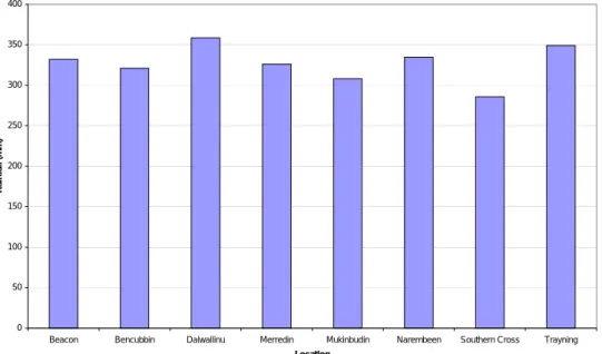
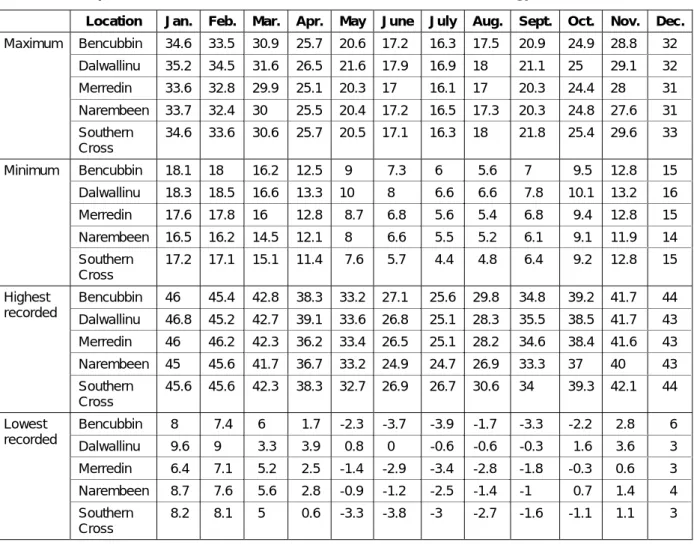
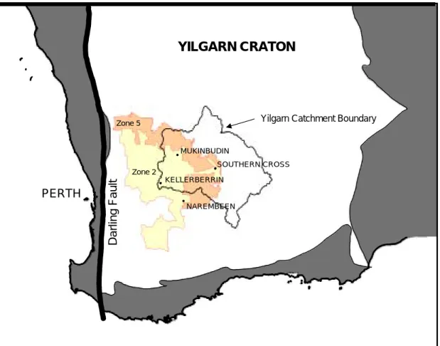
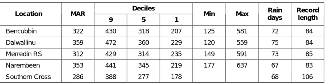
Precipitation variations for selected areas of the northeastern and eastern wheat belt (Source: Bureau of Meteorology 1998). Tertiary and Quaternary sediments of the Cenozoic era 60 million years ago dominate granite and gneiss rock (basement geology). These lake systems include Lakes Seabrook and Deborah which drain west into Lakes Brown and Wallambin of the Yilgarn watershed.
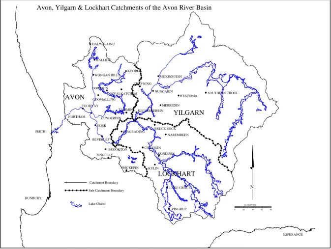
The Avon River basin consists of four main flow systems: the salt lakes of the eastern Yilgarn and Lockhart catchments; Salt River System in the central region of the Avon catchment; the rejuvenated Avon River Avon catchment; and the Swan River on the western part of the Darling Scarp (Figure 5). The salt river system and salt lakes are dominated by a linear chain of salt lakes which generally follow the paths of the older palaeodrainage system. Because of the high cost of drilling and the high salinity of most groundwater, few holes have been drilled to determine the hydraulic properties of the fractured basement aquifer system.
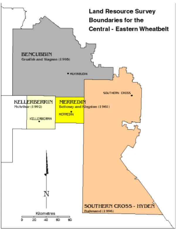
The transition zone between the unaltered rocks and the overlying saprolite is often more permeable than the bulk of the saprolite. More recent alluvium occurs in the upper part of the drainage system in narrow streams and channels of moderate gradient. The land resources of the Kellerberrin region (McArthur 1992) include eight land masses with similar landforms, soils and vegetation.
The Mt Caroline Vegetation System covers all of the Kellerberrin LGA and parts of Bruce Rock, Merredin and Trayning. Clay dam sites can be found near the edge of the granite outcrops and are indicated by larger shrubs and mallee. The understory consists of scattered shrubs of the kwongan plant community where the soil is sandy, and woodland species where the soil is clayey.
The valley floor of the Moorine Rock Vegetation System contains pure woodland with a mixture of salmon gum, gimlet and morel depending on the soil type. The woodland plant community of the Jibbering Vegetation System includes York gum which decreases towards the east, yorrel (E. yilgarnensis) only on saline land and may be associated with salmon gum or gimlet on the heavier soils. Dominant species of each plant community of each of the vegetation systems of the north-eastern wheat belt (after Beard 1979) Plant community.
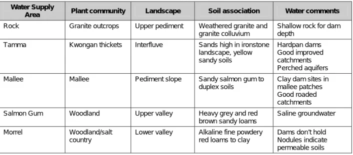
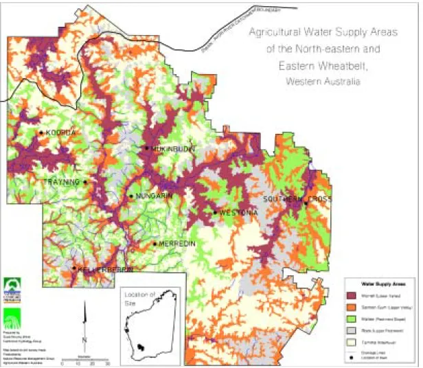
Agricultural water supply areas
- Tamma: Area 1
- Rock: Area 2
- Mallee: Area 3
- Salmon Gum: Area 4
- Morrel: Area 5
The success rate of developing groundwater, dams and watersheds was interpreted after reviewing 217 Farm Water Supply reports and local knowledge. The Tamma Water Supply Area occurs on gently undulating plains and rises in the highlands of watersheds. Farmland watersheds in the Tamma Water Supply Area generate insufficient runoff for a reliable water supply.
Areas of rock water supply include outcrops of granitic rock and soil formed from weathered granite or granitic colluvium. Areas of rock water supply generate large amounts of runoff that can cause erosion and gully formation down the slope. This water supply area is a good source of natural and enhanced catchment for collecting rainfall in dams to promote a reliable surface water supply.
Some of the best groundwater supplies occur in the Rock Water Supply Area, especially around granite outcrops. The Mallee Water Supply Area is linked to the pediment slope, which is situated between the valley and the catchment and occurs on undulating slopes to low hills. The best supplies tend to be found where Rock or Tamma water supply areas adjoin Mallee areas, or where drainage lines descend from these areas.
Natural farmland catchments in the Mallee Water Supply Area can provide good drainage, but a move to minimal tillage, stubble retention and high water use systems reduce runoff from farmland and often necessitate improved watersheds. Improved watersheds work well in the Mallee water supply area, but erosion will occur where slopes are too steep. Salmon gum water supply areas are located in upper valleys where the landscape consists of undulating plains forming broad valley floors with extremely low relief and very gently sloping slopes (Grealish and Wagnon 1995).
Salmon gum water supply areas are not considered high supply areas, although moderate supply may occur. As with the Mallee Water Supply Area, clay dams can be found in the Salmon Gum Water Supply Area. The Morrel water supply area is located on the lower slopes of the valleys and has little relief with almost flat slopes that often run along the drainage systems of salt lakes.
Farm water resources development
On-farm water supply planning
Farm water supplies for large enterprises are designed with a nominal reliability rating of at least 90%. However, many farm water supplies are rated as only 50 to 70% reliable, resulting in a large draw on the public scheme during years of relatively low rainfall. A 20% improvement in the reliability of on-farm water supplies will generate a net gain for the public and the agricultural community, freeing up public funds to establish and maintain community and off-farm water supplies.
The Department of Agriculture and Food can provide information on the design, construction and maintenance of water supplies through Farmnotes, bulletins and 'freeware' software to help farmers assess the reliability of their water supplies. The Farm Water Grant Scheme (FWGS) is available for commercial broad acreage farming businesses to plan and invest in improvements to farm water supplies in zones. Farmers can claim 70% of expenditure on approved water supply improvement works up to the maximum grant approved.
Applicants have 18 months from the date of approval to complete the waterworks indicated in the application. The effectiveness of the FWGS is measured by the extent to which eligible farmers with serious water shortages use the scheme to improve their on-farm water supply. The objective is to identify communities most in need of improved water supplies and to encourage local government to submit water supply development proposals that result in rural communities being better prepared for years of low rainfall. .
Supplying Strategic Farming Areas: The Farm Water Plan identifies a strategic water source as an essential part of the emergency network available to provide emergency water supplies for livestock in times of declared water shortage. Renovation of water supplies in agricultural areas: Many of the existing strategic water supplies in agricultural areas are in a poor state of repair, and local governments wishing to renovate such supplies may be eligible. Construction of community water supplies: Local sites with good water supply potential, either on-farm or off-farm, may be suitable for development as a community water supply.
Extension of Water Corporation piped water supplies: Funding may be available for the construction of piped extensions to towns, strategic community water points and farms from Water Corporation supply schemes.
Water resources research: Needs and opportunities
- Community issues and attitudes
- Low adoption survey
- Focus catchment surveys
- Community water day
The focus catchments surveyed in 1997 were Yarragin TangPlang (Trayning LGA), Yeelanna (Trayning) and Wallatin Creek (Kellerberrin) in Zone 2 and all were linked to the comprehensive scheme. The Bodallin catchment has 53% of landowners in Zone 2 (linked to the comprehensive scheme) and 47% of landowners in Zone 5. The number of groundwater supplies developed in each catchment was Wallatin Creek (16), Yarragin TangPlang (6 ), Yeelanna (3) and Bodallin (8).
Dam sizes for all catchments show wide variation, with the average size for the Wallatin Creek, Yarragin TangPlang and Bodallin catchments between 1000 and 2499 cubic metres. Wallatin Creek had 13% of ewes and lambs with too high salinity, while Yarraga's TangPlang had 5% and Yeelanna 2%. A Community Water Day was held in Bencubbin in February 1998 as a forum to exchange information and identify issues and needs relating to water supply and agricultural water management.
Conclusion