Te Ao Māori values (Placeholder Page)
Tasman District Council Expectations
Regulatory Context
Introduction
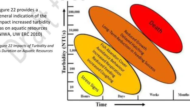
The effects of erosion and sedimentation have been studied in many countries over many decades, and such effects have been extensively studied in New Zealand. In addition to economic impacts, there are environmental impacts related to reduction in light penetration due to increased turbidity and suffocation of benthic aquatic organisms by sediment deposition.
Erosion Processes
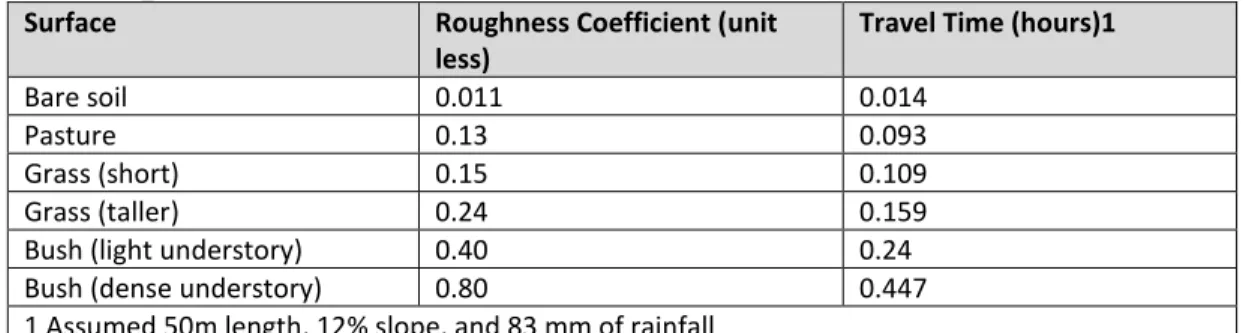
Rather than providing an accurate estimate of actual total sediment yield, the most useful use of the USLE is to help identify variations in potential sediment yields at a given site. The energy and erosion potential of flowing water increases with the square of the velocity.
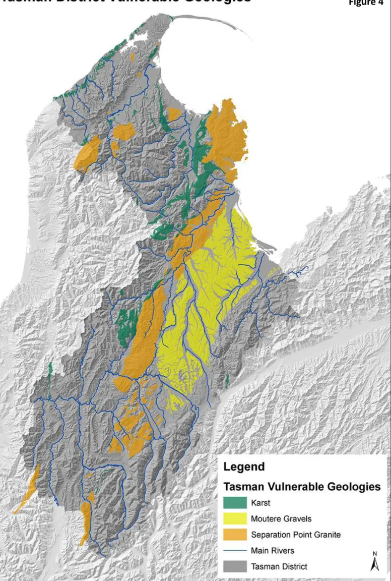
Vulnerable Geology and Soils in Tasman District
Karst landscapes are a result of the presence of soluble rock with soil fraying (collapse into underground crevices and caves), mainly influenced by surface water intrusion. More information about karst landscapes and managing the effects of land disturbance on them is available in section 3.3.
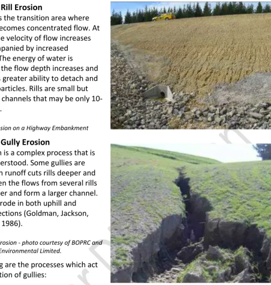
Types of Erosion
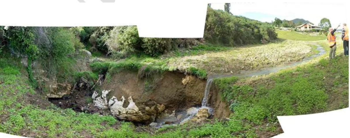
Gully erosion is a natural occurrence, but accelerated gully erosion is caused by a change in land use that increases the volume and rate of stormwater runoff. Wind erosion effects can occur during horticultural planting time and at earthwork sites when areas have been cleared of vegetation and a lack of soil moisture allows transport.
Non-sediment contaminants
Nutrient emissions are closely related to sediment runoff levels as water runoff from construction sites carries both soil and nutrients that occur naturally in the soil. Polycyclic Aromatic Hydrocarbons (PAHs) are found in the asphalt and tar used in road construction and repair and as byproducts of fuel combustion.
Sediment Transport Pathways
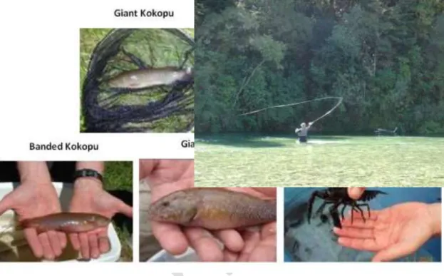
One aspect that is common to all host environments is the potential for human interaction, be it for recreational purposes, water use or food gathering. Understanding the potential users of receiving environments is an important aspect to include when considering the potential for receiving environmental impacts.
Adjacent properties
Having an awareness of where the water goes and the sensitivity of receiving environments will help determine erosion and sediment control requirements for land-disturbing activities. It is important to recognize that receiving environments have value, are vulnerable and require a higher level of protection than has previously been provided.
Infrastructure
Karst landscapes and cave systems
Accelerated erosion and changes in water flow paths can result in flooding, landslides or surface landslides (Richards 2003). Karst landscapes often include areas of particular cultural and spiritual significance as well as recreational importance, e.g. Harwood's Hole on Takaka Hill.
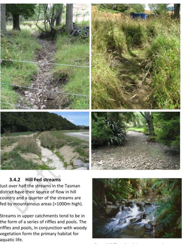
Streams and Rivers
Just over half of the streams in the Tasman district have their source in the hills, and a quarter of the streams are fed in the mountainous areas (> 1000 m high). Streams in the upper basins are usually in the form of a series of gullies and pools.
Wetlands
Understand where the wetlands are located on your property, and also downstream of your property, some wetlands may not be immediately apparent due to degradation from grazing and removal of vegetation, but if given a chance, these areas can regenerate or be restored. Wetlands often flow to other areas, treating all wetlands - even modified ones - as both receiving environments and potential sediment transport routes to others.
Lakes, farm ponds and dams
Ensure stockpiling does not occur within wetland boundaries or where sediment may enter wetlands. Ensure that stocking does not occur within or near the edges of the lake or where sediment may enter waterways that flow into the lakes.
Estuaries
In terms of sedimentation, the area of soft mud in some estuaries, particularly the Waimea and Motupipi, was very elevated (a "poor" rating) and growing in area in the Waimea estuary, having increased by 26% since 2001. Recent studies of the Moutere- the estuary has shown over a 170% increase in the area of soft mud substrates between 2006 and 2013 (from 14 to 38.1% of total substrates) and a "poor" rating.

Open coasts
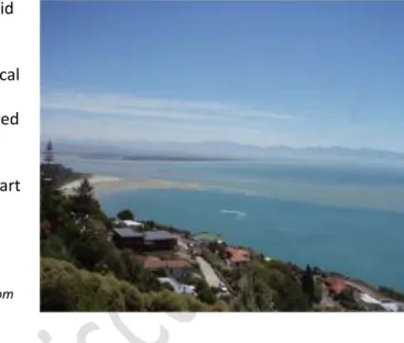
Clean water is something that people value as part of New Zealand's "Clean & Green" image, especially at the "gateway" of Abel Tasman National Park. Monitoring of the Motueka River plume as part of the Motueka Integrated Watershed Management project showed that the impact of the river plume extended about 7 km offshore from the mouth of the river and detectable sedimentation covered an area of about 180 km2, including areas of significant existing and potential fisheries value.
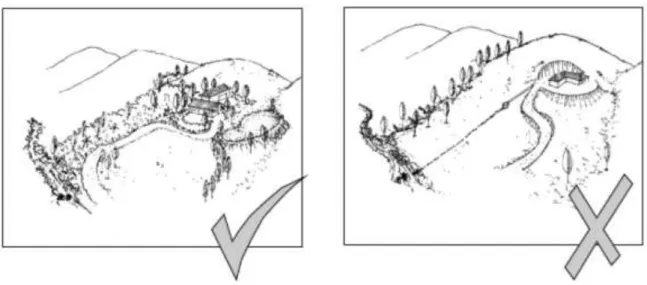
Visual Landscapes
The project manager has direct control over the first four points, and can use good site practice (refer Sections 5 and 6) and a risk-based approach to the design of erosion and sediment control measures to reduce the influence of the slope, geology and the appearance to minimize storm events. The scale of your Erosion and Sediment Control Plan (Section 6) should reflect the sensitivity of the receiving environments, the potential for sediment generation on your site and the pathways for sediment transport from your site, as a measure of your site's risk to sedimentation cause .
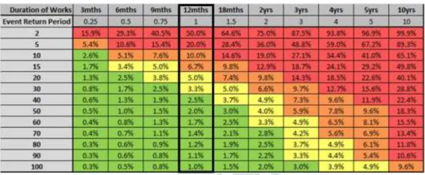
Levels of Risk included in Erosion and Sediment Control Design
These storm magnitudes represent the design storms required to achieve the desired level of protection for the various receiving environments. This table and risk approach is used in the erosion and sediment control design methodology that requires a specific design outlined in Appendix 12.5.
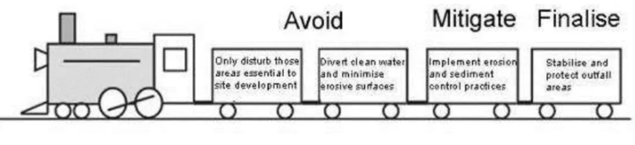
Key principles of erosion and sediment control
Key Management Concepts of Erosion and Sediment Control
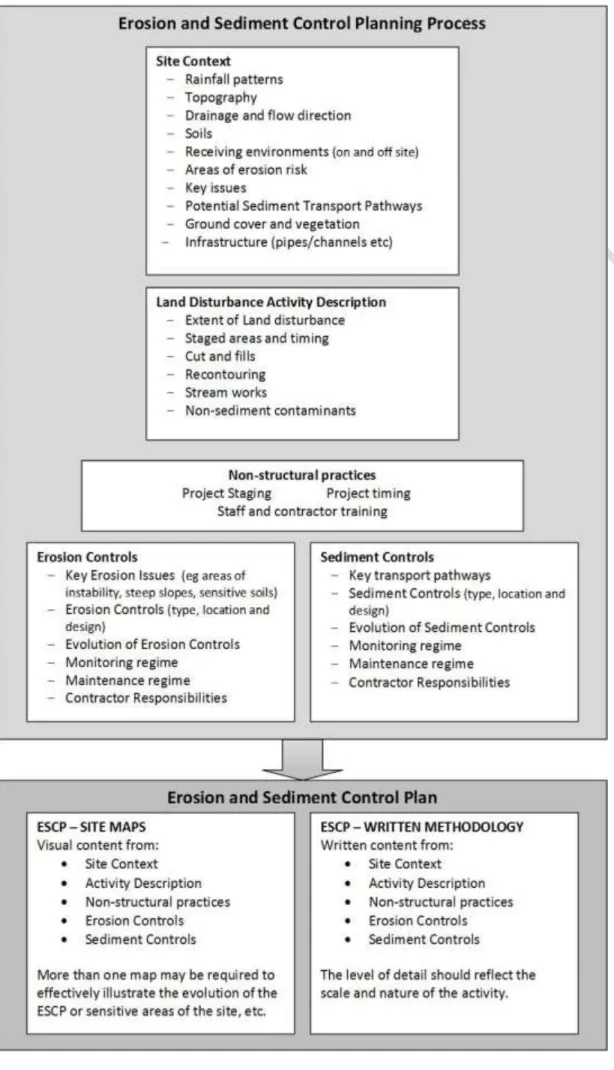
Erosion and sediment control planning is more than just creating a site control map, it is a process. The written methodology contains information on various aspects of the project and the proposed erosion and sediment controls.
When is an Erosion and Sediment Control Plan required?
The site plan provides a visual representation of what the site looks like and includes details such as the location of control equipment and other relevant features.
Site Plan Contents
Identification of no-go or buffer areas to be maintained on site Location and extent of topsoil and material stocks. Unique identifiers for each erosion and sediment control structure Size and area (in m2 or ha) of contributing watersheds for each E&SC device.
Methodology Contents
Site remedial works and trigger levels for sediment removal from E&SC should be provided. Contingency measures should be established in case of failure of any E&SC device.
Implementation of the ESCP
Any additional management measures proposed in case of heavy rain warnings should be listed here. This section should include the sequence and timing for construction of the E&SC and bulk earthworks.
Introduction
Water management controls
To be effective, place check dams so that the toe of the upstream dam is at the same height as the crest of the downstream dam. Check for scour at the base of the pipe fall structure or chute or in the receiving downstream area.
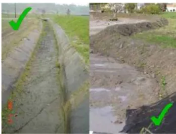
Soil Stabilisation Practices
The goal of the practice is to provide rapid stabilization by placing vegetative cover to stabilize exposed areas. A dust management plan can be included as part of the site erosion and sediment control plan.

Sediment Retention Pond
The length of the sediment retention basin is measured as the distance between the inlet and the outlet (ie the settling system). Ensure that all bare areas associated with the sediment retention basin (including internal blocks) are stabilized.

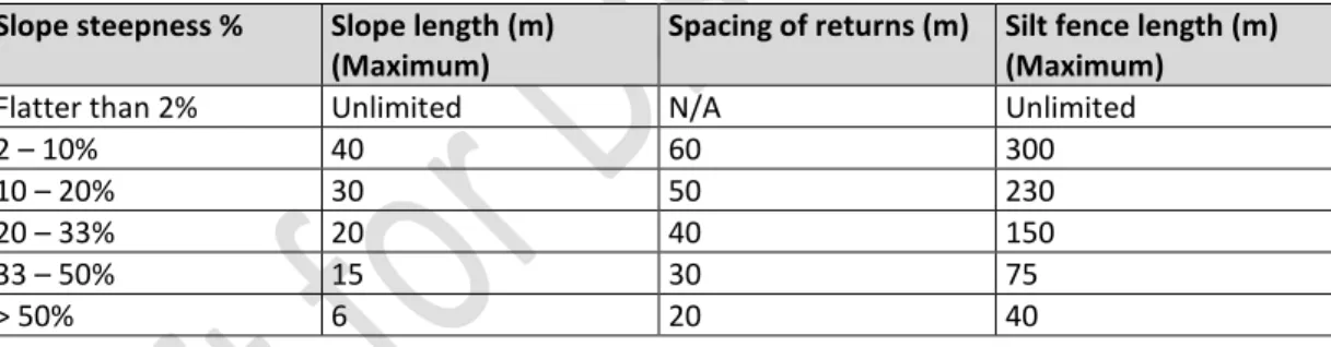
Silt fences
Dig a trench at least 100mm wide and 200mm deep along the proposed silt fence line. Tension the wire with permanent wire strainers attached to slanted frames at the end of the silt fence.
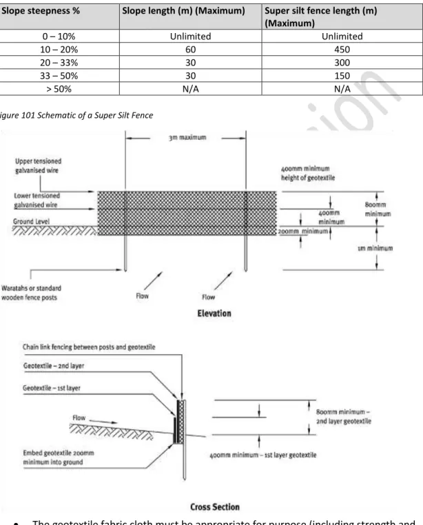
Super silt fence
Excavate a trench minimum 100mm wide and 200mm deep along the proposed line of the super mud fence. Do not remove the super mud fence until the catchment has been adequately stabilized.
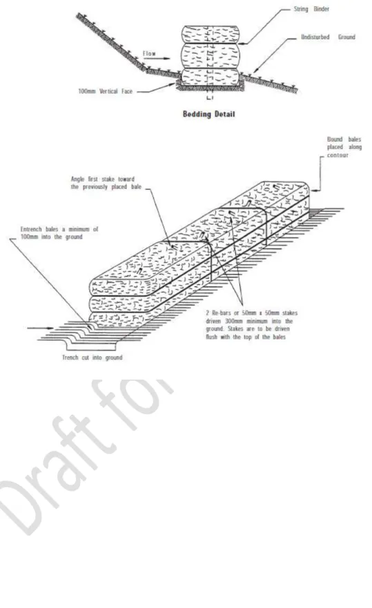
Straw Bale Barrier
Undercutting caused by water flowing under the structure or leaking between bales or abrasion caused by overhanging or exterior. If sediment settles behind the straw bale barrier, remove deposited sediment when the depth exceeds 30 percent of the height and dispose of removed sediment to an area where it cannot be washed into or onto receiving environments.
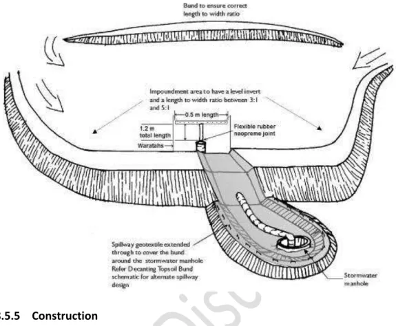
Decanting earth bund
The decanting soil base must be fixed in the existing soil to a minimum depth of 0.3 metres. The decanting soil bundle must be made with a clay-silt mixture of suitable moisture content to achieve a reasonable compaction standard (90%).
Flocculation
If a flocculant spills into pond water, it must be prevented from being discharged from the pond into natural water (streams, rivers, lakes, wetlands, etc.). Any further release of flocculant into the water should be prevented - The amount of spillage should be recorded.
Dewatering
Residual sediment-laden water can be pumped into a tank or truck and used as a dust suppressant. Smaller volumes of sediment-laden water can be pumped into specially designed storage tanks (eg modified tanks) or dewatering bags/socks.
Sediment Sump
If the water is to be pumped directly to a receiving environment, wrap geotextile fabric around the standpipe to help achieve a clean water discharge. Position the standpipe so that it extends 300mm above the outer edge of the sediment sump.
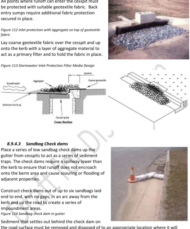
Stormwater inlet protection
Inlet protection shall not divert water over cuts or fills, down slopes, or away from storm water inlets. Stormwater ingress protection around inlets at low points should be set back to allow drainage to function normally during periods of heavy rain.
Non-Sediment Contaminant Effects
Non-sediment contaminants consist of chemicals and materials used on the site that flow directly or indirectly into receiving environments (including adjacent soils) from site activities. Some soil-disturbing activities, such as construction activities, can generate a variety of non-sediment contaminants, many of which are listed in Table 22.
Materials storage
Materials Use and Onsite Activities
Disposal
Contingency Planning
Store material in a location that is not subject to contact with rainfall. Use adhesives carefully and clean up any spilled material. Dispose of containers properly once empty Only clean brushes/applicators in areas that drain to sewers. Properly dispose of containers once empty Clean brushes/applicators only in areas that drain to sewers Concrete Cement Discoloration Alkalinity (high pH) Concrete truck chutes, pumps and insides must be washed out.
Introduction
There is also a general requirement that all sites comply with Part 6 of the TRMP regarding releases to land, air and water. All activities in the watercourse, including the placement of structures and diversion of water, will need to comply with Parts 4, 5 and 6 of the TRMP and may require resource consent.
What constitutes a watercourse?
If you are not sure about one. water flow or identifying where the river bed is for approval purposes, seek advice from the Council. Artificial watercourses still contain water and are subject to the rules in Parts 5 and 6 of the TRMP regarding water intakes, diversions and discharges.
Where is the bed of a river?
In all other cases, the land area covering the upper level lake waters without exceeding the rim; And. in respect of any lake controlled by artificial means, the land space covering the waters of the lake at the maximum allowable operating level; and (d).
Types of Activities and Methods of Protection
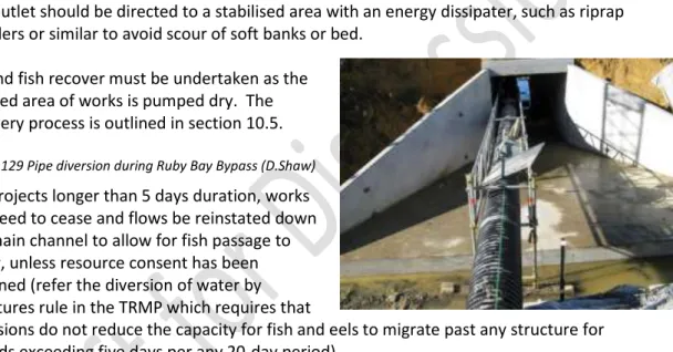
For the purposes of esplanade reserves, esplanade strips and subdivision, the land space covering the waters of the lake at the annual highest level without exceeding the rim:. ii). For example, recovery of fish and eel may be necessary for many stream and river works.
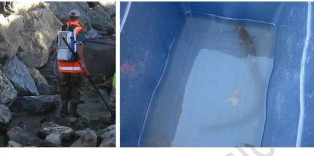
Eel and fish recovery
Ecological sampling should be undertaken to determine the type and abundance of fish populations in the work area to help identify appropriate mitigation methods. If dredged bed sediments are disposed away from the channel (i.e. to a designated disposal site) - carefully distribute the dredged bank and bed materials at the disposal site to allow eel and fish foraging and recovery and transfer back to the stream of water to be released.
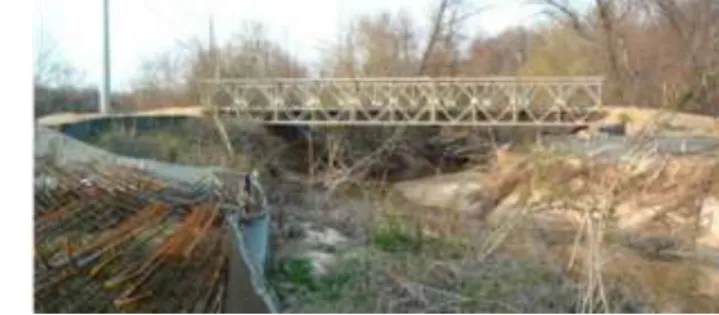
Temporary watercourse crossings
Where possible, culvert removal and channel bed stabilization to restore full channel flows prior to storm events. Ensure that all loose construction materials and machinery are out of the channel and possible floodways before storm events occur.
Diversion by coffer dam
Dam removal where feasible to restore full channel flows ahead of storm events. Provision for temporary stabilization of the work area prior to eventual flooding based on predicted warnings.
Diversion by damming and piping
Where feasible, removal of the dams and pumps to restore channel flows ahead of storm events. Regular inspection and maintenance of the pump to ensure that the pump continues to operate at the required capacity.
Diversion by temporary channel
If there are fish trapped in the initial water flow as a result of the diversion, those fish should be captured and moved to the live section of the water flow (refer to Section 10.5). Where possible remove dams and restore flows to the original channel prior to storm events.
Planning and design requirements
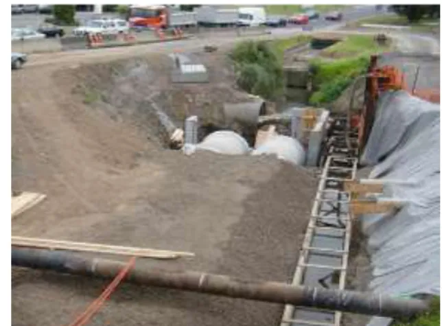
The installation of these utilities and services in a block of flats usually takes place towards the end of the extensive earthworks phase. The pumping of groundwater and rainwater from ditches creates sediment-laden water that is difficult to clean, especially on the roadway where these works are usually carried out.
Construction requirements
Bibliography
Muddy Waters: An Assessment of the National Economic Cost of Soil Erosion and Sedimentation in New Zealand. NZTA 2010 New Zealand Transport Agency, August 2010, Draft Erosion and Sediment Control Standard for National Highway Infrastructure.
Glossary
Hydrology The science of the behavior of water in the atmosphere, on the Earth's surface and underground. Soil The unconsolidated mineral and organic matter on the Earth's surface that serves as a natural medium for the growth of land plants.
Erosion and Sediment Control Plan - Symbols
Symbols for objects not listed in the following table can be used on ESCPs if they are clearly indicated in the map legend. Ideally, all slopes shown on the maps should be specified in percentage, ratio and degrees as indicated in the conversion table below.

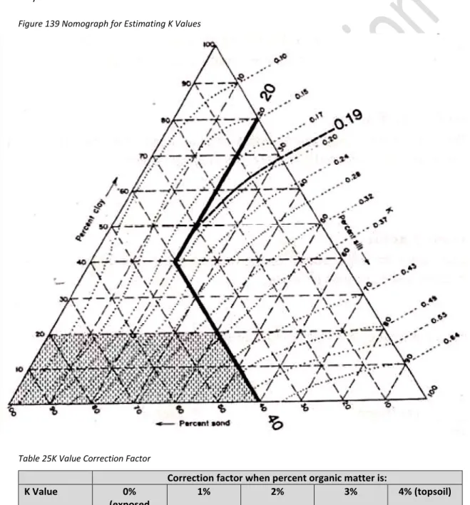
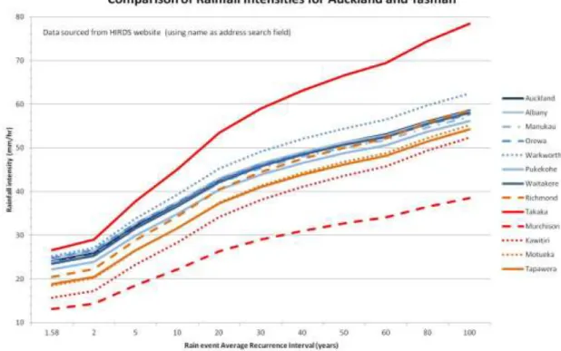
Universal Soil Loss Equation Information
To determine the LS factor, the slope length and slope gradient for the area of the site being evaluated must be known. Determining the appropriate runoff coefficient depends on the slope, soil type and ground cover.