Contents
RESIDENTIAL DIRECTION
Contents ... 2
Executive Summary ... 3
Introduction ... 4
Challenges ... 5
Aims and Objectives ... 6
Context ... 7
Methodology ... 13
Structure Plan ... 15
Findings ... 18
Key Directions ... 36
R1 Accommodate Population Growth ... 36
R2 Respond to Changing Housing Needs ... 43
R3 Provide a Sustainable Living Environment ... 47
R4 Facilitate Quality Housing Outcomes ... 53
Work to be Done ... 56
Monitoring & Review ... 57
References ... 58
Glossary ... 60
The Residential Direction was adopted by Council on 10 June 2008 Minute No. 414.
This document represents the collaboration of information from a number of sources, including Government Plans and Policies, and plans and policies of Baulkham Hills Shire Council.
ACKNOWLEDGEMENT
A priority of the NSW Government is to deliver a more effective planning system, making it more strategic, efficient and transparent while enhancing community involvement. Planning Reform Funds provided by the Department of Planning have assisted Council to complete this key strategic planning project.
COPYRIGHT NOTICE
This document may be reproduced for personal, in-house or non-commercial use.
Reproduction of this document for any other purpose shall only be permitted with the written permission of Baulkham Hills Shire Council.
DISCLAIMER
Every reasonable effort has been made to ensure that this document is correct at the time of printing. Baulkham Hills Shire Council disclaims all liability in respect of the consequences of anything done or omitted to be done in reliance upon any part of this document. The maps provided in this document are general in nature and should not be relied upon. This document is subject to change without notice.
Hunterford Estate, Oatlands
Executive Summary
RESIDENTIAL DIRECTION
The Residential Direction provides a statement of direction for the Shire. It reflects Council’s desired approach to guide the planning, protection and management of the Shire’s residential development.
The Direction has identified opportunities and mechanisms (both regulatory and non- regulatory) to improve the means by which residential development is planned and managed. It contains four Key Directions, supported by objectives, strategies and actions. It also identifies responsibility for each action identified.
KEY DIRECTIONS AND OBJECTIVES
R1 Accommodate population growth o Ensure that planning controls effectively
provide for balanced growth in the Shire’s population.
o Provide for well located housing close to services supported by appropriate infrastructure.
o Facilitate the timely delivery of planned residential development.
R2 Respond to changing housing needs o Provide for a diversity of housing choice
that is appropriate to residents needs.
o Promote a range of housing that is affordable to households of varying financial capacity.
R3 Provide a sustainable living environment
o Contribute to the development of communities that offer a sense of place and community connection.
o Improve the environmental sustainability of residential development.
o Manage potential conflicts between more intense land uses and residential amenity.
o Ensure the protection of the Shire’s cultural heritage as residential growth happens.
R4 Facilitate quality housing outcomes o Protect and enhance residential character
and streetscape in lower density residential development.
o Monitor and improve the design quality of higher density residential development.
Medium density housing
Introduction
RESIDENTIAL DIRECTION
This Residential Direction aims to give Council, the community and developers a clear strategy for the future planning and management of residential development and growth to 2031.
The Hills 2026 Community Strategic Direction looks towards a future of resilient local leadership, vibrant communities, balanced urban growth, a protected natural environment and a modern local economy. The Residential Direction will be one of a number of Council strategies to assist with achieving this vision.
The existing Residential Development Strategy, completed in 1997, identified several areas as suitable for medium and high density development. This strategy has been implemented over the past 10 years and, together with the development of the Rouse Hill Release Area, has provided for significant residential growth.
This Direction reviews progress in achieving additional dwellings and demonstrates the capacity to accommodate State Government dwelling targets into the future. It also addresses key housing issues such as special needs housing, affordability, sustainability, design quality and impacts on heritage, streetscape and residential character.
High density housing
Challenges
RESIDENTIAL DIRECTION
The characteristics of the Shire and housing market conditions present many challenges for the planning and management of residential development.
KEY CHALLENGES
• Encouraging timely delivery of residential development when faced with factors such as:
o
Perceived or real lack of viability for some forms of development.o
Fragmented ownership in release areas.o
Competing priorities for commercial or retail development close to centres.• Accommodating an ageing population in well located areas, supported by services and facilities when existing legislation allows such development on the urban fringe.
• Ensuring the garden image of the Shire is maintained whilst addressing housing mix and affordability objectives.
• Fostering and maintaining a sense of safety, community and streetscape character as the population grows.
• Balancing urban development pressures with ecological and environmental objectives.
Challenges are also created by external factors which can affect Council’s ability to achieve significant change in some areas.
Some of these factors include:
(a) Macroeconomic conditions and polices which can impact on housing demand and cost.
(b) Timing of delivery of state level infrastructure such as the North West Metro.
(c) The changing nature of environmental and planning legislation at all levels of government.
(d) Lack of a clear Federal and State integrated policy framework to assist with responding to affordable housing issues.
It is clear that an overriding challenge for Council is to provide ‘sustainable living’ for the residents of the Shire in terms of economic, environmental and community outcomes. The Residential Direction, together with other Council Directions, seeks to respond to this challenge.
Aims and Objectives
RESIDENTIAL DIRECTION
The objectives of the Residential Direction are to:
Identify and plan for the ongoing protection and management of residential development;
Respond to, and implement, State Government legislation, policy and housing targets;
Complement and guide other programs and projects of Council regarding the planning and management of residential development;
Inform the drafting of Council’s Local Environmental Plan and Development Control Plan with regard to residential development; and
Plan for a built environment that caters for the community’s needs and values and reflects the garden image of the Shire.
This Direction identifies four key direction areas, and strategies and actions to meet the above aims and objectives.
a
b
c
To provide an overall strategic context for the planning and management of residential development and growth in the Shire to 2031.
AIM
d
Low density housing Wandella Avenue, Northmead
e
Context
RESIDENTIAL DIRECTION
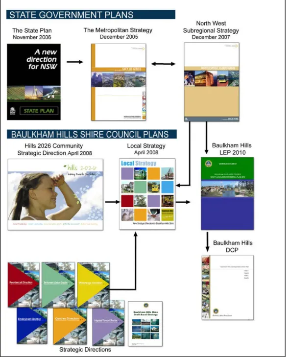
It is important to understand the context within which the Residential Direction operates, as shown in Figure 1.
A summary of relevant State Government programs and major Council projects is provided over the page.
Figure 1: Context of Residential Direction
Context
RESIDENTIAL DIRECTION
THE STATE PLAN
The State Plan was launched by the Premier on 14 November 2006 with the overall purpose being to deliver better results for the NSW community from government services.
The State Plan identifies 34 priorities under five broad areas of activity and sets targets, actions and new directions for each priority area.
The State Plan contains two targets relevant to the formulation of Council’s Residential Direction. The lead agency for these targets is the Department of Planning.
E5 Jobs closer to home
The target is to increase the percentage of the population living within 30 minutes by public transport of a city or major centre. In Sydney in 2005, 80 per cent of residents could access a city or major centre within 30 minutes by public transport. However, this varies by subregion with the North West subregion having only 59% of the population meeting the stated criteria.
Changes in the measure are likely to be seen as major new public transport infrastructure becomes available and as development occurs in release areas and growth centres.
For the North West subregion, it would be expected that some improvement would be seen in the measure in the short term with the commencement of the North West Transitway.
However, residential development in release areas ahead of the construction of North West Metro (2017) may mean that significant improvements in the measure are not seen for some time.
Continuation of Council’s current approach of providing redevelopment opportunities close to existing centres, public transport and employment areas and retention of low density housing areas will assist with addressing State Government targets.
E6 Housing affordability
The State Plan provides numeric targets for land and housing provision in the Sydney Metropolitan Region consistent with the objectives of the Metropolitan Strategy.
METROPOLITAN STRATEGY
The Metropolitan Strategy ‘Cities of Cities: A Plan for Sydney’s Future’ was launched by the Department of Planning in December 2005.
Sydney’s population is expected to grow by about 1.1 million people to a total of 5.3 million people, resulting in a need for an additional 640,000 new dwellings by 2031. In order to ensure an adequate supply of land and sites for residential development, the Metropolitan Strategy seeks to provide 30- 40% of new housing in land release areas and 60-70% of new housing in existing urban areas. This is to be achieved by the setting of subregional housing capacity targets.
Part C of the Metropolitan Strategy addresses Housing, with the vision being to ensure the supply of appropriate and well located housing with over three quarters of new housing located in centres and corridors within walking distance of shops, jobs and other services concentrated around public transport nodes.
Local government’s role in addressing the Metropolitan Strategy housing objectives
and targets:
• Consider sustainability criteria and infrastructure criteria for any additional release areas outside of the identified growth centres.
• Identify possible locations for additional housing.
• Provide for affordable housing and housing for seniors and people with a disability.
• Undertake housing market demand and supply analysis.
• Provide for improvements to the design quality of new developments.
• Provide for a mix of housing types near jobs, transport and services
High density residential development in Castle Hill
NORTH WEST SUBREGIONAL STRATEGY The North West Subregional Strategy provides implementation information for the Metropolitan Strategy. It was placed on public exhibition in December 2007.
The North West subregion consists of the Baulkham Hills, Blacktown, Blue Mountains, Hawkesbury and Penrith local government areas. By 2031 this subregion is to accommodate 130,000 new jobs and 140,000 new dwellings comprising 60,000 dwellings in the North West Growth Centre and 80,000 dwellings in existing urban areas and other release areas.
The target for Baulkham Hills Shire is an additional 36,000 dwellings by 2031. Of this 14,500 are identified for the North West growth centre and 21,500 are identified for existing urban areas and release areas such as Kellyville/Rouse Hill and Balmoral Road (NW C1.3.1 & NW C2.1.2).
Other than ensuring sufficient zoned land to accommodate housing targets and working with the State Government to review targets and facilitate development (NW C1.1.1, C1.4.1, C1.3.2), Councils role in addressing the North West Subregional Strategy actions in relation to housing includes:-
• Investigate opportunities for housing growth in the major centre of Castle Hill (NW C2.1.1).
• Consider proximity to public transport when planning for new dwellings to assist improvement against the target for State Plan Priority E5 ‘Jobs Closer to Home’.
Improvements in this area also rely upon timely delivery of State transport infrastructure and Council’s
Integrated Transport and Land Use Direction (NW C2.1.3).
• Undertake local housing market analysis to assist with reviewing zonings and planning controls to ensure a mix of housing. A market analysis forms part of the Residential Direction.
An action for the Department of Planning is to provide the METRIX planning tool to assist Councils in this area (NW C2.3.1 & C2.3.2).
• Continue to identify opportunities to renew local centres and facilitate renewal through planning for increased housing densities and improved public amenity. The precinct planning process for Baulkham Hills and Carlingford addresses this action (NW C3.1.1).
• Monitor the development of State Government options and initiatives in relation to improving housing affordability and assess the implications (NW C4.1.1 & NW C4.1.2).
• Ensure consultation with the Department of Housing regarding redevelopment and renewal of Department housing stock prior to the preparation of Local Environmental Plans (NW C4.2.1).
• Review Growth Centres Development Code to reflect best practice in development controls relating to design quality of new development and work with the Department of Planning to implement initiatives aimed at improving design quality (NW C5.1.2).
• Minimise household exposure to unacceptable noise levels (NW E2.5.1).
• Identify and implement measures to manage the interface between employment and residential land uses (NW A1.9.2).
• Identify and protect cultural heritage and manage change appropriately (NW E6.1.2, E6.2.1, E6.2.2, E6.3.1, E6.3.2).
Context
RESIDENTIAL DIRECTION
HILLS 2026 – COMMUNITY STRATEGIC DIRECTION
Hills 2026 Community Strategic Direction:
Looking Towards the Future identifies the Shire’s direction for the future and demonstrates how Council will align its delivery of services and facilities to support the direction. The preparation of Hills 2026 Community Strategic Direction involved an extensive community visioning and consultation process which indicated that one of the community’s biggest priorities is to manage urban growth to ensure that the right local balance is achieved.
Hills 2026 Community Strategic Direction documents Council’s commitments in relation to providing balanced urban growth. The Residential Direction will support Council’s commitments in Hills 2026, including:-
Encouraging a connected community;
Planning for sustainable, adaptable and affordable housing options;
Planning for employment, services and infrastructure to support housing areas;
Recognising and enhancing natural and cultural heritage; and
Enhancing and maintaining attractive streetscapes in keeping with the urban character.
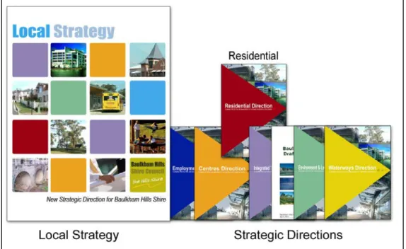
BAULKHAM HILLS SHIRE LOCAL STRATEGY
To build on the Hills 2026 Community Strategic Direction, a Local Strategy has been prepared. The Local Strategy is the principal document for communicating the future planning of the Shire in order to guide future decision making.
The Local Strategy is the key document articulating Council’s response to State plans and strategies and implementing key outcomes of the Hills 2026 Community Strategic Direction, within the context of land use planning in the Shire.
There are seven individual strategies relating to the key components of the natural and built environment, including:-
Employment Lands Direction
Centres Direction
Residential Direction
Integrated Transport Direction
Environment and Leisure Direction
Rural Lands Strategy
Waterways Direction
The Residential Direction, together with other strategy work, will inform the Local Strategy.
It is recognised that some aspects of the Residential Direction will overlap with other Directions, principally the Environment &
Leisure Direction, the Employment Lands Direction, the Centres Direction and the Integrated Transport Direction. Elements such as the growth of centres and employment areas, provision of public transport and protection of environmental qualities all impact upon how residential development is planned and managed for the future. The Residential Direction will support, but not replicate, the strategies and actions contained in the other Directions.
Our Vision
Resilient leadership creating vibrant communities balances urban growth protecting our environment and building a modern local economy
BAULKHAM HILLS LOCAL ENVIRONMENTAL PLAN
Baulkham Hills Council is required to prepare a new LEP in accordance with the State Government’s Standard Instrument – Principal Local Environmental Plan by March 2011. The LEP will reflect Council’s desired strategic direction for residential development. The Residential Direction will inform the LEP zonings, objectives and clauses and will guide future land use zonings.
The Standard Template prescribes a number of different zones with set objectives, permissible and prohibited uses, standard definitions, and special clauses. The following zones are relevant to the Shire’s residential areas:-
R1 General Residential
R2 Low Density Residential
R3 Medium Density Residential
R4 High Density Residential
R5 Large Lot Residential
B4 Mixed Use
E4 Environmental Living
BAULKHAM HILLS DEVELOPMENT CONTROL PLAN
Baulkham Hills Development Control Plan provides detailed controls to direct development within the Shire. The Residential Direction will inform the drafting of the Baulkham Hills Development Control Plan to respond to residential development issues such as encouraging development uptake, protecting streetscape and character and improving quality of design.
Figure 2: Context of Residential Direction
Context
RESIDENTIAL DIRECTION
1997 RESIDENTIAL DEVELOPMENT STRATEGY
Council’s 1997 Residential Development Strategy was the means by which Council demonstrated the Shire’s contribution towards the achievement of the wider metropolitan planning objective of increasing multi unit housing in areas well served by transport and human service facilities. The Strategy was finalised in February 1997 and included an urban capability assessment and a residential traffic study.
The urban capability assessment examined a number of factors including traffic, public transport, drainage, access to employment, access to services, open space provision, demography, geology/soils, heritage and significant vegetation.
Key findings of the assessment were:
Strong population growth in the order of 4- 6% per annum;
Changing housing and family
characteristics resulting in a shift in demand from traditional single dwellings to smaller, multi unit dwellings;
One of the highest car ownership rates in the Sydney metropolitan area; and
Congested arterial road system, affecting the capacity of the Residential 2(a) areas to accommodate further intensification of development.
The findings of the assessment pointed to the need to manage unrestrained growth by a planned and deliberate strategy designed to make best use of scarce resources and provide a framework for certainty in investment and lifestyle aspirations. The strategy arising from the assessment aimed to focus high density development in those precincts which had shown a capacity to accommodate further growth.
This approach resulted in the identification of several precincts and sites as suitable for medium and high density multi-unit development and subsequent rezoning of several different areas in the Shire to Residential 2(a1), 2(a2) and 2(a3) in November 2001. A total of 16 target sites were identified as suitable for development at higher densities and in need of site specific development requirements.
The Residential Direction reviews achievements under this Strategy as a starting point to determining the remaining dwelling potential for established parts of the Shire.
Gilroy College Target site under construction
Methodology
RESIDENTIAL DIRECTION
The Residential Direction has been prepared based on a review of existing Council and State Government planning policies, stakeholder consultation, and on an opportunities and constraints analysis. Such analysis included assessment of existing planning controls and determination of housing potential.
The methodology for determining residential capacity included a desktop review of achievements under Council’s 1997 Residential Development Strategy. This provided an indication that there was capacity for further gains under the current framework to 2031.
The remaining potential has been further refined through investigation of sites available for future development and consideration of current projects or changed circumstances such as Carlingford precinct planning, Baulkham Hills Town Centre Development Control Plan and changes to target site potential.
A Demographic and Housing Market Analysis was undertaken by Elton Consulting and finalised in February 2008. The aim of the Analysis was to provide guidance for the formulation of the Residential Direction by profiling demographic, economic and social characteristics; identifying key drivers influencing housing need; assessing future impact of trends on housing need and demand and; identifying key issues to be addressed when planning for residential development.
A Residential Character Analysis was undertaken in 2007 to determine the existing residential character and streetscapes in the Shire, assess the impacts of new residential development on these streetscapes and recommend an approach for addressing such impacts in the future. This Analysis included:
• Investigation of the lower density residential areas of the Shire to determine and document key components of character and streetscape;
• Market review to determine which areas are sought after, and what makes these areas attractive to buyers;
• Examination of existing planning controls relating to character/ streetscape and how these are interpreted and implemented; and
• Review of relevant development controls used by other Councils.
The Direction has taken a whole of Council approach to achieving residential development that meets the needs of the community and the environment. To this end, briefings and consultation has been undertaken across all areas of Council to assist in understanding community concerns, clarifying housing issues and refining directions to be pursued.
The Residential Direction has been prepared based on these investigations and analysis. It has been publicly exhibited and feedback sought from external stakeholders such as government departments, infrastructure providers, other Councils and other interested parties.
Following consideration of feedback, the document was amended and reported to Council for adoption in June 2008. The Direction will be used to assist with the drafting of the residential components of LEP 2010 and ongoing strategic direction.
Methodology
RESIDENTIAL DIRECTION
Key documents reviewed during preparation of the Residential Direction:
• Baulkham Hills Shire Demographic and Housing Market Analysis, 2008
• Baulkham Hills Shire Housing Strategy, 1995
• Baulkham Hills Shire Housing Study, 1994
• Baulkham Hills Shire Residential Character Analysis, 2007
• Baulkham Hills Shire Residential Development Strategy, 1997
• Carlingford Precinct Plan (Draft), 2005
• Carlingford Precinct Plan Review of Urban Design Development Controls, 2006
• Cultural Plan for Baulkham Hills Shire 2005-2010
• Framework for National Action on Affordable Housing, 2005
• Growth Centres Development Code, 2006
• Hills 2026 Community Strategic Direction (Draft), 2008
• Local Government Affordable Housing Strategy, 2005
• Metropolitan Strategy: City of Cities: A Plan for Sydney’s Future, 2005.
• North West Subregional Strategy (Draft), 2007.
• NSW State Plan, 2006.
• Review of Housing for Aged and Disabled Persons within Baulkham Hills Shire, 2003
• State Environmental Planning Policy No.
65 – Design Quality of Residential Flat Development
• State Environmental Planning Policy (Housing for Seniors or People with a Disability) 2004
• Urban Capability Assessment of Residential 2(a) Zones in Baulkham Hills, 1999
Duncraig Estate, Kellyville
Structure Plan
RESIDENTIAL DIRECTION
A Structure Plan supports the findings and key directions of the Residential Direction. It illustrates where residential growth will occur over the next twenty five years.
The Structure Plan and the Castle Hill Plan (Figure 13) are intended to be conceptual in nature, and are provided to communicate residential development that currently exists in the Shire and future directions that are anticipated. The Structure Plan is not a zoning map.
In order to provide the strategic planning context for residential development, the Structure Plan is based on the urban part of the Shire and shows:
• the hierarchy of current and planned centres.
• existing and planned residential growth, including the North West Growth Centre, Balmoral Road Release Area and Rouse Hill.
• existing and planned areas of higher density residential development.
• existing and planned public transport such as the North West Metro, strategic bus corridors, the North West Transitway and transport interchanges.
• existing and proposed open space including State reserves, regional parks and local open space used for purposes such as public recreation, drainage or conservation.
The Structure Plan also highlights areas where Council will need to undertake more detailed planning in the future, such as railway station precincts and review of residential development opportunities in parts of Castle Hill, Oatlands, Northmead and Winston Hills.
Two target sites are also identified for review being land at Mason Drive North Parramatta and land at the Bull and Bush Hotel at Baulkham Hills.
•
Disability) 2004
• Urban Capability Assessment of Residential 2(a) Zones in Baulkham Hills, 1999
Findings
RESIDENTIAL DIRECTION
The overall analysis process highlighted a range of housing issues requiring strategic responses. This section of the Direction sets out the findings of the analysis which underpin the formulation of strategies for residential development in the Shire.
DWELLING ACHIEVEMENTS
At Census 2001, there were 46,255 dwellings in the Shire. This increased by 8,114 dwellings (or 17.5%) to 54,369 dwellings by Census 2006.
Release Areas
The majority of this development occurred in the Kellyville/Rouse Hill release area which, once complete, will accommodate about 14,000 dwellings. Development potential remains for approximately 3,400 dwellings in this area predominately comprised of higher density development in Rouse Hill centre and Norwest.
The Balmoral Road release area was rezoned for urban purposes in April 2006 and is expected to accommodate about 6,000 dwellings by 2021. Future residential releases are planned for North Kellyville and Box Hill as part of the implementation of the North West Growth Centre. North Kellyville is a first release precinct and will provide about 4,500 dwellings by 2024. Box Hill is not in the first stage release however it is ultimately expected to provide about 10,000 dwellings.
Established Areas
A significant component of the residential growth since 2001 was due to high and medium density development close to centres.
Such growth followed the implementation of the 1997 Residential Development Strategy which resulted in the rezoning of several areas in 2001 to produce a hierarchy of high and medium density zones and targeted 16 sites for development at higher densities.
Since 2001, approximately 2,670 dwellings have been approved or constructed under the hierarchy of zones. Of these, 68% (1,810 dwellings) have been in the Residential 2(a1) zone, 22% (600 dwellings) have been in the Residential 2(a2) and 10% (260 dwellings)
have been in the Residential 2(a3) zone as shown in Figure 3.
New Rouse Hill
0 500 1000 1500 2000 2500 3000
APARTMENT ZONE TOWNHOUSE
ZONE VILLA ZONE
2(a1) 2(a2)
2(a3) TOTAL
Figure 3: Dwellings by Zone 2001 to 2006
Figure 4: Dwellings by Zone and Locality 2001 -2007 After ten years of implementation, a review of
the current hierarchy of zones in established areas is warranted. Development has been focused around the centres of Castle Hill, Baulkham Hills and Carlingford Station as shown in Figure 4 below.
In Castle Hill the majority of sites zoned and suitable for apartments have already been developed or have had consent granted, illustrating the high uptake of the opportunity for this form of residential development.
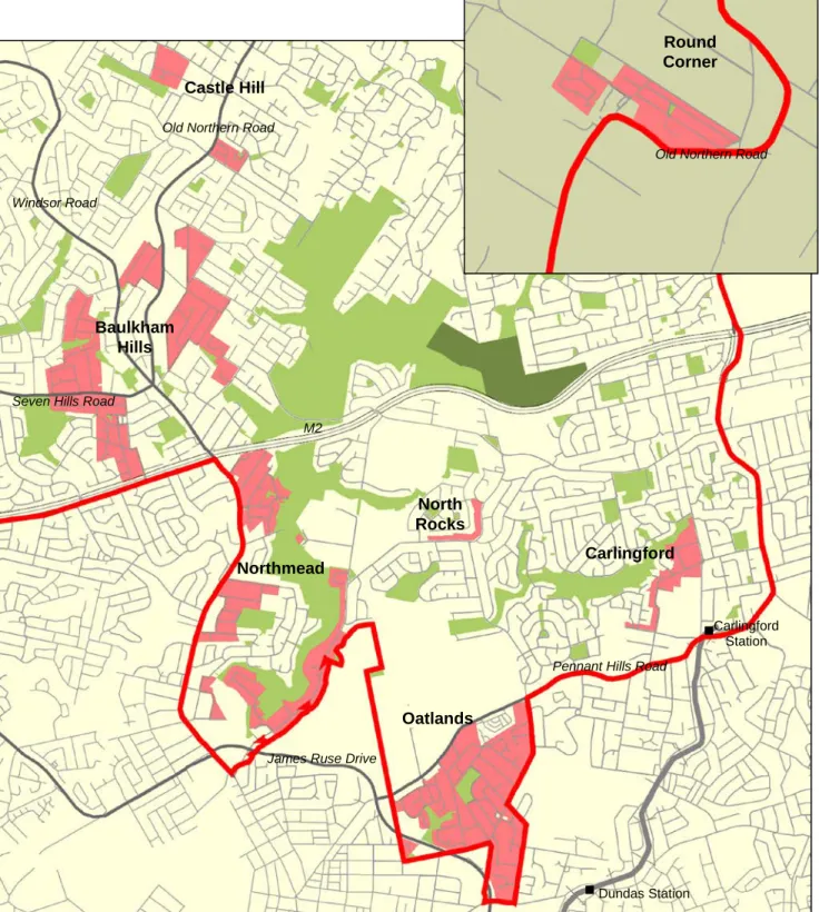
There has been slow uptake of opportunities for villa housing development in Residential 2(a3) zoned areas. These areas include parts of Oatlands, Carlingford, North Rocks, Baulkham Hills and Dural as shown in Figure 5. Such areas are not located within the same proximity to centres and transport as higher density residential zones.
The Template LEP does not provide for a similar ‘villa housing’ type zone, therefore, it is timely to review whether land currently zoned 2(a3) is suitable for higher density housing.
Whilst the need for diversity of housing choice and affordable options is recognised, key factors in determining suitable locations for higher density housing are proximity to jobs, transport and services and the need for suitable transitions from more intense uses.
Based on such factors it is unlikely that all of the current 2(a3) zoned land will be suitable for higher density housing. Further review is required of suitable locations.
Findings
RESIDENTIAL DIRECTION
Figure 5: Land zoned Residential 2(a3) to allow villa housing
Oatlands Northmead
Baulkham Hills
North Rocks
Carlingford Castle Hill
Round Corner
Carlingford Station
Dundas Station M2
James Ruse Drive
Pennant Hills Road Windsor Road
Old Northern Road
Seven Hills Road
Old Northern Road
There is significant remaining development potential in the Residential 2(a1) and 2(a2) zoned parts of the established areas. This potential has been enhanced in recent years by Carlingford precinct planning and Baulkham Hills town centre planning.
Carlingford Precinct is ideally positioned for urban renewal due to its central location within the Sydney Metropolitan Area, access to public transport, age of dwelling stock and significant land holdings by developers.
Proposals for higher density development in this area could achieve an additional 3000 dwellings.
Proposals for Baulkham Hills town centre seek to promote the revitalisation of the town centre by accommodating the expansion of retail, commercial and residential development within a setting that promotes pedestrian movement, public transport and an improved public domain. The Masterplan for this area suggests potential for up to 500 residential units in and adjacent to the town centre.
The achievement of this potential depends on whether the market is able to acquire the required land area and if developers are willing to construct mixed use buildings. Whilst the Development Control Plan for the town centre has been prepared on the basis of encouraging residential uses, a minimum allotment size of 4000m2 for apartment development applies, which may not be easily acquired. Review of development controls is recommended to facilitate take-up of this housing option.
Target Sites
In relation to target sites, five of the 16 sites have been developed or had consent granted for residential development, resulting in approximately 450 additional dwellings to date.
Four of the sites no longer have potential for residential development due to alternative development proposals being pursued by the owners of these sites, for example the Bunning’s Warehouse site at North Parramatta.
There is remaining potential for residential development on seven target sites. Some of these have proceeded to preparation of Development Control Plans or development
applications indicating a relatively high level of certainty. In other cases there has been no interest expressed in pursuing the residential potential. This could be due to a number of reasons such as cost, lack of viability or the desire to retain the land for other purposes.
Baulkham Hills Town Centre It is noted that the target sites process is dependant on the owner initiating and funding preparation of a site specific Development Control Plan. Where this process has not been initiated, review is required of the viability and appropriateness of such sites to determine whether they should remain on the target site program. Two sites are identified for review, at Mason Drive North Parramatta and the Bull and Bush Hotel at Baulkham Hills, and are shown on the Structure Plan map.
The likely yield from remaining target sites is in the order of 825 dwellings. These are generally located within or close to centres. In this Direction and Structure Plan, potential dwellings for target sites are included with the dwelling figures for established areas.
Findings
RESIDENTIAL DIRECTION Delivery of Development
It is important to recognise that the zoning of land to accommodate development may not by itself lead to significant development.
Impediments to residential development can include:
• Macroeconomic conditions and policies which can impact on housing demand and cost.
• Lack of viability for some forms of development relating to land costs, construction costs, fees and charges, market conditions, and unrealistic vendor expectations.
• Fragmented land ownership which inhibits orderly development.
• Limited infrastructure capacity or timing of delivery of infrastructure such as the North West Metro.
• Competing priorities for commercial or retail development close to centres.
When faced with such factors, there are limited options for Council to encourage timely delivery of residential development.
Planning controls can be reviewed where it is demonstrated this is a key factor in slow rates of development. Council can also play a role in identifying and lobbying for State level infrastructure to assist the development of land release sites on the Metropolitan Development Program such as Balmoral Road Release Area.
Proposed route North West Metro. Source: SydneyLink Discussion Paper 2008
HOUSING NEEDS
A Demographic and Housing Market Analysis has been completed which identifies existing and likely future housing issues for the Shire. It has indicated some key demographic and affordability trends that will impact on housing needs and demand into the future. Research of group homes has also been undertaken.
Demographic trends
• Smaller household sizes
The average size of households in Australia has been falling for the last 30 years and is expected to fall further in the future. This trend has not been as marked in Baulkham hills where the current average occupancy rate is 3.15 persons per dwelling, reflecting a high level of migration of family households into the Shire. In the longer term however, it is projected that the average household size will decline to about 3 persons per dwelling.
Whilst this factor is not likely have an immediate impact (given the tendency to acquire larger homes than needed), there is likely to be a gradual increase in demand for smaller homes especially if affordability continues to decline.
• Increasing household diversity
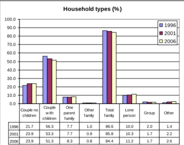
Changes in household composition have been gradual but trends are clear as shown in Figure 6.
Household types (% )
0.0 10.0 20.0 30.0 40.0 50.0 60.0 70.0 80.0 90.0 100.0
1996 2001 2006
1996 21.7 56.3 7.7 1.0 86.6 10.0 2.0 1.4
2001 23.9 53.3 7.7 0.9 85.8 10.3 1.7 2.2
2006 23.9 51.3 8.3 0.8 84.4 11.2 1.7 2.6
Couple no children
Couple w ith children
One parent
family Other family
Total family
Lone
person Group Other
Figure 6: Change in Household Composition 1996-2006
Decline in the proportion of family households and increases in the proportion of single people and couples without children will increase the demand for a wider variety of dwelling types in the future. Location will be critical, with demand likely to continue to focus around main centres.
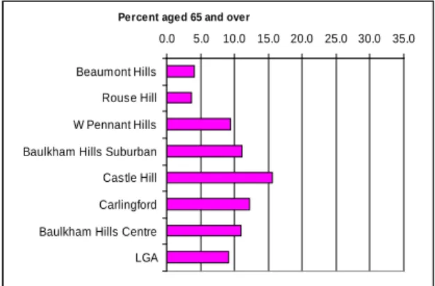
• Increasing ageing population
It is well known that life expectancies are increasing and the proportion of older people in the population is increasing. In this Shire, the proportion of persons aged 65 and over rose from 7.6% to 9.1% in the decade 1996- 2006.
Figure 7 provides an indication of the distribution of older residents in the Shire, with higher proportions in the established parts of Castle Hill, Carlingford and Baulkham Hills.
Percent aged 65 and over
0.0 5.0 10.0 15.0 20.0 25.0 30.0 35.0 Beaumont Hills
Rouse Hill W Pennant Hills Baulkham Hills Suburban Castle Hill Carlingford Baulkham Hills Centre LGA
Figure 7: Distribution of older residents in the Shire The issue will become increasingly significant over time as people who settled in new suburbs reach retirement age.
A choice of housing that suits older people will be important in the future with demand likely to be for options including good quality small lot and medium density homes in accessible locations, purpose built housing and dwellings that can be adapted if the mobility of residents decreases.
State level strategies to address the issue of housing for aged and disabled persons include State Environmental Planning Policy (Housing for Seniors and People with a Disability) 2004 and North West Subregional Strategy NW C2.2.1 which requires the Department of Planning to consider provisions for seniors and people with a disability in the Standard Instrument which will then be reflected in each Principal LEP.
Findings
RESIDENTIAL DIRECTION
At the local level, Council has sought to provide for a range of dwelling types in the Shire. The Baulkham Hills Development Control Plan as it relates to Dual Occupancy, Villa Housing, Townhouses and Apartment Buildings, includes provisions that encourage adaptable and accessible housing so as to accommodate residents who may have special needs, or declining mobility or sight.
In addition, Council has adopted Making Access for All 2002 which are guidelines that seek to raise the profile of the needs of people with a disability and provide for appropriate and improved access and facilities for people who are mobility impaired.
An examination of the current supply of housing indicates that constructed and approved specific aged care accommodation comprises approximately:
• 1280 self care units
•
725 hostel/ nursing home bedsBased on this figure, self care units comprise approximately 2.3% of the housing stock in the Shire.
• Loss of young adult residents
The different age profile of the Shire compared to the Sydney Region in 2006 is shown in Figure 8.
Age profile (% )
0%
1%
2%
3%
4%
5%
6%
7%
8%
9%
0-4 10-
14 20-
24 30-
34 40-
44 50-
54 60-
64 70-
74 80-
84 90-
94 100+
LGA Sysney SSD
F igure 8: Baulkham Hills Shire Age Composition
compared with Sydney Region 2006
This indicates that the Shire has a far lesser proportion of young adults than the Sydney Region. This reflects the tendency for local young people to leave the area at some stage between the ages of 20-30.
Whilst not simply a housing issue, it is likely that a wider variety of affordable accommodation options will mean fewer young adults leaving the Shire. The retention of young adults especially, if they live in the main centres, will boost the appeal of these locations, further increasing demand for diversity of housing and also contributing to the vibrancy of centres.
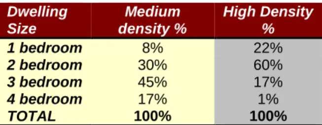
An analysis has been undertaken of the mix of dwelling size for medium and high density development constructed or approved in recent years. The findings are set out in Figure 9.
Dwelling Size
Medium density %
High Density
%
1 bedroom 8% 22%
2 bedroom 30% 60%
3 bedroom 45% 17%
4 bedroom 17% 1%
TOTAL 100% 100%
Figure 9: Mix of dwelling size since 2001
This table indicates a predominance of two and three bedroom medium density dwellings and two bedroom high density dwellings.
Strategies should focus on achieving a sufficient new supply of smaller dwellings to address the longer term demographic trends.
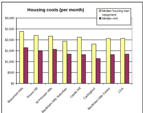
Housing affordability
Housing affordability is concerned with households having access to housing that is appropriate to their needs and within their means to pay for it. The median monthly housing loan payment in the Shire is $2062 compared to $1800 in the Sydney Region. The median rent, at $320 a week, is also higher than the Sydney Region average of $250. The variation in costs across different parts of the Shire is shown in Figure 10.
A commonly used measure of affordability is the cost of housing in relation to gross household income i.e. households in the lowest 40% of the income range are said to be in “housing stress” if they are paying more than 30% of their gross income on housing costs (rent or loan). The ABS map at Figure 11 shows the percentage of households spending over 30% of their income on housing.
Housing stress has become a fact of life for many households, especially first home buyers and renters and affordability is a major issue for all levels of government.
Over the years there have been a number of State and Federal responses to this issue including the Framework for National Action on Affordable Housing in 2005, the Department of Housing Local Government Affordable Housing Strategy and State Policies for specific issues such as group homes, low cost rental accommodation, caravan parks and seniors living.
State Environmental Planning Policy No. 10 Retention of Low Cost Rental Accommodation was gazetted in 1984 and aims to retain existing sources of low cost accommodation such as boarding houses, hostels and low cost rental dwellings. Statistics on the number of such dwellings in the Shire are not readily available. The maintenance of a register of SEPP 10 development will enable Council to undertake long term monitoring on the supply and retention of this form of affordable housing.
Notwithstanding the range of responses, a clearer Federal and State Framework is needed to facilitate Council response to affordable housing. Actions for the NSW Government have been identified in the North West Subregional Strategy.
Issues of particular relevance in Baulkham Hills include the following:
• Rental affordability is much better than purchase affordability as shown in Figure 10.
• In general, areas that include some older- style accommodation, especially older flats, tend to offer more affordable options than areas of new housing. Thus, centres like Carlingford offer better than average affordability.
• Provision of subsidised social housing is minimal in most recently developed areas, due to funding constraints on public and community housing.
Housing costs (per month)
$0
$500
$1,000
$1,500
$2,000
$2,500
$3,000
Bea umont Hills
Rous e H
ill
W Pennant Hills
Bau lkham
Hills Subu rban
Castle Hill Carlingf
ord
Bau lkham
Hills Centre LGA Median housing loan repayment Median rent
Figure 10: Housing loan and rent costs in the Shire 2006 Lack of housing affordability increases the demand for rental accommodation, reduces the capacity for first time buyers to enter the market and increases demand for higher density housing (so long as it is more affordable than traditional housing).
Anecdotal evidence indicates that requests to Hills Community Aid for financial assistance have increased in recent years as a result of people struggling to pay mortgage or rental costs.
Group Homes
Consideration also needs to be given to the accommodation of disabled or socially disadvantaged people. State Environmental Housing Policy No. 9 Group Homes was gazetted in 1983 to ensure a sufficient supply of accommodation for these groups. The provisions of this SEPP have since been included in State Environmental Planning Policy (Infrastructure) 2007. Statistics on the number of transitional and permanent group homes are not readily available given that smaller developments do not require consent.
Preliminary investigations indicate that there are approximately 18 group homes in the Shire ranging from single dwellings to larger developments such as Burnside Homes at Oatlands or McCall Community Gardens at Box Hill.
Since 1998 the NSW Government has committed to closing large residential centres for people with a disability and relocating people to community based accommodation.
Therefore it is likely that demand for this form of accommodation will continue to grow. A strategic approach is required to obtain a clear picture of the supply and demand for this form of housing in the first instance.
Findings
RESIDENTIAL DIRECTION
Figure 11: Percentage of households spending over 30% of household income on rent or mortgage payments, 2006.
This map shows that the areas where residents use more than 30% of their household incomes for housing costs are the release areas and the centres of Baulkham Hills, Castle Hill, Carlingford and Dural.
The map data needs to be interpreted with care, as the map covers all income groups.
Therefore households in higher income groups
may be paying a large percentage of their income on their housing but may still have adequate funds left over to cover their other needs comfortably. Additionally, home ownership is a form of investment, and some households voluntarily allocate a large percentage of income to their home loan.
SUSTAINABILITY
A key focus of the Residential Direction is to provide ‘sustainable living’ for the residents of the Shire in terms of economic, community and environmental outcomes. Economic or affordable housing outcomes are addressed as part of the housing needs analysis.
Findings in relation to community and environmental sustainability measures are set out below:
Community Sustainability
A sustainable community is one that has strong social networks supported by a range of facilities, services and local business and can also provide the labour force to deliver these activities. Encouraging a connected community is a key theme of the Hills 2026 Community Strategic Direction. Council also has in place a Cultural Plan for 2005-2010 which includes a principle of creating liveable and inspiring places which invite community ownership and enhance community identity.
Actions identified to achieve such outcomes relate to development of ‘place making’ tools and implementation of projects.
‘Place making’ is about engaging and involving the community to build consensus about the design and development of distinct places which invite community ownership. This process is most effective when undertaken early in the urban development process as it facilitates community understanding and provides a network for ongoing engagement and issues resolution.
This process is a type of social research and will inform land use planning, community planning and delivery of works and services.
Therefore a multidisciplinary approach is required to facilitate successful engagement, integration with plans and policies of Council and implementation of outcomes. To this end Council is committed to the Just Communities project which will assist with refining the process and methodology, in the first instance.
In terms of land use planning, the Environment and Leisure Direction and Integrated Transport Direction seek to improve the accessibility and connectivity of spaces and provide public domain spaces that encourage community interaction. Strategies and actions identified in
these Directions will assist with providing the physical framework for community connection.
The Baulkham Hills Development Control Plan generally seeks to integrate buildings and landscaped areas to add to the neighbourhood character and provide high levels of amenity and safety for future residents. Development controls for higher density residential development include provision of cycle links and common open space areas.
Development controls for specific sites and precincts also have public domain objectives For example, one of the desired planning outcomes for Baulkham Hills town centre is a vibrant town centre with a focal point for community facilities, cultural events and leisure activities.
As the community becomes more involved in defining the desired characteristics of distinct places it is likely that development controls will require further review.
Environmental Sustainability
Environmental sustainability is concerned with protecting the natural environment, containing environmental impacts and reducing reliance on non-renewable resources.
State Environmental Planning Policy No. 19 – Bushland in Urban Areas seeks to protect bushland and ensure that bush preservation is given a high priority when LEPs for urban development are prepared. Given the extent of the interface between urban land and bushland there are associated risks of bushfire. There is a need to balance housing needs and bushfire protection requirements with environmental objectives. Consideration must be given to the provisions of SEPP 19 and relevant Section 117 direction 4.4 Planning for Bushfire Protection when drafting LEP 2010.
The research undertaken for the Residential Direction highlighted the following focus areas relating to residential development as needing further investigation: dwelling construction, amenity issues and heritage conservation.
Findings
RESIDENTIAL DIRECTION
• Dwelling Construction
The Building Sustainability Index (BASIX) system introduced in July 2004 is the primary regulatory tool to achieve sustainability within new homes in NSW. BASIX is an on-line internet-based tool that aims to achieve a reduction in dwelling-related greenhouse gas emissions by targeting water and energy usage for homes.
BASIX certificates must accompany all development applications for all new residential dwellings, including single dwellings, villas, townhouses and apartment developments in NSW (including alterations and additions), and are submitted to Council at the time of lodgement.
BASIX takes into consideration factors such as dwelling orientation and size, building materials, external shading devices, insulation, cross ventilation, window placement and natural lighting, the installation of energy efficient fittings (lights, showers, toilets etc), and landscaping.
Whilst BASIX has achieved some developer awareness and improvements for new dwellings, further improvements could be made. The options are limited however, given that the BASIX system restricts Council from introducing planning controls that contain more strict sustainability criteria. Also, there is currently no regulatory framework to make existing dwellings more efficient. Strategic responses therefore, need to focus on education and advocacy in order to promote further improvements.
Source:www.basix.nsw.gov.au/information/common/pdf/basix_sustainable_house.pdf
• Amenity issues
The North West Subregional Strategy includes an action for the Department of Planning to work with Councils in identifying and implementing measures to manage the interface issues (such as noise and access) between employment and residential uses (NW A1.9.2) It indicates that approaches will be considered through the Employment Lands Development Program and Employment Lands Ministerial Advisory Committee.
Additionally, the Department of Planning, Department of Environment and Climate Change, Roads and Traffic Authority, Ministry of Transport and NSW Health are developing guidelines for development along busy roads which are to be considered by Council when planning for future housing (NW B7.2.2).
An additional action of the North West Strategy requires Council to identify and consider major noise sources in preparing the principal LEP. The potential major noise sources for the Shire are classified roads, bus transitways and the existing and proposed rail lines.
Residential amenity is most appropriately protected by suitable separation of incompatible uses. Within the Shire, noise issues arise where there is conflict between commercial and residential uses and urban and rural uses. Vehicle and rail movements along major transport routes also have significant noise impacts.
Current controls in Council’s LEP 2005 require a noise and vibration assessment and appropriate measures for development on land within 100 metres of a classified road or bus transitway. Additionally, consent cannot be granted for development on land within 60 metres of the North West Rail Corridor unless Council is satisfied that the proposal incorporates appropriate noise attenuation and vibration minimisation measures.
Under Baulkham Hills Development Control Plan an acoustic report is required for development applications where:- significant noise will be created; a significant amount of traffic will be generated; or the new development is noise sensitive and located where there are existing noise sources.
For residential development, development controls seek to ensure acoustic privacy for residents. For dwellings that adjoin classified
roads, dwellings are to be designed to acceptable internal noise levels, based on Australian Standard AS3671 – Road Traffic Noise Intrusion Guidelines.
Anecdotal evidence indicates that difficulties can be experienced by individual home owners faced with these noise attenuation requirements.
Amenity impacts such as noise, loss of privacy and overshadowing can also arise in relation to adjoining residential development. This can be problematic where development is proposed on corner allotments and battleaxe allotments.
For corner allotments, the location for dwelling construction may be limited due to the required setbacks from the road. For battleaxe allotments, the location for dwelling construction may be limited by the area required for vehicle manoeuvring and irregular shaped allotments. Two storey dwelling construction is often favoured by the owners to address such constraints which is likely to have greater impacts on the amenity of adjoining properties.
Overall there is opportunity to rationalise and improve development controls to provide for more effective management of land use conflicts. Proposed strategies are discussed in Key Direction R3.
• Heritage Conservation
Conserving our built heritage contributes directly to sustainability practice and can achieve energy savings and reductions in greenhouse gases and waste generation.
A comprehensive Shire-wide Heritage Study was undertaken in 1993. This was in response to development pressures and the demise of previously unrecognised heritage properties, and led to the addition of more than 100 new heritage items to Council’s LEP.
Heritage items are varied and widespread throughout the Shire and comprise of approximately 260 sites and items. They include churches, residences, slab huts, inns, fences and gates, burial grounds, convict built structures, roads, school and police buildings.
Council currently seeks to conserve the heritage significance of items and heritage conservation areas via both regulatory and non-regulatory measures.
Findings
RESIDENTIAL DIRECTION
Local Heritage Item - Bellerive Castle Hill
Section 117 Direction 2.3 Heritage Conservation requires that draft LEPs shall include provisions that facilitate the conservation of items, areas, objects and places of environmental heritage significance.
Consideration must be given to the provisions of this Direction when drafting LEP 2010.
Regulatory measures include heritage conservation provisions which detail when consent is required, the requirements for a heritage impact statement and in some cases a Conservation Management Plan.
Conservation incentive provisions allow for uses that would not otherwise be allowed, subject to a number of conservation and amenity criteria.
One non regulatory measure used by Council is the Heritage Assistance Fund which was established in 2001. Owners of heritage items are invited to apply for funding on an annual basis. The total available for allocation each financial year was increased from $20,000 to
$30,000 for 2008/2009. The maximum level of funding per project is limited to $2,000 and is subject to the owner providing at least matching finance for the projects.
Other non regulatory measures relate to providing heritage information to landowners, the community and special interest groups.
This includes information on Council’s website, a biannual Heritage Happenings newsletter, Heritage fact sheets, information on specific heritage projects such as the Convict Trail Project and contact information for the NSW Heritage Office and local historical societies.
Notwithstanding these measures, development pressures can lead to the loss or demise of heritage items. In release areas particularly, subdivision pressures can compromise the protection and management of heritage items. A strategic approach is required to improve existing measures and implement new measures to retain and improve items of heritage significance in the Shire. Proposed strategies are discussed in Key Direction R3.
Funding provided to complete conservation works at St Elmo Dural
QUALITY OF DEVELOPMENT
Key findings of the 2006/2007 Baulkham Hills Shire Council Community Survey reflect community concern in relation to how higher density housing impacts on the ‘look and feel’
of the Shire. Design quality of residential development is about more than the appearance of buildings - it is about the creation of urban places that are safe, liveable, functional and diverse and encourage a sense of community identity and ownership.
Residential Character and Streetscape Currently many parts of the Shire are undergoing change and revitalisation as existing housing stock makes way for newer dwellings. The new housing does not always sympathetically relate to the existing streetscape and surrounding development, with many areas at risk of losing the characteristics that make an area unique or desirable.
The residential character of an area is defined by the urban design elements used to create the built environment such as its topography, setting, land uses, open space, heritage, and elements of the street (including architecture, spatial separation, lot size, street typology, setbacks, bulk and scale, colour and materials).
A Residential Character Analysis undertaken in 2007 revealed that the Shire’s older suburbs including North Rocks, Oatlands, Northmead, and Carlingford have an established character that reflects a history of development. There is increasing renewal of conventional housing stock occurring in these areas where new housing, often ‘knock down rebuild’ projects, does not reflect the existing built form, character and streetscape. This process of renewal is due to a range of factors such as increasing land prices, existing housing stock ending their economic life and the changing needs and aspirations of households and the community.
New development in established areas Currently, Development Control Plan objectives seek to encourage developments that sympathetically relate to adjoining developments and that add to the character of the neighbourhood. However, the development controls are not all measurable on numeric terms and implementation often relies on a more subjective assessment.
Observation of the urbanised parts of the Shire and investigations of the housing markets has revealed that whilst there is no dominant architectural style in the majority of the established area, there are streetscape elements worth protecting to maintain the garden character of the Shire.
The Mill Drive and Perry Road precincts in North Rocks have been identified as having a distinct character.
Perry Road Mill Drive
Findings
RESIDENTIAL DIRECTION
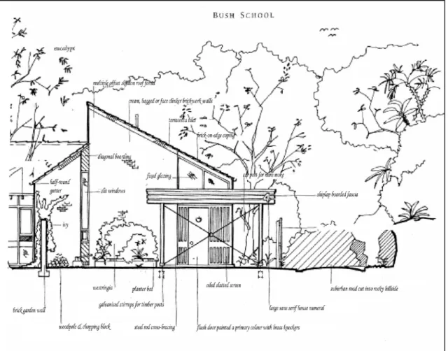
This is because there is a consistency and strong representation of urban design and streetscape elements such as:
• architectural style (Bush school architecture circa 1970 as shown in Figure 12)
• detached garages
• steep slopes and bushy sites
• use of natural materials
• skillion roof forms
• single narrow driveways
• retention of native vegetation
Dwellings have generally been designed to integrate with the site and the surrounding environment as shown over the page. This area would require specific design controls to protect and enhance the bush architecture character.
Figure 12: Elements of Bush School Architecture Source: Stapleton. 1997
Typical streetscape in Mill Drive precinct North Rocks
The Residential Character Analysis has identified a number of changes that can be made to development controls to mitigate the impacts of new development and protect the unique character of certain areas.
Design quality of higher density development
The design quality of apartment building development is assessed under the provisions of SEPP 65 Design Quality of Residential Flat Development and Council’s Multi Unit Urban Housing Design Guidelines.
Design principles are set out in SEPP 65 Design Quality of Residential Flat Development which was prepared by State Government in July 2002. These principles relate to context, scale, built form, density, use of resources, landscape, amenity, safety, social dimensions and quality aesthetics. The policy seeks to provide a guide as to what constitutes good design and appropriate responses.
For apartment buildings Council reinforces the provisions of SEPP 65 and requires the consideration of Council’s Multi Unit Housing Urban Design Guidelines. These guidelines are also required to be considered for villa housing and townhouse developments. The guidelines were adopted in September 2001 and amended in November 2005. They identify the desired future residential character of certain planning precincts. For the
development of target sites identified under the 1997 Residential Development Strategy, an urban design review has been undertaken by a panel of architects/planners/urban designers.
The North West Subregional Strategy identifies a role for Councils to reflect best practice for design quality established by the Growth Centres Development Code (NW C5.1.2) for release areas outside the North West Growth Centre. The Development Code was produced by the Growth Centres Commission in October 2006 to guide the planning and urban design of precincts and neighbourhoods.
Castle Hill Library, incorporating apartment development
Findings
RESIDENTIAL DIRECTION
By working with the Growth Centres Commission for the North Kellyville precinct, Council will be in a position to evaluate the suitability of these measures and controls for other residential development in the Shire.
The North West Subregional Strategy also identifies a series of actions for the Department of Planning to improve design quality in new development. This includes providing educational material, expanding SEPP 65 to include medium density housing, developing centre design guidelines for areas undergoing renewal, identifying landmark sites and instituting processes to promote excellence in design.