After review of the submissions, some post-exhibition changes to the planning proposal are recommended, as described in Section 5(a) of this report. Comparison of the approved master plan and the area of the site covered by the planning proposal.
ORDINARY MEETING OF COUNCIL 26 OCTOBER, 2021
Amendment to Executed VPA (6/2012/JP/C)
Beautification of the land for the purpose of a public park, including playground equipment, landscaping, paths and plantings, as well as a service road to the underground tank. As such, the completion of these works is not dependent on, or linked to, the finalization of the planning proposal or the award of additional development increment on the wider development site.
New Planning Proposal VPA (5/2018/PLP)
This does not apply to other parts of the site where the increased density is sought by the proponent through the planning proposal. This would ensure that the requirement for the developer to develop this land (which is currently undeveloped and in Council ownership) would not be contingent upon or linked to the outcome of the planning proposal or the grant of site elevation.
GATEWAY DETERMINATION
Clarification regarding the extent to which the new VPA applies to the land, given that the Developer intends to develop parts of the site under existing development consents rather than through the planning proposal route; and. The milestone timeframes called for the public exhibition of the planning proposal by June 2021 and a post-exhibition report to Council on the outcomes of the exhibition period, including the resolution of local infrastructure, by November 2021.
SUMMARY OF EXHIBITION
Although the planning proposal did not meet the target public exhibition date of June 2021 (as the legal review of the VPAs was still ongoing), the proposal is now progressing ahead of the milestone period which requires post exhibition consideration by Council in November 2021. It is noted that Council did not has delegation to prepare the plan and as such the DPIE will be the final deciding authority as to whether the proposal will proceed to completion or not.
CONSIDERATION OF SUBMISSIONS (a) Public Authority Submissions
If the Council decides to proceed with the proposal, the proposal and supporting documents must be submitted to the DPIE by 30 November 2021.
Comment
No change is proposed to the parking rates that will apply to the areas proposed to be zoned R3 Medium Density Residential. This is considered appropriate as the site is located outside the typically accepted walking catchment area of public transport and as such car dependency is likely to be greater.
It is also noted that the proposed density of the site in question (an average of 40 homes per hectare) is significantly lower than that of other development sites closer to the station. Problem: The reduction in the proposed heritage curtailment indicates an overdevelopment of the site and proposed excessive densities.
POST EXHIBITION AMENDMENTS
After reviewing the submissions received and reviewing the results that have since been approved through concurrent development applications, a number of post-exhibition changes are proposed, as detailed below.
Given that subdivision of the heritage site has not yet occurred, the extent of the heritage map cannot be reduced at this time, as heritage mapping cannot definitively predict a future intended subdivision outcome. It is also noted that the draft DCP includes a proposed heritage cut that will identify the anticipated future subdivision in the vicinity of the heritage site.
Apply a Satisfactory Arrangements Clause and Associated Clause Request Card to lots and 218 to secure a regional infrastructure contribution, as requested in the submission received from TfNSW. Noting that, if supported, the planning proposal would progress to completion prior to the associated site-specific DCP, it is recommended that the proposal be amended to include a local provision requiring the preparation of a development control plan prior to the granting of land development permit and 218 .
The new site-specific DCP section (Appendix 5) would replace the existing site-specific DCP (Appendix 4). If Council decides to proceed to finalize the draft plan, it is also recommended that the draft site-specific DCP (Appendix 5) be publicly exhibited.
OPTIONS
Proceed with the planning proposal, VPAs and DCP
Not proceed with the planning proposal, VPAs and DCP
As a result, the Council was not given delegation to finalize the proposal and as such the Minister for Planning and Public Spaces is ultimately responsible for deciding whether the planning proposal will proceed to completion or not. There is a risk that even if the Council decides not to proceed with the proposal, the Minister or delegates may finalize the proposal against the Council's request.
Not proceed with the planning proposal, but enter into the VPA which amends the Executed VPA
It should be noted that the planning proposal has successfully progressed to a transition designation through a rezoning review initiated by the proponent which overturned Council's original decision. Although it would be contrary to good planning practice, this has already happened and could lead to a situation where the Government could finalize a proposal in a form that does not include the recommended distributional changes detailed in this report and without the associated DCPs and VPAs (infrastructure contributions).
CONCLUSION
IMPACTS Financial
Strategic Plan - Hills Future
RECOMMENDATION
Council enter into the Voluntary Planning Agreements (Attachments 1 and 2) and authorise Council’s common seal to be affixed to the Voluntary Planning Agreements
Following execution and registration of the Voluntary Planning Agreements on the title of the land, the planning proposal for land at Lots 214-218 Mackillop Drive, Norwest and 34
ATTACHMENTS
Draft Voluntary Planning Agreement – New Planning Proposal VPA (5/2018/PLP) (37 pages)
Draft The Hills DCP Part B Section 2 – Residential (70 pages)
Deed of Assignment and Variation
Trustees of the Sisters of Saint Joseph
The Hills Shire Council
Contents
- Defined meanings
- Consent
- Assignment
- Assumption of rights and obligations
- Variation
- Acknowledgements
- Release by Council
- Release by Assignor
- Indemnities
- General provisions
- Costs
- Governing law and jurisdiction
- Amendments
- Third parties
- Precontractual negotiation This document and the Contract
- Further assurance
- Severability
- Counterparts
- Party acting as trustee
- Definitions and interpretation
- Definitions
- Interpretation
- Variation
The Transferor and the Transferor have agreed to assign all of the Transferor's rights, obligations and interests under the Planning Agreement to the Transferor as of the Effective Date on the terms set forth herein. On and from the Effective Date, the Beneficiary:. i) will be bound by and must comply with the planning agreement; and (ii) obtains the rights and assumes the obligations of the transferor under.
PLANNING AGREEMENT
Aqualand Baulkham Hills Development Pty Ltd
Columbia Court, Norwest, NSW 2153 Telephone (02) 9843 0555
- The Sydney Central City Planning Panel is the consent authority pursuant to the Environmental Planning and Assessment Act 1979 (NSW) (Act) for the Proposed
- The Council is required to assess the Proposed Development prior to the granting of consent by the Joint Regional Planning Panel
- The Developer lodged the Development Application for consent to a Concept Master Plan and Staged Residential Subdivision over land in Lot 2 DP 817696 on 4 July 2011 and has
- As part of its development proposal for the subdivision of land, the Developer offers to dedicate the (Dedication Land) Public Reserve at no cost to Council
- The Developer lodged a modification to the Development Application for consent to amend the approved Stormwater Management Strategy as it relates to Lot 214 in DP
- As part of its development proposal, the Developer offers to pay the Monetary Contribution towards the cost of stormwater quality improvement works within the
- Planning agreement under the Act
- Application of this document
- Operation of this Agreement
- Dedication Land
- Dedication
- Monetary Contributions 1 Payment
- Works
- Ownership of Works
- Effect of Developer’s Compliance with this Agreement N/A
- Determination of Value
- Access to the land and location of Works
- Protection of People, Property and the Environment
- Damage and Repairs to the Works
- Variation of Works
- Hand-Over of Works
- Failure to Carry out and Hand-Over Works
- Works-As-Executed-Plan
- Rectification of Defects
- Cost of Works carried out by the Council
- Indemnity and Insurance
- Provision of Security
- Easements Covenants and Restrictions on Title
- Application of s7.11, s7.12 and S7.24 of the EPAA
- Modifications
- Termination
- Consequences
- Private Certifiers
- Notices
- Breach Notice and Rectification
- Dispute resolution 1 Disputes
- Registration of document on Title 1 Acknowledgement
- Costs
- General
- Definitions and interpretation
This document is made in respect of the Proposed Developments and applies to the Land. Handover Means the handover to the Works Council in accordance with this Agreement.
Land
Dedication Land
The project's contribution value is $400,000, excluding the on-site stormwater tank and access road.
Monetary Contribution
Mackillop Drive, Norwest NSW 2153 5/2018/PLP
THE HILLS SHIRE COUNCIL
Summary Sheet
Columbia Court Norwest, NSW 2153 Telephone (02) 9843 0555
- Protection of People, Property and the Environment 9
- Easements Covenants and Restrictions on Title 14
- Termination 15
Dated Parties
Background
Council is the consent authority pursuant to the Environmental Planning and Assessment Act 1979 (NSW) (Act) for the Proposed Development
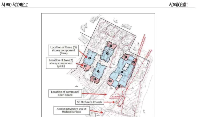
The Land, along with adjoining land, has the benefit of a Concept and Stage 1 Development Consent (DA 6/2012/JP) for a mixed density residential development of a total of 195 dwellings comprising 78
The Developer has also lodged four Development Applications 1683/2019/HA, 826/2019/HA,
The Land therefore already has an existing concept approval for 118 dwellings, and recent
Operative provisions 1. Defined meanings
- No restriction on Council’s Powers
- Operation of this Agreement
- Dedication
- Monetary Contributions 1 Payment
- Works
- Ownership of Works
- Application of s7.11 and s7.12 of the Act
- Dispute resolution 1 Disputes
- Registration of document on Title 1 Acknowledgement
- Definitions and interpretation 1 Definitions
This document is made in respect of the Proposed Development and applies to the Land. Handover means the handover to the Works Council in accordance with this Agreement.
Location Plan
Proposed Development
Dedication Land
The Works
Monetary Contributions
Additional Monetary Contribution
Timing of payment of Monetary Contribution and Additional Monetary Contribution
Execution Page
The nature of the planning agreement is a contractual relationship between the council and the developer to undertake the contributions. The planning agreement furthers the Council's charter under section 8 of the Local Government Act 1993 as follows:.
NORWEST NSW 2153
Acting Director Central (Western) at the Department of Planning, Industry and Environment, as delegate of the Minister for Planning and Public Spaces, have
- Delete
- Director, Central (Western) at the Department of Planning, Industry and Environment, as delegate of the Minister for Planning and Public Spaces, have
I refer to the Department of Planning, Industry and Environment (Department) letter dated April 2021, confirming the finalization dates and milestones for the planning proposals to be finalized this year, including the subject planning proposal in relation to 64 Mackillop Drive , Norwest and 34 Salamander Grove, Baulkham Hills. I have decided as the Minister's delegate, in accordance with section 3.34(7) of the Environmental Planning and Assessment Act 1979, to amend the Gateway determination of 11 February 2018 for PP_2018_THILL_009_00 (as amended).
The Council is obliged to exhibit and report on the proposal in accordance with the specified milestone dates as follows:.
INDEX
DEVELOPMENT CONTROL MAP SHEETS
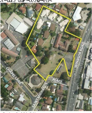
A map showing which Residential DCP Sheets apply is provided in Appendix B – Residential DCP Sheet Guide of this Section of the DCP. This DCP section contains site specific objectives and controls for land adjacent to Heritage Park, Gilroy College Target Site, Hunterford Estate in Oatlands, a residential area located on the corner of Old Windsor Road and Seven Hills Road, Baulkham Hills and land at 64 Mackillop Drive, Baulkham Hills (Refer to Appendix C – Neighborhood Plan Maps and Site Specific Controls herein.
AIMS AND OBJECTIVES OF THIS SECTION
OBJECTIVES AND
DEVELOPMENT CONTROLS
LAND TO WHICH THIS SECTION OF THE PLAN APPLIES
INTRODUCTION
- RESTRICTED DEVELOPMENT AREAS
- SITE ANALYSIS 2.2. SITE SPECIFIC DEVELOPMENT
In addition to this part of the DCP, the Council has adopted a number of site-specific development controls to address issues specific to certain areas. In the event of any inconsistency between this section of the DCP and Site-Specific DCP sections, the Site-Specific DCP section alone shall prevail to the extent of the inconsistency.
CONTROLS
STREETSCAPE AND CHARACTER
Development subject to wildfire risk is required to meet the requirements in these guidelines. To ensure that the proposed development does not result in movement or slippage. ii) Ensure that ground movement or landslides do not adversely affect the proposed development. a) Areas potentially subject to movement or slip have been identified by The Hills LEP 2012 Landslide Risk Maps or identified by the Board as subject to movement or slip.
To ensure that new development respects and enhances the green and garden character of The Hills Shire. vi). Reference should be made to the requirements of the Environmental Planning and Assessment Act 1979, and the Endangered Species Conservation Act 1995. i) Minimize land degradation, water pollution and damage to infrastructure through accumulated sediment in accordance with Council's ESD objective 3 ii) To ensure that development controls are identified for all stages of development and to ensure a consistent approach to erosion and sediment control. a).
EROSION AND SEDIMENT CONTROL
BUSHLAND AND BIODIVERSITY
Stimulating the reuse of rainwater. a) Water Sensitive Urban Design (WSUD) measures should be applied in the management of the site/development storm water in terms of water retention, reuse and cleaning. All developments should consider using one of the following water sensitive urban planning measures:-.
STORMWATER MANAGEMENT
The sign's size, shape, materials and location must complement the visual character of the surrounding area. I). A detailed description of the actions required to implement each of these measures is included in Appendix B – Water Sensitive Urban Design of the Hills Shire Development Control Plan.
SIGNAGE 2.10. HERITAGE
- R ESIDENTIAL L OT W IDTH AND D EPTH
In these circumstances, a letter of consent from the owner(s) of the downstream properties must be submitted with the Development Application. The controls relating to the erection of a dwelling must still be considered at the subdivision stage to ensure that all plots created can accommodate a suitable dwelling in accordance with this Section of the DCP.
SUBDIVISION
- P EDESTRIAN A CCESS , S AFETY AND
- B UILDING P LATFORM AND V IEWS
- B UILDING S ETBACKS
Except for land with destination E4 Environmentally friendly living, where the minimum facade width is 23 meters. c) The minimum depth of plots on which a home is permitted is 27 metres. This is necessary to ensure that vehicles parked in the driveway in front of the garage do not infringe the road reservation. f) The maximum width of a house must be:.
DWELLINGS
- W ASTE C OLLECTION
- D EVELOPER C ONTRIBUTIONS
- P RIVATE O PEN S PACE
- B UILDING H EIGHT
- S ITE C OVERAGE
- D WELLING D ESIGN AND C ONSTRUCTION
- L ANDSCAPING AND O PEN S PACE
- C UT AND F ILL
- P RIVACY – V ISUAL AND A COUSTIC
- B UILDING M ATERIALS
- S OLAR A CCESS
- A CCESS AND S URVEILLANCE
- O N -S ITE S EWAGE M ANAGEMENT
- L IGHTING
- C AR P ARKING AND V EHICULAR A CCESS
- V ENTILATION
- S TORAGE AND F ACILITIES
For the purposes of this plan, the calculation of the coverage of the site is subject to the following criteria:. ¾ The total land area of the plot is used in the calculation of the coverage of the terrain.
WASTE MANAGEMENT 2.15. FENCING
Part B Section 2 Residential requirements, safety and security compliance. a) The planning of the site and the design of the apartment must allow a general observation of the road, the location and the approaches to the entrance of the apartment from inside each apartment. To encourage building designs and construction techniques that will minimize waste generation in line with the Council's ESD Objective 6. iv) Minimize the generation of waste to landfill through the waste hierarchy in line with the Council's ESD objective 6. v) Assist in achieving federal and state government waste minimization objectives.
D EMOLITION
¾ must allow bins to be wheeled to the curb on flat or sloping surfaces with a maximum grade of 7% and not over steps, landscape edges or gutters or through the dwelling. i). To promote improved project management and reduce the demand for waste disposal during demolition and construction in line with Council's ESD Objective 6. ii) To maximize, reuse and recycle building/construction materials in line with the Council's ESD Objective 6. iii).
C ONSTRUCTION
- SUBDIVISION APPLICATIONS / SMALL LOT HOUSING UNDER CLAUSE 4.1B
- DWELLINGS AND ADDITIONS / ALTERATIONS TO AN EXISTING
- INFORMATION REQUIRED FOR A DEVELOPMENT APPLICATION
- SWIMMING POOLS
- REFERENCES
Please refer to Part A – Introduction, Section 4.0 for general filing requirements and detailed requirements to be included in each of the above documentation. Depending on the nature of the site and application, the following reports may be required.
APPENDIX A - DEVELOPMENT CONTROLS CALCULATION SHEET
APPENDIX B - RESIDENTIAL DCP MAP SHEET GUIDE
APPENDIX C - PRECINCT PLAN MAPS AND SITE SPECIFIC CONTROLS
LAND TO WHICH THIS SECTION OF THE PLAN APPLIES
CORNER OLD WINDSOR ROAD AND SEVEN HILLS ROAD, BAULKHAM HILLS
- FENCING C.1.3 BUILDING SETBACKS
- BUILDING PLATFORM AND VIEWS C.1.4 CAR PARKING AND VEHICULAR ACCESS
- LAND TO WHICH THIS SECTION OF THE PLAN APPLIES
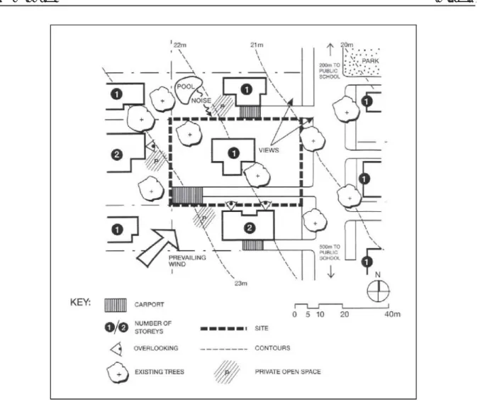
The Hills Shire Council Page 34. i) Properties should be designed and/or sited to maximize views. ii) Views of the estate from public places such as the proposed highway, open space and surrounding roads should be considered during the design phase. a) Homes are designed to maximize existing views to the east and south. i) Creating an attractive, interesting and pleasant streetscape through the siting of buildings and landscaping. ii). To allow the free flow of traffic in the streets of the estate. a) Two parking spaces must be provided on site for each dwelling.
HUNTERFORD ESTATE, OATLANDS
- LANDSCAPING AND OPEN SPACE C.2.4 BUILDING SETBACKS
- For all dwellings (except residential flat buildings) with a site density of 40
- For all dwellings (except residential flat buildings) with a site density more than 40
- PRIVACY
- DWELLING DESIGN AND CONSTRUCTION
The site layout should take into account the views available from the south-east corner of the site. The minimum area of private open space required is 20% of the site area, with a minimum dimension of 3 meters.
AREAS
LAND TO WHICH THIS SECTION OF THE PLAN APPLIES
To promote the monitoring of RDA and open areas, the only fence is allowed along. To maintain residents' views of open spaces and limited development areas. ii) To ensure that the development of the land in question has minimal impact on the views of residents and visitors to the locality. a) Landscape and building design and placement should take into account the topography to ensure the impact on views from:.
LAND ADJOINING HERITAGE PARK
- DWELLING DESIGN AND CONSTRUCTION
- BUILDING SETBACKS C.3.4 SITE COVERAGE
- FENCING C.3.7 CAR PARKING AND VEHICULAR
It must be ensured that the planning of roads and the placement and orientation of buildings allow adequate control of restricted development areas and public or shared open spaces. ii) Building design to encourage direct views of restricted development areas and open space areas from primary living spaces and private open spaces. a) Driveways or private access roads are located along the boundaries of open space or restricted development areas to provide natural control and ease of access. The following building restrictions apply to small lots (See Clause 4.1B of The Hills LEP) within the area known as Land adjoining Heritage Park. i) Create an attractive, interesting and pleasant street by placing buildings and landscaping. ii).
ACCESS
LAND TO WHICH THIS SECTION OF THE PLAN APPLIES
GILROY COLLEGE TARGET SITE
- STREETSCAPE AND CHARACTER
- BUILDING SETBACKS
- LANDSCAPE AND OPEN SPACE
- DWELLING DESIGN AND CONSTRUCTION
- SOLAR ACCESS C.4.6 PRIVACY – VISUAL AND
Provide open space for recreation and use by future residents of new buildings. ii). To fully integrate landscape design as part of the overall development of the city. iv).
ACOUSTIC
SITE ANALYSIS
LAND TO WHICH THIS SECTION OF THE PLAN APPLIES
BAULKHAM HILLS
- H ERITAGE
- S ITE P LANNING
- SITE SPECIFIC OBJECTIVES AND DEVELOPMENT CONTROLS
- S URFACE W ATER R UNOFF
- S INGLE D ETACHED D WELLINGS
- R OADS
- R ESIDENTIAL F LAT B UILDINGS
- M ULTI D WELLING H OUSING
- H OUSING AS PER C LAUSE 4.1 B OF T HE
- FENCING
- S TREETSCAPE AND C HARACTER
- R ESTRICTIONS ON OCCUPATION OF SENIORS HOUSING
- SITE SPECIFIC OBJECTIVES AND DEVELOPMENT CONTROLS
- LAND TO WHICH THIS SECTION OF THE PLAN APPLIES
- SITE SPECIFIC OBJECTIVES AND DEVELOPMENT CONTROLS
- LAND TO WHICH THIS SECTION OF THE PLAN APPLIES
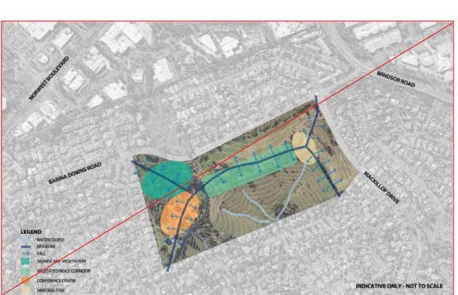
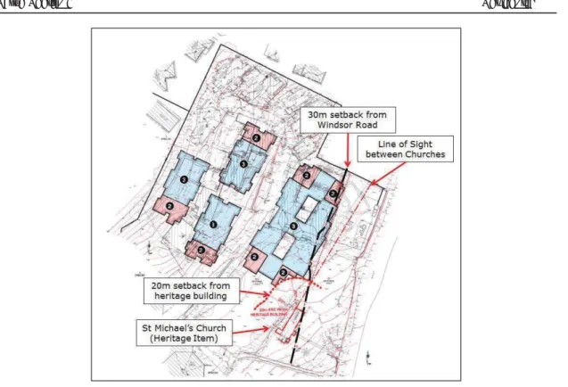
Key features of the site are shown in Figure 3. Hills Shire Council Page 50. A minimum rear setback of 10 meters shall be provided on the southern boundary of the building site.
PAGE 197
- D ENSITY
- O PEN S PACE
- P RIVACY
- V EGETATION
- S ITE P LANNING
- SITE SPECIFIC OBJECTIVES AND DEVELOPMENT CONTROLS
- LAND TO WHICH THIS SECTION OF THE PLAN APPLIES
No future development on the site shall have an entrance or exit from Windsor Road. The objectives and control of the development of this site are set out in the following sections. i) Protect, contribute to and enhance the existing residential character and amenity. ii).
8. 370 OLD NORTHERN ROAD, CASTLE HILL
This section of the development control plan sets site specific objectives and controls to guide future development on Lot 2 DP 135804, No 370 Old Northern Road, Castle Hill (see Figure 6). In the event of any inconsistency between this Section of the DCP and any other sections of the DCPs, the provisions of this Section shall prevail only to the extent of the inconsistency.
PAGE 199
- T RANSPORT
- A CCESS
- G EOTECHNICAL S ITE S TABILITY
- H ERITAGE
To reduce potential conflicts with bus operations. a) Future development at the site will address any ongoing or temporary impacts to Transit Stops in the vicinity of the site. i). The median handling and deceleration lane shall be constructed at the cost of the applicant.
PAGE 201
Land to which this Section applies
Purpose of this Section
Relationship to other Sections of the DCP
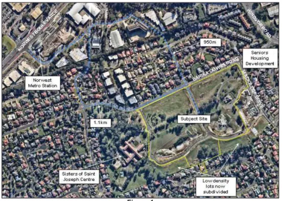
The site has a total area of 8.7 hectares and is located on the outskirts of Norwest Business Park and Norwest Metro Station Precinct. To the west of the site is the Conference/Treatment Center of the Sisters of Saint Joseph, associated facilities and the former priest's home.
4Figure 2: Urban Context