The waterways direction reflects the Council's desired approach to guiding the planning, protection, management and maintenance of the Shire's waterways. It facilitates a comprehensive Council approach to achieving high quality, ecologically sustainable and accessible water and coastal corridors that meet community and environmental needs. The Baulkham Hills Shire Local Government Area straddles the Hawkesbury River and Upper Parramatta River catchments.
The size and unique diversity of the Shire's waterways present many challenges to the management of the environment and leisure spaces. The Council's primary challenge is to balance the needs of society and the environment on a daily basis while dealing with development pressures created by Sydney's increasing needs. The scope and size of the Shire's waterways and the range of ecosystems covered by them.
The need to meet the needs of the current and future population in an economical and timely manner. It facilitates a whole-of-Council approach to achieving high-quality, ecologically sustainable and accessible waterways and riparian corridors that meet the needs of the community and the environment. To provide direction for the long-term planning, protection and management of the Shire's waterways in order to meet the existing and future needs of the population.
One of the main objectives of the Waterways Directorate is to respond to and implement State Government legislation, policy and objectives outlined in its plans and strategies.
Context
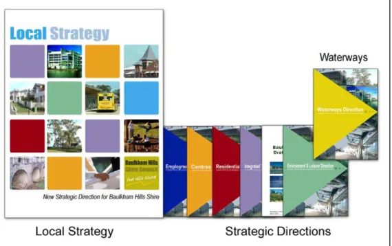
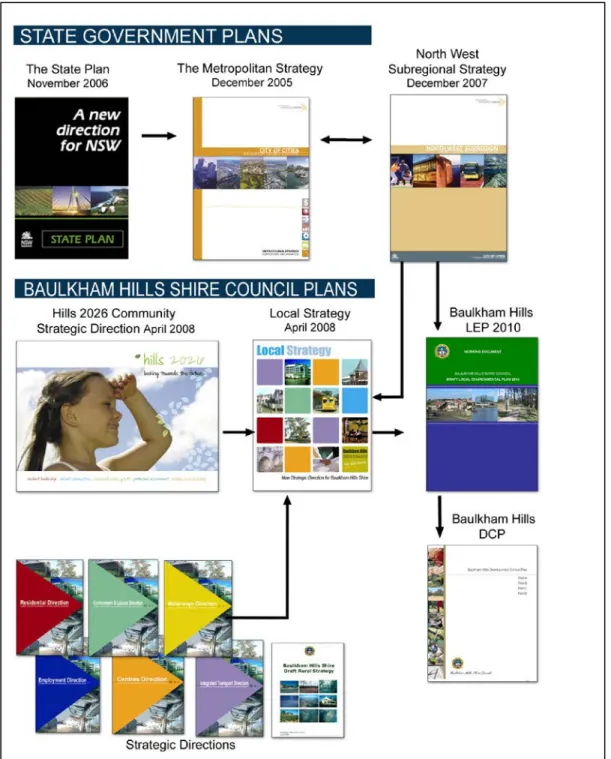
Looking Towards the Future identifies the Shire's direction for the future and demonstrates how the Council will adapt its delivery of services and facilities to support the direction. Hill's 2026 Community Strategic Direction also brings together all current council planning processes under one clear direction, with the Waterways Direction supporting the achievement of identified directions and actions. The Local Strategy is the most important document to communicate the future planning and growth of the Shire.
It details long-term planning for the Shire, ultimately involving all sections of the Council, to guide future decision-making. The Local Strategy is the main document expressing the Council's response to the strategies and actions identified in the NSW Government's planning strategies, including those identified as the specific responsibility of local government. The local strategy will also be the key document to implement the key themes and outcomes of the 'Hills 2026 Looking Towards the Future' within the context of land use planning in the Shire.
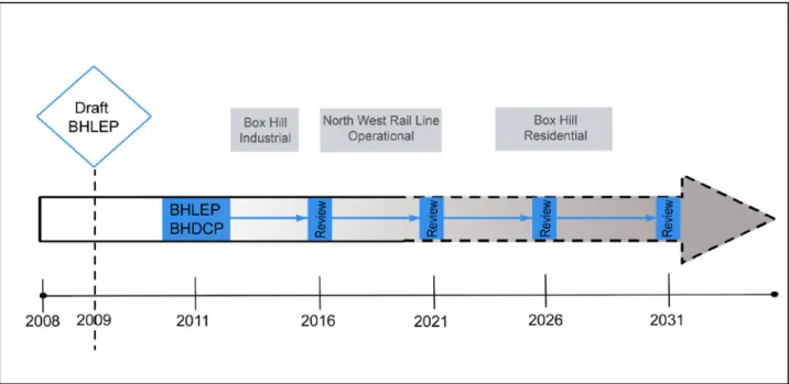
The local strategy will include a summary of the main directions, strategies and actions contained in the waterway direction. The Council is required to prepare a new LEP in accordance with the State Government's Standard Instrument (Local Environmental Plans) Order 2006, no later than March 2011. The current Baulkham Hills Local Environmental Plan 2005 includes a special use 5(c) (Trunk Drainage and Conservation) Zone.
This area defines local trunk drainage and riparian land in the Kellyville / Rouse Hill Relaxation Area, Balmoral Road Relaxation Area and Norwest. In other parts of the Shire there is a local drainage system within the land which is dedicated to open space. The standard instrument specifies the following land use and land use area objectives that may be suitable for use in waterway zoning.
In order to inform the drafting of the LEP, the Waterway Direction will highlight matters for consideration in determining which zones, objectives and types of land uses may be appropriate in various locations. The stormwater management section of the Baulkham Hills Development Control Plan currently requires that Water Sensitive Urban Design (WSUD) measures be implemented. In order to inform the review of the sections of the DCP that contain controls on stormwater management, the Waterways Direction.
Key Directions
The Council's Waterways Group is producing a document entitled 'BHSC WaterGuide', a technical guidance document which corresponds to and supports key waterways guidance. The BHSC WaterGuide uses a targeted, results-based approach to provide a basis for water planning and management in the Shire of Baulkham Hills. The BHSC WaterGuide will provide guidance in the preparation of Council's LEP and DCP in relation to current best practice in stormwater, floodplain and watercourse management, as well as providing guidance in the implementation of the Council's work program and own activities.
The Council's Waterways Group is currently progressing the development of a Stormwater Infrastructure Management Plan and a Natural Waterway Asset Management Plan. The Water Resources Management Plan will provide guidance for the further development of the waterways capital works program and the design of stormwater systems for current and future generations. The Waterways Capital Works Program contains a list of measures to manage the natural and constructed waterway systems throughout the Shire.
The program supports Key Directions in the Waterways Direction and facilitates the necessary planning to achieve goals and objectives consistent with those of the state government's current plans, policies and strategies. Objective: To be a market leader in water management and planning, by creating a catalyst for change and thinking beyond current 'Best Practice'. a) Develop the Waterways Directive and have it approved and adopted by the Council. It is estimated that 45% of the constructed stormwater system in the Shire has been mapped, representing some 230 miles of stormwater pipelines.
The Waterways Directive supports the implementation of the mechanisms, but the Council is investigating whether the required number of proposed measures is adequate to achieve the desired result. The ability of the responsible Council team(s) to meet these requirements and resources is ensured before progressing to the detailed design and construction development stage. Waterways Direction and BHSC WaterGuide. a) Incorporation of the principles and objectives of the waterways guideline and the BHSC WaterGuide into the Council's DCP.
The northern rural areas of the Shire drain to the Hawkesbury River, while the southern urban areas of the Shire ultimately drain to the Parramatta River. But Council's Waterways Team is currently developing a Natural Waterways Asset Management Plan that will have the location and condition of all natural waterways in the Shire mapped and fed into Council's GIS. In addition to the development of a Natural Waterways Asset Management Plan, the management of the Shire's natural waterways will be guided by the Waterways Direction, the 'BHSC WaterGuide' and the continued development of the Waterways Capital Works Programme.
Use the results to prioritize the waterway works program and review the prioritized plan annually. and works to improve the quality, quantity and ecology of the water corridor. a) Address increased flows, pollutant control and capture, weed control and removal, and waterway corridor improvement through the program of works. Objective: To improve the health of waterways through the effective implementation of Water Management, the BHSC Water Guide and the program of works.
Monitoring & Review
Glossary
A plan setting out methods and priorities for maintaining, improving, upgrading and rehabilitating all natural waterways in the Shire, taking into account factors such as location, condition and performance. North West Subregion The North West Subregion comprises the local government areas of Baulkham Hills, Blacktown, Blue Mountains, Hawkesbury and Penrith.iv North West Subregional. North West Subregion: The Subregional Strategy has been prepared by the Department of Planning to translate the Metropolitan Strategy into a specialized strategy for each local government group in Sydney.
Riparian areas considered to be of regional importance due to their high ecological value in water and on land. Riparian land Area of land adjacent to a waterway that affects or is affected by the waterway. Section 117 Directions Section 117 of the 1979 Spatial Planning and Assessment Act empowers the Minister of Planning to include specific directions in local environmental plans.iv.
A plan that sets out methods and priorities for maintaining, improving and upgrading all stormwater assets in the Shire, taking into account factors such as location, condition and performance. It will provide guidance for the development of the Waterways Capital Works program and water system planning. Waterway direction One of the strategic directions that form the basis for the central guidelines in the Local Strategy.