INTRODUCTION
BACKGROUND
DESCRIPTION OF THE PROJECT
M ETHODOLOGY
- Preliminary Desktop Study
- Site Investigation
An assessment of the project area and its potential constraints was made by reviewing a number of databases maintained by government agencies. The locations of wetlands and ESAs within the project area were determined using the Department of Environment and Conservation's (DEC) Environmentally Sensitive Areas (ESA) mapping tool. http://portal.environment.wa.gov.au/portal/page?_pageid amp;_dad=portal&_sc hema=PORTAL), see Appendix B, and if seeking advice from a DoW Regional Officer, see Appendix F. Search Department of of Indigenous Affairs (DIA). http://www.dia.wa.gov.au/Heritage/SitesSurveysSearch.aspx) database to determine if the project area contains any Aboriginal heritage sites, see Appendix E.
The Water Information Officer of the regional office of the Department of Water (DoW) consulted on sensitive water resources (including public drinking water source areas) to determine whether the project site supported, or was adjacent to, any lakes, river or significant wetlands or designated areas, refer to Appendix F. There are no known previous land use activities in or near the project area that have the potential to create pollution, e.g. gas station. The Western Australian Planning Commission Acid Sulphate Soil Maps were reviewed and a self-assessment was carried out (http://www.wapc.wa.gov.au/Publications/213.aspx) to determine what level of risk the area is exposed to. of the project, refer to Appendix G.
The Department of Agriculture and Food has been consulted to determine whether there are known populations of notified plants or weeds of concern in or adjacent to the project area, see Appendix H. Decision to refer the project to the Commonwealth Department of Environment and Food (DEW) Resources are based on whether the project will affect matters of national importance, e.g. World Heritage properties, protected wetlands and migratory species, Commonwealth marine areas, threatened species or communities or nuclear measures (see the Commonwealth website. www .deh.gov.au/epbc/assessmentsapprovals/index.html for further information and a tool page for search at http://www.deh.gov.au/erin/ert/epbc/imap/map.html), see Appendix JAZ.
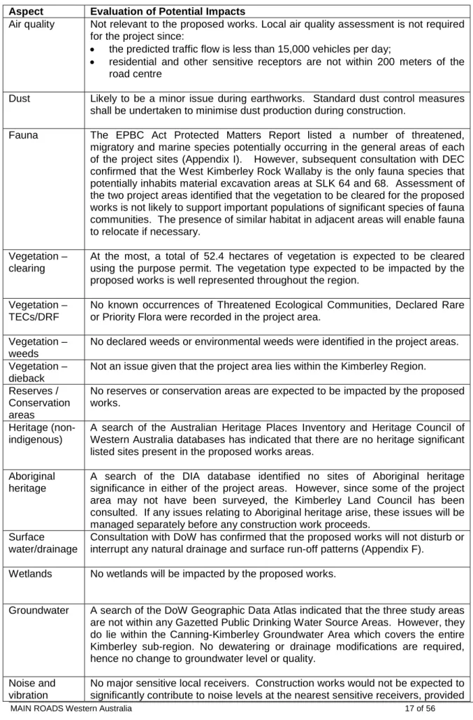
EXISTING ENVIRONMENT
Attrition is not an issue in the area where proposed works are expected to be carried out. A site visit was conducted by Project Manager Wayne Blisner and Environmental Officer Marni Baetge on 6/8/07 to examine the general characteristics of the area. Other issues considered included topography, the impacts on creek lines, property access and the potential for noise and vibration impacts (decay).
No declared weeds or serious environmental weeds were detected in any of the project areas.
CLEARING OF NATIVE VEGETATION
ASSESSMENT OF APPLICATION AGAINST CLEAR PRINCIPLES. a) Native vegetation should not be cleared if it contains a high level of biological diversity. Diversity will not be compromised and therefore the proposal is not contrary to this Principle. The proposal does not conflict with this principle as no threatened ecological communities (TECs) have been identified within the project area. e) Native vegetation must not be cleared if it is significant as a remnant of native vegetation in an area that has been extensively cleared.
DEC's web-based Geographic Data Atlas mapping tool. g) Native vegetation should not be cleared if the clearing of the vegetation is likely to cause significant land degradation. Native vegetation should not be cleared if the clearing of the vegetation is likely to have an impact on the environmental values of any adjacent or nearby conservation area. The proposal does not conflict with this Principle as residual native vegetation in the project area is not associated with any adjacent or nearby conservation areas.
DEC's web-based Geographic Data Atlas mapping tool. i) Native vegetation must not be cleared if the clearing of the vegetation is likely to cause deterioration in the quality of surface or underground water. DEC's web-based Geographic Data Atlas mapping tool. j) Native vegetation must not be cleared if the clearing of the vegetation is likely to cause or exacerbate the occurrence or intensity of flooding.
ASSESSMENT OF ASPECTS AND IMPACTS
The requirements of the Shire of Broome must be met in respect of noise management and construction working hours. Visual amenity The proposed works will result in minor and short-term visual impacts during construction. Appropriate site completion treatments, including landscape planting and rehabilitation, can result in an improvement in local visual amenity.
Provided that traffic management and signage to main road standards are used, none of the proposed works pose any significant risk to public safety. The proposed works will serve to increase public safety by improving road conditions during flood events. Contamination There are no known previous land use activities in or near the project area that could create contamination, e.g. gas station.
WAPC's self-assessment (Planning Bulletin 64) indicates that no further land investigation is required for the project. As the proposed works are entirely within the existing road reserve, no further changes to the Local Government Planning Scheme or District Scheme will be required.
DECISION TO REFER
ENVIRONMENTAL MANAGEMENT PLAN
This vegetation must be used during all rehabilitation works and either felled or replaced in accordance with the EMP. Maintain the hydrological regime that exists before the construction of the proposal and prevent erosion in areas prone to flooding. Areas subject to erosion as a result of clearing shall be stabilized and designed to minimize rainfall/runoff impacts.
If washing facilities or chemical storage occur on site, best management practices will be used in accordance with DEC's Water Quality Protection Notes, Mechanical Equipment. Construction Ensure that the construction of the proposal does not become a public nuisance. Works associated with the construction of the development must not impede public access along the adjacent reserve.
Where trucks leaving the site are found to be carrying excess material on sealed surfaces, these areas will be swept to reduce dust. Construction Ensure that the construction of the proposal is managed to a standard that minimizes any adverse impacts on the environment. All waste oil will be collected for recycling and any empty fuel/oil containers, used filters and waste hydraulic parts will be collected and stored in an allocated area and then removed to an approved site.
The project areas, including hard surfaces, will be kept tidy at all times. All waste on the project will be placed in lidded containers and disposed of at an approved landfill. There will be a water tanker on site at all times. No fires may be lit within the project area.
If any materials of Aboriginal significance are discovered, work will immediately stop within 100m of the material and the site will be inspected by a qualified archaeologist. All construction waste materials must be completely removed from the site after construction is completed. Final cleaning must be to the satisfaction of the Project Manager and Site Supervisor.
This record is located in pit areas that are close to each other. Main Roads The Kimberley Region is proposing to improve the formation and drainage of a section of the Derby - River Gibb Road from SLK 62.3 (end of seal) to SLK 110.22 (Kimberley Diamond Mine Access). There will be no clearing of remaining native vegetation for road improvement works and all road rehabilitation works will be carried out within the maintenance area.
However, three areas outside the road reserve will be concerned to remove gravel and borrow material for road improvement works. Approximately 40,000 cubic meters of natural road construction materials are needed to complete the planned works. Attached is a one-word document with an extensive map of the proposed roadworks location, two aerial maps of the three areas where we propose to extract road construction materials, and a coordinate table of the borrow pit areas.
Could you please identify if any endangered fauna exists within each of the three borrow pit areas and if so please name each species. Thank you for the plant images from your environmental survey for Gibb River Road Reconstruction Project. No declared plants or serious environmental weeds appear to be present at the 3 material investigation areas.
This email and files sent with it are privileged and confidential information. intended for use by the addressee. The confidentiality and/or privilege of this email is not waived, lost or destroyed if it has been transmitted to you in error. If you have received this email in error, you should. a) not distribute, copy or take any action in reliance on it;.
DEPARTMENT OF ENVIRONMENT AND WATER RESOURCES
Further information is available in the detail part of the report, which can be accessed by scrolling or following the links below. If you propose to undertake an activity that may have a significant impact on one or more matters of national environmental importance, you should consider the Administrative Guidelines on Significance - see. This part of the report provides information that may also be relevant to the area you have nominated.
This part of the report summarizes the conditions of national environmental significance that may occur in or may relate to the area you have designated.