The rural lands of the Hills Shire have long been an integral part of its identity as the "Garden Shire". The Countryside Strategy 2019 provides an overarching strategic framework for the management and protection of the Shire's rural land. The 2019 Rural Strategy focuses on the 70 per cent of The Hills Shire that is in the Metropolitan Rural Area - land that is the green backdrop to the urban area of north-west Sydney.
The Rural Strategy 2019 sets the basis for strategic planning of rural land in the Shire up to 2036.
Vision – Hills Future 2036
It informs the planning priorities and five-year actions contained in Hills Future 2036, our Local Strategic Planning Statement. To form exceptional places to live, work and relax where expected growth brings vitality, diversity, livability and prosperity to the Hills. We have a legislative obligation to implement the goals and vision of NSW Government's strategic directions and other policies, as well as an obligation to The Hills community to create a place where people want to live, work and play.
STRATEGIC CONTEXT
It is supported by background strategies, including this one, which are being executed in key areas to provide the vision for the future of The Hills Shire. We have reviewed the national and local strategic planning framework and recognize that The Hills Shire will be an integral part of Greater Sydney, providing places for people, accessible and walkable neighborhoods and a diverse range of new housing. The Greater Sydney Region Plan recognizes the importance of the Metropolitan Rural Area as a location where agricultural production, processing and sale contribute to prosperity.
Representing 70 per cent of the Hills Shire, this land is rich in biodiversity, scenic and productive features.

THE HILLS SHIRE’S RURAL LANDS
THE HILLS SHIRE’S RURAL LANDS
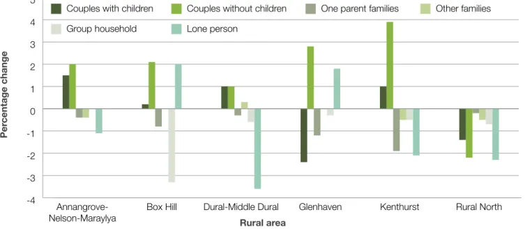
In 2016, the rural areas of The Hills were home to approximately 15,500 people, making up approximately 10 percent of the population, residents of The Hills. By 2036, the rural population is forecast to be around 17,400 and will account for around six per cent of the Shire's total population. People living in rural areas on average earn lower incomes than the Shire average, with a greater proportion of the rural population earning a weekly wage between $0 and $999 per week.
Although these elements combine to limit development, they are essential to the Shire's identity and function within Greater Sydney. Much of the rural area is landlocked in some form, with limited amounts of productive land available. Problems also arise due to the incompatibility between the scale and density of these developments and the prevailing open and undeveloped character of the rural area.
Extractive industries are located in Maroota in the north of the Shire and produce sand and materials for the construction and landscaping industries. This accounted for approximately 1.5 per cent of the total economic output of The Hills Shire. Similarly, The Hills contributed around 40 per cent of Greater Sydney's peach and nectarine output in 2015–16.
Jobs in the mining industry in the rural north of the Shire are concentrated in the RU1 Primary Production Zone along Wisemans Ferry Road. Tourism and services that support rural industries are significant contributors to the functioning of the rural area and the success of the rural economy. Major components of the Shire's tourism industry are located in or based around the Shire's rural area.
Equally important to the growth of the rural economy is the ability of services that support rural industries to be located near productive areas.

PLANNING PRIORITIES
PLANNING PRIORITIES
Our previous Rural Lands Strategy outlined a growth management philosophy to balance growth with the protection of rural land. With the exception of NSW Government-led planning for growth zone areas and a small number of other developments, we have generally confined urban development to the existing urban area of the Shire. Given the significant amount of existing residential zone land available, there is no need to convert rural or environmental zone land to residential uses.
The Greater Sydney Region Plan states that urban development should be confined to the urban area (Strategy 29.2), and that "rural-residential development is not an economic value of the metropolitan rural area". To support this, we introduce an urban growth boundary, largely based on the formal boundary between the metropolitan urban and metropolitan rural areas. The border will protect rural areas for productive use and scenic values, avoiding levels of development more suited to urban areas.
Future reviews of the Greater Sydney Region Plan may identify the need for additional urban areas as part of a structured and carefully planned approach to managing the long-term growth of Sydney. If this happens we will work with the NSW Government to select appropriate areas for consideration.
Rouse Hill
By making planning controls for secondary and senior housing clearer and more understandable for land on the urban and rural fringes, pressure on rural areas is reduced and an appropriate level of development is achieved. In circumstances where the probability of negative impacts is low, a second residence with a floor area of more than 60 square meters can be supported, regardless of the size of the main residence. We work with the Greater Sydney Commission and other stakeholders on senior housing projects under the State Environmental Planning Policy (Senior and Disabled Housing) 2004.
Implement an urban growth boundary that largely follows the boundary of the RU6 transition zone. Implement the outcomes of the Greater Sydney Commission working group on housing for the elderly in rural areas. Community involvement gives legitimacy and weight to any policy outcome and inevitably serves to increase community confidence in the planning system.
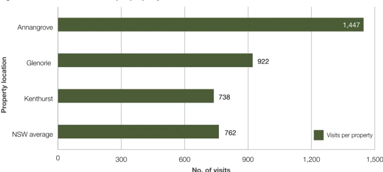
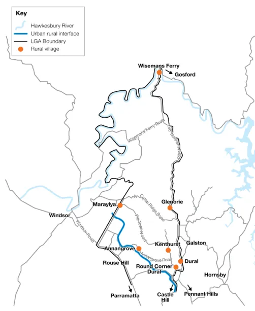
Place-based planning requires that any application for the extension of rural villages fits within criteria developed in consultation with potentially affected communities. Given the importance of maintaining the rural character of The Hills, character overlays can be useful for planning for rural village renewal. We will consult with the community to formulate a local character statement for the RU6 transition area, particularly in Annangrove, Glenorie and Kenthurst.
We are requesting additional zoning objectives and a review of permitted uses to further recognize the rural and scenic character of the RU6 transition zone and the need for land uses and development intensities compatible with that character. The characteristics of this area are significant enough to warrant specific objectives which encourage land use compatible with the scenic landscape and the predominant rural residential character.
Criteria New proposals must demonstrate
A greater degree of housing diversity may attract a wider variety of potential residents and may provide housing options for young people or families who wish to stay in the area but cannot afford a larger home, or downsizers looking for a more manageable property in the same area. Young professionals and families are increasingly moving away from the Shire's rural areas; there are a number of reasons for this, however high average house prices and limited choices are contributing factors. The consultation process to develop a character statement for the RU6 Transition Area will also clarify the priorities that communities in and around rural villages have for the regeneration and limited growth of these places.
These priorities will inform the site-based development criteria that any proposal to expand these villages must meet. Any proposal to change planning controls in these areas would need to include a holistic plan for the whole area, not just a few smaller restricted areas.

Glenorie village
Annangrove village
Kenthurst village
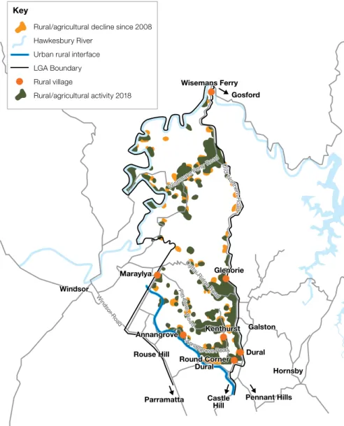
Certainty about the protection of these lands will stimulate growth in the agriculture and extractive industry sectors, providing more certainty about the future use of the land. Horticulture in The Hills is evolving towards more intensive modes of production, such as greenhouse hydroponics, as there is a limited supply of productive farmland within the Shire. To help with this evolution, we will be reviewing site coverage and working hours controls for farmland in the Hills Development Control Plan (DCP).
Given this shift in focus, intensive horticultural activity in the Shire could benefit from linking up with Western Sydney University's Greenhouse Research Training Institute at the Hawkesbury Campus. Our Economic Growth Plan, outlined in the 2019 Productivity and Centers Strategy, will target key rural industries and articulate how greater regional connectivity can help existing businesses grow and develop and attract new businesses to the Shire. The size of the Shire and the relatively small number of road and public transport links within the rural area present supply chain challenges for producers in the agricultural and mining industries.
In addition, certainty around the Outer Sydney Orbital alignment will assist in the Shire's rural productive industries adjacent to the planned future agricultural and agribusiness precinct within the Western Sydney Aerotropolis (Figure 31). Rural residential development contributes to housing diversity in the Shire, although environmental, social and financial costs are often higher in rural areas compared to urban residential areas and must be managed to avoid conflict with productive rural and environmental uses. The ability to locate these markets close to where the goods are produced ensures efficiency in the supply chain.
In order to provide appropriate support services for rural industry, we will review the admissibility of rural supply and rural industrial use in zones RU1 and RU6. In addition, we will work with stakeholders to explore the feasibility and potential locations for a future rural service hub in the north of the Shire.

IMPLEMENTATION, MONITORING AND REVIEW
Ag Econ Plus Consulting: Greater Sydney Region Metropolitan Rural Area Values, February 2017. Draft North West Sub-Regional Strategy 2006 Greater Sydney Region Plan March 2018 Central City District Plan March 2018 Nearmap http:// maps.au.nearmap.com /.