PLEASE SCROLL DOWN FOR ARTICLE
On: 20 June 2011Access details: Access Details: [subscription number 907448957]
Publisher Taylor & Francis
Informa Ltd Registered in England and Wales Registered Number: 1072954 Registered office: Mortimer House, 37- 41 Mortimer Street, London W1T 3JH, UK
Journal of the Royal Society of New Zealand
Publication details, including instructions for authors and subscription information:
http://www.informaworld.com/smpp/title~content=t918982755
Fire and slice: palaeogeography for biogeography at New Zealand's North Island/South Island juncture
SA Trewicka; KJ Blanda
a Ecology Group, Institute of Natural Resources, Massey University, Palmerston North First published on: 17 June 2011
To cite this Article Trewick, SA and Bland, KJ(2011) 'Fire and slice: palaeogeography for biogeography at New Zealand's North Island/South Island juncture', Journal of the Royal Society of New Zealand,, First published on: 17 June 2011 (iFirst)
To link to this Article: DOI: 10.1080/03036758.2010.549493 URL: http://dx.doi.org/10.1080/03036758.2010.549493
Full terms and conditions of use: http://www.informaworld.com/terms-and-conditions-of-access.pdf This article may be used for research, teaching and private study purposes. Any substantial or systematic reproduction, re-distribution, re-selling, loan or sub-licensing, systematic supply or distribution in any form to anyone is expressly forbidden.
The publisher does not give any warranty express or implied or make any representation that the contents will be complete or accurate or up to date. The accuracy of any instructions, formulae and drug doses should be independently verified with primary sources. The publisher shall not be liable for any loss, actions, claims, proceedings, demand or costs or damages whatsoever or howsoever caused arising directly or indirectly in connection with or arising out of the use of this material.
Fire and slice: palaeogeography for biogeography at New Zealand’s North Island/
South Island juncture
SA Trewicka* and KJ Blandb
aEcology Group, Institute of Natural Resources, Massey University, Palmerston North;bNew ZealandGNS Science, Lower Hutt, New Zealand
(Received11 August 2010; final version received7 December 2010)
A prominent feature of New Zealand biogeography is that species endemicity and diversity is not evenly distributed but shows an alternating pattern of latitudinal variation. Endemicity is generally highest in South Island and northern North Island and low in southern North Island.
A prominent landscape feature that ispartly correlated with thisisCook Strait, which separates the two main islands of New Zealand and marks the southern boundary of a region that interests biogeographers and geologists alike. This region encompasses a zone of intense tectonic strain related to the transfer of plate convergence via subduction into oblique-slip and strike-slip faulting. We review geological information and provide new palaeogeographic reconstructions of the area that depict changes in the distribution of mountains, the extent to which southern North Island was under the ocean, and the history of marine straits over the last 4 million years.
This information is essential for the development of testable biogeographic hypotheses. We find that the Wellington region wasformerly connected to the relatively mountainousMarlborough area, and more distant than today from the northern island of the time. Significant topography in the Kaimanawa Range isprobably of Early Pliocene age. However, the Ruahine-Tararua rangesand Taranaki-Taupo volcanicshave formed since c. 1 Ma. The implicationsfor the biogeography of central New Zealand are considerable in terms of habitat availability for establishment of terrestrial species and opportunities for range shifting of both terrestrial and coastal organisms.
Keywords: Neogene; Pliocene; Pleistocene, Quaternary; palaeogeography; land; North Island;
South Island; axial ranges; seaways; biogeography
Introduction
Biogeography is the study of the distribution of living things(Wallace 1876). It hasan obvious spatial component, but also a temporal ele- ment, ascurrent distributionsare the product of past evolutionary process; range changes, speciation and extinction. Approaches used by biogeographers to describe and interpret dis- tribution include taxon inventory, distribution mapping, ecological inference and modelling, and latterly phylogenetic and phylogeographic analyses of molecular data. However, as the
primary objective isto understand how biotas (assemblages of plants and animals) have come to occupy space, it is necessary that biogeogra- phershave accurate information about the history and development of habitable space.
The New Zealand archipelago haslong drawn the attention of biogeographersowing to itscombination of relatively large size, supposed isolation, potential antiquity and distinctive biota (see Goldberg et al. 2008).
In particular, events associated with the tec- tonic breakup of Gondwana, which preceded
*Corresponding author. Email: [email protected] iFirst, 2011, 131
ISSN 0303-6758 print/ISSN 1175-8899 online
#2011 The Royal Society of New Zealand DOI: 10.1080/03036758.2010.549493 http://www.informaworld.com
Downloaded By: [Massey University Library] At: 22:04 20 June 2011
formation of New Zealand, have often been emphasized as central to understanding its biogeography (but see Campbell & Hutching 2007; Trewick et al. 2007; Landiset al. 2008).
However, tectonism is by no means restricted in importance to the early history of the New Zealand region, rather itsmajor influence with respect to the size, shape and topography of modern New Zealand began near the start of the Miocene (c. 23 Ma), and thusunderpinsthe geographic context of local evolution. Since that time, New Zealand’sform hascontinued to be modified, not least in the last 4 million years(Myr).
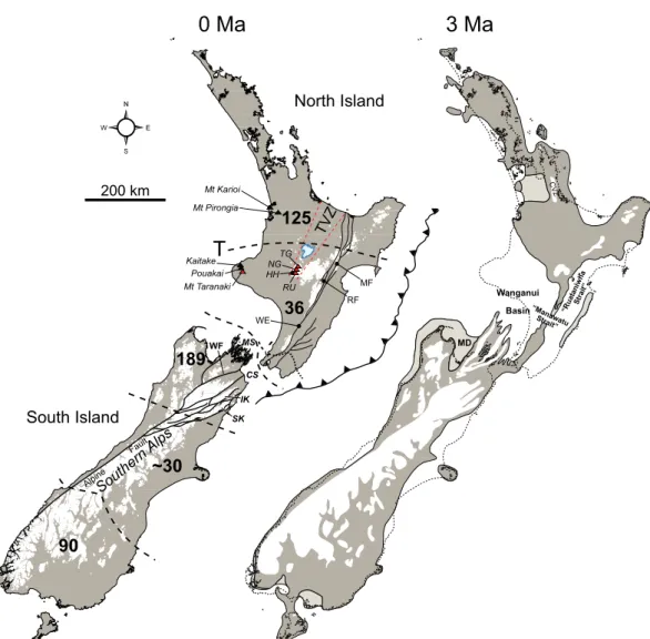
Today, New Zealand consists of two main islands, and one of its more readily apparent landscape features is Cook Strait, a seaway c.
25 km acrossat itsnarrowest point that separates these (Fig. 1). In addition to being a highly visible habitat discontinuity, Cook Strait marksthe southern boundary of a biogeo- graphic region of comparatively low plant endemicity that extendsnorth to Taupo. There are many instances of disjunct plant distri- butionsacrossthisregion that also imply some past or present biogeographic limitation (Wardle 1963, 1988, 1991; Burrows1965;
McGlone 1985; Craw 1989; Rogers1989;
Connor 2002; Gibbs 2006; see also McGlone et al. 2001; Wallis& Trewick 2009) (Fig. 1).
Equivalent patternsof diversity and endemicity are less obviously concordant among terrestrial animals, but some taxa do have range limits associated with the Cook Strait (e.g. separate Petroica robinseither side in the North and South islands, a mayflyAcanthophlebia cruena- ta and a skink Cyclodina aerea range from Cook Strait throughout North Island but not in South Island, the giant weta Deinacrida con- nectens throughout mountainsof South Island to Marlborough but not in North Island).
Furthermore, although a generalized boundary of plant species endemism occurs at Cook Strait, it isnotable that many plant taxa with predominantly South Island distributions have rangesthat extend acrossCook Strait to the southern tip of North Island (Wellington
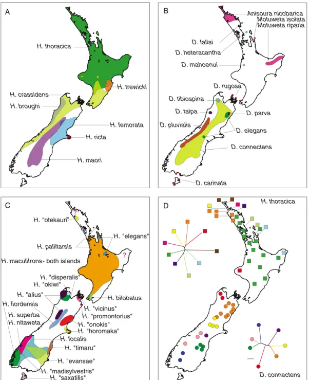
region) but no further (Rogers1989). Cook Strait, therefore, appearsto be coincident with past biogeographic process(es). At a larger, New Zealand-wide scale, spatial diversity with- in many speciose animal groups does reveal a trend. For example, among the comparatively well-studied flightless crickets known as weta (Anostostomatidae), both diversity and ende- micity are highest in South Island (Fig. 2).
There are also some endemics in northern North Island but much of North Island and in particular the central/southern portion, is occupied by few, widespread species, and a few species have ranges that span Cook Strait.
A recent review of New Zealand phylogeo- graphy (the study of the geographic distribu- tion of genealogical lineages) did not reveal any single consistent pattern in the distribution of species-level phylogenetic diversity among geo- graphic areas(Wallis& Trewick 2009). Thisis perhaps not surprising given the wide range of ecological attributes expressed by the organ- isms studied, and a similar lack of congruence hasbeen identified in other partsof the globe, albeit at a larger geographic scale (e.g. Hewitt 1996; Taberlet et al. 1998). Very probably there are, asyet, insufficient examplesof New Zealand taxa with similar ecologies to allow confident conclusions about congruence, or lack of it. It isalso likely that, by their nature, phylogeographic studies provide a different level of resolution than given by interspecific comparisons (e.g. inventories of endemicity) because the former usually deal with intraspe- cific diversity. Several observations from phy- logeography do, however, appear to be consistent with the biogeography inferred from endemicity (e.g. Fleming 1962, 1975;
McGlone 1985, Rogers1989, McGlone et al.
2001 and referencestherein); a number of plants and animals have subspecific division across Cook Strait with associated genetic differences; phylogeographic divisions exist in some marine taxa in the same region; interior placement of southern North Island lineages in phylogeniesimply relatively recent origin of these; several taxa show patterns indicative of
Downloaded By: [Massey University Library] At: 22:04 20 June 2011
Figure 1 New Zealand at present day (left) and reconstruction for 3 Ma (right). The inferred land area (grey) is shown relative to the modern coastline. Areas of land higher than c. 1000 m are shown in white, areas of low-lying land and marginal-marine deposition in the 3 Ma map are shown in lighter grey. Of note is the large area of modern North Island that has emerged since 3 Ma. Areas of high and low plant endemism in New Zealand are bounded by dashed lines (after Wardle 1991), and the southern margin of the north North Island region of higher endemicity issometimesreferred to asthe Taupo Line (T). Dotted line indicatesthe northern margin of plant species that have ranges otherwise restricted to South Island but extend north of Cook Strait (after Rogers 1989). Solid black lines in South Island indicate the position of the modern plate boundary along the Alpine Fault and the Marlborough Fault System. Solid black lines in North Island are some of the main faults of the North Island fault system. The Hikurangi subduction trough is shown by the toothed line.
The 3 Ma palaeogeographic map has been compiled from several sources, including Beu et al.(1980), Nathan et al.(1986), Field et al.(1989), Turnbull et al.(1993), Isaac et al.(1994), Beu (1995), Bland et al.(2008) and referencestherein. Abbreviationsare: TVZ, Taupo Volcanic Zone; MF, Mohaka Fault; RF, Ruahine Fault;
WE, Wellington Fault; MS, Marlborough Sounds; CS, Cook Strait; TG, Mount Tongariro; NG, Mount Ngauruhoe; HH, Mount Hauhungatahi; RU, Mount Ruapehu; WF, Wairau Fault; SK, Seaward Kaikoura Range; IK, Inland Kaikoura Range; CVZ, Coromandel Volcanic Zone; MD, Moutere Depression.
Downloaded By: [Massey University Library] At: 22:04 20 June 2011
H. thoracica
H. trewicki H. crassidens
H. femorata H. ricta
H. maori
H."alius"
H."madisylvestris"
H. fiordensis
H."evansae"
H. focalis
H."horomaka"
H."promontorius"
H."vicinus"
H."onokis"
H. bilobatus
H."saxatilis"
H. pallitarsis
H."elegans"
H. superba H. nitaweta
H."timaru"
H."disperalis"
H. maculifrons- both islands ?
H."okiwi"
? H.“otekauri”
D. connectens H. thoracica H. broughi
Anisoura nicobarica Motuweta isolata Motuweta riparia
D. carinata
D. elegans D. tibiospina
D. rugosa
D. pluvialis
D. talpa D. parva
D. mahoenui D. heteracantha
D. fallai
D. connectens
A B
C D
Figure 2 New Zealand biogeography*the weta exemplar. In keeping with observations of the distribution of plant endemicity, the distribution of diversity in many New Zealand taxa has a South Island bias. For example, in the family of crickets called weta (Anostostomatidae), species diversity in the three main genera Hemideina(A),Deinacrida(B),Hemiandrus(C), is highest in South Island; a distinct group of ‘tusked weta’
occur only in the northern partsof North Island (B,Anisoura, Motuweta); wide species ranges in some HemiandrusandHemideinaextend through North Island. Only two species have distributions that bridge Cook Strait (Hemideina crassidens, A;Hemiandrus maculifrons, C). In one of these,Hemideina crassidens, low
Downloaded By: [Massey University Library] At: 22:04 20 June 2011
southward spread of diversity from northern North Island; many taxa contain relatively low genetic diversity in central and southern North Island (Wallis & Trewick 2009). Such patterns in individual studies are variously attributed to Quaternary climate change, volcanic eruptions, and marine inundation, but in most instances there are, in reality, insufficient data to distin- guish between these explanations (see Wallis &
Trewick 2009 and referencestherein). The resolution and hypothesis-testing power of phylogeographic studies will in future be in- creased by the use of more stringent sampling design, multigene data and statistical phylogeo- graphic methods(Crisp et al. 2010). However, the development of testable hypotheses about the correlation between geological/geographic processes and biological patterns requires more detailed and better time-constrained palaeogeo- graphic reconstructions that provide informa- tion about past habitat availability. Rewarding research will come from the integration of phylogeographic and palaeogeographic studies of the most geologically dynamic regions.
Geological context
Central New Zealand, extending across Cook Strait from Taupo to Nelson-Marlborough, is one such region. It has undergone immense topographic and geographic changesduring the Plio-Pleistocene (Figs. 1, 3), which is a direct result of the region’s position within the mod- ern plate boundary zone. (A New Zealand geological timescale is available in Cooper (2004) http://www.gns.cri.nz/Home/Our-Science/
Environment-Climate/Paleontology/Online- Resources/New-Zealand-s-Geological-Time scale). The area straddles the modern distri- bution of ‘North’ and ‘South’ islands, and
includesthe zone where oceanic Pacific Plate subduction beneath the continental Australian Plate (Hikurangi trough) transitions into con- tinent-continent collision between the two plates(Alpine Fault). Through central South Island the majority of motion along the plate boundary hasbeen accommodated by strike- slip and oblique-slip faulting, with about 480 km of horizontal and 25 km of vertical dis- placement along the Alpine Fault, yielding the Southern Alps and associated mountain ranges (Kamp 1986; Cox & Sutherland 2007; Fig. 1).
The tectonic situation in North Island is very different, with the Pacific Plate subducting beneath the Australian Plate, resulting in the rapidly uplifting accretionary wedge (sedimen- tary material scraped off a subducting plate and accumulated on a non-subducting plate) and arc volcanism (Fig. 1). As most convergence between the platesbeneath North Island is accommodated on the subduction thrust (Nicol et al. 2007), only a relatively small proportion of the Pacific Plate motion istransferred to the overlying Australian Plate. The result is that mountain building and faulting isand hasbeen less dramatic in North Island than South Island. Furthermore, while North Island is entirely on the Australian Plate with an off- shore subduction zone to the east (Hikurangi trough; Fig. 1), modern South Island is situated on both the Pacific and Australian plates. Parts of northeastern South Island have been pro- gressively captured by the Australian Plate due to eastward fault migration (e.g. Kamp &
Furlong 2006).
In thispaper, we consider the palaeogeo- graphy of central New Zealand that encom- passes the modern dislocation between ‘North’
and ‘South’ islands and comprises the largest expanse of land emerged from the ocean in
genetic distances in phylogeographic data suggest recent exchange between islands. In contrast, high genetic diversity exists among populations of the widespread species Hemideina thoracica (D) and Deinacrida connectens(D), in northern North Island and South Island, respectively. Data from Johns (2001), Trewick et al. (2000), Morgan-Richardset al. (2001), Trewick and Morgan-Richards(2005, 2009), Goldberg et al.
(2008) and Pratt et al. (2008).
Downloaded By: [Massey University Library] At: 22:04 20 June 2011
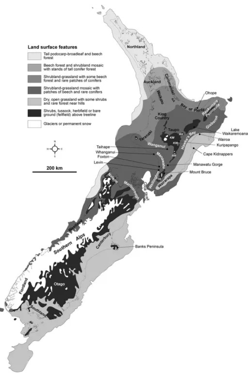
Figure 3 Last Glacial Maximum (c. 1430 cal ka) reconstruction for New Zealand including locations of some places named in the text. The base map is adapted from Alloway et al. (2007). This map illustrates that the land area of New Zealand wasnotably different to that which existstoday asrecently asc. 20 ka ago. This demonstrates how relative sea-level changes as well as the effects of tectonism have had profound influences on the shape of New Zealand and the distribution of its landforms. Abbreviations are: KA, Kaimai Range;
KM, Kaimanawa Mountains; AH, Ahimanawa Range; KW, Kaweka Range; RR, Ruahine Range; TR, Tararua Range.
Downloaded By: [Massey University Library] At: 22:04 20 June 2011
recent geological time. Examination of rocks from this area, both in outcrop and subsurface, clearly illustrates that the landforms currently referred to as ‘North Island’ and ‘South Island’
are geologically young, having only acquired most of their shape in the last half-million years or so. This central New Zealand zone has been subjected to phases of rapid subsidence and sedimentary basin formation, followed by per- iodsof rapid uplift, erosion and mountain building. In addition, active arc volcanism and the productsof these volcanoeshave periodically affected large areasthrough the deposition of extensive ignimbrite sheets and ash fall (Wilson et al. 1995a; Shane et al. 1996b;
Naish et al. 1998; Alloway et al. 2005b; Pillans et al. 2005). We provide an up-to-date review of the geological literature in order to develop a palaeogeographic synthesis, tracking the development of land and the timing and extent of disjunction between islands past and present, which will provide a robust basis for the development and testing of biogeographic hypotheses.
Palaeogeographic reconstruction Approach
New palaeogeographic mapshave been com- piled using a combination of historical and recent information from outcrop mapping, drillholes, seismic interpretation and micro- and macrofossil analysis. The maps therefore summarize the current state of knowledge developed since the pivotal importance of plate tectonicsin the development of central New Zealand’slandscape wasrecognized (e.g.
Walcott 1978, 1987; van der Lingen & Pettinga 1980; Pettinga 1982; Kamp 1986; Ballance 1993; Lewis& Pettinga 1993). While some of the detailsmay change with the addition of new data, the general first-order palaeogeography and timing of tectonic eventsare not likely to change significantly.
Previouspalaeogeographic mapsof central New Zealand for the late Neogene (c. last 5 Ma) have invoked extensive strike-slip faulting,
contraction and block rotation in North Island on the basis of previously published tectonic reconstruction models of the New Zealand micro-continent (e.g. Wellman 1985; Kamp 1986; Lewiset al. 1994; Beu 1995; King 2000;
Bunce et al. 2009). For many yearsit was assumed that large-scale strike-slip faulting (several hundred kilometres) and tectonic rota- tions of similar magnitude to those inferred for South Island also occurred in North Island (e.g.
Wellman 1985; Cutten 1991, 1994). However, more recent studies have demonstrated that there islittle geological evidence for large-scale (20 km) strike-slip displacement in North Island during the late Neogene, and that extensive strike-slip faulting and tectonic rota- tion (608908) isnot required to reconstruct the tectonic framework of central New Zealand (e.g. Beanland et al.1998; Wallace et al.2004;
Nicol et al.2007). Clockwise rotations of c. 458 508 take up much of the margin-parallel (i.e.
parallel to plate boundary) motion at the plate boundary, and most of the margin-normal (i.e.
at right anglesto plate boundary) contraction (80%) is occurring on the subduction thrust (Nicol et al. 2007). Thus, models including large-magnitude strike-slip offset in central New Zealand are inconsistent with current knowledge.
The palaeogeographic mapspresented are drawn relative to the modern New Zealand coastline, and we have made no attempt to deform the coastline to accommodate possible tectonic block rotations, contraction, extension and strike-slip faulting. We acknowledge that such tectonic deformation will have had some influence on the geometry of the study area, but suggest that the amount of deformation is probably small compared to the uncertainties in the palaeogeographic maps. Movement on the large strike-slip faults in central New Zealand (e.g. Wellington, Wairau and Awatere faults) and clockwise vertical axis rotations of the eastern North Island are the most likely source of map distortion due to deformation, but 50 km of strike-slip would be required to significantly distort the palaeogeographic maps
Downloaded By: [Massey University Library] At: 22:04 20 June 2011
and there islittle evidence for this(Nicol et al.
2007). Of the main strike-slip faults, the Well- ington Fault hasaccommodated B10 km strike-slip (Begg & Mazengarb 1996), while ratesof horizontal displacement on the Wairau and Awatere faultsare currently 45 mm/yr (Van Dissen & Yeats 1991). If, as it appears, these rates have remained approximately con- stant since c. 4 Ma on the Awatere Fault (Little
& Jones 1998) and Wairau Fault (Van Dissen &
Yeats1991; Rattenbury et al. 2006), their total horizontal displacements would be no more than 20 km. Similarly, clockwise vertical-axis rotationsof c. 38/Ma appear to have resulted in the east coast in the southern North Island moving 10 to 15 km closer to Mount Taranaki over the last c. 5 Ma (Nicol et al. 2007). This movement wasprimarily accommodated by shortening, which was distributed across the entire island and would probably result in only minor distortion of the palaeogeographic maps.
Four million years ago
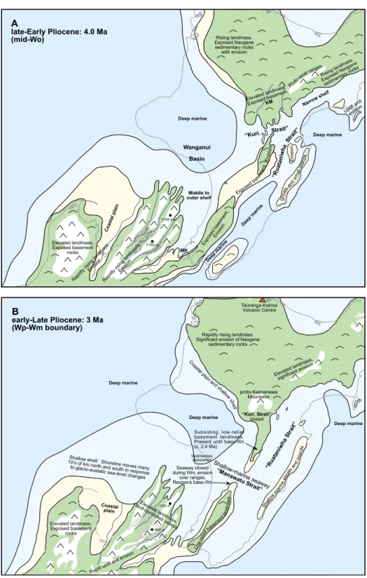
By the Early Pliocene much of the northern North and South islands were exposed as land, although there wassignificant variation in topography. The Southern Alpswere mostly formed by thistime, and their elevation has probably changed little since due to a balance being reached between uplift and erosion rates (Koons1989, 1995; Cox & Sutherland 2007).
Sedimentsproduced through erosion of the Southern Alpsbuilt large alluvial plainswhich, in Canterbury, eventually joined South Island to offshore Late Miocene volcanic islands to form what is today Banks Peninsula. Most of southern North Island was still under water (Fig. 4A). In particular, the Wanganui-Mana- watu area lay in relatively deep water (c. 200 600 m) due to a period of rapid subsidence and basin formation (named the ‘Tangahoe Pull- down’) that commenced at c. 4.8 Ma (Kamp et al.2004). The main effect of this subsidence wasthe formation of the Wanganui Basin, and a dramatic increase in water depth from c. 50 100 m to over 600 m in some areas (Hayton
1998; Kamp et al. 2004). This subsidence was also responsible for the re-opening of a shallow marine seaway (c. 50100 m deep) and asso- ciated deposition across the modern Kaweka Range in the early to mid Pliocene (informally named ‘Kuripapango Strait’; Browne 2004a, b;
Bland et al. 2008). The Kaimanawa Mountains area wasland by thistime, and both basement and Cenozoic cover rockswere eroding from it to be redeposited in adjacent sedimentary basins.
Continued south and east-directed shoreline retrogradation (marine transgression), which had started in the latest Miocene, continued through the Early Pliocene in southwestern
‘North Island’. An east-west orientated shore- line that occurred over the position of central Taranaki in the latest Miocene (Vonk & Kamp 2008) had retreated back to near the site of the modern axial rangesdue to the ongoing devel- opment of the plate boundary. The western Wellington area wasat shelf water depths(c.
50200 m) asindicated by a small inlier of Early Pliocene marine rockspreserved at Ma- kara, near Wellington city (Begg & Mazengarb 1996). The orientation of the shoreline in this area is uncertain, but a shore facing west into the Wanganui Basin appears most likely (e.g.
Nicol, in press). There is no evidence for an east-west marine connection between ‘North’
and ‘South’ islands farther south, and it is also likely that the Ruahine-Tararua range area was an emergent finger of basement rocks, albeit at low elevation (see also Fig. 1B). This means that there was probably no seaway across the Manawatu Gorge area at thistime. Shoalsand small islands were beginning to appear in the easternmost parts of Hawke’s Bay and north- ern Wairarapa due to uplift of the western (inboard) edge of the Hikurangi margin’s accretionary wedge (Pettinga 1980, 1982; Beu et al.1980; Beu 1995; Bland et al.2008).
Three million years ago
At thistime most of the Wanganui area was deep marine and lay under c. 200400 m of
Downloaded By: [Massey University Library] At: 22:04 20 June 2011
Figure 4 (Continued)
Downloaded By: [Massey University Library] At: 22:04 20 June 2011
Figure 4 (Continued)
Downloaded By: [Massey University Library] At: 22:04 20 June 2011
water, and the Manawatu region wasmostly at shelfal water depths (0200 m; Fig. 4B).
Shelfal environmentsalso covered much of the Wairarapa-Hawke’sBay area aspart of the narrow but laterally extensive ‘Ruataniwha Strait’ (after Beu 1995). Continued uplift of the accretionary wedge complex in eastern Hawke’sBay and northern Wairarapa led to the development of an archipelago of small islands and shallow marine shoals, around which carbonate shell banks accumulated (e.g.
Kamp et al. 1988; Nelson et al. 2003; Caron et al. 2004).
Uplift of the King Country area waswell under way by 3 Ma (Pulford & Stern 2004), and most of the northern parts of modern North Island were land by this time (Isaac et al.1994).
Modern topography in the King Country area rarely exceeds400500 m due to natural slope and hillside instability. This instability is a consequence of the poorly lithified and thus easily erodable nature of most of the Neogene surface strata, except in areas where harder basement or limestone are exposed. It is there- fore likely that maximum topography in the King Country area in the Late Pliocene differed little from that of today. The onset of uplift in the King Country recordsthe motif of rapid subsidence followed by uplift that has occurred along the western margin of North Island throughout the Neogene (see Fig. 5; Kamp et al.2002, 2004; Pulford & Stern 2004; Kamp
& Furlong 2006; Furlong & Kamp 2009).
Andesitic and rhyolitic arc volcanoes were active in the southern Coromandel and Kaimai area (Briggset al. 2005) and would have contributed topography, which may have
approached 1000 m in height in places. To the west of the zone of active arc volcanoes, the northern Waikato area comprised a low-lying coastal plain that abutted shallow-marine en- vironmentsin the Port Waikato and South Auckland areas(Isaac et al. 1994; Edbrooke 2001, 2005).
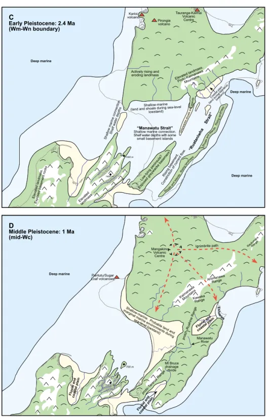
In the south there was significant topogra- phy in the Marlborough area, with large river valleysand mountain rangesof uplifted base- ment rocks. The height of these mountains, as depicted on Fig. 4B, hasbeen inferred by comparing modern topography in the Marlbor- ough Soundswith now-buried basement relief in this area (Nicol in press). The extent of these mountainswassmaller and their elevations lower than that which existed at 4 Ma due to continued subsidence (Fig. 5). Alpine environ- ments may have been existing on these ranges, which were probably part of a large elevated area extending from southern Nelson across to Marlborough. The Wellington area wasprob- ably still geographically part of this ‘South Island’ area, although it most likely comprised low-lying basement hills rather than mountai- nouscountry. A narrow peninsula of low-lying land probably existed in the region of the modern Tararua Range, and wasseparated by a narrow seaway (the ‘Manawatu Strait’) in the Manawatu Gorge area from a finger of low- lying land and shallow shoals that extended over the location of the Ruahine Range. The presence of non-marine to marginal-marine greywacke-derived conglomerate beds(includ- ing pebbly beach deposits) in Waipipian rocks (3 Ma) west of the Ruahine Range near Taihape indicatesthat an erodable source of Figure 4 Simplified palaeogeographic maps(4A, 4 Ma; 4B, 3 Ma; 4C, 2.4 Ma; 4D, 1 Ma) illustrating inferred land area (green), areaspotentially1000 m (white), coastal land (light yellow), shelfal water depths (0200 m; light blue) and deep marine environments(200 m; dark blue), relative to the modern New Zealand coastline. Inverted ‘Vs’ indicate potential mountains, lower symbols indicate hills. Red dashed arrows (D) indicate ignimbrite pathsfrom the Mangakino Volcanic Centre. MK (A) denotesthe location of the Makara inlier, and ‘’ shows location of the Young-1 drillhole. KM (A), Kaimanawa Mountains; ‘Kuri. Strait’, Kuripapango Strait; Wp, Waipipian (3.63.0 Ma); Wm, Mangapanian; Wn, Nukumaruan (2.41.63); Wc, Castlecliffian (1.630.34 Ma). These maps have been compiled from many sources, including Beu et al.
(1980), Nathan et al. (1986), Isaac et al. (1994), McIntyre (2002), Browne (2004b), Bland et al. (2008), Nicol (in press) and unpublished work-in-progress at GNS Science.
Downloaded By: [Massey University Library] At: 22:04 20 June 2011
Figure 5 Schematic topographic profiles showing estimated average topography, sea level, bathymetry and thuspattern of elevation change over time. Bathymetry isderived from palaeogeographic mapsof southern North Island. The general elevation of the King Country area is based on modern topography and assumed natural hillslope stability. Elevation in the Marlborough Sounds area has been estimated from Nicol (in press).Inset:locationsof profilesA-A?and B-B?.
Downloaded By: [Massey University Library] At: 22:04 20 June 2011
greywacke waspresent nearby (Lee et al. in prep). Also, rocks of Waipipian age were probably not deposited over the axial range area in central and lower North Island (Bland et al. 2008), except at Saddle Road, immedi- ately north of the Manawatu Gorge (e.g.
McIntyre 2002). The inference isthat much of the modern axial rangeswere at or above sea level at thistime. An unconformity between late Waipipian (3 Ma) and Nukumaruan (2.4 Ma) rocksin the Saddle Road section (Mc- Intyre 2002) indicatesthat the Manawatu Gorge area was subject to erosion, and was therefore probably land during the Mangapa- nian Stage (c. 3.02.4 Ma).
Rocksof Opoitian (5.33.6 Ma) and Man- gapanian (3.02.4 Ma) age occur in the Kur- ipapango region (Fig. 3), whereasrocksof Waipipian age are absent (Browne 2004a;
Bland et al. 2007). This suggests a period of land, non-deposition, and erosion in the Kuripapango area during the Waipipian, an interpretation supported by the presence of significant erosional unconformities of prob- able Waipipian age (Bland et al. 2008).
A large landmass probably existed over the Raukumara Peninsula by this time. Basement rockswere certainly cropping out at the surface in some areas of this landmass, as shown by the presence of greywacke-derived clasts in adja- cent sedimentary successions. Areas of exposed basement may have had notable relief, although there are insufficient data to allow accurate estimation of heights. Areas of ex- posed Cenozoic rocks were present too, and probably formed hilly country. The Wairoa area (Fig. 3) still lay at significant water depths, although small islands or shoals may have existed in some areas due to fault-related folding and uplift, asindicated by depositional onlap patterns discernable from seismic profiles (e.g. IRBA 1998).
2.4 million years ago
Thistime marksthe position of the Mangapa- nian-Nukumaruan New Zealand Stage bound-
ary during the Early Quaternary. The Ruahine Range area wasunder the ocean, probably in the form of a narrow, shallow marine sill. A seaway across the location of the modern southern Ruahine and northern Tararua ranges at shallow shelf depths existed between the eastern Wanganui Basin and central and south- ern Hawke’sBay area, and separated northern and southern land masses (Fig. 4C). This sea- way represents the Manawatu Strait at its most extensive, and to its north was an area of low- lying shoals and islands. Marine deposition onto mostly ravened (sub-aerially eroded and wave-planed) basement in the axial ranges at this time is illustrated by the presence of basal- Nukumaruan shallow marine limestone in many placesalong the now-uplifted Ruahine and southern Kaweka ranges (Beu et al. 1981;
Beu 1995; Browne 2004a; Lee et al. in prep).
Erosion of basement from growing ranges to the north of Kuripapango isindicated by widespread deposition of greywacke-derived gravelsin western Hawke’sBay in the form of alluvial fans and braided river systems, similar to those present today in Canterbury (Cutten 1994; Bland 2001; Graafhuis2001; Bland et al.
2007, 2008). The Wanganui Basin depocentre had moved south and east during the Pliocene (Anderton 1981), perhapsin a stepped rather than gradual process, and was located near Whanganui City at this time (Nicol in press).
Deposition of sediments from river systems surrounding the eastern margin of the basin wasdirected into thisarea.
The Alexandra Volcanics, located in western Waikato, were erupted between 2.74 and 1.6 Ma (Briggs& McDonough 1990). Karioi volcano, the north-westernmost of the Alexandra volca- nicsgroup (Fig. 3), wasactive between c. 2.5 and 2.3 Ma (Goleset al. 1996). Thisnow deeply eroded mountain would have had many hun- dredsof metresof relief. The stratovolcano of Mount Pirongia wasalso formed at thistime, and would have had an elevation of over 1000 m at its summit. These volcanic edifices were surrounded by a low-relief coastal plain (Goles et al.1996). The King Country, located south of
Downloaded By: [Massey University Library] At: 22:04 20 June 2011
these volcanoes, continued to rise in response to mantle-driven thermal uplift (Kamp et al. 2004;
Pulford & Stern 2004). Thiswave of uplift followed a period of subsidence and resulted in erosion (Fig. 5). Elevation in this part of central North Island was probably of the order of several hundred metres due to natural slope instability, preventing the generation of high mountainous topography. The river systems draining thislarge area of juvenile topography delivered significant volumes of sediment to adjacent sedimentary basins, as is evident from the rapid progradation of the continental shelf in Taranaki-King Country area (e.g. Hansen 2003).
By about 1.5 Ma, uplift of the Mount Bruce block in central Wairarapa had closed off the Ruataniwha Strait at itssouthern end, although marine deposition still occurred in parts of Wairarapa and Hawke’sBay into the late Quaternary (Field et al. 1997; Begg & Johnston 2000; Lee & Begg 2002; Figs. 2, 4C). The uplift at Mount Bruce indicatesa change in displace- ment along faultsin thisarea. It also initiated a drainage divide east of the proto-axial ranges that resulted in the Manawatu River system developing to the north of the divide and the Ruamahanga River system to the south. Most of the Wanganui-Manawatu area wasat shelf to marginal-marine water depths.
Rapid uplift wasalso occurring farther south in the Nelson-Marlborough area. A large, low-gradient coastal plain was located in the Tasman Bay area due to the large rivers that flowed through the Moutere Depression.
These rivers drained adjacent mountain ranges that at thistime were rapidly rising and eroding. Substantial rivers still existed in the region of the modern Marlborough Sounds, draining thismountainousarea of high topo- graphy (1000 m).
Rhyolitic volcanism in Mangakino Volcanic Centre of the Taupo Volcanic Zone (TVZ; Fig.
4D) had commenced by c. 1.7 Ma, with the focusof arc-related volcanism migrating from the Tauranga-Kaimai centre to the modern TVZ (Carter et al. 2003; Briggset al. 2005).
This transition was apparently seamless and
without obviousbreaksor changesin major element composition of volcanic glass. The resulting volcanism from the TVZ since this time hasmade it arguably the most active and productive rhyolitic system in the world (Wilson et al. 1995b; Carter et al. 2003;
Alloway et al. 2005b).
One million years ago
By 1 Ma (Fig. 4D), the Kaimanawa Mountains and Kaweka Range were reasonably well established, and it is likely that some alpine habitat already existed in the northern parts of thisarea (Fig. 4D). Rapid uplift and formation of the Ruahine and Tararua rangesin their current form commenced at about 1 Ma (Beu et al. 1981; Erdman & Kelsey 1992; Heerdegen
& Shepherd 1992; Shane et al. 1996b; Lee &
Begg 2002), although some uplift in this region had probably been initiated by 1.5 Ma (Erdman
& Kelsey 1992; Lee & Begg 2002; Nicol et al.
2002; Bland et al. 2008). Uplift here wasa response to the inception of significant displa- cement on the Wellington, Wairarapa and Ruahine faults, possibly due to increased con- vergence across the North Island fault system.
The growth of these mountain ranges is in- dicated in the sedimentary record by the sudden influx of large volumesof coarse-grained grey- wacke clasts into adjacent basins to the west and east (e.g. Okehu, Mangamaire and Kid- nappersgroups; Fleming 1953; Kingma 1971;
Kamp 1978; Townsend et al. 2008; Lee & Begg 2002; Lee et al. in prep). Some constraint on the timing of uplift of these ranges prior to c. 1 Ma isprovided by the presence of multiple TVZ- derived ignimbritesin KidnappersGroup rocks in Hawke’sBay, which must have been able to flow across the position of the developing mountains(Fig. 4D; e.g. Shane et al. 1996a, b). Continued uplift of the Kaweka Range was probably also occurring during this time, and eroded gravelsfrom the range contributed to the alluvial plain developing along the western margin of Hawke’sBay. The King Country and Wairoa areas consisted of extensive hill
Downloaded By: [Massey University Library] At: 22:04 20 June 2011
country, with topographic relief probably simi- lar to that of today.
Much of Hawke’sBay wasland by 1 Ma, except for a small area of marginal-marine deposition at Cape Kidnappers (Kingma 1971; Kamp 1978; Shane et al. 1996a). The axial ranges, particularly the Ruahine Range, were rapidly rising, and large volumes of sediment were derived from them (Figs. 4D, 5). A braid plain built out from the rising mountains in response to the uplift and erosion, and probably resembled the modern Heretaun- ga Plainsin itsgeneral form and character.
Uplift in the east of southern Hawke’s Bay and northern Wairarapa during the Early Quatern- ary caused the hitherto east-flowing Manawatu River to drain westwards through the area that would become the modern Manawatu Gorge.
Uplift along the western side of the Wellington Fault from 1 Ma in the region of the gorge caused ponding and the formation of a lake (Shane 1991; Lee & Begg 2002), which wasthen drained towardsthe Tasman Sea. Uplift of the Tararua and Ruahine rangeswest of the Well- ington Fault wasnot rapid enough to defeat the river, which maintained its westward course to the Tasman Sea, and cut the Manawatu Gorge.
The Wanganui-Manawatu area, into which the proto-Manawatu and other rivers(e.g.
Rangitikei, Whanganui) were draining, com- prised a combination of low-lying land and marginal marine estuaries as indicated by out- cropping strata (Fleming 1953; Abbott &
Carter 1997, 1999; Townsend et al. 2008). The Wanganui Basin depocentre had moved south, and by 1 Ma lay off the coast of Levin and Foxton (Nicol in press). The proto- Marlborough Soundsat the southern end of the Wanganui Basin continued to be pulled down, and the river valleysin thisarea became flooded by the Tasman Sea, yielding the flooded valleys or ‘sounds’ seen today. The high hillsthat surrounded the river valleysof the Marlborough Soundsmay have had up to c.
1400 m of topographic relief (Nicol in press).
By 1 Ma the Wanganui area had ceased
subsiding and began to rise, reflecting the arrival of the uplift part of the sinusoidal wave following subsidence (Fig. 5). The change from subsidence to uplift is marked by the formation of well-developed flightsof marine terracesthat are preserved in the Wanganui South Taranaki areas(e.g. Pillans1990a, b;
Townsend et al. 2008).
Andesitic volcanism in the Taranaki region commenced around 1.7 Ma (Stipp 1968; Town- send et al. 2008)*the remainsof which are Paritutu and the Sugar Loaf Islands in the New Plymouth area. These volcanic centres are the southern part of a southward-developing chain of volcanoesthat had lain off western North Island during the Neogene (King & Thrasher 1996; Thrasher et al. 2002; Giba et al. 2010).
The Paritutu-Sugar Loaf volcanoeswere prob- ably not connected to the proto-North Island, although they most likely formed emergent volcanic islands. Egmont volcano (Mount Tar- anaki) became active much more recently (by 130 ka, Alloway et al. 2005a), although the upper cone ismostly younger than 7000 years old.
Prior to about 2 Ma the TVZ had not formed (Wilson et al.1995b; Carter et al.2003, 2004) and the extensive modern plains of the Bay of Plenty area, which are partly the product of crustal rifting and voluminous volcaniclastic deposition, probably did not exist. Marine macrofossils indicate that the Ohope area, near the eastern edge of the modern TVZ, wasat shallow marine depths during the Early Quaternary (Beu & Maxwell 1990). To the west of the axial ranges, the andesitic stratovolcanoes of the southern TVZ (i.e. Ruapehu, Tongariro) had not yet formed, although volcanic activity was well established by c. 1 Ma in the Mangakino area northwest of present-day Lake Taupo (Fig. 4D; Wilson et al.
1995b). A series of large rhyolitic eruptions from the Mangakino volcanic centre resulted in the emplacement of ignimbritesand volcaniclastic deposits over much of central North Island (Wilson et al.1995a).
Downloaded By: [Massey University Library] At: 22:04 20 June 2011
The oldest volcanic feature in the Tongariro volcanic centre isMount Hauhungatahi (Fig.
1). Lavasfrom thismountain have been dated at c. 800 ka (Hackett 1985; Cameron et al.2010), and topographic profilesacrossthe mountain suggest that the now-eroded summit vent may have been over 2000 m asl (Hackett 1985). The oldest exposed parts of Mount Tongariro, a volcanic complex consisting of several over- lapping volcanoes, are c. 275,000 years old (Hobden et al. 1996). Mount Ngauruhoe, a cone on the southern flank of the Tongariro volcanic complex, isonly c. 2500 yearsold. The oldest parts of Mount Ruapehu have been dated at 245 ka (Stipp 1968; Gamble et al.2003).
By the time of the eruption of the ignim- britesof the silicic Whakamaru group at around 0.34 Ma, the Kaimanawa Mountains and Ahimanawa Range were in much their present form. These mountains created a bar- rier to emplacement of these ignimbrites, which overlie greywacke in thisarea (Townsend et al.
2009).
The estimated timing of formation of Cook Strait at c. 500 ka (Lewis et al. 1994) suggests that the Wellington area was, until this time, still connected to Marlborough via a low-relief land bridge between areasof mountainous topography. Thisland waslikely to have been relatively narrow with sedimentary basins on its northwestern and eastern sides. The developing central ‘New Zealand’ landmasses at 1 Ma may have comprised a single large island with a low, narrow isthmus in the Wellington area (Fig.
4D). After about 500 ka Cook Strait had formed the modern partition between ‘North Island’ and ‘South Island’, although connec- tions between the two islands may have existed during times of low sea level (e.g. glaciations;
Fig. 3).
Discussion
Tectonic activity hasbeen of primary signifi- cance for New Zealand since the inception of the present plate boundary. The shape and topography of ‘New Zealand’ since this time
haschanged markedly astectonic activity proceeded, from a series of very small islands into the landmasses present today. However, the extent of land area at the start of the Miocene remains somewhat uncertain despite past attempts at reconstructions (e.g. Fleming 1975; King et al. 1999; King 2000), due to the paucity of information on which to form a basis for earliest Miocene palaeogeography (Landis et al. 2008). Southern North Island has in particular been subjected to and remains a focus of intense tectonic processes. The infer- ence that tectonic displacement of land areas hashad an important role in the distribution of the New Zealand and, in particular, South Island, biota has been largely rejected (McGlone et al. 2001; Wallis& Trewick 2001;
Trewick & Wallis2001). Even so, early infer- ence that tectonic movement of terrestrial surfaces (and biota) might have been important in generating the contrast between southern and northern North Island endemicity (McGlone 1985; Rogers1989) wasdependent on the assumption of substantial horizontal strike-slip faulting in North Island. Such a view originated from early study of tectonics that inferred that similar amount of strike-slip movement occurred in North Island as in South Island (Suggate et al. 1978; Wellman 1985;
Rogers1989; Cutten 1991, 1994). Although some continue to ignore modern geological mapping and fault analysis, it is now well recognized that total strike-slip displacement in the North Island fault system in the Plio-Pleistocene has been minimal (B20 km;
e.g. Beanland et al.1998; Berryman et al.2002;
Bland & Kamp 2006; Nicol et al.2007; Bland et al. 2008). An important corollary of thisis inference of the timing of formation and extent of past seaways in the region. The focus on a single large feature that persists across central North Island throughout much of the Neogene (e.g. Kamp 1982, Beu 1995; Bunce et al.
2009) doesnot properly accommodate the outcropping geology (Erdman & Kelsey 1992;
Lee & Begg 2002; Bland et al.2004, 2007, 2008;
Browne 2004a; Bland 2006; Townsend et al.
Downloaded By: [Massey University Library] At: 22:04 20 June 2011
2008; Vonk & Kamp 2008; Lee et al. in prep) and drillhole records(e.g. Leslie 1971a, b;
Johnston & Francis 1996; Johnston & Langdale 2000) or consider the detailed geological in- vestigations from fault and tectonic analysis (e.g. Cashman et al. 1992; Beanland et al.1998;
Wallace et al.2004; Nicol et al.2007).
Understanding the palaeogeography and thusbiogeography of the region dependson recognition that the tectonic plate boundary between the Australian and Pacific plates oper- atesin very different waysthrough the New Zealand micro-continent. In particular, large amountsof horizontal movement have occurred in South Island during the Neogene, but much less so in North Island, whereas volcanic activity during the Plio-Pleistocene has been substantial in North Island, but absent in South Island, and arc volcanism is virtually restricted to North Island (except for Solander Island;
Turnbull et al.1993). Furthermore, the present- day location of the separation between North and South Islands is in the area where the transition from subduction of Pacific Plate into predominantly strike-slip displacement occurs.
Underlying thisisthe north-south migra- tion of a wave of uplift, subsidence and sedimentary basin formation, and then basin inversion that has occurred along the western North Island margin through the Neogene (Stern et al. 1992; Kamp et al. 2004; Pulford
& Stern 2004; Proust et al. 2005; Fig. 5). The Plio-Pleistocene geological evolution of the western margin of central New Zealand repre- sents one period of this wave. The driving force behind this process is certainly linked in some way to the ongoing development of the plate boundary through New Zealand, although the exact mechanism remains unresolved (e.g.
Kamp et al.2004; Pulford & Stern 2004; Nicol et al. 2007; Stagpoole & Nicol 2008; Furlong &
Kamp 2009). The most recent expression of this
‘wave’ isthe formation of land in southern North Island (such as Wanganui), and the separation of modern ‘North’ and ‘South’
islands. Uplift of Wanganui-King Country is the back of the wave, with the drowning of the
Marlborough Soundsrepresenting the wave trough. At present the wave front is considered to lie in the Kaikoura-Nelson area.
In the following sections we briefly discuss some of the palaeogeographic issues and fea- tures that are illustrated by the maps presented in thispaper. These featureshave implications for biogeography because they provide our best opportunity to estimate the availability and quality of terrestrial habitat in the central New Zealand region during the late Neogene. Bio- geographic inference hastended to view New Zealand as a fixed entity and of necessity has applied simplified notions of the influence of Quaternary climate change, tectonic displace- ment of land surfaces and marine transgression (e.g. Fleming 1962, 1975; McGlone 1985; Ro- gers1989; McGlone et al. 2001 and references therein). Studiesthat draw on ecological (e.g.
habitat preference, dispersal capacity) and population genetic/phylogenetic information have the potential to test alternative hypotheses about the driving forcesof taxon distribution, but have been limited by the availability of detailed palaeogeography (see McGlone et al.
2001; Wallis& Trewick 2009). For instance, the young age of southern North Island coincides with the period of greatest climatic change in the second half of the Pleistocene. It would therefore be useful to know when, where and how much habitat islikely to have existed through thisperiod. Understanding the poten- tial influencesof climate change on terrestrial taxa can only really be achieved with inclusion of information about land area and topography over time.
Marine seaways
At least three marine seaways have existed across the trend of axial ranges during the Neogene, including the ‘Manawatu Strait’, the
‘Kuripapango Strait’, and a probable strait in the Lake Waikaremoana area (Figs. 4, 5). In general, the age of these seaways appears to decrease towards the south and is consistent with the southward propagation of the plate
Downloaded By: [Massey University Library] At: 22:04 20 June 2011
boundary through time and space, and the southward progression of volcanism, mountain building and increased strike-slip faulting dur- ing the past c. 5 Ma. The Manawatu Gorge (and the Late Pliocene ‘Manawatu Strait’) lies very close to where the Wellington Fault bifurcatesinto the Ruahine and Mohaka faults (Langridge et al. 2005). The older Late MioceneEarly Pliocene ‘Kuripapango Strait’
liesnear the point where several major faults (the Kaweka, Ruahine and Glenross faults) intersect (Browne 2004a; Bland 2006). Even older seaways, such as a possible Middle Miocene connection in the Lake Waikaremoana region, also coincide with an area where major faultsbifurcate, in thiscase the Mohaka, Whakatane and Waimana faults. The positions of late Neogene east-west seaways across the modern axial rangesmay have been linked in some way to structural dynamics and the transition of displacement from one structure onto another in these zones of fault interac- tions. Cook Strait, the modern-day marine connection from east-west across the trend of the axial ranges, lies near the southern termina- tion of subduction along the Hikurangi margin, where plate boundary convergence transfers onto oblique-slip the Marlborough fault system and on to the Alpine Fault (Fig. 1).
The oldest cover rocks overlying basement in the area about the Manawatu Gorge are coarse-grained limestone of latest Miocene (late Kapitean, c. 6.55.3 Ma) age, and Early Pliocene mudstone (c. 5.3 Ma; Lillie 1953;
Beu 1995; Lee et al. in prep). These rocks crop out to the east of the axial ranges. To the west of the ranges, however, the stratigraphic record contained in the Young-1 drillhole, together with seismic correlations, shows that marine transgression over basement near the gorge did not occur until the Late Pliocene (Waipipian, c. 3.6 Ma; Superior Oil Co. of NZ Ltd 1942; Uruski 1998; Townsend et al. 2008).
The apparent absence of any cover rocks older than Late Pliocene (Waipipian) across the axial ranges in the Manawatu Gorge area is consis- tent with the presence of land between Hawke’s
Bay and Manawatu during the Late Miocene and Early Pliocene (Figs. 4A, 4B). This is also supported by the absence of strata older than Late Pliocene in the subsurface of Wanganui Basin west of the gorge (Uruski 1998). Coarse- grained Late Pliocene (Waipipian) rockson the southern end of the Ruahine Range provide the first evidence of a marine breach across the gorge area, consistent with the age of onlapping rocksin the Young-1 area (Townsend et al.
2008).
The importance of the ‘Manawatu Strait’ as a single topographic entity, and barrier to dispersal, during the Neogene has probably been overplayed in the past. The key character- istic of the Plio-Pleistocene seaways discussed in thispaper isthat they were moderately short- lived features, typically lasting for no more than c. 25 Myr before they were inverted.
Once a seaway was closed due to uplift it was replaced by another one farther south along the trend of the modern axial rangesand North Island fault system within 12 Myr. The Kuripapango and Manawatu straits were also fairly narrow (B20 km wide). Outcropping geology preserved around what would have been the margins of these seaways illustrates that they did not attain the dimensions shown in previouspalaeogeographic maps. Thiscon- trasts strongly with the hypothesized single, very wide (100 km) and long-lived (5 Ma) strait of previous authors that is inferred to have existed throughout the Neogene (e.g.
Kamp 1982; Beu 1995; Bunce et al.2009).
Manawatu River
The modern Manawatu Gorge at present separates the Tararua and Ruahine ranges, and occupiesthe probable centre of the late Neogene ‘Manawatu Strait’. The Manawatu River flowsthrough an antecedent gorge across the trend of the North Island axial ranges. The river itself is somewhat unusual in that its catchment drainsa large part of the eastern side of the North Island axial ranges, yet it crosses the North Island main divide and
Downloaded By: [Massey University Library] At: 22:04 20 June 2011
disgorges into the Tasman Sea on the western side of those same ranges. At some point the proto-Manawatu River drained to the east, but due to progressive uplift of the eastern margin of Hawke’s Bay during the Late Pliocene it wasdiverted towardsthe west. The modern drainage pattern indicatesthat the river was already flowing across the site of the gorge to the west coast before uplift occurred in thispart of the axial ranges. The combined flow of river systems draining the northern Tararua and southern Ruahine ranges was sufficient to enable the river to continue down-cutting through the rising mountains, albeit at a structural low point, and for the Manawatu River to maintain its course to the west coast (Heerdegen & Shepherd 1992; Lee & Begg 2002).
Wellington: a foot in both camps
The present form and disjunction between New Zealand’s‘North’ and ‘South’ islandsisgeolo- gically a very young feature (B0.5 Ma; Lewis et al. 1994). For much of the late Neogene (c. 8 Ma) partsof the Wellington area have been part of a ‘South Island’ rather than a ‘North Island’, linked to the south by low-lying land across what is now Cook Strait. The oldest cover rocksknown overlying basement in the Wellington region form a small erosional onshore remnant of Late Eocene to Oligo- cene-aged strata at Otaihanga, near Parapar- aumu. At Makara near Wellington City a small remnant of Early Pliocene shelfal rocks indi- cates that marine transgression over a sub- aerially eroded and wave-planed (ravened) basement surface occurred in this area during the Opoitian (5.33.6 Ma; Begg & Mazengarb 1996; Begg & Johnston 2000). Apart from these two areasof outcrop, the apparent absence of any cover rocksolder than Quaternary over- lying basement in the Wellington area suggests that the region hasbeen above sea level (subaerial) for much of the latest Neogene.
The presence of the Manawatu and Kuripa- pango straits in the late Neogene means that
the Wellington area remained largely uncon- nected to the rest of ‘North Island’ until at least the middle Quaternary (c. 1 Ma) when the North Island axial ranges were uplifted.
While the nearby Marlborough Sounds underwent subsidence in the late Quaternary (Hayward et al. 2010; Nicol in press) associated with a 50 km southward step in the Wanganui Basin depocentre at c. 1.5 Ma (Fig. 5), the Wellington area remained mostly as land due to uplift on the Ohariu, Wellington, and Wairar- apa faults.
Nelson-Marlborough, and the Ruahine-Tararua ranges: alpine zones in central New Zealand In contrast to the axial mountain ranges in South Island (e.g. Southern Alps, Kaikoura ranges) that were largely in place since the latest Miocene (Cox & Barrell 2007; Cox & Suther- land 2007), most of the axial mountains in southern North Island formed in latest Pliocene and Quaternary time (Beu et al.1981; Erdman
& Kelsey 1992; Beu 1995; Lee & Begg 2002;
Bland et al. 2008). Thisimpliesthat zonesof alpine habitat and thustheir constituent flora and fauna could not have existed here until some time after 1 Ma.
Land has existed in northwest Nelson and partsof the northern Marlborough area since the Late Miocene (Rattenbury et al. 1998;
Nicol in press), and it is possible that some alpine zones have existed there for several million yearsat least. Thisinterpretation is supported by south-directed onlap of marine sedimentary rocks onto ravened basement in Wanganui Basin, as revealed by seismic profiles (e.g. Uruski 1998; Proust et al. 2005; Nicol in press). Topography in the northern Marlbor- ough area was controlled by a series of faults, forming mountain rangesseparated by deep river valleys, similar to the Seaward and Inland Kaikoura ranges, and the Awatere and Clar- ence riverstoday. Topographic relief in these mountainsmay have been asgreat asc. 2000 m, although thisisdifficult to quantify. Since the end of the Miocene these mountains have
Downloaded By: [Massey University Library] At: 22:04 20 June 2011
steadily reduced to their present elevations (up to c. 1500 m) due to downwarping and erosion on the southern edge of Wanganui Basin (Nicol in press; Fig. 5).
Taupo-Tongariro volcanics
Arc volcanism has occurred in ‘North Island’
since the inception of the through-going plate boundary in the earliest Miocene (Ballance 1993; Isaac et al. 1994), and has progressively moved south during the Neogene to its present location in the Taupo-Taranaki area in response to continued subduction of Pacific Plate (Wilson et al. 1995b; Stern et al. 2006). Subduction of Pacific Plate beneath Australian Plate to the east of ‘North Island’, off the northeastern North- land coastline, has possibly been occurring since the middle Eocene (Stagpoole & Nicol 2008) and almost certainly since the Oligocene (King 2000;
Nicol et al.2007). The modern volcanic arc lies in the Taupo-Rotorua area, with backarc vol- canism in western Taranaki. Volcanism has migrated south through the Northland-Coro- mandel-Tauranga areasduring the Neogene, and reached its present position in the TVZ during the past c. 2 million years (Carter et al.
2003). North Island volcanism is, in terms of volume, a minor although highly visible surficial consequence of the same tectonic processes that have produced North Island’s mountains, sedi- mentary basins and fault systems. The modern TVZ stratovolcanoes (Tongariro, Ngauruhoe and Ruapehu volcanoes), as well as Mount Taranaki, have formed since c. 0.28 Ma, and their influence on Neogene palaeogeography in termsof landmassand habitat generation are relatively small. However, the presence of Mount Taranaki and deposits from older volca- noes(e.g. Pouakai, c. 0.25 Ma; Kaitake, c. 0.5 Ma) contributed much of the material forming the Taranaki Bight aswell asarmouring the Taranaki coastline against erosion (Alloway et al. 2005a). Large-scale eruptions, particularly those from rhyolitic volcanoes such as Manga- kino, Whakamaru, Taupo and Okataina, have probably impacted on biogeography. For
example, the late Quaternary Oruanui eruption, which formed Lake Taupo c. 27,000 cal yr ago, ejected more than 1000 cubic kilometresof material, depositing ash from Taranaki to Chatham Island with thicknesses of up to 200 m in central North Island (Pillans et al. 1993;
Wilson 2001).
Wanganui Basin
Wanganui Basin is a geologically young feature located in the southwest part of North Island (Fig. 4), of which about one third hassince been uplifted to form land. The basin formed as a separate depocentre at about 4.8 Ma due to a major tectonically driven lithospheric-scale pull- down (Kamp et al. 2004), and since this time it hasaccumulated up to 5 km of marine-domi- nated rocks (Proust et al. 2005; Townsend et al.
2008). The basin comprised an extensive area of marine environmentsover what isnow south- western North Island, and much of this has only emerged asland in the past 1 Ma (e.g. Pillans 1990a, b; Figs. 4, 5). This has importance for biogeography, as the presence of the basin limits the area of terrestrial habitat available in this part of central New Zealand until geologically recently. Because of its gradual uplift, the Wanganui Basin contains an exceptionally well-preserved stratigraphic record of late Neo- gene global eustatic sea-level changes (e.g. Beu
& Edwards 1984; Naish & Kamp 1997; Naish et al. 2005), reflecting past orbitally controlled (Milankovitch) cycles associated with climate cycling during the Pleistocene.
Quaternary sea-level change and the last glacial maximum (LGM)
The record of sea-level change suggests that global ocean volume changeswill have had significant influences on the size of landmasses in the central New Zealand area during the Plio-Pleistocene. The effects of orbitally con- trolled (Milankovitch cycles) glacial events have been variably preserved in late Neogene (late Miocene-Recent) rocksin New Zealand.
Downloaded By: [Massey University Library] At: 22:04 20 June 2011
The character of the sedimentary response to these sea-level oscillations has been well docu- mented in Wanganui Basin and also parts of Hawke’sBay and Wairarapa (e.g. Vella 1963;
Beu & Edwards1984; Naish & Kamp 1997;
Haywick et al. 1992; Abbott & Carter 1997, 1999; Haywick 2000; Vonk et al. 2002; Bland et al. 2004; Caron et al. 2004; Naish et al. 2005).
Although there islittle evidence of terrestrial ice affecting North Island prior to the Late Pleis- tocene, the interplay of land elevation and extent, sea level change and climate are likely to have influenced biogeography (McGlone et al. 2001). The distribution of land during glacial stages is most readily estimated for the LGM c. 1430 cal ka ago, with the shoreline during the LGM approximated by the modern 120 m bathymetric contour (Fig. 3). North Island was therefore probably connected to South Island at this time, although the extent of this‘land-bridge’ isuncertain astidal chan- nels may have persisted in some areas. North IslandSouth Island connections could have existed during some earlier Pleistocene glacials, but extensive connection through the Wanga- nui Basin is unlikely before 1 Ma.
Conclusions
New palaeogeographic mapspresented in this paper illustrate the general positions of land areas, estimates of their topography and bounding seaways for the latest Neogene (Pliocene-Pleistocene). These maps show that the land masses known as ‘North’ and ‘South’
islands are geologically young features, and that large parts of southern North Island have emerged from a marine environment only in the past 1.5 Ma. This contrasts with nearby north- ern South Island, much of which has existed as land with significant relief through the Plio- Pleistocene, and in some parts since at least the latest Miocene. High mountains in the area of the Marlborough Sounds have subsided since thistime. Much of the area that isnow shelf off the Nelson coastline was part of an extensive coastal plain crossed by large rivers draining
the rising mountainous interior of northern South Island (Fig. 4). This coastal plain has been progressively drowned due to a southward propagating wave of subsidence that is contig- uous with subsidence affecting the Marlbor- ough Sounds(Stern et al. 1992; Proust et al.
2005; Nicol in press; Fig. 5).
Although Cook Strait isa geologically young feature, it marksthe current southern boundary of an area of intense but geologically recent activity spanning hundreds of kilo- metres. In pre-Pliocene times the two main islands of New Zealand were spaced further apart and the landscape of the intervening area hasdeveloped recently. On the whole, land has extended southwards during the last 4 million yearsfrom ‘old’ North Island asthe Wanganui Basin was infilled and uplifted. This was balanced to some degree by subsidence of northern South Island, resulting in the drowned valleys (sounds) of Marlborough. Terrestrial connection between the two main islands is likely to have been tenuousor absent until late Pleistocene glacials when uplift of southern North Island was supplemented by climate- induced sea-level changes (Fig. 3). At other times, connections would probably have been by narrow and very low-lying isthmuses. It is therefore likely that on the whole, plantsand animals came to occupy southern North Island by range expansion primarily from the north, thus sustaining the North Island biotic char- acter.
The late Pleistocene is the time when the most land area was available in southern North Island for colonization. The lack of significant terrestrial habitat to occupy (and speciate with- in) before this time provides the simplest explanation for low taxon endemicity in this region (Rogers1989). Furthermore, observa- tionsfrom intraspecific animal phylogeography support the inference of recent occupation of the region (e.g. stick insects, Buckley et al.
2009; Morgan-Richardset al. 2010), and recent bridging of Cook Strait (e.g. Hemideina tree weta, Galaxiid fish, Paranephrops freshwater crayfish; see Wallis & Trewick 2009) is also
Downloaded By: [Massey University Library] At: 22:04 20 June 2011
consistent with young landscape formation and connection (Fig. 3). Although the distribution and diversity of vegetation has been attributed largely to climatic variation in the Pleistocene (McGlone et al. 2001), it must be acknowledged that distinguishing climatic and geomorpholo- gical effectson habitat availability will be difficult asthey coincide in time. Indeed, increasingly detailed data indicate more wide- spread persistence of vegetation types through New Zealand during episodes of cooler climate (e.g. Shepherd et al. 2007).
A potential source of endemism in southern North Island is the archipelago that existed in the Hawke’sBay/Wairarapa area during the late Neogene. Although undoubtedly some islands were subsequently submerged after their formation, the Te Aute limestones on the east coast of Hawke’s Bay and Wairarapa initially emerged as islands from the sea in late Pliocene- early Pleistocene time (e.g. Beu et al. 1980; Beu 1995; Harmsen 1985; Nelson et al. 2003; Bland et al. 2007, 2008). It is possible that these islands were colonized by the ancestors of the few species endemic to the area now (e.g.
Hawke’sBay tree weta, Morgan-Richards 1995). Alternatively, local species may have colonized after land connection occurred and subsequently been extirpated elsewhere.
The Wellington area wasgeographically part of eastern Marlborough (and thus South Island) for several million years prior to the formation of Cook Strait about 500 ka (Lewis et al. 1994). Distributions of some plants and animals are consistent with this (Rogers 1989;
McGlone 1985), although such distribution patternsmight also have been achieved by expansion during Quaternary land connection.
More compelling are examplesof local ende- micswithin the Wellington area that are more closely related to other species in Marlborough/
Nelson than those in North Island (e.g. the ground wetaHemiandrus bilobatus; Pratt et al.
2008; Fig. 2).
The uplift of the Tararua and Ruahine rangesfrom c. 1 Ma, coupled with the emergence of the Wanganui and East Coast sedimentary
basins during the Quaternary, resulted in the development of North Island in its present form.
These ranges provide much of the alpine habitat of North Island, and their youth is consistent with shallow diversity within species that occupy them and other North Island alpine sites (e.g.
Sigaus grasshopper, Trewick & Morris 2008;
Kikihia cicada, Marshall et al. 2009), and low North Island alpine endemicity compared even to the South Island alpine environment devel- oped during the Pliocene (e.g. Rannunculus buttercups, Winkworth et al. 2005; see also Fig. 2).
Volcanic activity in the TVZ hasprobably had local effectson biogeography, primarily through the extensive deposition of ash. The last Taupo eruption is probably implicated in many ways, such as the beech gap between Mount Ruapehu and Taranaki, secondary contact of Auckland tree weta chromosome racesby Lake Taupo (Morgan-Richardset al.
2000), and the comparatively low diversity of freshwater fish around Lake Taupo (McDowall 1996). The abrupt change in endemicity near Taupo (Fig. 1) may relate to thisvolcanic activity but is possibly also a signature of an older biota on the older ‘North Island’ com- pared to younger land to the south.
The Kaimanawa Mountainsare the longest- lived area of elevated topography in central North Island, having existed since at least the earliest Pliocene (Fig. 4). Seaways across the Kuripapango area in the latest Miocene and Early Pliocene, and farther south around Manawatu in the Late Pliocene provided mar- ine connections between east coast and west coast sedimentary basins, but may have been limited barriersto terrestrial exchange. Ephem- eral shoals and fingers of land have occupied the sites of the modern axial ranges, and these areashave been periodically breached by these east-west orientated seaways.
North Island biogeography has therefore been strongly influenced by a succession of youthful processes impacting on diversification and extinction; small, ephemeral and low lying land areashave been transected by marine
Downloaded By: [Massey University Library] At: 22:04 20 June 2011