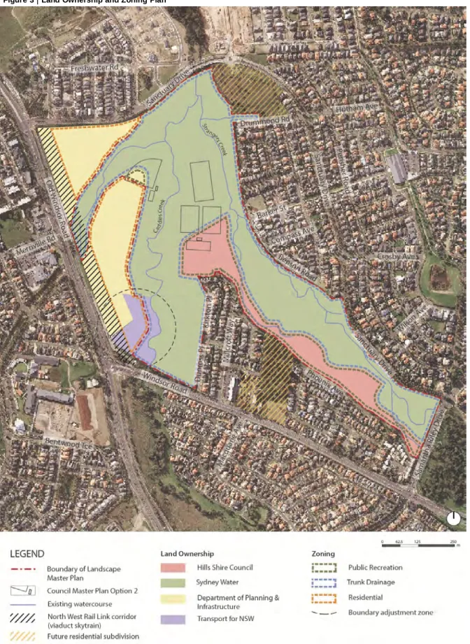
Draft Documents\6.1 Reports\Master Plan Report\Landscape Master Plan Report_Draft 2 for Public Exhibition 20131211.docx. This report supports the development of a master landscape plan for the Sydney Water Trunk Drainage Land (TDL) within the Rouse Hill Development Area (RHDA) and includes adjacent land owned by The Hills Shire Council (THSC), the NSW Department of Planning and Infrastructure (DP&I) and Transport for NSW (TfNSW). While the majority of the master plan area (hereafter the site) is owned by Sydney Water, parts of the area are also owned by THSC, DP&I and TfNSW.
Sydney Water engaged the AECOM and Aurecon Joint Venture (AAJV) to develop the Landscape Master Plan. As part of this process AAJV aims to complete the Landscape Master Plan by the end of November 2013 for use by Council. The Landscape Master Plan/Draft Master Plan for the sports complex will be put on public exhibition from December 2013 to the end of February 2014.
ISSUES AND
OPPORTUNITIES
- Soils
- Flooding
- WSUD
- Safety
- Endangered Ecological Communities
- Red-crowned Toadlet
- Other Threatened Species
- Regionally Significant Species
- Feral Fauna and Weeds
- Bushfire
- Aboriginal Heritage
- European Heritage
- Access
- Infrastructure
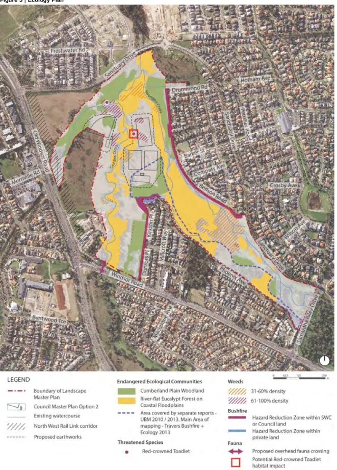
Actively eroding watercourses – expected increase in scour around playing fields Amber Tiles site – fill within the riparian corridor affecting flood levels. The modified flow characteristics of the catchment due to large impervious areas around the site resulted in a decrease in soil permeability and infiltration. Masked owl, grey-headed flying fox, eastern free-tailed bat, turquoise parrot identified on site Cumberland Plain Land Snail - 'Expected to occur' on site / existing suitable habitat present.
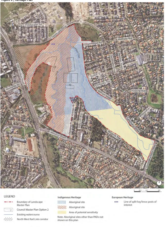
There are many weed-infested areas in the area as shown in Figure 5, especially blackberry, bride's rowan, great privet and green cestrum. As part of the master planning process, Sydney Water commissioned an Aboriginal Due Diligence Assessment for the site. The current assessment has also identified an area of archaeological sensitivity covering much of the rest of the site.
A number of old split beam fence posts remain to the north of the site - no specific heritage listing - potential to retain as a relic of interest. Timing of access to baseball diamond dependent on housing development to DP&I land Watercourse obstructs pedestrian east-west access across site.
LANDSCAPE MASTER PLAN
- Introduction
- Playing Fields
- Interpretation
- Access / Open Space
- Traffic
- Bushland
- Bushfire Risk Management
- Hydrology
- Water Quality
- Management
- Further Assessment
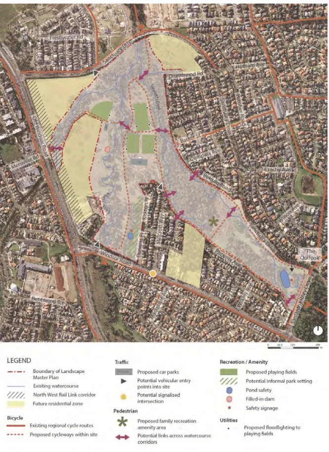
Explore opportunities to implement WSUD opportunities, including retrofitting existing development to the east and south of the city, and workshop opportunities with Urban Growth to incorporate WSUD into new residential development proposed west and northwest of the city. city. The height of the fields is set to a level just above the 2-year storm. The location of the access road for this development should be developed in conjunction with the design of the proposed adjacent future housing development.
Design, signage, artwork and naming of sports pavilions Provision of entrance signage on Millcroft Way. This will help create a link for all communities with the historical significance of the site. Other potential vehicular access points are proposed from Sanctuary Drive to the future residential development adjacent to the masterplan area to the north-west of the site and Windsor Street, both subject to future design.
The earthworks required to create the playing fields will cause localized increased flood velocities. It is expected that this will result in some areas of increased shedding along both Caddies Creek and Strangers Creek within the vicinity of the playing field blocks. It is proposed that the batsmen of the playing fields be protected from localized increases in velocity by the incorporation of patches of native grasses.
The future residential subdivisions to the west of the site are proposed to explore appropriate WSUD strategies as an integrated part of the subdivision design process. It is proposed to include a 'floating wetland' at the upstream end of 'The Outlook' pond to improve water quality. It is proposed that waste racks be installed at the upstream end of Caddies Creek; immediately downstream from 'The Outlook' pond; and to the upstream end of the unnamed tributary that enters the site from the west.
In addition, a pollution control device is proposed to be installed at the upstream end of the unnamed tributary to improve the quality of road runoff from Windsor Road.
Preliminary site contamination and salinity assessment for the proposed Caddies Creek Reserve playing fields at Windsor Road, Beaumont Hills, NSW. Final Report – Fire Protection and Hazard Reduction Zone Establishment Assessment for the Sydney Watershed Drainage Land. Flora and fauna surveys and ecological assessment for the eastern Caddies Creek Reserve and the site of the proposed Kellyville playing fields.
Environmental assessment for a proposed bicycle path link on Strangers Creek between Windsor Road and the Cattai Creek Recreational Area, Beaumont Hills.
Appendix A
Bushfire Risk Management
Sydney Water has commissioned a 'Bushfire Protection and Hazard Reduction Zone Creation Assessment' for all areas within the Rouse Hill Trunk Drainage Lands owned by Sydney Water.
Risk Areas
Hazard Reduction Zones
These include the plan in the heritage report showing the location of Aboriginal sites, photos of the site, east and north, location points and other location point descriptions.
Appendix B
Heritage Report
- Relevant Legislation
- Proposed Activity
- Data Sources
- Landscape Context
Due Diligence Assessment of trunk drainage land owned by SWC which the Hills Shire Council (Council) is proposing to partially develop into sports fields and associated infrastructure as part of the Caddies Creek Master Plan. This Code has been developed to assist advocates in exercising due diligence when carrying out activities that may harm Aboriginal objects. Defenses to a 'strict liability offence' include carrying out certain 'low impact activities' prescribed in clause 80B of the National Parks and Wildlife Amendments Regulations 2010 (NPW Regulations) and exercising due diligence.
An Aboriginal Heritage Impact Permit (AHIP) is required for Part 4 and 5 projects under the EP&A Act if impacts to Aboriginal properties and/or places cannot be avoided. The AHIP is a defense to prosecution for damage to Aboriginal objects and places where the damage has been authorized by the AHIP and the terms of that AHIP have not been breached. Council proposes to build four sports pitches and associated amenities, car parks, roads and pedestrian/cycle paths for blocks of land currently separately owned by SWC, Council and the Department of Planning and Infrastructure (DP&I) as part of the Caddies Creek Masterplan. 1.
Land surface disturbances that may occur as a result of development include major earthworks involving cut and fill activities to raise and level the land surface. An overview of the landscape context of the study area and surroundings that influences the modeling of the sites;. A summary of past Aboriginal archaeological research findings within the study area and surrounds;.
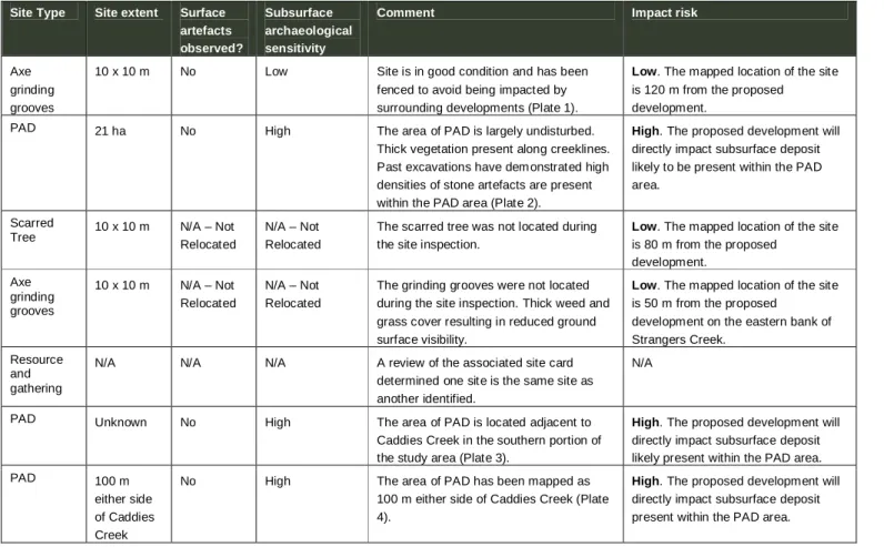
Topographically, the study area can be broadly characterized as flat and gently rolling, with elevations ranging from 38 – 46 m AHD (Australian Height Totum), rising to the northwest, adjacent to Windsor Road. The study area is dominated by the flood plain associated with Caddies and Strangers creeks, which are moderately cut and form a confluence in the northern part of the study area. Available geologic maps indicate that the surficial geology of the study area is dominated by Quaternary alluvium of fine sands, silts, and clays associated with Caddies and Strangers Creeks.
Plumpton Ridge, a geological feature associated with the St Marys Formation, is a well-known source of silcrete for the production of Aboriginal stone artefacts in western Sydney and is located approximately 5 km west of the study area.
PLAN
REMOVED
- AHIMS Database
- Additional Sites Not Registered with AHIMS
- Previous Archaeological Investigations
- Site Inspection
- Key Findings & Recommendations Key findings of this assessment are
- References
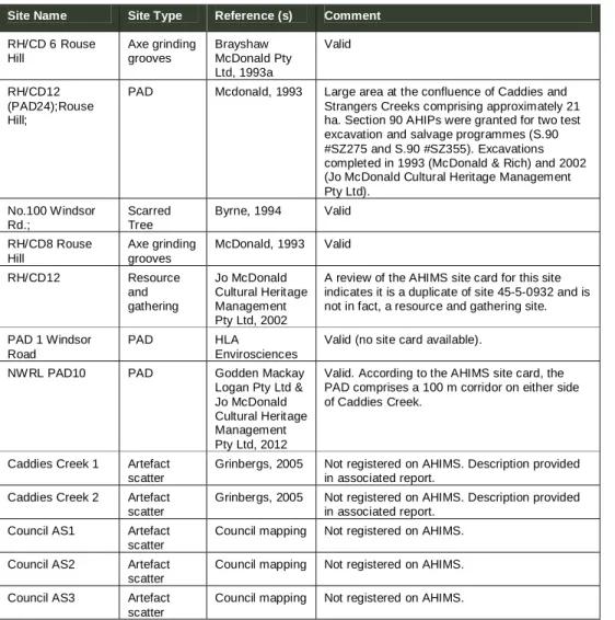
A review of the AHIMS database received by OEH on 6 September for a 5 x 5 km area centered on the study area indicated that seven Aboriginal sites are located within and directly adjacent to the study area. Maps provided to AECOM by Council (see Appendix B) have shown that there are six additional Aboriginal artefact sites within the study area that were not identified by the AHIMS search. In addition, a review of the locations of registered AHIMS sites within the map provided by the Council was undertaken.
Existing AHIMS data for the study area indicates that a number of archaeological investigations and/or excavations have been conducted in the study area and surrounding area over the past three decades. The results of all available studies conducted within and in close proximity to the current study area are summarized in Table 2 below. A total of 20 test wells were excavated along the alignment of a sewer line at 10 m intervals in the study area.
In addition, land within 50 m of Caddies Creek and the ridgeline west of Caddies Creek within the study area was identified as having underground archaeological sensitivity. A visual inspection of Aboriginal sites within the study area was undertaken by AECOM archaeologist Geordie Oakes on 16 September 2013. The purpose of the site inspection was to establish the location and condition of Aboriginal sites within the study area and to determine the risk of impact from proposed development.
A review of background reports and existing AHIMS data has identified 12 Aboriginal sites within the study area. Of these, five have been assigned a high risk of impact as they are within the impact zone of the proposed development. Two areas have been assigned a moderate risk of impact as they are within 20m of the proposed development.
Consideration of both the landscape context and previous archaeological investigations conducted within the study area suggest that soils within the study area have a high potential for underground archaeological deposits.
Community Newsletter
Caddies and Strangers Creek Landscape Master Plan
Melaleuca Forest near Caddies Creek and Strangers Creek that could be used for recreational purposes. Sydney Water owns land around Caddies and Strangers Creek which is within the 'one in hundred year' flood level. The plan will help preserve the area's ecological values, guide regeneration and recovery of endangered Coastal River-Flat Forest and.
You can participate by completing an online survey at www.sydneywatertalk.com.au under survey at www.sydneywatertalk.com.au under.
Caddies and Strangers Creek Landscape Master Plan’. Surveys close Friday 8 November
To learn more about the proposed sports complex please contact
To learn more about the landscape master plan please contact
You will have the opportunity to comment on the draft comprehensive landscape plan when it is later presented publicly.