Prepared by Crystelle Evangelista (Environment Officer) Gascoyne Region
March 2008
Printed copies are uncontrolled unless marked otherwise
PRELIMINARY ENVIRONMENTAL IMPACT ASSESSMENT AND ENVIRONMENTAL MANAGEMENT PLAN (MINOR PROJECTS)
MATERIAL PIT EXTENSIONS NORTH WEST COASTAL HIGHWAY
397.4 & 416.9 SLK
CONTENTS
1 INTRODUCTION ... 3
2 DESCRIPTION OF THE PROJECT ... 3
2.1 P
ROJECTL
OCATION... 3
3 METHODOLOGY ... 7
3.1 P
RELIMINARYD
ESKTOPS
TUDY... 7
4 COMMONWEALTH REFERRAL ... 8
4.1 S
ITEI
NVESTIGATION... 8
5 EXISTING ENVIRONMENT ... 8
5.1 D
ESCRIPTION... 8
5.2 S
ITEI
NVESTIGATION... 9
6 CLEARING OF NATIVE VEGETATION ... 10
6.1 A
SSESSMENT AGAINSTC
LEARINGP
RINCIPLES... 10
6.2 E
NVIRONMENTALLYS
ENSITIVEA
REA(ESA) ... 10
7 ASSESSMENT OF ASPECTS AND IMPACTS ... 11
8 DECISION TO REFER ... 12
9 STAKEHOLDER CONSULTATION ... 12
10 ENVIRONMENTAL MANAGEMENT PLAN ... 13
10.1 C
OMMUNICATIONP
LAN... 13
11 MONITORING ... 14
12 CONTINGENCY MEASURES ... 14
13 AUDITING ... 14
14 REFERENCES ... 14
APPENDIX A LOW IMPACT ENVIRONMENTAL SCREENING CHECKLIST ... 17
APPENDIX B MAIN ROADS WA – REVEGETATION PLAN FOR PASTORAL AREAS ... 19
APPENDIX C DEC’S THREATENED FLORA AND FAUNA DATABASE SEARCHES ... 22
APPENDIX D AUSTRALIAN HERITAGE PLACES INVENTORY, HERITAGE COUNCIL OF WESTERN AUSTRALIA AND THE MUNICIPAL HERITAGE INVENTORY DATABASE SEARCHES ... 24
APPENDIX E DEPARTMENT OF INDIGENOUS AFFAIRS DATABASE SEARCH ... 27
APPENDIX F WAPC’S ACID SULFATE SOILS MAPPING ... 30
APPENDIX G DEPARTMENT OF THE ENVIRONMENT AND HERITAGE DATABASE SEARCH ... 32
APPENDIX H SITE PHOTOS ... 37
APPENDIX I VEGETATION CLEARING ASSESSMENT REPORT ... 42
PRELIMINARY ENVIRONMENTAL IMPACT ASSESSMENT AND ENVIRONMENTAL MANAGEMENT PLAN (MINOR PROJECTS)
GRAVEL PIT EXTENSION (397.4 & 416.9 SLK)
1 INTRODUCTION
Main Roads Gascoyne and BGC over a number of years have slowly been exhausting gravel stockpiles within the Region. The extension of numerous pits is required to supply gravel for the maintenance of the Main Roads network and also for the supply of material in emergency situations (e.g. cyclone damage).
This report details the extension of 2 gravel pits located at:
• 397.4 SLK, LHS, North West Coastal Highway
• 416.9 SLK, LHS, north West Coastal Highway
All proposed pit extensions are within the Shire of Carnarvon.
As per Main Roads’ Environmental Assessment and Approval process, the Low Impact
Environmental Screening Checklist has been completed for the proposal, refer to Appendix A. As the proposed works involves the clearing of native vegetation, the preparation of a project specific Preliminary Environmental Impact Assessment (PEIA) and Environmental Management Plan (EMP) are required. This report fulfils this requirement.
2 DESCRIPTION OF THE PROJECT
Gravel Pit 397.4SLK is located approximately 200 meters off North West Coastal Highway on the left hand side. The proposed extension is to the west of the existing pit boundary (See Figure 2).
The dimensions of the pit are approximately 100m long by 100m wide. The access tracks into the pit are in good condition and will easily allow the movement of machinery in and out of the project area.
Gravel Pit 416.9SLK is located approximately 320 meters off North West Coastal Highway on the left hand side. The proposed extension is to the north west of the existing pit boundary (See figure 3). The dimensions of the pit are approximately 100m long by 100m wide. The access tracks into the pit are in good condition and will easily allow the movement of machinery in and out of the project area.
2.1 Project Location
The location and boundaries of the study area are shown in Figures 1-3.
Figure 1: Location of Proposed Pit Extensions on North West Coastal Highway SLK 397.4 and 416.9
Figure 1 – Project Location Map
Pit Extension 397.4
Pit Extension 416.9
Figure 2: Proposed Pit Extension on North West Coastal Highway SLK 397.4 A
C
D B
Pit Area Co-ordinates
A) 0205341 7179252 B) 0205414 7179325 C) 0205324 7179383 D) 0205254 7179316
Figure 3: Proposed Pit Extension on North West Coastal Highway SLK 416.9 A
B D
C
Pit Area Co-ordinates A) 0192834
7194060 B) 0192926 7194111 C) 0198276 7194229 D) 0192791 7134171
3 METHODOLOGY
3.1 Preliminary Desktop Study
A preliminary assessment of the project area and its potential constraints was undertaken by reviewing a number of government agency managed databases (and consulting where necessary).
3.1.1 Wetlands
The locations of wetlands within the project area was determined using the
Commonwealth Department of the Environmental and Heritage (DEH) mapping tool and Department of Environment and Conservation (DEC) Geographic Data Atlas mapping tool (http://apostle.environment.wa.gov.au/idelve/doedataext/index.jsp).
3.1.2 Threatened Flora, Fauna and Communities, Conservation Reserves and ESAs DEC’s database was searched for known populations of threatened flora, fauna and Threatened Ecological Communities (TECs) and conservation reserves, refer to Appendix C.
3.1.3 Air Quality
The need for a local air quality assessment was determined using the criteria outlined in the MRWA environmental guideline, Air Quality.
3.1.4 Heritage
Non-indigenous heritage was examined utilising the Australian Heritage Places Inventory (http://www.heritage.gov.au), Heritage Council of Western Australia
(http://register.heritage.wa.gov.au/) and the Shire’s of Carnarvon and Ashburton Municipal Heritage Inventory, refer to Appendix D.
3.1.5 Aboriginal Heritage
A Search of the Department of Indigenous Affairs’ (DIA’s)
(http://www.dia.wa.gov.au/Heritage/SitesSurveysSearch.aspx) database was undertaken to determine whether the project area contains any sites of Aboriginal heritage, refer to Appendix E.
3.1.6 Sensitive Water Resources
The Commonwealth Department of the Environmental and Heritage (DEH) mapping tool and Department of Environment and Conservation (DEC) Geographic Data Atlas mapping tool was used to determine whether the project area supported, or was adjacent to, any significant lakes, rivers or wetlands or proclaimed areas.
3.1.7 Contaminated Sites
The reserve has been in Main Roads continual control; therefore no further work will be necessary/required.
3.1.8 Acid Sulfate Soils
The Western Australian Planning Commission’s (WAPC’c) acid sulfate soils maps were reviewed and the self assessment done
(http://www.wapc.wa.gov.au/Publications/213.aspx) to determine what level of risk the project area is exposed to, refer to Appendix F.
3.1.9 Weeds
An onsite investigation of the project areas was undertaken to determine whether there
are any known populations of declared plants or significant weeds in or adjacent to the
project area.
3.1.10 Dieback
Project receives <400 mm of rain so determined not to be an issue.
4 COMMONWEALTH REFERRAL
The decision whether to refer the project to the Commonwealth’s DEH was based upon whether the project would impact upon matters of national significance, e.g. World Heritage properties, protected wetlands and migratory species, Commonwealth marine areas, threatened species or communities or nuclear actions (refer to the Commonwealth webpage www.deh.gov.au/epbc/assessmentsapprovals/index.html for further information and the search tool page at http://www.deh.gov.au/erin/ert/epbc/imap/map.html), refer to Appendix G.
4.1 Site Investigation
A site visit was carried out by Robbie Mallard (BGC Contractor) and Crystelle Evangelista (Environment Officer) on 13/03/08 to examine the general features of the area. The broad vegetation types in the vicinity of the project area were identified. Other issues that were considered included topography, the impacts on creek lines, property access and the potential for noise and vibration impacts (dilapidation).
Site photos were taken and are included in Appendix H.
5 EXISTING ENVIRONMENT 5.1 Description
Pit 379.4 SLK
This material pit occurs within vegetation association No. 346 which is described as Mosaic: “Shrublands; Acacia sclerosperma, A. victoriae & snakewood scrub / Shrublands;
patches of low mixed scrub”. According to Native Vegetation Association Data (DEC &
DAF) this vegetation association is well represented in the region with 100% remaining.
The condition of the vegetation is best described as degraded due to the grazing of cattle and previous material extraction.
Pit 416.9 SLK
This material pit occurs within vegetation association No. 346 which is described as Mosaic: “Shrublands; Acacia sclerosperma, A. victoriae & snakewood scrub / Shrublands;
patches of low mixed scrub”. According to Native Vegetation Association Data (DEC &
DAF) this vegetation association is well represented in the region with 100% remaining.
The condition of the vegetation is best described as degraded due to the grazing of cattle and previous material extraction.
The following lists of species were observed at the proposed material pits:
Acacia sclerosperma Acacia tetragonopylla Hakea preissii
Stylobasium spathulatum Scaevola spinescens Acacia eremaea No mature trees will be cleared for the works.
There are no declared rare or priority flora within the pit sites.
5.2 Site Investigation
Site Investigation Description/Comment
Total area (ha) of native vegetation to be cleared
379.4 SLK = 1 (ha) 416.9 SLK = 1 (ha) Total area (ha) of other vegetation,
including regrowth, landscape areas, to be cleared
0
Weeds present Cenchrus ciliaris (Buffel Grass) Drainage areas or wetlands present None
Adjacent land uses Pastoral
6 CLEARING OF NATIVE VEGETATION
Native vegetation describes all indigenous aquatic and terrestrial vegetation (living or dead). The term does not include vegetation that was intentionally sown, planted or propagated unless it was required under a statutory condition.
Apart from activities that are exempt under the clearing regulations, such as clearing vegetation that is less than 10 years old for maintenance, typically all Main Roads clearing will be undertaken using its Statewide Project Purpose Permit.
6.1 Assessment against Clearing Principles
In assessing whether the project is likely to have a significant impact on the environment, the project has been assessed against the DEC’s 10 principles of clearing, refer to Appendix I.
The project will not be at variance with the DEC’s 10 clearing principles.
6.2 Environmentally Sensitive Area (ESA)
Clearing within an Environmentally Sensitive Area (ESA)
Yes/
No
Comments Does the area to be cleared occur within
an ESA where the vegetation is in good or better condition?
No
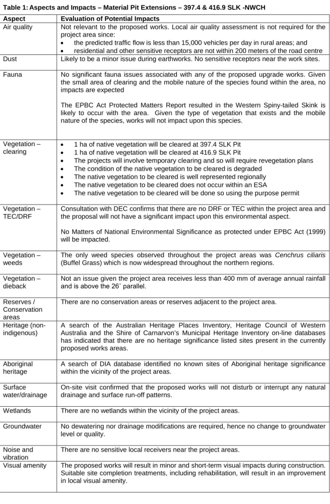
7 ASSESSMENT OF ASPECTS AND IMPACTS
Table 1: Aspects and Impacts – Material Pit Extensions – 397.4 & 416.9 SLK -NWCH Aspect Evaluation of Potential Impacts
Air quality Not relevant to the proposed works. Local air quality assessment is not required for the project area since:
• the predicted traffic flow is less than 15,000 vehicles per day in rural areas; and
• residential and other sensitive receptors are not within 200 meters of the road centre Dust Likely to be a minor issue during earthworks. No sensitive receptors near the work sites.
Fauna No significant fauna issues associated with any of the proposed upgrade works. Given the small area of clearing and the mobile nature of the species found within the area, no impacts are expected
The EPBC Act Protected Matters Report resulted in the Western Spiny-tailed Skink is likely to occur with the area. Given the type of vegetation that exists and the mobile nature of the species, works will not impact upon this species.
Vegetation – clearing
• 1 ha of native vegetation will be cleared at 397.4 SLK Pit
• 1 ha of native vegetation will be cleared at 416.9 SLK Pit
• The projects will involve temporary clearing and so will require revegetation plans
• The condition of the native vegetation to be cleared is degraded
• The native vegetation to be cleared is well represented regionally
• The native vegetation to be cleared does not occur within an ESA
• The native vegetation to be cleared will be done so using the purpose permit Vegetation –
TEC/DRF
Consultation with DEC confirms that there are no DRF or TEC within the project area and the proposal will not have a significant impact upon this environmental aspect.
No Matters of National Environmental Significance as protected under EPBC Act (1999) will be impacted.
Vegetation – weeds
The only weed species observed throughout the project areas was Cenchrus ciliaris (Buffel Grass) which is now widespread throughout the northern regions.
Vegetation – dieback
Not an issue given the project area receives less than 400 mm of average annual rainfall and is above the 26˚ parallel.
Reserves / Conservation areas
There are no conservation areas or reserves adjacent to the project area.
Heritage (non- indigenous)
A search of the Australian Heritage Places Inventory, Heritage Council of Western Australia and the Shire of Carnarvon’s Municipal Heritage Inventory on-line databases has indicated that there are no heritage significance listed sites present in the currently proposed works areas.
Aboriginal heritage
A search of DIA database identified no known sites of Aboriginal heritage significance within the vicinity of the project areas.
Surface water/drainage
On-site visit confirmed that the proposed works will not disturb or interrupt any natural drainage and surface run-off patterns.
Wetlands There are no wetlands within the vicinity of the project areas.
Groundwater No dewatering nor drainage modifications are required, hence no change to groundwater level or quality.
Noise and vibration
There are no sensitive local receivers near the project areas.
Visual amenity The proposed works will result in minor and short-term visual impacts during construction.
Suitable site completion treatments, including rehabilitation, will result in an improvement in local visual amenity.
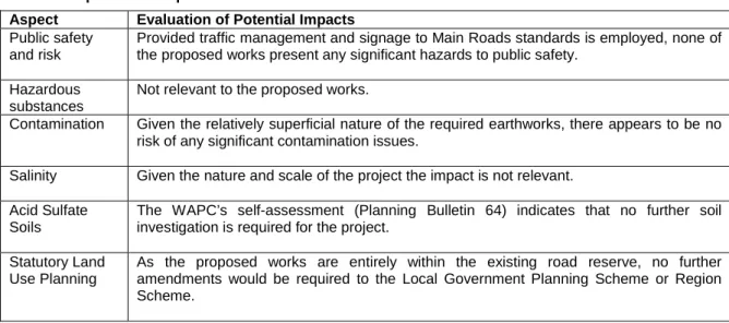
Table 1: Aspects and Impacts – Material Pit Extensions – 397.4 & 416.9 SLK -NWCH Aspect Evaluation of Potential Impacts
Public safety and risk
Provided traffic management and signage to Main Roads standards is employed, none of the proposed works present any significant hazards to public safety.
Hazardous substances
Not relevant to the proposed works.
Contamination Given the relatively superficial nature of the required earthworks, there appears to be no risk of any significant contamination issues.
Salinity Given the nature and scale of the project the impact is not relevant.
Acid Sulfate Soils
The WAPC’s self-assessment (Planning Bulletin 64) indicates that no further soil investigation is required for the project.
Statutory Land Use Planning
As the proposed works are entirely within the existing road reserve, no further amendments would be required to the Local Government Planning Scheme or Region Scheme.
8 DECISION TO REFER
Given the scale of the project, the low significance of its impacts to the surrounding environment and the environmental management measures proposed, the project does not require referral to the WA Environmental Protection Authority or the Commonwealth Department of the Environment and Heritage.
9 STAKEHOLDER CONSULTATION
Name Agency Date Comments
Bridgette Long (Flora) DEC Kellie Mantle (Fauna) DEC
10 ENVIRONMENTAL MANAGEMENT PLAN
This section of the report (the EMP) has been developed for the project area following the completion of the above sections. The main aim of this EMP is to provide a management plan to assist in minimising the environmental impacts of the activities associated with the proposed works and identify who is responsible for the implementation of the
management strategies.
This EMP will only address the actions already listed as well as any site-specific issues that were identified during the PEIA. The project specific management measures
identified within this EMP are in addition to the standard specifications used for Category 2 projects. The environmental management measures/conditions in Main Road’s
Specifications 203, 204, 301, 302 and 304 are still to be followed where applicable.
The areas that require special management will be addressed in terms of:
• the timing of the various management actions;
• the topic (e.g. vegetation);
• the objectives for each area;
• the actions that are necessary to minimise the impact;
• the responsible party for implementing the action; and
• whether the action arose from external advice or is a Main Roads requirement.
10.1 Communication Plan
Environmental issues specific to the project will be communicated as:
Method Frequency Participants Reference Record Project Site
Induction Prior to Work All personnel and subcontractors
EMP and Contractor Environmental Policy
Induction Meeting
Authority Consultation Department of Environment and Conservation
As required Main Roads’
Project Manager and Contractor Project Manager
- Minutes of meeting
10.1.1 External Communication and Complaints
A complaints register shall be maintained by the contractor. All complaints received shall
be forwarded to the Main Roads’ Project Manager for action. Serious complaints shall be
investigated within 24 hours of the complaint being received.
11 MONITORING
After project completion, revegetated areas will be inspected every six months for the first two years to ensure weed spread or establishment has not occurred and to measure the effectiveness of revegetation works.
Monitoring of the weeds identified in the project area will comprise the use of input criteria listed below.
Criterion Target After three
months
After one year
After three years Mean weed foliage cover (%). <20 <20 <20 <20
12 CONTINGENCY MEASURES
Given the scale and nature of the project, no contingency measures are identified as the inherent environmental risks are small.
13 AUDITING
Given the scale and nature of the project, there is no requirement for auditing the implementation of the EMP as the environmental risks are small.
14 REFERENCES
Mitchell, A. A. and Wilcox, D. G. (1994) Arid Shrubland Plants of Western Australia,
Second and Enlarged Edition. University of Western Australia Press, Nedlands, Western
Australia. ISBN 1-874460-22-X.
ENVIRONMENTAL MANAGEMENT PLAN
Timing Topic Objective Action Responsible Party Advice
All phases of Construction
Vegetation Clearing - Record-keeping
All projects should maintain the required records relating to clearing native vegetation under the purpose permit.
Clearing:
• a copy of the PEIA & EMP (Minor projects) for small projects;
• a map showing the location where the clearing occurred, recorded in an ESRI Shapefile;
• the size of the area cleared (in hectares); and
• the dates on which the clearing was done.
Project Manager DEC
Revegetation and rehabilitation of areas:
• a copy of each Revegetation Plan;
• a map showing the location of any area revegetated and rehabilitated recorded in an ESRI Shapefile;
• a description of the revegetation and rehabilitation activities undertaken; and
• the size of the area revegetated and rehabilitated (in hectares).
Project Manager DEC
Pre-Construction Vegetation - Clearing
Ensure that the overall objectives of the alignment and construction works are compatible with maintaining and, where possible, enhancing the biological integrity of the surrounding environment and minimising
vegetation loss and degradation; and Ensure the retention of as many habitat trees, shrubs and vegetated corridors for fauna as possible, particularly where associated with riparian zones.
Selection of designs/locations that minimise adverse impacts on the biological environment.
Project Manager Main Roads Construction works to be undertaken in summer to reduce the
potential for soil erosion and drainage line siltation due to vegetation removal and heavy rains.
Project Manager Main Roads
Control/spray weeds species within the project area prior to construction to limit the amount of propagative material that may be spread during disturbance.
Contractor Main Roads
Any stockpiled vegetation from clearing works shall not be burnt. This vegetation shall be used during any rehabilitation works and either chipped or replaced according to the EMP.
Contractor Main Roads
Construction Noise, Vibration and Dust
Ensure that the construction of the proposal does not become a nuisance to the public.
Access to private property and appropriate traffic management measures should be planned and implemented prior to the construction of works.
Contractor Main Roads
Works associated with the construction of the development should not prevent public access along the adjacent reserve.
Public access should be maintained along the reserve at all times.
Contractor Main Roads
Any complaints regarding dust will be attended to as soon as possible.
Contractor/Project Manager
Main Roads Where it is found that trucks leaving the site are carrying
excessive material onto sealed surfaces, these areas will be swept to reduce dust generation and maintain traffic safety.
Contractor Main Roads
ENVIRONMENTAL MANAGEMENT PLAN
Timing Topic Objective Action Responsible Party Advice
Construction Pollution and Litter
Ensure that the construction of the proposal is managed to a standard that minimises any adverse impacts on the environment.
The designated servicing area will be bunded to contain any spills or leaks and shall not be located in an area adjacent to any drainage areas or watercourses or will drain into a temporary sump.
Contractor Main Roads
Emergency cleanup procedures shall be implemented in the case of any spillage. These will include control of spilled material and removal of contaminated soil to an approved site.
The contractor shall ensure appropriate equipment is available at all times and shall notify the Superintendent’s
Representative of a spill.
Contractor Main Roads
All waste oil will be collected for recycling and any empty fuel/oil containers, used filters and waste hydraulic parts to be collected and stored in an allocated area then removed to an approved site.
Contractor Main Roads
Dumping or temporary storage of bitumen, asphalt, concrete or aggregate should only occur at designated depots or controlled hardstands.
Contractor Main Roads
The project areas, including hardstand areas, will be kept in a tidy manner at all times.
Contractor Main Roads
Construction Fire Ensure that the fire risk associated with the construction of the proposal is minimised.
No fires shall be lit within the project area. Contractor Main Roads
Construction Site
Management
Ensure that the site is managed to ensure that construction of the proposal will have minimal impact upon the surrounding environment.
Materials storage areas will be located on previously disturbed/
designated area.
Contractor Main Roads
Post-Construction Rehabilitation Leave the project area free from debris; and
Rehabilitate the project area so that the revegetated area provides a net increase in area of native vegetation at the site.
Replace the cleared trees with locally occurring natives. Contractor Main Roads All waste materials from the development are to be completely
removed from the site upon completion of the development.
Final clean-up shall be to the satisfaction of the Project Manager and the Site Superintendent.
Contractor Main Roads
Appendix A
Low Impact Environmental Screening Checklist
Appendix B
Main Roads WA – Revegetation Plan for Pastoral Areas
Main Roads WA – Revegetation Plan for Pastoral Areas Condition 14(e), CPS 818
Date: Unknown. Project: Unknown.
Manager: Main Roads WA.
Location and size of clearing:
For project areas located within the pastoral / rangelands region north of the agricultural area as described in the Environmental Protection Authority’s Position Statement No.2.
Location and size of revegetation:
Primarily for areas that were cleared for searching and extracting road building materials (e.g. borrow pits, etc.), and other project related temporary clearing.
Clearing description: Machine clearing.
Revegetation description:
Replacement of topsoil material regeneration.
Reason for revegetation:
Revegetation of temporary cleared areas, in accordance with condition 14 of clearing permit CPS 818.
Revegetation / rehabilitation requirements:
Site preparation:
All vegetation will be cleared from the works area and non-weed infested vegetation is stockpiled. Stockpiled vegetation will be placed in a manner that will prevent damage to adjacent vegetation by machinery. Weed infested vegetation will be disposed of at an appropriate site and not used for
revegetation purposes. Burning of the cleared vegetation will not be permitted.
Topsoil will be stripped to a maximum depth of 100mm, and will be stored in a weed free (as far as possible) area, as close as possible to the area to be rehabilitated. Topsoil will be placed in windrows of less than 1.5m in height and reinstated as soon as practicable to maintain viability of in-situ seeds.
Weed control:
Appropriate weed control will be carried out when weeds are present, both prior to topsoil stripping and where weeds become established on or between the stockpiled materials. Weed control will take place prior to the respreading of topsoil to ensure weeds are killed and not transported to other areas.
Control measures include the removal of weeds to an approved dumpsite, or treatment of weeds such as by using herbicides mixed in accordance with manufacturer’s instructions and applied by a licensed operator. Where
practicable, weeds will be removed prior to or when they are in flower, and prior to seeding.
All machinery will be cleared of soil build up and vegetative material before entering and leaving the site to help minimise the transportation of weeds and their seeds.
Exposed areas such as bare batters and borrow pits shall be promptly
rehabilitated to reduce the potential for weed establishment. Where works are
adjacent to good quality vegetation, where weeds from within the project area
Main Roads WA – Revegetation Plan for Pastoral Areas Condition 14(e), CPS 818
Regeneration / direct seeding / planting at an optimal time:
The following rehabilitation works are undertaken on areas of disturbed earth requiring rehabilitation:
•
Topsoil is uniformly respread to a typical depth of 100mm over the project area. In project areas where topsoil has not been removed and/or is not available, other substrate, such as gravel, may be substituted as a growth medium.
•
Project areas will be ripped to a minimum depth of 200mm deep with rip lines approximately 300mm apart. Where slopes are present, rip lines shall follow natural contours.
The following rehabilitation works are undertaken at borrow / gravel pits:
•
Overburden and then topsoil will be uniformly and evenly spread over the disturbed areas of the pit. Depending on the slope of drainage lines within the pit, small swales from the topsoil will be formed to reduce erosion velocities and encourage the deposition of seeds.
•
The whole of the existing pit floor, including drainage lines, will be ripped to a depth of 300-500mm deep with rip lines between 500-800mm apart (if the material in the pit is able to be ripped).
•
All stockpiled vegetation will be spread along the contour and the pit floor to help promote seed deposition and to reduce erosion velocities.
Vegetation
establishment period:
The vegetation establishment period is for at least twelve months following the completion of the works. During this period, maintenance and monitoring will be undertaken (see below).
Ongoing maintenance and monitoring:
After revegetation works, revegetated areas will be inspected annually for a minimum of two years to monitor and control weeds and to measure the effectiveness of revegetation works.
When unwanted weed foliage cover exceeds 25% after the initial two year period, further actions will be implemented to monitor and control these weeds.
The additional monitoring and weed control will be conducted annually until 12 Dec 2010 or until the unwanted weed foliage cover falls below 25%, whichever is sooner.
Monitoring commitments:
Post revegetation site inspections will be carried out annually for a minimum of two years to monitor unwanted weeds and measure the effectiveness of revegetation works. Monitoring of sites where unwanted weed foliage cover exceeds 25% after the initial two year period will continue annually until 12 Dec 2010 or until the unwanted weed foliage cover falls below 25%, whichever is sooner.
Management commitments:
Undertake annual weed control of unwanted weeds annually until 12 Dec 2010 or until the unwanted weed foliage cover falls below 25%, whichever is sooner.
Agencies consulted and submissions received:
Nil.
Main Roads Western Australia Page 21 of 48
Appendix C
DEC’s Threatened Flora and Fauna Database Searches
Appendix D
Australian Heritage Places Inventory, Heritage Council of Western Australia and the Municipal Heritage Inventory
Database Searches
Appendix E
Department of Indigenous Affairs Database Search
Main Roads Western Australia Page 29 of 48
Appendix F
WAPC’s Acid Sulfate Soils Mapping
Appendix G
Department of the Environment and Heritage Database
Search
Appendix H
Site Photos
Photograph 1: Pit Extension 397.4 SLK – North West Coastal Highway – North View
Photograph 2: Pit Extension 397.4 SLK – North West Coastal Highway – South East View
Photograph 3: Pit Extension 397.4 SLK – North West Coastal Highway – West View
Photograph 4: Pit Extension 397.4 SLK – North West Coastal Highway – Dumped Rubbish
Main Roads Western Australia Page 39 of 48
Photograph 5: Pit Extension 416.9 SLK – North West Coastal Highway – North View
Photograph 7: Pit Extension 416.9 SLK – North West Coastal Highway –East View
Main Roads Western Australia Page 41 of 48
Appendix I
Vegetation Clearing Assessment Report
MRWA Vegetation Clearing Assessment Report
This report has been prepared to assist MRWA in addressing condition 7 “Assessment of Clearing Impacts” under Clearing Permit CPS 818/3.
For guidance on how to complete the form, refer to DEC completed reports (active permits) at
http://203.20.251.100/cps_reports/.AREA UNDER ASSESSMENT DETAILS Proponent details
Proponent’s name: MRWA Gascoyne Region
Contacts: Name: Crystelle Evangelista
Phone: (08) 9941 0713 Fax: (08) 9941 0701
Email: [email protected]
Property details
Property: Pit Extension – North West Coastal Highway – SLK 397.4 Colloquial name:
Area under assessment
Clearing Area (ha) No. Trees Method of Clearing For the purpose of: Site Plan Attached 0.01 0 Mechanical Road Building
Materials
Yes No
Avoidance/Minimise clearing
How have the clearing impacts been minimised?
Areas for extension have been carefully selected based upon preliminary material investigation.
BACKGROUND
This material pit occurs within vegetation association 346 which is described as Mosaic: “Shrublands; Acacia sclerosperma, A. victoriae &
snakewood scrub / Shrublands; patches of low mixed scrub” (DEC & DAF) this vegetation association is well represented in the region with 100% remaining. The condition of the vegetation is best described as degraded due to the grazing of cattle and previous material extraction.
Site Visit Undertaken Yes No
Fauna / Flora Survey Undertaken Yes No Site Report Attached Yes No
Fauna / Flora Survey Report Attached Yes No Site Photos Attached Yes No
Other Relevant References Attached Yes No
Vegetation Association Clearing Description Vegetation Condition Comment 346
Mechanical Degraded
ASSESSMENT OF APPLICATION AGAINST CLEARING PRINCIPLES
(a) Native vegetation should not be cleared if it comprises a high level of biological diversity.
Comments Proposal is not at variance to this Principle
The area under application predominantly consists of grasses and a few scattered shrubs. The condition of the vegetation is somewhat degraded and does not represent a high level of biodiversity. This proposal is therefore not at variance with this Principle.
Methodology Site visit (13/03/08) GIS Databases:
- Interim Biogeographic Regionalisation of Australia – 13/03/08.
(b) Native vegetation should not be cleared if it comprises the whole or a part of, or is necessary for the maintenance of, a significant habitat for fauna indigenous to Western Australia.
Comments Proposal is not at variance to this Principle
The area under application predominantly consists of grasses and a few scattered shrubs. The condition of the vegetation is somewhat degraded and does not represent a significant habitat for fauna. Due to the relatively small clearing area
necessary for the pit extensions, impact to fauna species will be marginal. This proposal is therefore not at variance with this Principle.
Methodology Site visit (13/03/08) DEC advice –
Main Roads Western Australia Page 43 of 48
(c) Native vegetation should not be cleared if it includes, or is necessary for the continued existence of, rare flora.
Comments Proposal is not likely to be at variance to this Principle
DEC Threatened Flora Database search was conducted and no rare flora was known to exist within the project areas. Also based upon site visit s, no rare flora species were identified. It is therefore unlikely that the vegetation under application is necessary for significant flora. This proposal is therefore not at variance with this Principle.
Methodology Site visit (13/03/08) GIS Databases:
- Declared Rare and Priority Flora list – DEC
(d) Native vegetation should not be cleared if it comprises the whole or a part of, or is necessary for the maintenance of a threatened ecological community.
Comments Proposal is not at variance to this Principle
There are no records of Threatened Ecological Communities (TEC’S) for the area under application. This proposal is therefore not at variance with this Principle.
Methodology GIS Databases:
- Threatened Ecological Communities – DEC 17/03/08
(e) Native vegetation should not be cleared if it is significant as a remnant of native vegetation in an area that has been extensively cleared.
Comments Proposal is not at variance to this Principle
Pit 397.4 SLK is representative of Beard Vegetation Association 346 of which 100% % of the pre-European extent remains.
This vegetation association is therefore of ‘least concern’ for biodiversity conservation.
This proposal is therefore not at variance with this Principle.
Methodology GIS Databases:
- Interim Biogeographic Reginalisation of Australia – 17/03/08 - Pre-European Vegetaion
(f) Native vegetation should not be cleared if it is growing in, or in association with, an environment associated with a watercourse or wetland.
Comments Proposal is not at variance to this Principle
The area under application does not consist of a watercourse or wetland . This proposal is therefore not at variance with this Principle.
Methodology Site visit (13/03/08)
DEC’s web based Geographic Data Atlas mapping tool GIS Databaes:
- Hydrography, linear
- Hydrographic Catchments – Catchments
(g) Native vegetation should not be cleared if the clearing of the vegetation is likely to cause appreciable land degradation.
Comments Proposal is not at variance to this Principle
The area under application consists of texture contrast soils. Given the small clearing footprint and that the vegetation consists mainly of grasses and a few scattered shrubs (with 100% of pre-European vegetation remaining). The proposal is not at variance with this principle.
Methodology Site visit (13/03/08) GIS Databases:
- Acid Sulphate Soil risk map
(h) Native vegetation should not be cleared if the clearing of the vegetation is likely to have an impact on the environmental values of any adjacent or nearby conservation area.
Comments Proposal is not at variance to this Principle
The proposed project is not near any conservation areas and therefore is not at variance with this Principle.
Methodology Site Visit (13/03/08)
(i) Native vegetation should not be cleared if the clearing of the vegetation is likely to cause deterioration in the quality of surface or underground water.
Comments Proposal is not at variance to this Principle
The area under application only receives approximately 300mm of annual rainfall. Due to the low rainfall rate, these proposals will not cause deterioration in the quality of surface or under ground water and therefore not a variance to this Principle.
Methodology Site Visit (13/03/08)
DEC’s web based Geographic Data Atlas mapping tool Rainfall, Mean Annual – BOM 17/03/08
(j) Native vegetation should not be cleared if clearing the vegetation is likely to cause, or exacerbate, the incidence or intensity of flooding.
Comments Proposal is not at variance to this Principle
The soil consists of textured contrast soils. In addition the area under application only receives approximately 300mm of annual rainfall. Due to the nature of the soil and the low rainfall rate, these proposals will not exacerbate the incidence of flooding and therefore is not at variance with this Principle.
Methodology Site Visit (13/03/08)
Rainfall, Mean Annual – BOM 17/03/08
Planning instrument, Native Title, RIWI Act Licence, EP Act Licence, Works Approval, Previous EPA decision or other matter.
Comments
There is no further requirement for a RIWI Act Licence, Works Approval or EP Act Licence for the area under application.
Methodology
SUBMISSIONS
If required have submissions been requested and addressed
Submission Requested from Request Sent (Date) Submission Received (Date)
Issues Raised / Comments Made
ASSESSOR’S RECOMMENDATIONS
OFFICER PREPARING REPORT
Crystelle Evangelista (Graduate Environment Officer) Gascoyne Regional Office MRWA
Phone 08 9941 0713 Date 26/03/08
Main Roads Western Australia Page 45 of 48
MRWA Vegetation Clearing Assessment Report
This report has been prepared to assist MRWA in addressing condition 7 “Assessment of Clearing Impacts” under Clearing Permit CPS 818/3.
For guidance on how to complete the form, refer to DEC completed reports (active permits) at
http://203.20.251.100/cps_reports/.AREA UNDER ASSESSMENT DETAILS Proponent details
Proponent’s name: MRWA Gascoyne Region
Contacts: Name: Crystelle Evangelista
Phone: (08) 9941 0713 Fax: (08) 9941 0701
Email: [email protected]
Property details
Property: Pit Extension – North West Coastal Highway – SLK 416.9 Colloquial name:
Area under assessment
Clearing Area (ha) No. Trees Method of Clearing For the purpose of: Site Plan Attached 0.01 0 Mechanical Road Building
Materials
Yes No
Avoidance/Minimise clearing
How have the clearing impacts been minimised?
Areas for extension have been carefully selected based upon preliminary material investigation.
BACKGROUND
This material pit occurs within vegetation association 346 which is described as Mosaic: “Shrublands; Acacia sclerosperma, A. victoriae &
snakewood scrub / Shrublands; patches of low mixed scrub” (DEC & DAF) this vegetation association is well represented in the region with 100% remaining. The condition of the vegetation is best described as degraded due to the grazing of cattle and previous material extraction.
Site Visit Undertaken Yes No
Fauna / Flora Survey Undertaken Yes No Site Report Attached Yes No
Fauna / Flora Survey Report Attached Yes No Site Photos Attached Yes No
Other Relevant References Attached Yes No
Vegetation Complex Clearing Description Vegetation Condition Comment
346
Mechanical Degraded
ASSESSMENT OF APPLICATION AGAINST CLEARING PRINCIPLES
(a) Native vegetation should not be cleared if it comprises a high level of biological diversity.
Comments Proposal is not at variance to this Principle
The area under application predominantly consists of grasses and a few scattered shrubs. The condition of the vegetation is somewhat degraded and does not represent a high level of biodiversity. This proposal is therefore not at variance with this Principle.
Methodology Site visit (13/03/08) GIS Databases:
- Interim Biogeographic Regionalisation of Australia – 13/03/08.
(c) Native vegetation should not be cleared if it comprises the whole or a part of, or is necessary for
the maintenance of, a significant habitat for fauna indigenous to Western Australia.
DEC advice –
(c) Native vegetation should not be cleared if it includes, or is necessary for the continued existence of, rare flora.
Comments Proposal is not likely to be at variance to this Principle
DEC Threatened Flora Database search was conducted and no rare flora was known to exist within the project areas. Also based upon site visit s, no rare flora species were identified. It is therefore unlikely that the vegetation under application is necessary for significant flora. This proposal is therefore not at variance with this Principle.
Methodology Site visit (13/03/08) GIS Databases:
- Declared Rare and Priority Flora list – DEC
(d) Native vegetation should not be cleared if it comprises the whole or a part of, or is necessary for the maintenance of a threatened ecological community.
Comments Proposal is not at variance to this Principle
There are no records of Threatened Ecological Communities (TEC’S) for the area under application. This proposal is therefore not at variance with this Principle.
Methodology GIS Databases:
- Threatened Ecological Communities – DEC 17/03/08
(e) Native vegetation should not be cleared if it is significant as a remnant of native vegetation in an area that has been extensively cleared.
Comments Proposal is not at variance to this Principle
Pit 416.9 SLK is representative of Beard Vegetation Association 346 of which 100% % of the pre-European extent remains.
This vegetation association is therefore of ‘least concern’ for biodiversity conservation.
This proposal is therefore not at variance with this Principle.
Methodology GIS Databases:
- Interim Biogeographic Reginalisation of Australia – 17/03/08 - Pre-European Vegetaion
(f) Native vegetation should not be cleared if it is growing in, or in association with, an environment associated with a watercourse or wetland.
Comments Proposal is not at variance to this Principle
The area under application does not consist of a watercourse or wetland . This proposal is therefore not at variance with this Principle.
Methodology Site visit (13/03/08)
DEC’s web based Geographic Data Atlas mapping tool GIS Databaes:
- Hydrography, linear
- Hydrographic Catchments – Catchments
(g) Native vegetation should not be cleared if the clearing of the vegetation is likely to cause appreciable land degradation.
Comments Proposal is not at variance to this Principle
The area under application consists of texture contrast soils. Given the small clearing footprint and that the vegetation consists mainly of grasses and a few scattered shrubs (with 100% of pre-European vegetation remaining). The proposal is not at variance with this principle.
Methodology Site visit (13/03/08) GIS Databases:
- Acid Sulphate Soil risk map
(h) Native vegetation should not be cleared if the clearing of the vegetation is likely to have an impact on the environmental values of any adjacent or nearby conservation area.
Comments Proposal is not at variance to this Principle
The proposed project is not near any conservation areas and therefore is not at variance with this Principle.
Methodology Site Visit (13/03/08)
DEC’s web based Geographic Data Atlas mapping tool
Main Roads Western Australia Page 47 of 48
(i) Native vegetation should not be cleared if the clearing of the vegetation is likely to cause deterioration in the quality of surface or underground water.
Comments Proposal is not at variance to this Principle
The area under application only receives approximately 300mm of annual rainfall. Due to the low rainfall rate, these proposals will not cause deterioration in the quality of surface or under ground water and therefore not a variance to this Principle.
Methodology Site Visit (13/03/08)
DEC’s web based Geographic Data Atlas mapping tool Rainfall, Mean Annual – BOM 17/03/08
(j) Native vegetation should not be cleared if clearing the vegetation is likely to cause, or exacerbate, the incidence or intensity of flooding.
Comments Proposal is not at variance to this Principle
The soil consists of textured contrast soils. In addition the area under application only receives approximately 300mm of annual rainfall. Due to the nature of the soil and the low rainfall rate, these proposals will not exacerbate the incidence of flooding and therefore is not at variance with this Principle.
Methodology Site Visit (13/03/08)
Rainfall, Mean Annual – BOM 17/03/08
Planning instrument, Native Title, RIWI Act Licence, EP Act Licence, Works Approval, Previous EPA decision or other matter.
Comments
There is no further requirement for a RIWI Act Licence, Works Approval or EP Act Licence for the area under application.
Methodology
SUBMISSIONS
If required have submissions been requested and addressed
Submission Requested from Request Sent (Date) Submission Received (Date)
Issues Raised / Comments Made