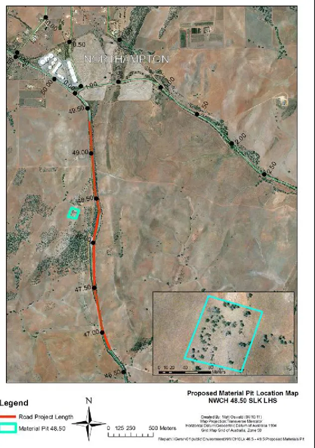
The North West Coastal Highway (NWCH) is the main link connecting the Brand Highway (Geraldton) with the Great Northern Highway (Port Hedland). On the section between 45.56 and 48.56 SLK, six accidents have been reported over the past five years, all involving loss of control. Main Roads Western Australia (Main Roads) proposes to reconstruct two sections of the highway between SLK 47.0 and 49.0 (the Project), which will involve lowering vertical crests to increase the line of sight for vehicles, increase road safety and reduce the risk of road accidents.
This project identified the material source at SLK 48.5, which is adjacent to the proposed project area. It is heavily weed infested and contains approximately 25 Hakea preseii within the proposed clearing area.
BACKGROUND
DESCRIPTION OF THE PROJECT
P ROJECT L OCATION
METHODOLOGY
P RELIMINARY D ESKTOP S TUDY
A search of the DEC Contaminated Areas Database was conducted. https://secure.dec.wa.gov.au/idelve/css/) to determine whether the project area contains or is adjacent to contaminated sites, see Appendix J. The need for a local air quality assessment was determined from the , described in the MRWA Environmental Guideline, Air Quality.
C OMMONWEALTH R EFERRAL
S TATE R EFERRAL
EXISTING ENVIRONMENT
D ESCRIPTION
S ITE I NVESTIGATION
CLEARING OF NATIVE VEGETATION
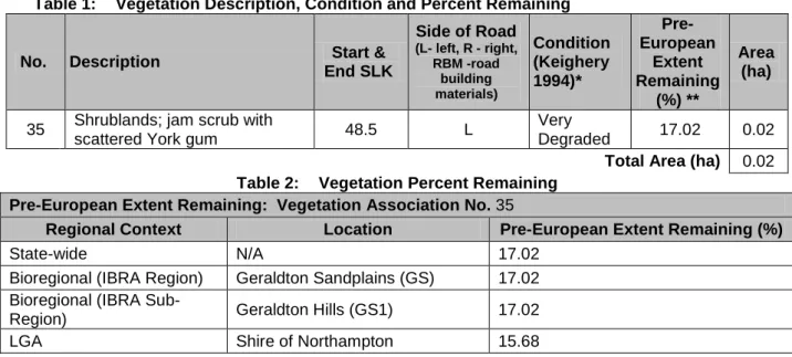
D ETAILS OF V EGETATION A SSOCIATIONS TO BE C LEARED
A SSESSMENT A GAINST C LEARING P RINCIPLES
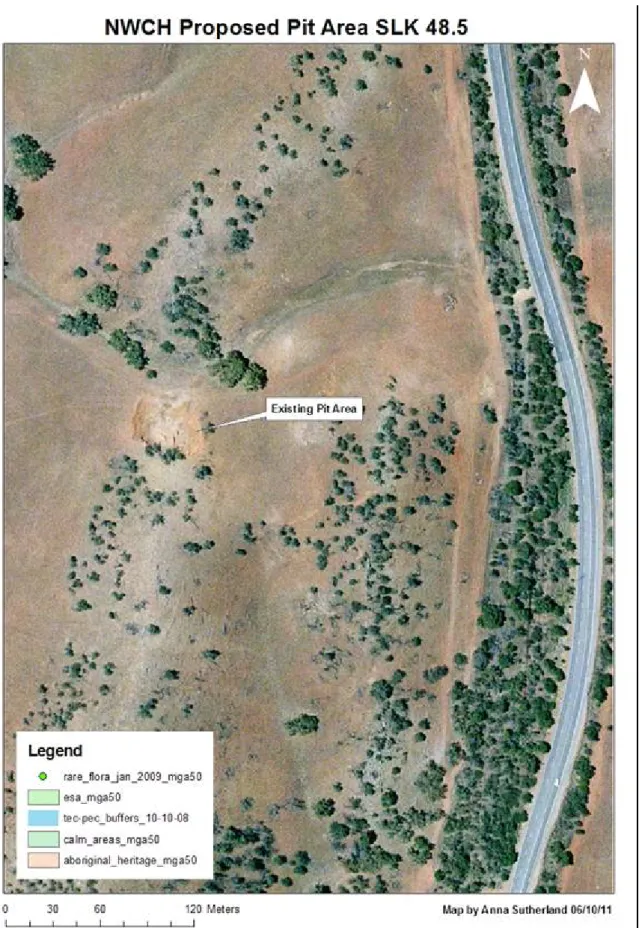
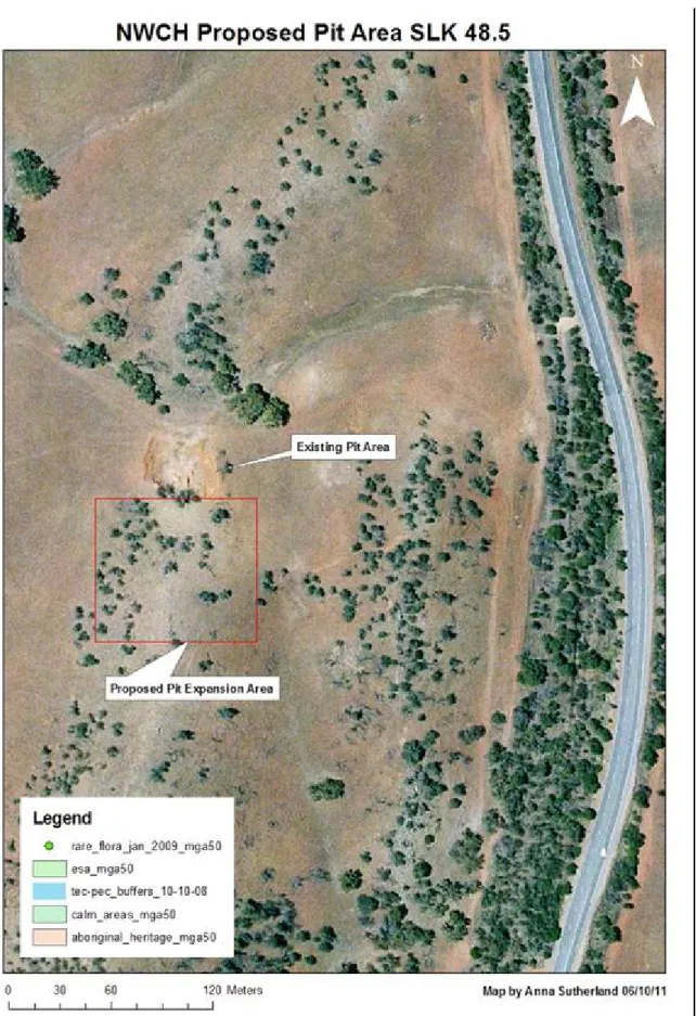
Site visits have shown that the area is within paddocks that have been heavily degraded due to grazing and cropping. Site visit indicated that the proposed material source area is within a crest of a hill, in the middle of a paddock that has been regularly harvested and grazed. Native vegetation should not be cleared if the clearing of the vegetation is likely to have an impact on the environmental values of any adjacent or nearby conservation area.
The site is within an agricultural zone, with no conservation reserves in the vicinity of the proposed work area. DEC data supported the fact that these proposed works would not affect DEC managed lands. A site visit revealed that the site is on top of a hill and not in close proximity to surface water.
The site visit showed that the works will expand an existing material source that currently does not affect surface or underground water. The site visit showed that the proposed work area is on top of a hill and not within a flood plain.
S UMMARY OF M ANAGEMENT A CTIONS
The proposed works will remove the topsoil, remove the material, clean the area and replace the topsoil. The landowner would like the area to be used for feeding his stock. The proposed works are not in an area that is prone to flooding and is located on a hill.
Indicates the assessment that the clearance may differ from or contradict one or more of the principles for clearance. Indicates the assessment that the clearing is in conflict with one or more of the principles for clearing.
ASSESSMENT OF ASPECTS AND IMPACTS
No major sensitive receptors adjacent to the proposed works, but excessive dust may affect vegetation. The requirements of the Earl of Northampton must be met in respect of noise management and construction working hours. Visual amenity The proposed works will result in minor and short-term visual impacts during construction.
Provided traffic management and signaling are used in accordance with main road standards, none of the proposed works pose a significant threat to public safety. The proposed works will serve to increase public safety by improving local roads and pedestrian conditions. Not relevant to the proposed works, the project does not require the use of hazardous substances.
Contamination A search of the DEC Contaminated Areas Database shows that there are 0 contaminated areas identified in the project area. The proposed works are within the owner's land (Ivan Teakle) who has given the main roads permission to access this land for the purpose of obtaining material for the proposed redevelopment works. National Heritage Sites A search of the Australian Heritage Places Inventory database did not identify any sites near the project.
A search of the Department of Sustainability, Environment, Water, Population and Communities Protected Matters Search Tool found no Ramsar wetland(s) in the vicinity of the project. A search by the Department of Sustainability, Environment, Water, Population and Communities Protected Matters Search Tool located 0 endangered ecological communities, 5 threatened species and 5 listed marine species in the vicinity of the project. The project activities are unlikely to have a significant impact on these species and the marine species are listed as "superfluous" and the vegetation present is unlikely habitat for these species.
A search by the Department of Sustainability, Environment, Water, Population and Communities Protected Matters Search Tool located 5 migratory species in the vicinity of the project. It is unlikely that the project activities will have a significant impact on these species, as the vegetation present is unlikely to be habitat for these species. Commonwealth Territories The project is not located on and will not affect any Commonwealth Territories.
DECISION TO REFER
R EFERRAL TO THE D EPARTMENT OF S USTAINABILITY , E NVIRONMENT , W ATER ,
R EFERRAL TO THE E NVIRONMENTAL P ROTECTION A UTHORITY
STAKEHOLDER CONSULTATION
OTHER APPROVALS/PERMITS/LICENCES
Australian Heritage Places Inventory, Heritage Council of Western Australia and Municipal Heritage Inventory Database. The project management measures identified in this EMP are in addition to the Standard Environmental Management Contract Specifications applicable to Category 2 projects. Where applicable, the Main Roads Standard Environmental Contract Specifications (Specifications and 304) should be followed.
Due to the scope and nature of the project, no contingency measures are identified as the inherent environmental risks are small. Due to the scope and nature of the project, there is no requirement for the audit of the implementation of the OBP as the environmental risks are small. Vegetation clearance Ensure that the overall objectives of the alignment and construction works are compatible with the maintenance and, where possible, the enhancement of the biological integrity of the surrounding environment and the reduction of vegetation loss and.
This vegetation should be used during any rehabilitation works and either covered or spread over the affected area. Access to private property and appropriate traffic management measures must be planned and implemented prior to the construction of works. Watering, the use of hydromulch or other forms of mulch to protect loose surfaces should be used as mitigation measures.