Main Roads Wheatbelt South Region is proposing to upgrade and realign the Brookton Highway between SLK. This project, known as the Bulyee section, is approximately 9 km long and much of the work takes place on reclaimed farmland. It is proposed to clear a total of 0.7 hectares of native vegetation from Beard Vegetation Associations 955 and 1023.
This clearance will be carried out using Main Roads Clearance Permit CPS 818/6 and this Preliminary Environmental Impact Assessment (PEIA) found that the project is not considered to be in breach of any of the ten clearance principles. No matters of national environmental importance as protected under the Environment Protection and Biodiversity Conservation Act 1999 (EPBC Act) will be affected. Due to the small scale of the project, the low significance of its impacts on the surrounding environment and the fact that the project is unlikely to generate significant public interest, the project does not require referral to the WA Office of the Environmental Protection Authority (OEPA). A Bed and Banks permit will be sought from the Department of Water as the project area is a declared surface water area and impacts to a watercourse are proposed.
Local Aboriginal informants will be consulted in relation to the registered Aboriginal heritage sites located in the project area to determine whether any project works may affect these Aboriginal heritage sites.
BACKGROUND
DESCRIPTION OF THE PROJECT
P ROJECT L OCATION
The location of the study area and project area are shown in figures 1 and 2 respectively.
METHODOLOGY
D ESKTOP & F IELD S TUDIES
Non-Indigenous heritage was examined using the Australian Inventory of Heritage Places (http://www.environment.gov.au/heritage/places/wa/index.html) and the Western Australian Heritage Council database (http://register .heritage .wa.gov.au/), see Appendix C. The Department of Indigenous Affairs (DIA) database (http://dia.wa.gov.au/AHIS/) was searched to determine whether the project the area contains Aboriginal heritage sites, see Appendix D. The Department of Water (DoW) database was searched. http://www.water.wa.gov.au/idelve/dowdataext/index.jsp) to determine whether the project area contains sensitive water resources (including public drinking water sources or water pollution control areas) or borders important lakes, rivers, wetlands or in designated areas, see Appendix E.
The locations of potential wetlands within the project area have been identified with the Commonwealth Department of Sustainability, Environment, Water, Population and. Community Mapping Tool (DSEWPC), Department of Environment and Conservation (DEC) mapping tool “Native Vegetation Map Viewer” and to view current GIS format files, please refer to Appendix F. A site inspection was conducted to identify all reported plants or significant weeds in or near the project area.
Since the project receives less than 400 mm of rain, this is not considered a problem. The need for a local air quality assessment was determined using the criteria set out in the MRWA Environmental Guideline, Air Quality.
C OMMONWEALTH R EFERRAL
S TATE R EFERRAL
EXISTING ENVIRONMENT
V EGETATION D ESCRIPTION
L ANDFORM AND S OILS
S ITE I NVESTIGATION
CLEARING OF NATIVE VEGETATION
D ETAILS OF V EGETATION A SSOCIATIONS TO BE C LEARED
A SSESSMENT A GAINST C LEARING P RINCIPLES
MRWA Site Inspection (2012) Proposal is unlikely to contravene this Principle. d) Native vegetation must not be cleared if it is all or part of, or necessary for the maintenance of, an endangered ecological community. Given the above, the proposal is probably not contrary to this principle. MRWA Site Inspection (2012) Proposal is unlikely to contravene this Principle. e) Native vegetation must not be cleared if it is significant as a remnant of native vegetation in an area that has been extensively cleared.
Given the above, the proposal is unlikely to conflict with this principle. DoW and DEC shapefiles MRWA Site Inspection (2012) Proposal unlikely to contravene this Principle. g) Native vegetation should not be cleared if the clearing of the vegetation is likely to cause significant soil degradation. MRWA Site Inspection (2012) Proposal is unlikely to contravene this Principle. i) Native vegetation must not be cleared if the clearing of the vegetation is likely to cause deterioration in the quality of surface or underground water.
Natural Resource Management SLIP Land Systems (Accessed 3 July 2012) Proposal is unlikely to conflict with this Principle. j) Native vegetation must not be cleared if the clearing of the vegetation is likely to cause, or exacerbate, the occurrence or intensity of flooding. Natural Resource Management SLIP Land Systems (Accessed 3 July 2012) Proposal is unlikely to conflict with this Principle.
S UMMARY OF M ANAGEMENT A CTIONS
ASSESSMENT OF ASPECTS AND IMPACTS
DEC wetlands form files indicate that there are no wetlands in the vicinity of the project area. Not relevant to the proposed works, the project does not require the use of hazardous substances. A search of DEC's contaminated sites database indicates that there are no identified contaminated sites within the project area.
National Heritage Places A search of the Australian Heritage Places Inventory Database found no sites in the vicinity of the project. A search by the Department of Sustainability, Environment, Water, Population and Communities Protected Matters Search Tool found no Ramsar Wetlands near the project. A search by the Department of Sustainability, Environment, Water, Population and Communities Protected Matters Search Tool found no endangered ecological communities, 13 endangered species and 4 protected marine species near the project.
A search of the Department of Sustainability, Environment, Water, Population and Communities Search Tool for Protected Matters located 7 migratory species in the vicinity of the project. Commonwealth lands The project is not located on and will have no impact on any Commonwealth lands.
DECISION TO REFER
R EFERRAL TO THE D EPARTMENT OF S USTAINABILITY , E NVIRONMENT , W ATER ,
R EFERRAL TO THE E NVIRONMENTAL P ROTECTION A UTHORITY
STAKEHOLDER CONSULTATION
OTHER APPROVALS/PERMITS/LICENCES
ACID SULFATE SOILS MAPPING
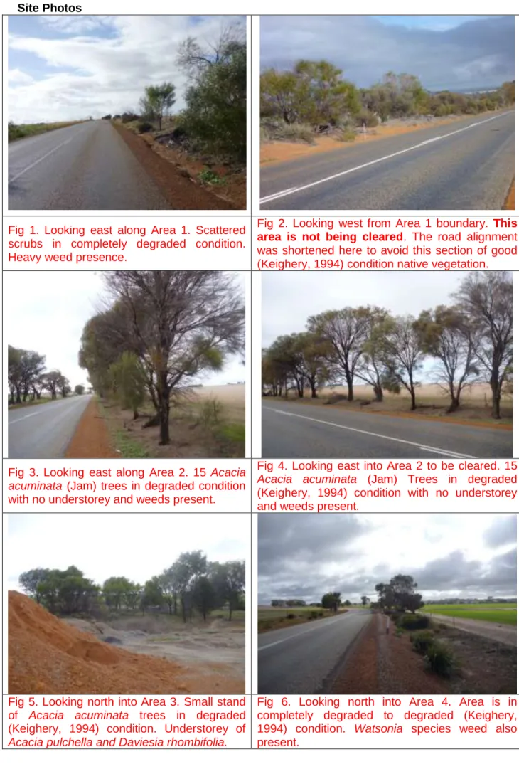
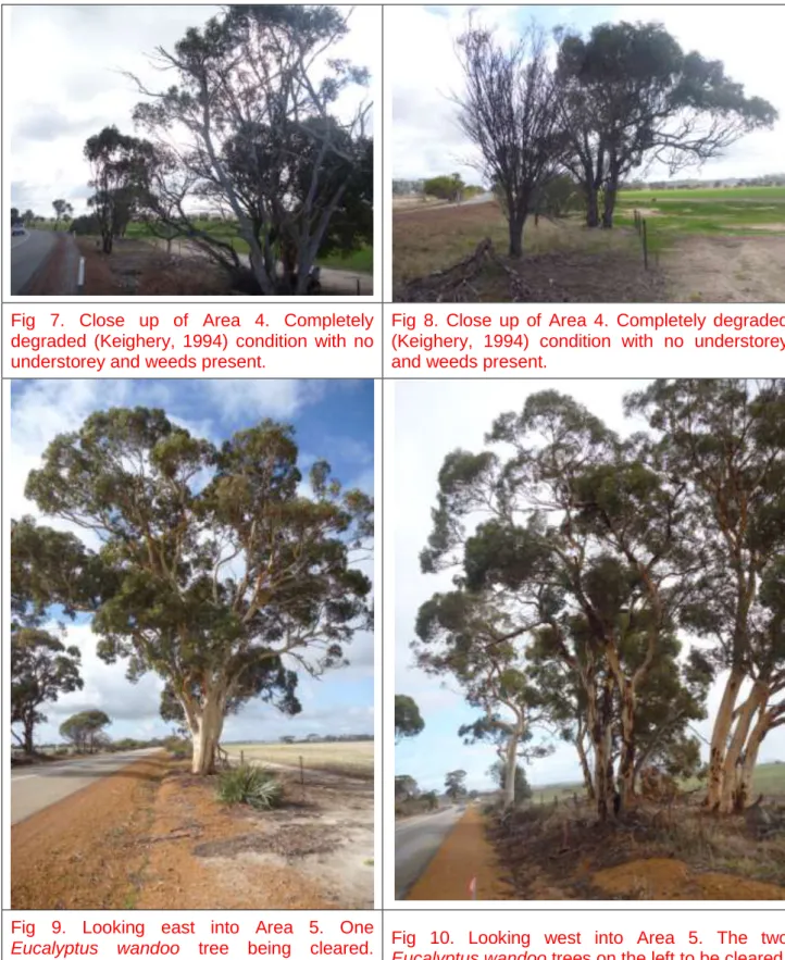
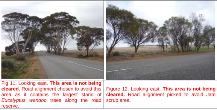
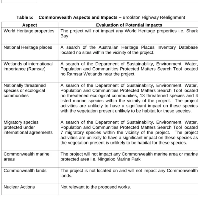
Drive along project areas, stopping at each of the five areas where natural vegetation clearing is proposed to take place. The project area consists of two main types of vegetation, namely Acacia acuminata (pickle tree) thicket and a eucalyptus wandoo tree stand. There is a small area of approx. 20m2 containing jam scrub in a degraded state with an understory of an Acacia pulchella and Daviesia rhombifolia.
The project area is adjacent to farmland and there are numerous larger remnants of intact vegetation scattered in the adjacent farmland that is in better condition than the project area. The project area structure consisted of predominantly mature trees with little sign of natural regeneration. The eastern portions of the project area have some ridges with yellow sandy / gravelly soils and the western portion contains gray sandy soils.
The project management measures identified within this EMP are in addition to the standard environmental management contract specifications used for Category 2 projects. Main Roads' standard environmental contract specifications (Specifications and 304) must be complied with where appropriate. Due to the scope and nature of the project, no contingency measures are identified as the inherent environmental risks are small.
Due to the scope and nature of the project, there is no requirement for the audit of the implementation of the OBP as the environmental risks are small. Vegetation clearance Ensure that the overall objectives of the alignment and construction works are compatible with the maintenance and, where possible, the enhancement of the biological integrity of the surrounding environment and the reduction of vegetation loss and. Project Manager Main Roads Construction work will be undertaken in the summer to develop the potential for.
Surface drainage Maintain the hydrologic regime that exists prior to the construction of the proposal. Access to private property and appropriate traffic management measures must be planned and implemented prior to construction of the works. Main road contractor Any complaints regarding dust will be dealt with as soon as possible.