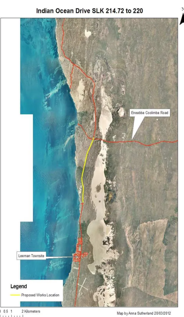
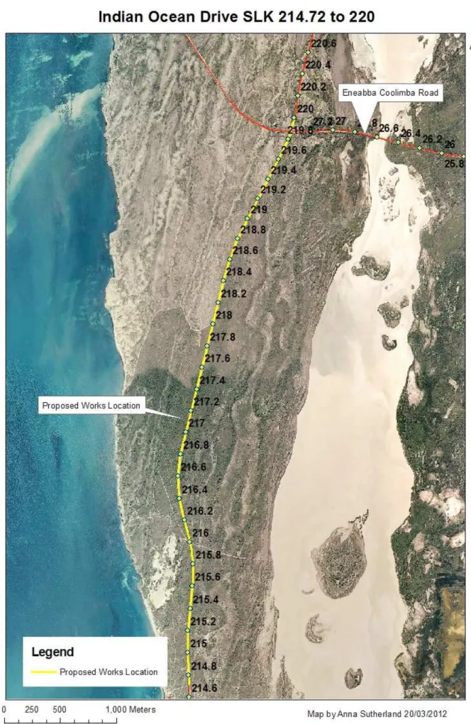
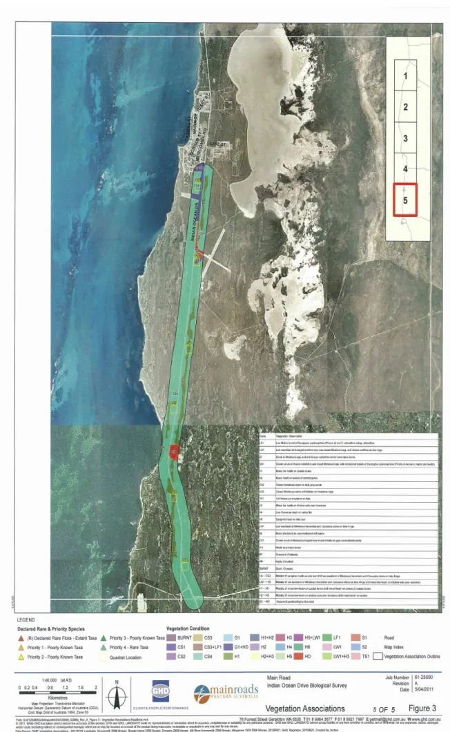
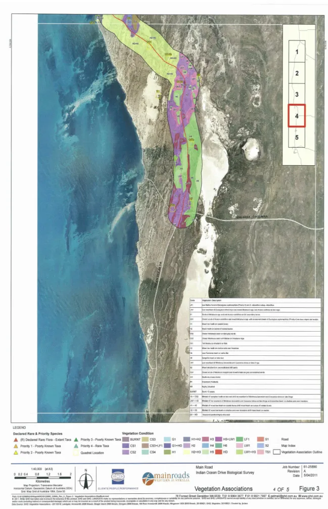
The proposed project within the Shire of Carnamah, includes widening the seal on substandard and problematic sections of the M045 Indian Ocean Drive to 9m as part of a continuous improvement program and, upgrading the Indian Ocean / Eneabba - Coolimba junction at SLK 219.88 to cater for RAV vehicles allowed 27.5 m. A Biological Survey was conducted by GHD in the spring of 2010 to the north and south of the proposed project area (refer to Figures 4 and 5). Where clearing is required (for example in Figure 3), it is estimated that only 1 m of existing vegetation will be required to be cleared.
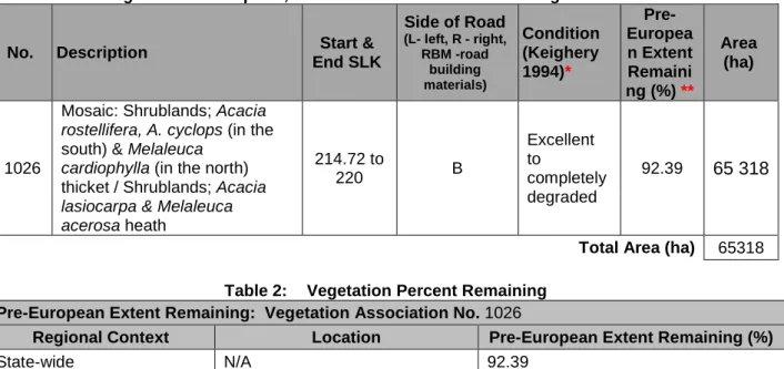
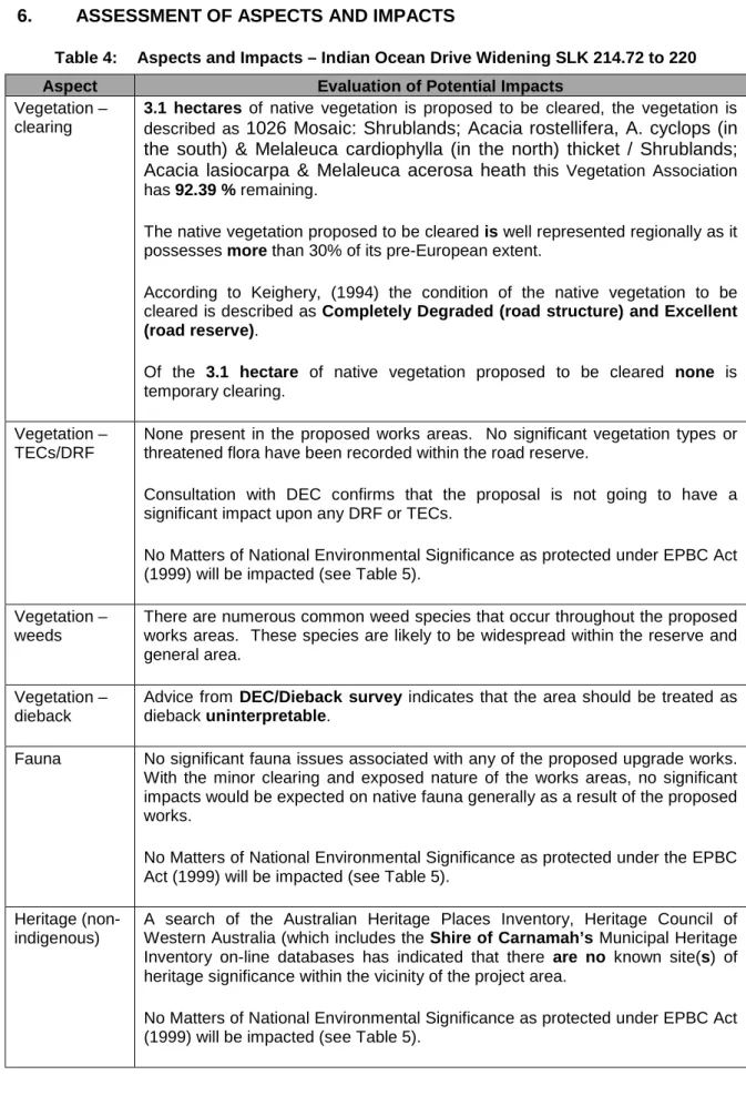
Final project plans have not been received at this stage, but it is estimated that a maximum of 3.1 hectares will need to be cleared. The proposed work area is also in the vicinity of the Čebelarje nature reserve (which will not be affected), which also contains vegetation association 1026. A biological survey carried out north and south of the proposed work area did not discover any declared rare flora or Priority flora and not within threatened ecological community.
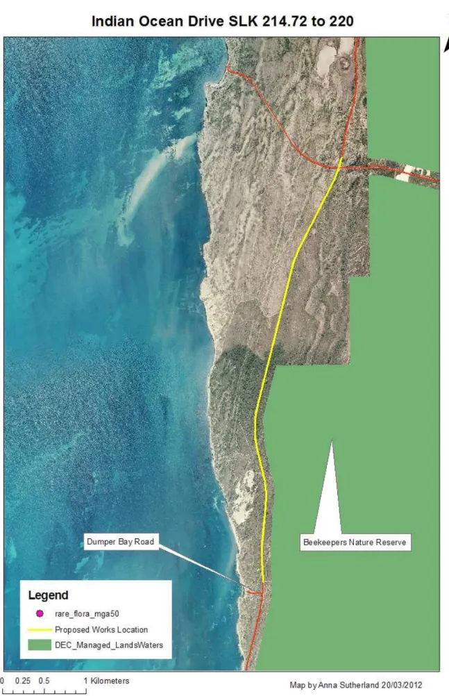
Assessments have shown that the project may be in violation of the following Cleaning Principle because half of the project is in close proximity (approximately 80 m) to the Beekeepers Nature Reserve: h) Native vegetation must not be cleared if the clearing of the vegetation is likely to have an impact on the environmental values of any adjacent or nearby conservation areas. A stakeholder letter should be sent to stakeholders to seek their views on the proposed works.
BACKGROUND
Environmental Impact Study (EIA) is required and if referral to state and/or Commonwealth authorities is required.
DESCRIPTION OF THE PROJECT
P ROJECT L OCATION
METHODOLOGY
P RELIMINARY D ESKTOP S TUDY
The need for a local air quality assessment was determined based on the criteria outlined in the MRWA Environmental Guideline, Air Quality.
C OMMONWEALTH R EFERRAL
A search of the DEC's database of contaminated sites was undertaken. https://secure.dec.wa.gov.au/idelve/css/) to determine if the project area contains or is adjacent to any contaminated sites, refer Appendix J.
S TATE R EFERRAL
EXISTING ENVIRONMENT
D ESCRIPTION
S ITE I NVESTIGATION
The GHD Biological Survey Report stated that the current road structure and maintenance area was at level 6, fully degraded, while the remaining vegetation was category 2, in excellent condition.
CLEARING OF NATIVE VEGETATION
D ETAILS OF V EGETATION A SSOCIATIONS TO BE C LEARED
A SSESSMENT A GAINST C LEARING P RINCIPLES
No declared rare flora (DRF) taxa were shown to occur in the vicinity of the project area as a result of database searches. No declared rare flora taxa were recorded in the project area during the field survey. Habitat – No habitat considered necessary for the continued existence of the DRF is considered to be present in the project area.
REFERENCES GHD Biological Survey 2010 and DEC Rare Plant Database (GIS) The proposal is unlikely to conflict with this principle. d) Native vegetation may not be cut down if it comprises all or part of an endangered ecological community or is necessary for its maintenance. Vegetation clearing is not considered to cause a change in groundwater quality in or adjacent to the project area. Vegetation clearing is not considered to cause a change in surface water quality in or adjacent to the project area.
Clearing vegetation in the project area is not expected to change the frequency or intensity of flooding. The runoff coefficients in the project area are unlikely to change significantly due to the clearing of native vegetation.
S UMMARY OF M ANAGEMENT A CTIONS
Native vegetation should not be cleared if the clearing of vegetation is likely to have an impact on the environmental values of any adjacent or nearby conservation areas. ASSESSMENT Half of the proposed project occurs in the vicinity of the Beekeepers Nature Reserve, however it is 86m away from the boundary of this reserve. Does the assessment indicate that clearing may be non-compliant or inconsistent with one or more of the clearing principles.
Indicates the assessment that the clearing is in violation of one or more of the principles of clearing. The assessment indicates that the clearing is in violation of the clearing principle (g) land degradation, (i) surface or underground water quality or (j) the occurrence of flooding. Will the project involve clearing for purposes deemed to be temporary under condition 13 of CPS818.
ASSESSMENT OF ASPECTS AND IMPACTS
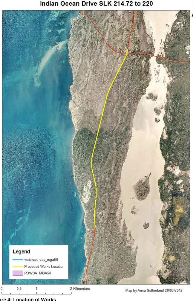
Wetlands According to all the GIS databases, there are no wetlands in the vicinity of the project area. Not relevant to the proposed works, the project requires no hazardous substances to be used. A search of the DEC's database of contaminated sites indicates that there are no identified contaminated sites within the project area.
National Heritage Sites A database search of the Inventory of Australian Heritage Sites located at 1 named site in the vicinity of the project. A search of the Department of Sustainability, Environment, Water, Population and Protected Communities' Search Tool found no Ramsar wetland(s) in the vicinity of the project. A search of the Department of Sustainability, Environment, Water, Population and Communities' Protected Issues Search Tool found no threatened ecological communities, 16 threatened species and 42 listed marine species in the vicinity of the project.
A search by the Department of Sustainability, Environment, Water, Population and Communities Protected Matters Search Tool found 23 migratory species near the project. Commonwealth countries The project is not located on and has no impact on Commonwealth lands.
DECISION TO REFER
R EFERRAL TO THE D EPARTMENT OF S USTAINABILITY , E NVIRONMENT , W ATER ,
R EFERRAL TO THE E NVIRONMENTAL P ROTECTION A UTHORITY
STAKEHOLDER CONSULTATION
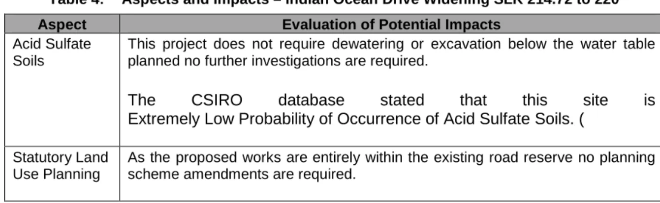
OTHER APPROVALS/PERMITS/LICENCES
Australian Heritage Places Inventory, Heritage Council of Western Australia and the Municipal Heritage Inventory Database Searches. GHD advisory on indicated weeds (spring 2010 - areas north and south of the proposed project). These species were more common in disturbed areas, especially along roads and trails, former pastures and other previously cleared areas.
Tamarix aphylla has the potential to form dense monocultures in riparian areas, displacing native vegetation and reducing valuable wildlife habitat (Australian Government, 2008). It occurs as a weedy tree within the project area, growing adjacent to the Freshwater Point fueling facility.
DIEBACK CONSULTANT / DEC ADVICE ON DIEBACK
Phytophthora cinnamomi (“Dieback”) disease is generally confined to the southwest of the state, in areas that receive an average annual rainfall of more than 400 mm (Dieback Consultative Council, 2001). Since the vegetation associations identified by Beard (1976) are known to have a high percentage of species from the Proteaceae and Myrtaceae families, and the Eneabba area receives an average annual rainfall of 498 mm (Bureau of Meteorology, 2010), the location of the project area can be considered susceptible to the impact of the Phytophthora cinnamomi pathogen. The project management measures identified within this EMP are in addition to the standard environmental management contract specifications used for Category 2 projects.
Main Roads' standard environmental contract specifications (Specifications and 304) must be complied with where appropriate. Due to the scope and nature of the project, no contingency measures are identified as the inherent environmental risks are small. Due to the scope and nature of the project, there is no requirement for the audit of the implementation of the OBP as the environmental risks are small.
Vegetation clearance Ensure that the overall objectives of the extension and construction works are consistent with maintaining and, where possible, enhancing the biological integrity of the surrounding environment and minimizing the loss of vegetation and. Project Manager Major road construction works will be undertaken in the summer to reduce the potential for. This vegetation will be used during any rehabilitation work and will either be mulched or re-scattered as per the TDP/Revegetation plan.
If the clearing is in accordance with the main purpose permit (CPS818), it must be ensured that § 14 of the permit is complied with regarding Dieback, other pathogens and weed control. Surface drainage Maintain the hydrological regime that exists prior to the construction of the proposal. Access to private property and appropriate traffic management measures should be planned and implemented prior to the construction of the works.
Contractor Main Roads Any complaints regarding dust will be dealt with as soon as possible. Contractor Main Roads A water tanker/fire brigade unit will be on site at all times. Final cleaning will be to the satisfaction of the Project Manager and the Site Superintendent.