Introduction
Preliminary Works Approval
Background
Accommodation Village at L 29/145, just north of the (existing) airstrip and south of the Bottle Creek project area. Upgrade of the existing runway on L 29/137 to aerodrome standard (CASA) and maintenance of the existing main access runway (also L 29/137). A reverse osmosis (RO) plant will be installed and in the meantime the brine will be pumped up and transported by truck to be discharged into one of the mining lakes.
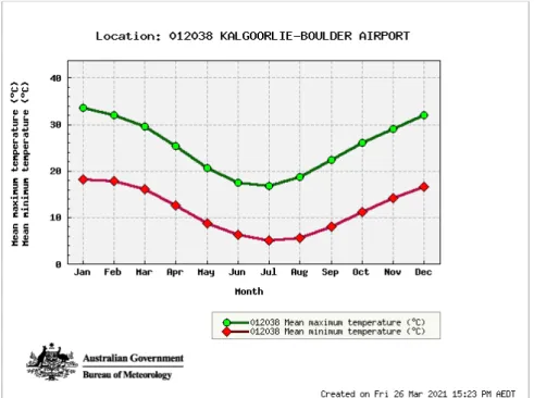
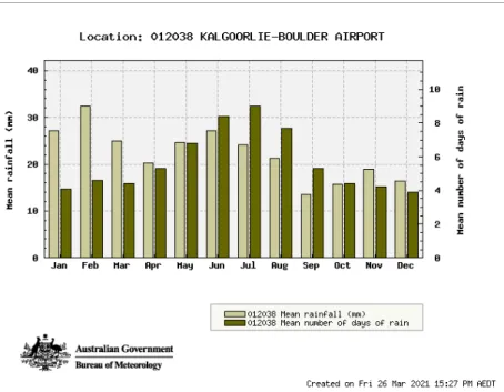
The project area is within the Eastern Goldfields sub-region of the Eremaean province of Western Australia, as defined by the Interim Biogeographical Regionalization of Australia classification system (Thackway and Cresswell 1995). Menzies Weather Station (012052) is the closest Bureau of Meteorology (BOM) station to the project area, but has not recorded any data as of April 2019. Topography in the area of the site is characterized by low hills and rises with broad valleys and indistinct drainage lines.
Due to its distance from Lake Ballard, the project activities and proposed clearance are unlikely to have a negative impact on water quality or quantity, and thus the environmental values of the lake. However, this species is restricted to elevated banded ironstone chains, which do not occur in the project area nor in the proposed village site. However, the BIF does not extend to the Project's tenements and the Project activities and liquidation are not likely to directly or indirectly affect the values of the BIF.
Detailed biological surveys have been carried out from 2019 to 2021 over the project area across several seasons. As most areas are heavily grazed, weeds (and any soft herbaceous plants) are preferentially grazed, and high weed loads are not evident within the Project area. Wildlife has been recorded and anecdotally noted within the project leases, which co-occur in an active pastoral lease.
Less is known about Aboriginal land use, but evidence of artefact dispersals in the local area also remains. However, the Aboriginal Heritage Due Diligence guidelines (Department of Planning, Lands & Heritage and Premier and Cabinet 2013) were applied to the proposed project and a consultant was employed to consult with and work with local elders to conduct investigations of the project areas. The treatment plant is near the Rebecca Fractured Rock Aquifer with the Rebecca Paleochannel below the Bottle Creek drainage line.
During start-up and operation of the waste treatment plant and irrigation sprinkler field, there is the possibility of equipment or infrastructure failure that could cause a leak or release to the ground.
Applicant
Activities
Prescribed Activities - WWTP and Irrigation Field
The main stakeholders identified for the project are the Shire of Menzies and the pastoral leaseholders within which the project is located (Perinvale and Riverina Stations), both currently owned by the Zenith Group. There is no native title over the project area, but Aurenne ALT Resources has engaged with traditional owners from the Leonora area who are connected to the land where the project is located. The project is located in the arid to semi-arid Goldfields region and experiences hot, dry summers and cool, wet winters (Cowan 2001).
The project lies almost entirely within the Kalgoorlie Terrane of the Yilgarn Craton, comprising Archean mafic-ultramafic intrusive and volcanic rocks with minor interbedded sediments that make up the Ida-Ullaring Mountain Greenstone Belt. Existing surface drainage in the area has been modified from previous mining activities on site and further surface water management is proposed for the Project to ensure both the integrity and safety of the pit, and to maintain ecological hydrological regimes. The location of the project is considered low risk due to its distance from important hydrological environmental receptors (surface and underground), i.e.
The results indicate that the project area is not known to have outstanding biodiversity values across flora, vegetation and fauna habitats. No conservation reserves are near the project area; The project area sites within pastoral stations filled with cattle and wild donkeys. There is one Schedule 7 species listed under the WA Biodiversity Conservation Act 2016 and one species listed on the DBCA's Priority Fauna List potentially occurring in the project area or surroundings.
All are likely to occur at different densities and note that the project area is an active pastoral lease that manages a herd of cattle with a large resident herd of wild donkeys. The Project area is within Perrinvale and Riverina pastoral leases (both held by Zenith Group), is currently managed for cattle and contains a high feral donkey population. The Project does not allow campfires and maintains equipment and fire extinguishers to prevent accidental ignition.
The project was considered for compliance with the noise regulations under the Mines Safety and Inspection Act 1994, the Mines Safety and Inspection Regulations 1995 and. The project is in Ularring, a small Western Australian rural location within the local government area of Menzies, located approximately 475 km from Perth, covering an area of 26,564.35 km2. Two recent Aboriginal heritage surveys have been undertaken for the project by A J Rayner Consulting in 2019 and further survey in 2020 (Appendix C).
The project is within the locality of Ularring, a small rural Western Australian location within the local government area of Menzies, located approximately 475 km from Perth, covering an area of 26,564 km2.
Premises
Legislative Context and other Approvals
Stakeholder Engagement
Stakeholders
Biophysical Environment
- Biogeography
- Climate
- Implications for risk assessment
- Geology
- Implications for risk assessment
- Hydrogeology
- Surface Water
- Ground Water
- Hydrogeological implications for risk assessment
- Flora and Vegetation
- Vegetation types and Condition
- Flora
- Conservation Significant Flora, Ecological Communities, and Areas
- Introduced Flora
- Fauna and Fauna Habitats
- Short Range Endemic and Subterranean Fauna
- Introduced Fauna
- Biodiversity value implications for risk assessment
- Environmental Threats and Other Factors
- Weeds
- Fire
- Feral Animals
- Dust
- Noise
- Hydrocarbon & Chemical Management
- Implications for risk assessment
- ESA, Conservation Areas
Average daily evaporation rates in the region vary between 12.5 mm in January and 2.6 mm in June (BOM 2021). The belt is bounded to the east by the Ballard/Zulieka fault and the Mt Ida fault to the west. The Mt Ida Shear is a major structural break and forms the boundary between the Kalgoorlie Terrane and the Southern Cross Terrane to the west.
The proposed project area lies in the headwaters of Bottle Creek, which drains to Lake Ballard. It is located in the Salt Lake Basin Surface Water Management Area (DWER 2019), which is not in a proclaimed surface water management area. The PMST results listed that one threatened flora species (Rincinocarpos brevis) may be present in the area.
Although no rare or threatened species were identified in the survey, three endangered species of fauna and five migratory bird species identified under the EPBC Act may occur in the project area or vicinity. The clearing of native vegetation is likely to result in the loss of small vertebrate fauna on the site that cannot move away during the clearing process. To ensure that an adequate, informed range of data is collected for the Project, both an underground and SRE field survey were commissioned in 2021 and the planning and development of the Project MP/MCP will be associated with the mining/ dewatering components (Bennelongia and Phoenix Environmental (in preparation)).
The project will manage weeds through vehicle and plant hygiene/cleaning procedures upon entry and through weed monitoring after significant rainfall. The project will manage water points and waste disposal so that there is no net increase in wildlife resulting from the activities. Ambient noise is low and consistent with a remote location in the vast land use zone.
Social Environment
Aboriginal Heritage
European Heritage
- Implications for risk assessment
The potential for emissions to affect sensitive receptors has been assessed in accordance with the DWER Risk Framework. Dust minimization and management measures are proposed taking into account control measures when undertaking the risk assessment detailed in section 11.1.2. Upon completion and compliance with this works approval, a category 5 facilities license under Part V of the EP Act will be required to authorize emissions associated with the operation of the premises.
The main emissions considered during the operation of the property are the potential for uncontrolled leakage of untreated waste water. The property is located in the water source Goldfields, Rebecca, Combined - Fractured Rock West - Alluvium (https://maps.water.wa.gov.au/#/webmap/register). Predominant winds in relation to sensitive receptors can affect potentially adverse dust and sound effects with low odor potential.
Dust and noise are airborne, but with a short construction duration, low volume noise, no night works and no sensitive receptors, there is little potential for impact. The groundwater is at depth and therefore with the volumes of waste water handled, the likelihood of potential impact is low. Aurenne is of the opinion that with the existing and proposed management controls, the remaining environmental risks associated with the prescribed activities are acceptable.
The works approval calls for a post-construction and commissioning period to commence upon completion of the independent components of structures. Department of Health, 2011, Guidelines for non-potable use of recycled water in Western Australia. DoW, 2009, Water Quality Protection Note 111 Landfills for Disposal of Perishable Materials Department of Water, Perth.
Department of Water and Environment Regulation (DWER), 2019a, GWL63902(6) License to take water granted by the Minister under section 5C of the Water and Irrigation Rights Act 1914. Access: https://cps.dwer. wa. gov.au/main DWER, 2019, Landfill Waste Classification and Waste Definitions 1996 (amended 2019).
Environmental Siting
Emission Sources, Pathways, Receptors and Controls
Emissions
The key indoor construction emissions considered in this report are dust and noise from construction activities, including installation and use of equipment and vehicle movements. A risk assessment for the operational phase has been included in this decision report, but the license conditions will not be finalized until DWER has assessed the license application.
Pathways
- Pathway by leakage, spills, unexpected discharge or clearing
- Pathway by air/wind dispersion
Receptors
- Public drinking water source areas
In the event of leaks from either facility, the first priority is to isolate the system and stop the release of wastewater. An investigation and necessary works (e.g. repairs, improved capacity, etc.) will be undertaken to prevent further incidents. The overall risk assessment is low given the proposed activities for the construction and operation of the WWTP and the spray field and the proposed control and management measures.
Based on the risk assessment and management/controls developed to address the activities that may have an impact on the environment, it is believed that Works Approvals can be issued for the application activities.
Risk Assessment
Risk event
- Pathway & Receptor
- Management & Controls
- Rating of this risk event
Conclusion
Fee Calculation
A PROOF OF OCCUPIER
PREMISES MAP
NA
RELATED APPROVALS
EMMISSIONS & DISCHARGES
SITING
SUPPORTING INFORMATION
COST CALCULATION
