Overview
Summary of the Precinct Plan
Exhibited Materials
Exhibition Period
Exhibition Venues
Public Notice
Notification of Land Owners
Notification of Key Stakeholders
Exhibition Information Sessions
Number of submissions
Response to Submissions
Issues raised in Submissions
This section identifies the issues raised in the submissions, as well as those raised in ongoing discussions with the Council, government agencies and key stakeholder groups. In answering the questions raised, the Ministry formed a position by balancing a set of competing views in the context of state planning policies and guidelines, with additional expert advice if necessary. The changes to the site planning package since the exhibition are summarized below together with a discussion of the key issues raised.
Appendix B provides a summary of issues raised in individual submissions, together with a cross-reference to the relevant section. Reference is made to the final ILP and associated documentation for how the post-exhibition changes to the plans affect the individual properties.
Indicative Layout Plan
North West Transport Options
Drainage
Flood Evacuation
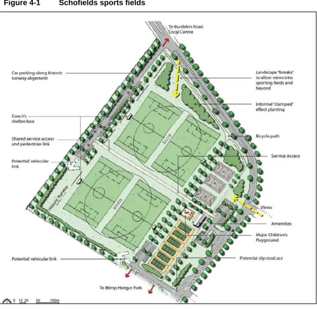
Sporting Fields
Ownership of Riparian Corridors
Local Parks
Based on the contributions, minor changes were made to the size and location of some public and private open spaces. These changes generally reflect other changes that have been made to the ILP, such as the placement of a road or the relocation of other facilities such as sports fields (see Section 4.3).
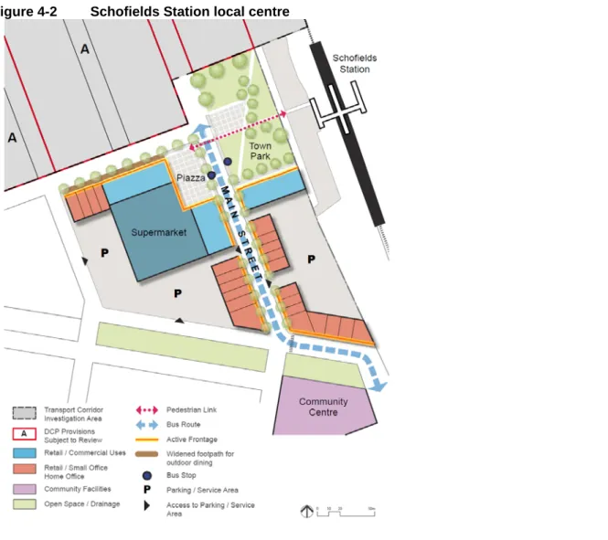
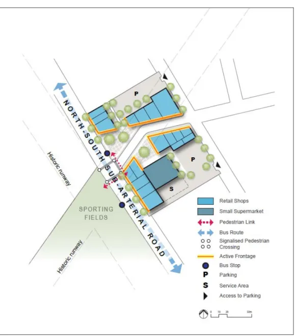
Local Centres
The location of the Burdekin Street local center has shifted slightly to reflect changes in surrounding land uses. The Burdekin Street Local Center will provide a hub for the southern part of the area and will benefit from access to the primary school and playing fields. The Burdekin Street local center covers an area of 1.6 hectares (a setback of 0.2 hectares) with a GLA of 5,600m² and allows for a small supermarket and supporting retail shops.
Road Layout
Heritage
Primary School
Rail Noise Buffer
Westminster Bridge
Biodiversity Certification
Nirimba Education Precinct
Infrastructure
Section 94 Contributions
Planning Policy
Development Control Plan
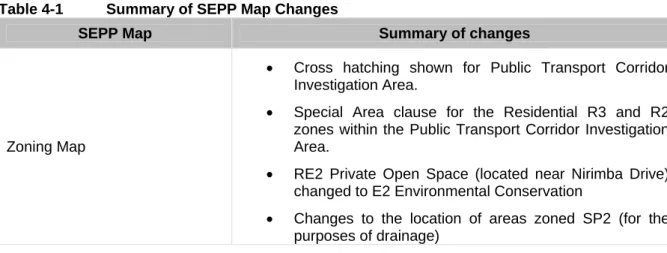
SEPP Instrument Changes
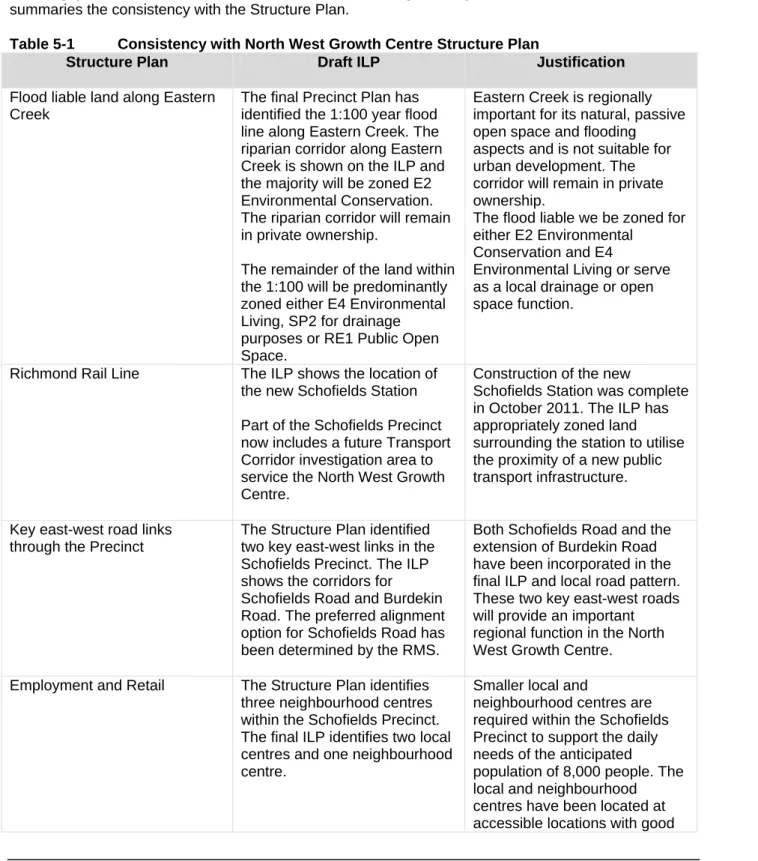
Changes to RE1 zoned areas, according to the final ILP, especially the relocation of sports fields. The north-south collector road is no longer included in the land reserve acquisition map (to be funded by developers). The park on the east side of the site adjacent to the rail corridor is no longer identified as ENV (as per OEH advice).
Areas within infrastructure corridors (Schofields Road, Burdekin Road and Grange Avenue) no longer included as ENV. R2 Low-density residential areas (shaded as Medium Density on the ILP) are subject to a density control of 30 dwellings per hectare.
Growth Centres Structure Plan
Growth Centres Development Code
Development at minimum density according to the draft SEPP will achieve a yield of 2763 dwellings in the Area. Development at higher densities than the minimums set out in the draft SEPP Amendment will be possible and will result in greater yields. Other community facilities such as schools and open space, along with major bus stations are positioned to form a focus.
The final ILP names the high street and side streets within local centers and defines access routes for circulation, access to parking and access to services. The blocks are designed to maximize the orientation of the plots in the north-south or east-west direction in accordance with the existing cadastral boundaries to achieve adequate solar access. The building height, setback, minimum landscaped area controls included in the proposed SEPP amendment and the draft DCP will achieve control over the extent and intensity of single-family housing types.
The cross sections and dimensions of the roads developed for Schofields may differ slightly from the cross sections in the Development Code.
Other Relevant SEPPs
Section 117(2) Directions
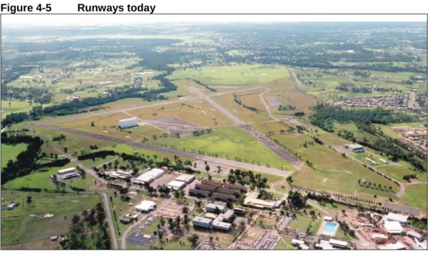
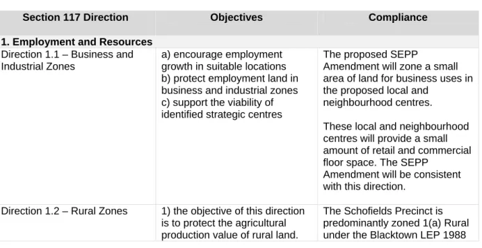
The rezoning of the land for residential and commercial purposes is inconsistent with the direction.. inconsistency is justified, as it is consistent with the Northwest Structure Plan, part of the Growth Center SEPP, and with the draft Northwest. The rezoning of areas for residential and commercial purposes is inconsistent with the direction.. inconsistency is justified, as it is in accordance with the Northwest Structure Plan, part of the Growth Center SEPP, and with the draft for the Northwest. A remnant section of the WWII airstrip will be kept in the flood plain with parts of the rest of the runway interpreted in the new urban planning.
The district's Aboriginal cultural heritage assessment identified a number of areas of high to moderate and low Aboriginal cultural heritage value. The plan is generally consistent with the direction as it .. implements the adopted North West Structure Plan and Growth Center Development Code. A range of housing types is encouraged and .. development of the area will utilize existing and/or planned utility infrastructure.
Section 117 Directional objectives Compliance based on a strategy that takes into account the objective of providing different types of housing and is approved by the Director-General, which is the adopted North West Structure Plan. The plan is consistent with the direction, as it allows residence in residential zones R2 and R3 without consent. The objective and requirements of the direction are achieved by implementing the requirements of the Growth Centers Development Code and compliance with the Northwest Structural Plan.
Specifically, the SEPP amendment proposes to zone land for higher density residential development within the walking catchment of Schofields Station, community centers and neighborhood centres. The former Schofields Aerodrome is part of the Schofields Precinct but no longer functions as one. Flood modeling for the Schofields Precinct has been carried out in accordance with the Flood Prone Land Policy.
The potential bushfire impacts of the proposed development in the Schofields Precinct have been assessed. The plan is in accordance with the direction and does not contain any provisions that . agreement, consultation or. The inclusion of schedule 1, which allows for the specification of specific applications, is in accordance with the standard instrument and direction.
The objective of this direction is to give legal effect to the vision, land use strategy, policies, outcomes and actions contained in the Metropolitan Strategy. Schofields Precinct lies within the Blacktown LGA and as such this direction applies.