Reproduction of this document for other purposes is only permitted with the written permission of The Hills Shire Council. In developing this strategic statement, research has been undertaken in a number of key areas to provide the vision for the future of the Hills Shire. The Hills Local Strategy has been the Council's main document to communicate the future planning directions for the Shire since it was adopted in 2008.
To ensure services and infrastructure meet society's changing needs, strategy 6.1 aims to deliver social infrastructure that reflects society's needs now and in the future. The Council's Local Strategic Planning Statement, based on this Housing Strategy, provides a line of sight between the regional and district priorities and places them in the unique local context of the Hills Shire. Provide social infrastructure that reflects the community's needs now and in the future (Action 8).
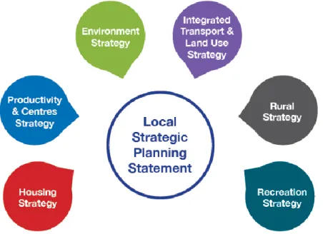
3 Productivity & Centres Strategy
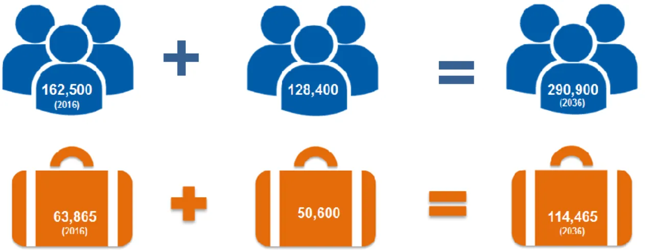
To ensure that the council is accountable to the community and meets legislative requirements and to support elected council representatives in their role in the community. With improved transport links, businesses in The Hills will be able to access the central and western city within reasonable timeframes, ideally positioning the region to become a leading service economy. The resident workforce includes all people living in the Shire aged 15 or over who are employed or looking for work and available to start.
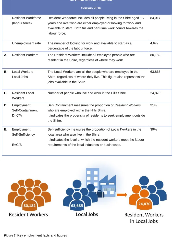
Resident workers Resident workers include all employed persons who are resident in the Shire, regardless of where they work. Local workers are all people who are employed by the Shire, regardless of where they live. Self-sufficiency measures the proportion of local workers in the local area who also live in the Shire.
Local employees are all people who work in the Shire, regardless of where they live. Viewed as a percentage of jobs available in The Hills, manufacturing appears to be in. However, a more detailed look at the manufacturing industry in The Hills reveals that the total number of available jobs, while fluctuating, has remained fairly stable over the past 15 years. year.
Despite fluctuations in the size of the workforce, manufacturing continues to add value to the local economy, as shown in Figure x. Resident Workforce are all people who live and work or can work in the Shire. Resident Workers are all employees who live in the Shire, regardless of where they work.
Unemployment in The Hills has historically remained much lower than that of the Greater Sydney region, although fluctuations in the unemployment rate have followed similar trends.
4 Recreation Strategy
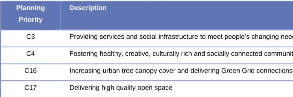
C3 Providing services and social infrastructure to meet the changing needs of people C4 Promoting healthy, creative, culturally rich and socially connected communities C16 Increasing the canopy of trees in the city and establishing green grid connections C17 Providing high-quality open space. Councils will lead the delivery of the Greater Sydney Green Grid through land use planning and infrastructure investment mechanisms such as development and land use controls, dual use agreements for open space and recreational facilities, open space direct investment and other funding mechanisms such as local development grants and voluntary planning agreements. The NSW Government supports the provision of regional open space and green network connectivity through the Metropolitan Greenspace Program.
Planning Priority C17 delivers on Objective 31 of the Regional Plan and reiterates the importance of open space in supporting healthy and active lifestyles, and bringing communities together. High density areas: Public open space is used like a shared backyard, providing a green communal living space. Land release areas: Provision will need to be made to accommodate new open space areas to meet the wide needs of the community – from local playgrounds to sports grounds.
While it is essential to increase the quantity, quality and accessibility of open space to meet the demand of the growing population, the Neighborhood Plan recognizes the difficulties involved. These locations require a combination of new open space and innovative use of existing open space. The plan also highlights that open space on the school grounds is a potential asset that can be shared by the wider community outside of school hours.
Of particular importance to the Open Space and Recreation Strategy is Principle 4 – Facilities to match the lifestyle of the Shire. The main aim of this principle is to ensure that residents within new growth areas (release zones and railway zones) are not supplied with social infrastructure such as open space.
5 Integrated Transport & Land Use Strategy
The strategies seek to bring together transport and land use plans, as outlined in the Future Transport 2056 project, and ensure the identification and protection of future corridors. C9 Ensuring integrated land use and transport planning and 30-minute city C10 Growing investment, business opportunities and jobs in strategic centers C19 Reducing carbon emissions and efficient management of energy, water and waste. Planning priority C1 within the District Plan enforces Objectives 1 to 4 of the Regional Plan.
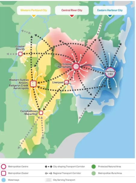
In terms of transport, actions related to the Hills include prioritizing public transport. investment to improve connectivity to Greater Parramatta from Norwest. This priority is at the heart of the development of a strategy to integrate land use and transport. Actions include working with State Government to protect future transport and freight corridors and supporting innovative approaches for businesses to improve operations. transport network performance.
Priority corridors identified in the plan include the North South rail link from Schofields to Western Sydney Airport and the Outer Sydney Orbital. Future Transport 2056 sets out a 40-year vision for the transport system to support the land use vision contained in the Greater Sydney Region Plan. Projects identified in Future Transport 2056 relevant to the hills are shown in the following table.
The following table describes the Strategic Directions, Community Outcomes and Strategies from Hills Future that are relevant to the Integrated Land Use and Transport Strategy. Of particular importance to the Integrated Transport and Land Use Strategy is Principle 2 – Balancing high and low density housing.
Assessment and approval pathways for vegetation clearance activities now depend on the nature, location and extent of the vegetation clearance activity. The Biodiversity Conservation Act 2016 and Regulation 2017 set out the framework for addressing the impacts of development and deforestation on biodiversity. It establishes a framework to prevent, reduce and offset the impacts of development on biodiversity through the Biodiversity Offset Scheme.
The Biodiversity Compensation Scheme creates a transparent, consistent and science-based approach to biodiversity assessment and offsetting for all types of development likely to have a significant impact on biodiversity. Together with the Coastal Management Act 2016, the SEPP established a new land use planning framework for the management of the Shire's Hawkesbury River foreshore and wetlands. The following table outlines the strategic directions, community outcomes and strategies relevant to the strategy.
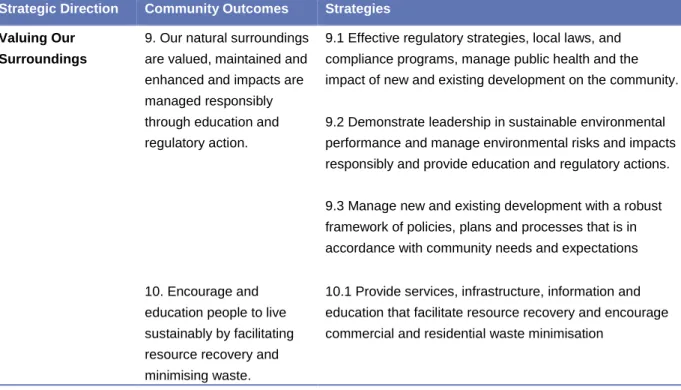
Our natural environment is valued, maintained and enhanced, and impacts managed responsibly through education and legislative action. The local strategy has provided a sound framework for the preparation of the Council's standard instrument local environment plan (LEP 2012) as well as consideration of individual plan proposals. The strategy was supported by a number of key directions, including the Waterways direction and the Environment and Open Space direction.
The Local Strategy has provided a solid framework for the preparation of the Council's standard instrument Local Environmental Plan (LEP 2012) and the consideration of individual planning proposals since then. The local strategy was underpinned by a number of key directions, including waterways and environment and leisure directions.
7 Rural Strategy
To increase the security of existing agricultural land and minimize land use conflicts, the NSW Government has developed a 'right to farm' policy which supports the right of farmers to continue farming as long as they apply good management practices. This may mean a loss of amenity for surrounding land uses; however, it emphasizes the importance and need for agricultural land and activities. The Sydney Regional Environmental Plan No 9 – Extractive Industry (No 2-1995) (SREP 9) identifies land that contains significant reserves of extractive material such as sand, clay and shale and aims to facilitate the development of these resources in the vicinity of urban residents of Sydney.
It ensures that these industries are carried out in an environmentally acceptable manner and that urban development does not adversely affect the ability of extractive industries to realize their full potential. Importantly, it also bans extractive industries in environmentally sensitive areas linked to the Macdonald, Colo, Hawkesbury and Nepean rivers. This legislation also requires that after the cessation of extractive activities, the land is capable of supporting sustainable agricultural production and land uses consistent with the character, landscape and natural quality of the Maroota locality.
Sydney Regional Environmental Plan no. 20—Hawkesbury-Nepean River (No. 2—1997) (SREP 20) aims to protect the environment of the Hawkesbury-Nepean River system by ensuring that the impacts of future land use are considered in a regional context. Specifically, this SREP recommends strategies to help protect and enhance the Hawkesbury River and its Of particular importance to this rural land strategy are those related to total catchment management, rural residential development, and recreation and tourism.
The table below describes the Strategic Directions, Community Outcomes and Strategies that are relevant to the Rural Lands Strategy. Promote awareness of the region's business opportunities and provide information and support to attract new investment and jobs.