From a socio-economic perspective, the community relevant to this marine park is that of the Upper Spencer Gulf region. As a result of the expected extensive development over the next decade in the Upper Spencer Gulf, the Upper Spencer Gulf Marine Park Sanctuaries and Habitat Protection Areas will be declared a Special Purpose Area. The overall social impact of the Upper Spencer Gulf Marine Park on the communities living in the region is expected to be low given the magnitude of the expected economic impact.
Introduction
Marine Park Planning Process
Peak stakeholders have been invited to provide early advice on their priority marine park zones. The Scientific Working Group and the Marine Parks Council of South Australia are independent advisory bodies that advise the Minister. In finalizing the draft management plans, discussions were held with members of the Marine Park Steering Committee as representatives of the relevant government agencies.
Policy Commitments
- Displaced Commercial Fishing Policy Framework
Method of Assessment
Ecological
Activities and uses: determining the range of activities and uses that may have an impact on the marine environment under current management regimes, and then determining how the marine park zoning and management arrangements will affect them. Baseline: determination of the current status of the marine species, habitats and ecosystems in the marine parks; against which we compare future changes. Predictions: assessment of the implications of the marine park zoning and management arrangements over 5, 10 and 20 years on species, habitats and ecosystems against the case of no marine park zoning and management arrangements.
Economic
Value of) Output is a measure of gross receipts of goods and services produced by commercial organizations (eg value of processed seafood) and gross expenditure by government agencies. Gross regional product (GRP) is a measure of the net contribution of an activity to the regional economy. Further details of the economic method can be found in Section 3.2 of the Main Report.
Social
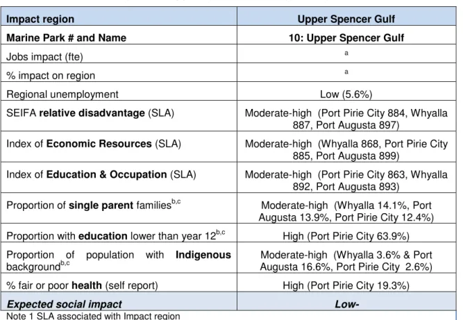
The social vulnerability of the Impact Region associated with each Marine Park is determined through a combination of socio-economic indices for the area (SEIFA), population (health, family, education, indigenous status) and economic characteristics (unemployment, job loss). The SEIFA indices presented here provide a measure of socio-economic disadvantage for the Impact Regions associated with Marine Parks at the time of the 2006 Census4. Each of them provides a slightly different picture of the socio-economic profile and potential vulnerability of each region.
Upper Spencer Gulf Marine Park Description
Ecological Description
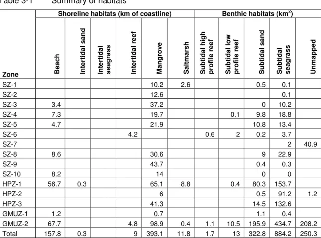
Each of these titles was divided into categories that could be more easily evaluated, either directly or as a service. A more detailed discussion of these goods and services is provided in Annexes 4 (habitat-specific information) and 5 (consolidated discussion) of the Main Report. Intertidal habitats are expressed as shoreline lengths to comply with DENR (2010a) and/or due to limitations of available GIS data, and therefore do not provide a complete indication of the extent of these habitats within the park.
Socio-economic Profile
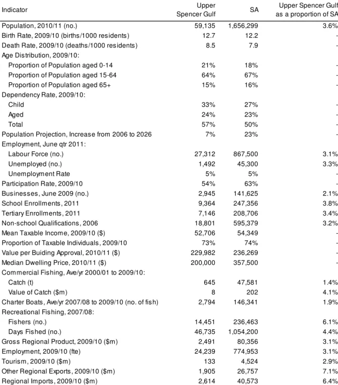
The regional economy of the Upper Spencer Gulf is relevant to the Upper Spencer Gulf Marine Park (MP10). The total population in the Upper Spencer Gulf region is expected to increase by about 7 percent by 2026, while SA's population is expected to increase by about 23 percent. The unemployment rate in the Upper Spencer Gulf region was 5.5 percent in the June quarter of 2011, similar to the state rate, but more than half of what it was in 2003 (June quarter).
Summary of Impacts
Ecological
- Habitats
- Species
- Ecosystems
- Case study - Giant Australian cuttlefish and subtidal reef at
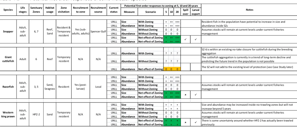
Each of these species is described in more detail in Appendix 3 of the Main Report. Nevertheless, the impact assessment identified that species currently fished are most likely to show a direct first-order response over the next 20 years (relative to current uses) to the proposed management schemes and zoning (see Annex 1.3 of the main report). . . Nevertheless, as required for this assessment, some predictions have been attempted based on a number of assumptions listed in Appendix 1.3.13 of the Main Report.
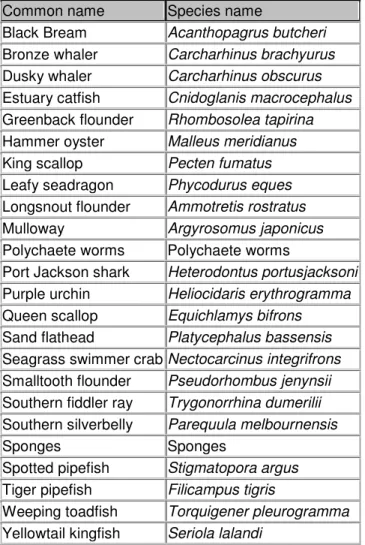
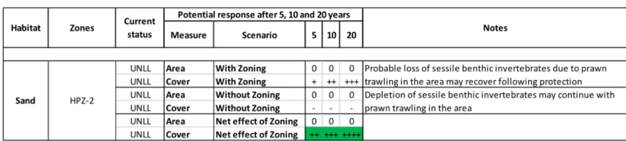
Thus, the predicted net effect of the proposed zoning, shown in Table 4-2, is a positive increase within these zones over 5, 10, and 20 years. Thus, the predicted net effect of the proposed zoning is a positive increase in size and abundance within these zones over 5, 10, and 20 year periods (Table 4-2). In addition to the species that could be assessed, there are many other species (target, by-product, by-catch) that may also respond to or benefit from the cessation of fishing within SZs (see Annex 1.3.4 of the Main Report). and which can be found in the relevant park zones (Table 4-3).
The current status of the UNLL does not necessarily mean that the exploitation of the species by fisheries is unsustainable. The current state of ecosystems in the park generally reflects the state of the component habitats and species documented above. Similarly, ecosystem responses to proposed management changes are informed by predictions for the above habitats and species.
The proposed SZ at Point Lowly (SZ-6) includes a significant amount (but not all) of the squid breeding reefs in the area.
Economic
- Commercial Fishing
- Aquaculture
- Property Prices
- Tourism
- Port, Harbour and Shipping Operations
- Mining
- Coastal Development
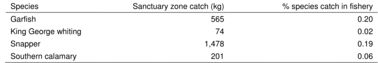
Analysis of the impact of displaced catch/effort on commercial fishing based on these industry estimates is included in the following sections. There will be no requirement for the recipients of the buyout to spend or invest the funds in the region. The total sanctuary zone catch of marine scallops represents 0.76 percent of the average annual catch in the Upper Spencer Gulf region.
This represents 0.08 percent of the Spencer Gulf Blue Crab Fishery average annual catch or 0.43 percent of the average annual catch in the Upper Spencer Gulf region. This represents 0.27 percent of the average annual effort for the charter boat industry or 12.1 percent of the average annual catch in the Upper Spencer Gulf region. Due to significant economic development expected in the Upper Spencer Gulf over the next ten years, the sanctuary and habitat protection zones of the Upper Spencer Gulf Marine Park have been declared a special purpose area, allowing specific activities.
To facilitate the movement of ships, a large body of water immediately south of the marine park will be indicated on the navigation charts for anchoring of large ships. A petroleum exploration permit has been applied for covering the southern end of the marine park, from Cowleds Landing to Weerona Island. Development plans and major projects are based on the planning strategy, which now includes the objectives of the Marine Parks Act 2007.
The declaration of the marine park network will not affect access or use of jetties, breakwaters or boat ramps.
Social
- Summary of method
- Expected social impacts – at a glance
- Education and Wellbeing
- Culture and Heritage
- Recreation and Fishing
- Local Government, Population and Housing
- Community
- SEIFA based analysis of impacts
- Next Steps in Social Impact Assessment
Nine out of 15 members6 (60 percent) of the Upper Spencer Gulf MPLAG responded to the online social impact assessment for the Upper Spencer Gulf Marine Park. DEWNR has begun a consultation process with Aboriginal stakeholders on the establishment of marine parks. The Nukunu, Kujani, Kokatha and Barngarla Aboriginal peoples are traditionally associated with the marine park areas, including the estuary and foreshore.
The Nukunu (1996) and Barngarla (1996) peoples have made Aboriginal title claims that include parts of the Upper Spencer Gulf Marine Park. The majority of MPSIAT respondents felt that the Upper Spencer Gulf community is resilient enough to adapt to the changes brought about by the proposed marine park zone (see Appendix Table 4-6). The SAMPIT and MPLAG processes provided an important opportunity for key stakeholders to contribute to the design of the marine park.
The SAMPIT and MPLAG processes provided an important opportunity for key stakeholders to contribute to the design of the marine park. Department of Environment and Natural Resources (DENR) 2010a, Environmental, Economic and Social Values of the Upper Spencer Gulf Marine Park, Department of Environment and Natural Resources, South Australia. 2010, Increasing knowledge of introduced species in Eyre Peninsula marine environments, report to the Eyre Peninsula Natural Resources Management Board.
2004, Socio-economic impact assessment of the proposed marine area for cod grounds, report prepared for the Department of Environment and Heritage, Canberra.
Socio-economic Profile – Upper Spencer Gulf
Appendix Table 1-1 Summary of key economic and social indicators for the Upper Spencer Gulf region. Population projections for the Upper Spencer Gulf region indicate that there will be little change for persons aged 0 to 14. The unemployment rate in the Upper Spencer Gulf region was 5.5 percent in the June quarter of 2011.
Employment rates in the Upper Spencer Gulf region fluctuated from 2002/2003 to 2009/2010. The total number of residents in the Upper Spencer Gulf region with a non-school diploma increased in the five years to 2006. The total number of students enrolled in primary school in the Upper Spencer Gulf region fell by 18 percent between 2001 and 2011.
The total number of students from the Upper Spencer Gulf region attending secondary school increased by 1 percent between 2001 and 2011. The average individual taxable income in the Upper Spencer Gulf region was consistently lower than the state average between 2000/01 and 2009/10. Chart 4). The Upper Spencer Gulf region's GRP comprised approximately 3.1 percent of South Africa's GSP.
Appendix Table 1-6 Components of gross regional product in the Upper Spencer Gulf region by industry, 2009/10 a.
Activities and Uses Tables
The activity is considered to be consistent with the area definition (ie no change to the current activity/use). The activity is considered to be contrary to the zoning and will not be allowed. FISHING AND GATHERING (commercial, recreational and traditional) Fishing activities are regulated under the provisions of the Fisheries Management Act 2007.
Ports, navigation and transport activities are regulated under the provisions of the Harbors and Navigation Act 1993. This will allow for (a) developments comprising a development or project, or that part of a development or project, within the scope of a declaration under section 46 of the Development Act 1993; and (b) activities that include development approved under section 49 (Crown development and public infrastructure) or section 49A (Electricity infrastructure development) of the Development Act 1993. ¹ Coastal developments and infrastructure in the HPZ will be managed under the Development Act 1993 for the purpose of definition of zone (ie no damage to habitats or ecosystem functioning).
Discharges are generally governed by the provisions of the Environmental Protection Act 1993 and the Environmental Protection (Water Quality) Policy 2003. The activity is deemed not to comply with the definition of the area and will not be considered until proven otherwise. The activity is considered inconsistent with the zone definition and will not be permitted.
Activities involving development approved under section 49 (Crown Development and Public Infrastructure) or section 49A (Electricity Infrastructure Development) of the Development Act 1993.
List of Parties Consulted
Justin Phillips Executive Officer & Industry Liaison Officer (PIFS) South Australian Rock Lobster Advisory Council, South East Professional Fishermen's Association, Northern Zone Rock Lobster Fishing Association. Emmanualle Sloan Manager, Aquaculture Planning Unit Primary Industries and Resources Division SA Sean Sloan Director of Fisheries and Aquaculture Policy Primary Industries and Regions South Australia.
MPSIAT feedback
Don't know that MP will bring too many tourists here and change the quality of our lives.
Map of Marine Park Showing Draft Zoning