Location Address 2 Daffodil Crescent, Kellyville Report prepared for The Hills Shire Council File Name 200297.00.R.001.Rev0.docx.
Introduction
Background
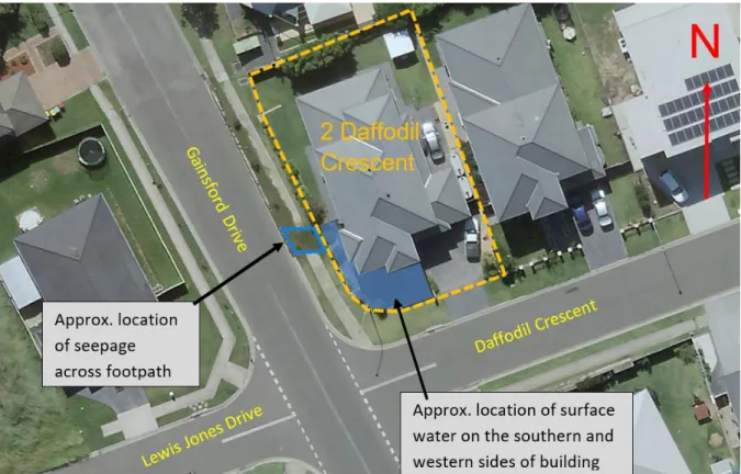
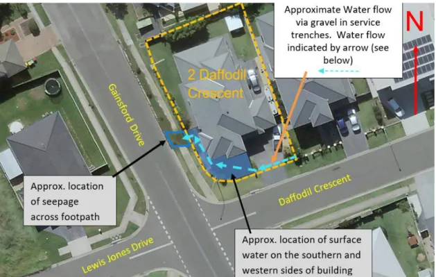
The water seepage on the west and south sides of the residence at 2 Daffodil Crescent appears to have occurred after wet weather. This seepage pattern suggests that the primary cause of the seepage is related to a water flow after rainfall (i.e. surface water, groundwater, rainwater or water from a sewage system). The water seeping over the footpath is surface water, but is considered to come from an elevated underground water source (i.e. one of the sources below).
Water from the drain line - water collected by a service trench line, which actually acts as a drain, is considered the most likely source of water seepage. The locations of the water seepage on the south and west sides of the plot are right next to existing facilities. It is suspected that this water, unable to drain efficiently from the ditch (or ditches), seeps down the slope and drains at the western end of the site, draining down onto the footpath.
Investigation will be required to determine the exact cause of the leak and provide feedback on appropriate corrective action. Once the cause of the seepage is determined, remedial measures must also consider the effect of the change in the moisture condition of the area's soils on the structural integrity of the building.
Site Description
Available Information
- Historical Aerial Photograph
- Geological Mapping
- Groundwater Information
- Existing Geotechnical Information
- Civil Drawings
- Dial Before You Dig Drawings
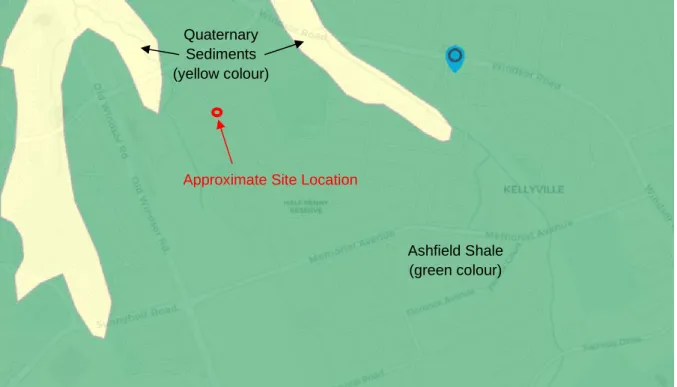
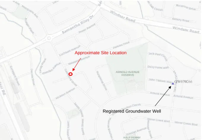
The nearest surface water receptor on the site is Elizabeth Macarthur Creek, approximately 150 m west of the site. Aquifer recharge is minimal due to the low permeability of the near-surface clay and low horizontal flow rates in the soil and bedrock. The search shows that the nearest registered groundwater bore is approx. 300 m east of the site (see Figure 3 below).
The thickness of soil generally increases with proximity to drainage lines (such as a stream). The drainage line for the intermediate lot is indicated on the property's northern border (see the attached drainage plan for the intermediate lot). The electricity network is located within the road reserve with access to the plot through the south-east corner of the plot.
Telstra lines are located in the shoulder of the road with cables running to the site through the southeast corner of the site. DP's subcontractor, Down Under Detection Services, confirmed the presence of the services listed on the DBYD plans.
Field Work Methods
Field Work Results
Laboratory Testing
Comments
The existing damaged stormwater drainage system is not considered a source of water runoff on the site. Drain line water - water flowing through the gravel in a Sydney sewer, from an improvement source (or sources), was observed in pit 3 and is considered the most likely source of water flow at property 2 Daffodil Crescent and Gainsford Street of pedestrians by car. The gravel in the Sydney Water Channel appears to be the channel for water to flow from an off-site source (or sources) and improvement.
The water then flows to the west side of the residence, where a damming effect occurs behind the retaining wall. In summary, the water appears to be coming from an upgraded off-site source (or sources) that flows onto the 2 Daffodil Crescent property via the gravel in the Sydney Waterworks ditch. A review of Council's records to assess any upgraded stormwater collection systems that could be potential sources associated with the Sydney Water sewer.
A process of eliminating potential sources along the Sydney Water sewer line is expected until the source, or sources, are determined. An interim solution involving a cut-off drainage line from an upgrade point along Daffodil Crescent on the Sydney Waterline to a drainage system could be considered.
Limitations
In any case, boreholes and test pits represent only a very small sample of the entire subsurface profile. Localized groundwater can result in a false indication of true groundwater. If this happens, the DP will be happy to review the report and the sufficiency of the investigative work.
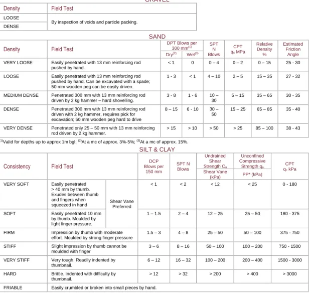
The grading system excludes the stone and cobble fractions of the soil and grades only materials smaller than 63 mm in size. A positive reaction consists in the appearance of water on the surface of the varnish, which changes to a lively consistency and becomes shiny. This strength is a measure of the character and quantity of the colloidal fraction found in the soil.
A measure of the defect's inherent surface roughness and waviness relative to its mean plane. Where sufficient UCS data is not available, the classification can be based on the point load strength (Is(50)) and refers to the strength of the rock material in the direction perpendicular to the bedding. Low Light scored with a knife; depressions 1 mm to 3 mm show in the sample with firm strokes of the pick point;.
Siltstone More than 50% of the rock consists of silt-sized (less than 0.06 mm) granular particles and the rock is not laminated. Claystone More than 50% of the rock consists of clay or sericitic material and the rock is not laminated. Shale More than 50% of the rock consists of silt or clay-sized particles and the rock is laminated.
The entire rock is discolored, usually by iron staining or bleaching to the extent that the color of the original rock is unrecognizable. Sampling is carried out during drilling or trial excavation to enable engineering examination (and laboratory testing where necessary) of the soil or rock. The abbreviated descriptions of the defects must be in the following order: Depth, Type, Orientation, Coating, Shape, Roughness and Other.
The customer should contact Endeavor Energy if any of the plans provided have blank pages as some underground asset information may be incomplete. GAINSFORD DR GAINSFORD DR GAINSFORD DR GAINSFORD DR GAINSFORD DR GAINSFORD DR GAINSFORD DR GAINSFORD DR GAINSFORD DR GAINSFORD DR GAINSFORD DR GAINSFORD DR GAINSFORD DR GAINSFORD DR GAINSFORD DRAIN GAINSFORD DRAIN GAINSFORD DRAIN GAINSFORD DRAIN SFORD DR GAINSFORD DR GAINSFORD DR LEWIS JONES DR. GAINSFORD DR GAINSFORD DR GAINSFORD DR GAINSFORD DR GAINSFORD DR GAINSFORD DR GAINSFORD DR GAINSFORD DR GAINSFORD DR GAINSFORD DR GAINSFORD DR GAINSFORD DR GAINSFORD DR GAINSFORD DR GAINSFORD DRAIN GAINSFORD DRAIN GAINSFORD DRAIN GAINSFORD DR WENDEN AVE.
GAINSFORD DR GAINSFORD DR GAINSFORD DR GAINSFORD DR GAINSFORD DR GAINSFORD DR GAINSFORD DR GAINSFORD DR GAINSFORD DR GAINSFORD DR GAINSFORD DR GAINSFORD DR GAINSFORD DR GAINSFORD DR GAINSFORD DR GAINSFORD DR GAINSFORD DR GAIN SFORD DR GAINSFORD DR GAINSFORD DR GAINSFORD DR GAINSFORD DR GAINSFORD DR GAINSFORD DR GAINSFORD DR .