i
GPS LOCATOR WITH GOOGLE MAP INTERFACE
NOORFARIZZA BT ABD MAULUD
This report is submitted in partial fulfillment of the requirements for the award of Bachelor of Electronic Engineering (Industrial Electronic)
Faculty of Electronic Engineering & Computer Engineering University Teknikal Malaysia Melaka
ii
UNIVERSTI TEKNIKAL MALAYSIA MELAKA
FAKULTI KEJURUTERAAN ELEKTRONIK DAN KEJURUTERAAN KOMPUTER
BORANG PENGESAHAN STATUS LAPORAN PROJEK SARJANA MUDA II
Tajuk Projek :
GPS Locator using Google Map Interface
Sesi :
Pengajian 2010/2011
Saya NOORFARIZZA BT ABD MAULUD
(HURUF BESAR)
mengaku membenarkan Laporan Projek Sarjana Muda ini disimpan di Perpustakaan dengan syarat-syarat kegunaan seperti berikut:
1. Laporan adalah hakmilik Universiti Teknikal Malaysia Melaka.
2. Perpustakaan dibenarkan membuat salinan untuk tujuan pengajian sahaja.
3. Perpustakaan dibenarkan membuat salinan laporan ini sebagai bahan pertukaran antara institusi pengajian tinggi.
4. Sila tandakan ( ) :
SULIT*
(Mengandungi maklumat yang berdarjah keselamatan atau kepentingan Malaysia seperti yang termaktub di dalam AKTA RAHSIA RASMI 1972)
TERHAD* (Mengandungi maklumat terhad yang telah ditentukan oleh organisasi/badan di mana penyelidikan dijalankan)
TIDAK TERHAD
Disahkan oleh:
__________________________ __________________________________
(TANDATANGAN PENULIS) (COP DAN TANDATANGAN PENYELIA)
Alamat Tetap: No.2 KAMPUNG SUNGAI SALA,RENGGOH,
73100, JOHOL, NEGERI SEMBILAN
iii
“I hereby declare that this report is the result of my own work except for quotes as cited in the references”
Signature : ………
Author : NOORFARIZZA BT ABD MAULUD
iv
I hereby declare that I have read this thesis and my opinion, it is suitable in term of scope and quality for the award of Bachelor Degree in Electronic Engineering (Electronic Industry)”
Signature :
Supervisor’s Name : MR MAZRAN BIN ESRO
v
I would to dedicate this project to my beloved mother, family and somebody
vi
ACKNOWLEDGEMENT
Alhamdulillah, most grateful to Almighty ALLAH S.W.T. for blessing me with good health and ideas in completing this project successfully.
First of all, I would like to thank to my Universiti Teknikal Malaysia, Melaka towards the great opportunity for me to have my final year project which is to be completed within a year. My foremost gratitude goes to En. Mazran B. Esro, my supervisor for the opportunity he had given to me to be a part of his students under final year project. Thanks for his precious time and helpful guidance throughout the year. Honestly, it is the most valuable chance for me to explore and expose myself to the real engineering fields which needs me to be equal in knowledge, skills and managements.
I would also like to thank Mr Adha Hanif, my Engineer during internship program for the support and assistance that been given, especially the exposure of Visual Basic theory, practical and it application to this project.
Besides, lots of love for my family for their continuous supports especially my mother and Mr.Asraf B. Md. Shah. To my siblings who are always stand by my side to encourage, advice and support during this entire project.
vii
ABSTRACT
viii
ABSTRAK
Projek ini bertujuan membangunkan sebuah ruang hubung kait Global
Positioning System (GPS) Pengesan Tempat menggunakan Google Map. Ruang
Hubung kait membolehkan pengguna melihat dan mengetahui maklumat mengenai
GPS dan dibantu oleh paparan dari Google Map. Ruang Hubung kait ini akan
dibangunkan menggunakan program Visual Basic (VB), yang di kombinasikan dengan aplikasi Web Google Map. Ruang hubung kait ini akan memaparkan lokasi menggunakan Google Map yang di kehendaki oleh GPS Pengesan Tempat dengan memasukkan koordinat dari sistem Modem GSM (Global System for Mobile
Communication) . Modem GSM akan digunakan untuk menerima data dari
mana-mana GPS. Modem GSM ini akan disambungkan ke komputer dan data koordinat akan diproses menggunakan Visual Basic dan memaparkan peta untuk lokasi tersebut mengikut koordinat.Selain GSM, Litar MikroPengawal PIC (Peripheral Interface Circuit) juga turut digunakan untuk menghantar data koordinat, ini
ix
TABLE OF CONTENTS
CHAPTER TITLE PAGE
PROJECT TITLE I
DECLARATION III
SUPERVISOR AUTHENTICATION IV
DEDICATION V
ACKNOWLEDGEMENT VI
ABSTRACT VII
ABSTRAK VIII
TABLE OF CONTENTS IX
LIST OF TABLES XII
LIST OF FIGURES XIII
LIST OF ABREVIATIONS XV
LIST OF APPENDICES XVII
I INTRODUCTION
1.1 BACKGROUND: 1
1.2 OBJECTIVES: 2
1.3 SCOPE: 3
1.4 PROBLEM STATEMENT: 3
1.5 METHODOLOGY: 4
x
II LITERATURE REVIEW 9
2.1 TECHNIQUE 1: C# PROGRAMMING LANGUAGE 9
2.1.1. BACKGROUND: 10
2.1.2. COMPARISON: 10
2.1.4 ADVANTAGES OF BOTH VB AND C#: 11
2.1.5 DISADVANTAGE: 12
2.1.6 ELEMENT ANALYSIS: 12
2.2. TECHNIQUE 2: WEBGIS BASED ON ARCGIS. 14
2.2.1 BACKGROUND: 14
2.2.2 COMPARISON: 15
2.2.3. ADVANTAGES AND DISADVANTAGES: 15
2.2.4. ELEMENT ANALYSIS: 16
2.3. TECHNIQUE 3: FLEX APPLICATION 17
2.3.1 BACKGROUND: 17
2.3.2. COMPARISON: 18
2.3.3 ADVANTAGES AND DISADVANTAGES: 18
2.3.4. ELEMENT ANALYSIS: 21
III METHODOLOGY 22
3.1. FLOW CHART: 22
3.1.1. PROJECT BLOCK DIAGRAM 23
3.1.2. PHASES OF THE PROJECT: 23
3.1.3. FLOW CHART 25
3.2. PROJECT DEVELOPMENT WITH GSM MODEM
29
3.2.1. HARDWARE 29
xi
3.3. PROJECT DEVELOPMENT USING PIC
MICROCONTROLLER 35
3.3.1. HARDWARE DEVELOPMENT 35
3.3.2. SOFTWARE DEVELOPMENT 40
IV RESULT & DISCUSSION 46
4.1.1. FINDINGS OF METHOD 1: GSM MODEM 47 4.1.2 FINDINGS METHOD 2: PIC CIRCUIT 53
V CONCLUSION & SUGGESTION 55
5.1 CONCLUSION: 55
5.2 SUGESSTION: 56
REFERENCES: 57
xii
LIST OF TABLES
NO TITLE PAGE
2.1 Advantages of VB & C# 11
xiii
LIST OF FIGURES
NO TITLE PAGE
1.1 Phase of the Project 5
2.1 Interface of the application client 20
3.1 Project Block Diagram 23
3.1.1 Flow Chart of the Project using GSM Mode 25 3.1.2 Flow Chart of the Project using PIC Circuit 26
3.2 GPS Locator Interface Development 29
3.2.1 GSM Modem 30
3.2.2 RS232 30
3.2.3 USB Serial Cable 31
3.2.4 Illustrate of GPS Locator using Google Map Development 32
3.2.5 Visual Basic Development 34
3.2.6 GPS Locator Interface 34
3.3 GPS Locator Interface Development 35
3.3.1 PIC 16F877A 36
3.3.2 RS232 Connection with PC 37
3.3.3 MAX232 38
3.3.4 Crystal Oscillator 38
3.3.5 SMD Resistor 39
3.3.6 Power Supply 39
3.3.7 Compiler Program 40
3.3.8 PIC Burner 41
3.3.9 PIC kit 2 Programmer 42
xiv
3.4.1 Program Failed 43
3.4.2 PIC Microcontroller Board 44
3.4.3 Illustration of Development 44
3.4.4 DB9 Connector 45
3.4.5 Connection to PIC Circuit 45
4.1 Visual Basic String to Web Browser 47
4.1.1 Visual Basic Program 48
4.1.2 Interface with Google Map 48
4.1.3 SMS Receive to Interface 50
4.1.4 Select the Location 51
4.1.5 AUTO UPDATE Location 52
4.2 Data sending to the Interface 53
4.2.1 Select the Location 54
xv
LIST OF ABREVIATIONS
API - Application Programming Interface AT Command - Attention Command
CTS - Clear to Send
DCE - Data Communication Equipment DTE - Data Transfer Equipment
GIS - Geographic Information System
GND - Ground
GM - Google Map
GPS - Global Positioning System GSM - Global System for Mobile GUI - Graphic User Interface HEX - Hexadecimal
IDE - Integrated Development Environment JAVA - programming language
LINQ - Language-Integrated Query
LOC - Location
MXD - Map file (ArcInfo) PC - Personal Computer
PIC - Peripheral Interface Circuit RIA - Rich Internet Application RTS - Request to Send
RX - Receiver
xvi
T-SQL - Transact Structured Query Language
TX - Transmitter
URL - Uniform Resource Locator USB - Universal Serial Bus
VB - Visual Basic
xvii
LIST OF APPENDICES
NO TITLE PAGE
A AT Command 59
B MOD 9001D RS232 GSM/GPRS Modem 60
C1 Visual Basic Coding 61
1
CHAPTER I
INTRODUCTION
This chapter explains about the introduction to the project, problem statement, objectives and scope of the work for the project. It also has some explanation about the methodology that is used for this project.
1.1 Background:
2
is used to transmit these location data between users and the monitoring centre. Thus the PIC also follows this same format. The latitude and longitude information will then be processed and fed into Google Map using Visual Basic. Based on this system and the technology for encapsulating and parsing VB data is utilized for Google Earth to display the detailed geographical information on the screen [6]. The integration between the hardware and software will successfully displayed the user interface for mapping and positioning system.
1.2 Objectives:
Main objective of this project is to provide user interface on PC for GPS Locator System. Among the task include:
1.2.1. To receive and pass the processed GPS data from transmitting module to PC through RS232 communication
1.2.2. To extract the data from GSM Modem or PIC Circuit using appropriate AT Command
3
1.3 Scope:
This project required to provide the user interface based on window desktop application to enable the data input from transmitting module to display the map of the location according to the GPS data elsewhere. The GSM modem or PIC Circuit will take responsibility to receive the data and pass the information to PC through RS232 communication. This GSM Modem is supporting AT command and will be set to receive SMS using Hyper Terminal for its Module Connection, while for the PIC Circuit the data of each location will be stored in the PIC program and still use this same command to display the data in the interface. The main function of this command is, to extract the data from GSM Modem or PIC Circuit to the Visual Basic application and display the Google Map. The Visual Basic will establish the interface between PC (Google Map) and the user. In order to implement this task, it is required to add mapping to a windows desktop application (with an available internet connection) using Google Maps as the basis and source for the map. This application contains one form that controls and code necessary to request and display a map from the Google Maps site
1.4 Problem Statement:
4
1.5 Methodology:
In order to achieve the objectives of this project, it will go through the several phases, which are:
Start of Project
Discuss with the Supervisor
Literature Review
Prepare Milestone schedule
Develop the GUI using VB Setting the GSM to Receive SMS (At Command)
Integrate the GSM Modem with GUI
Phase 1- July 2010
Phase 1- July 2010
Phase 2- July 2010
Phase 2- August 2010
Phase 3- August 2010
Phase 4 - September 2010
5
Figure 1.1 Phase of the Project
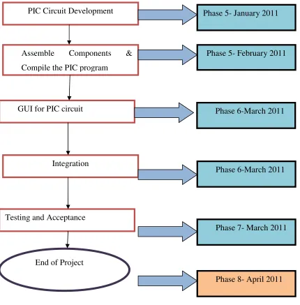
PIC Circuit Development
Assemble Components & Compile the PIC program
GUI for PIC circuit
Integration
Testing and Acceptance
End of Project
Phase 5- January 2011
Phase 7- March 2011 Phase 6-March 2011 Phase 6-March 2011 Phase 5- February 2011
6
Phase1:-Discuss with supervisor Mr Mazran Esro and present the project
progress or finding. Then, research further information about the title of the project, collect the information about GSM modem, GUI that will be used (Visual Basic Express Edition) from supervisor, retrieved from website, books, IEEE journal, thesis, and so on. Try to understand the concept & desired result for this project. After that, obtain the datasheet of component involved such as GSM Modem, PIC microcontroller, voltage regulator, Oscillator and other
Phase2:- For this phase, survey of the entire previous GPS Locator project is
done to find the best method and approach for the project. Literature survey from journal and internet is carried out. The comparison method of GUI is performed in order to enlist the best technique to be implementing in this project.
Phase3:- For this phase, the information about the GSM that will be used is
collected. Studied on how to receive SMS using AT command (Hayes command set (also called the AT commands: "AT" meaning attention).)
Phase4:- In this phase, the GUI using Visual Basic Express Edition is prepared
to interface Google Maps. Next, the GSM Modem is integrated with the VB, to interpret the data from SMS to the VB and display the map using Google Maps
Phase5:- The PIC circuit is developed, to implement the different method to
send data using PIC circuit and interface using Google Maps. The circuit design that prepared by supervisor is used, next the component is assembled and alteration on program that been given is implemented to meet the requirement of the project. It is exactly the same function as sending SMS, but for this time, the PIC circuit to is used to generate the data.
Phase6:- In this phase, the VB is prepared to accept the data from PIC. The
same process as use in the previous method (SMS) been implemented. Next, the both development are integrated and the performance been tested.
Phase7:- For this phase, the software part is combined with hardware part to
7
that the functionality, ability & weakness of circuit design and software test are studied, next the conclusion based on the findings is prepared.
Phase 8:- Lastly, to complete and fulfill the procedure for the PSM, complete the report for this project. This report will explain about the project in details.
1.6 Report Structure:
The report structure is about the flow of the project. This report is having five chapters which included introduction, literature review, research methodology, result and discussion, conclusion and suggestion.
First chapter will discuss about the GPS Locator using Google map interface overview and introduction. Next the objective, problem statement, scope of work, and project methodology are discussed briefly which purposely to provide the reader an understanding of the project. The introduction of the project starts with the explanation about the significance of the project and from perspectives of previous researches that been done.
Chapter II is embracing the literature review of the project which includes the concept, theory, perspective and the method of the Visual Basic and C# that is used in order to provide the Graphic User Interface (GUI) any hypothesis that related with the developing of methodology. The overall literature review will produce the conceptual framework to present the relationship between project research with theory and concept through figures or corresponding model.
Chapter III will explain about the project methodology. This chapter will discuss the method or approach that has been used in project development and problem solving, including in hardware and software aspect such as, GSM Modem Communication and PIC Microcontroller Board.
Chapter IV presents the findings and discussion of the project. It also discusses briefly on the observation, results and the analysis of the project that gain during the development of project. This chapter also consists of the recorded data analysis and the result of the project.