Lセ MMM NNNMM MMMMMMMMMM ..M セM MNセM ..
Geospatial
and Human-Dimensions
on Natura l Resource
Proceeding:
Geospatial and HumanDimensions
on Natural Resource Management
ISBN 9786021443705
Pusat PengkaJlan Perencanaan dan Pengcmbangan Wilayah (P4W) Center for Regional System Analysis Planning & Development (Crestpent) Bogar Agricultural University (lPB)
Editor
Dr. Ir. Ernan Rustiadi, M.Agr
Dr. Ir. Saba Baru s, MSc
Dr. Satyawan Sunilo
Copy Editor
Galuh Syahbana Ind raprahast a
Febri Sasliviani Puln Canlika
Layout & Cov er De s ign er
Jam.:.aiS':"2
Cres.!pent Press
セ セS@ 3<oana ngsiang . JI. Raya Pajajaran, Bogor 16 144, ...aKa 3arat. IneCHeSJ8 Phone/Fax: 025 1 8359072
Creslpent@2013
Geospat:iat and Human Dimensions
II
on Natural Resou rce Manage me nt(i
"
')
I,
Th
'"
Eo
"t th'
Thi:
sep.
with
SOUl
the <
"tw
Sl(PO
dala,
ph(l!o
problE
aid de
On be
ediror!
Spatial Multi Criteria Analysis for Determining Paddy Field
Availability in Cianjur Regency, West Java, Indonesia.
D, Shiddlql. ILH Sunsun Saefnlh (lkl lll
t,and
セN@Banr::;l2
I Center lor Regional Sy;tem Ana lysis, Planning and Develop ment, Bogor Agri cultural Universi ty. Jalan Pajajaran. Bogor 16144.
I De partm ent of Soi l Scien ce and land Resources, Bogor Agricultu ra l University. Jalan Merantt
Darmaga, SOgar 16580.
Emai l: sh idd [email protected], phone/fax: I622S18359072
N | セ ウ ョ ャ|ct@
Recen tl v. food security become an issu e in Indonesia, espeCially OIl paddy fields . Some paddy
fie ld,s are being proposed to be protected by laws, expanded, or allocated fOt par ticular farm ers. How ever, selecting and proposing paddy field s based on spatial multicriteria an alyses have be en
an Intricate tasks, t herefore require a particu1at method, which is nOt ava ilable at present orne In
Indo nesia. Recent methodologica l analysis on agri cultu ral land availability has been conside ring
phySical or socio·eco nomic aspects. however t hi s would not ensure proper accountin g of actu
-al ag ricultura l land ulililanon. The research was aimed \0 com pare Boolean Combinalion and
Weight ed Linear cッ ュ「ゥョ 。セッ ョ@ analysis meth ods to det ermine pad dy field ava il ability; to defin e
spa-tial reJafionship between ーィケセ 」。ャL@ ec.onomic. and legal aSpects as 'Nell as sustainability related to det ermin ing agri cultu ral land ava ilability; and to calculate paddy fie ld avaitability. tn thiS resea rch .
add itiona l aspects such as land al lOCati on policies and erOSion levels, were employed a nd se rved as
sup plement ary variables in agr iculw ralland ava ilability 。 ョ 。 ャケウゥ ウNエセ・イ・ ヲッイ ・@ minimize possibili ty on confli cti ng land uti lization and ensure agricul tural sustainability. Spatial an alysis using Ge ograp hical
Information System coupled wi th Multicriteria EvaluanOtl was em ployed to investigate avail able
lands based on previous criteria. Specifically.
a
Weight ed li ne ar Comb ination (WLC) was assessed to provid e dynamiC vari ation s of we ig ht and adaptive to di ffer effect of each va ria ble . weightingby me ans of Analytic Hie rarchy Proce$s (A HP) showed that ,he physical faaofs (i.e. land suitabilily) achi eved th e highest rank (about 16.7%), while the lowest wa s land utili2 atlo n (6. 3%J. Analys is of Wl C suggested that th ere are about 136,549 Ha available fOf paddy field whi le calculation using Boolean Combination obta ine d 30, 590 ha availab le for paddy field. In th
e context of decisionmak-ing the Boolean metho d tends to ta ke risks in ma ki ng decisions while th e WlC methOd shares the risk in decisionmaking starts th e towest 10 the highe$\ at risk_
Keywords: Land suitability, Spatial An alysis. Mul!i Criteria Evaluation, Weighted Linea r Combination
•
370
Introduction
Rece ntly, food security become an issue in Indonesia, especially on paddy fie lds. Some
paddy fie lds are being proposed to be protecte d
bylaws, expanded, or allocated for
particu lar farme rs. However, selecti ng and proposing paddy field s based on spatia l,
multicriteri a analyses have been an intricate ta sks, therefore require a particular method,
which is not available at present time in Indo nesia. Recent methodologica l analysis on
agricultural land availability has been considering physical or socioeconomic aspects,
however this would not ensure proper accounting of actual agricultural land utilization.
The research was aimed to compare Boolean Combination and Weighted linear
Combination analysis met hods to determine paddy fie ld availability; to define spatia l
relationship between physical. economic, and legal aspects as well as sustainability re lated
to determining agricultural land ava ilability; and to calculate paddy fiel d availabil ity. In
th is re search, additional aspects such as land allocation policies and erosio n levels, were
employed and served as supplementary variables in agricultura l land ava ilability ana lysi s,
th erefore minimize possibility
on
conflicti ng land utilization and ensu re Cl gricu ltural sustainability. Spatial analysis using Geographical Informa ti on System coupled with M ul(l·criteria Evaluation was employed to investigate available lands based o n previous aiter!;; .
Specifically, a Weighted linear Combinati on (W l C) was assessed to provide dynam·: variations of weight and adaptive to different effect of each variable
Methodology
Location and time
location of the research was Cianj ur District. Analysis was conducte d at StudIO of Reg y.
System Analysis, Crespent IPS at 2010; Field observation waS conducted in feb J May 2010.
Method
Paddy held availabi lity defi ne as proper ((iterias in physica l, socioeco nom < .
.='"
factors that minimized conflict and ensure agricultural sustai nability.
Multicriteria Evaluation (MCE) analySiS was choic ed t o determ ined paddy ne!:: セNL@
GeneraUy, a Multicriteri a ana lysis is defined as "a decisionaid and m
olrf"-allOWing the comparison of different alternatives o
r scenarios, often conf ::-to many crileria in o rder to guide toe decision maker (Roy
in.
Chakkar and :.':.I
ゥNj@Spatial m ulticriteria is an apllication of multicriteria that has explicir spatial dimensions.
Two krnd methods of MCE was used. the first method is boolean combination and the
remaining is Weigh ted Linear Combination (WLCj .
MCE fra mework consist of goals and criterias detemination.The crit eria are divided to
fact ors and constrai nts. Facl ors aTe alte rnatives or criterias that support t o reac h the goal,
where in con trast the cons traints are alternatives o r criterias that contrain the goal.
Based o n this MCE framewor k, th e
goal
was defined as Paddy fie ld availability Map. Threefactors were choiced, (1) Phyisical Factors, ie. land suitabil ity, accesibility to water sources,
erosion level; (Z) Sociaeconomic (actors, i.e. land utilization. accessi bility to market plac e;
accessilibility to road; (3) l egal Factors, i .e. regional land allocation policy (RTRW), forest
la nd allocation policy, and estate land allocation policy.
Evaluation Criteria
In Boolean Combination method. aU a il eria (factors and contraints) Wefe standardized to
boolean value (O/nonsuitable and 1/suitable). and method of agregalion in GIS melhod
was boolean intersection (multiplication criteria). where in contrast WLC method,
fac-lars and conlraints were determined to degree of
suitability for all areas
(05)
(Eastman,2006).
Thehigher value indicate the higher suitability. Following
mathematical equation des.cribed the Agregalion of
WLC methods.
Where: WlC = weighted linear combination,
X=degree of suitability factor/Sub -fa clor,
W=weighted factor/Sub -factor, C= Const raint,
セ G@
"
. 1
i=numbero/focto",j=/ocoHon
+_
..
セZ BG@
Weigh t ed Factor determined by an"lytical hierarc hyprocess (AHP) method (Saaly, 1994).
Result
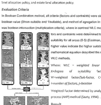
Figure 1 showed spatial allocation resulting from
Boolean Combinati on and Wl C methods. Boolean
combination method suggested tight area th at
available fo r paddy field whi le Wl C method obtai ned
Figure 1. WLC M3p
[image:5.613.42.398.269.638.2]I
more areas. Green areas indicate paddy field availability mostly found at northern CianJur
Regency which has the form of
nat
land and adjacent to center activity (fig. 1.a). In theWLC method, the paddy field availability of class is divided into 5 classes as indicated by
different colors in the Map (fig. l.b). Color maps were Increasingly red color indicates the
va lue of the lower grade of availability. The red color on the map found in areas that have
[image:6.611.47.406.157.322.2]hilly and mountainous landform with steep slopes.
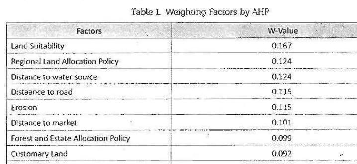
Table l Weighting Factors by AHP
Factors w M v 。ャオセ@
セ@
,
I
Land Suitability 0.167 t
-r・ァゥ_セセ⦅ i ⦅セセセAャiッcSエゥッョ@ PoI =' iCY _ _ _
__1
'" ___,.. , ..
__
セZZセセLN__._
0.124
Oi,taance to road 0.115
I
Erosion 0.115
I
, Oistance to ュBイセ・ャ@ 0.101
MMMMN MMMZMセ@
... L
,
セセZセセセセセ⦅
e⦅ G B B セセo セ 」 o 」 o 」 BMM
⦅⦅ ⦅
]」 B B 」 p c iゥcy
___
' f :_ _ _ _ _ 0.09'3 ___ Jセ。 」ッZ 、
M
_ _
セセセセ_セセセセ
] ] MMMMMMMM
MMQi MM M M MMMMMMLMMセセᄋMMZセセセセ
M ⦅@
Total 1.000
Weighting by means of Analytic Hierarchy Process (AHP) showed that physical factors (i.e.
land suit",bility) achieved highest rank (about 16.7%), while the lowest was land utilization
(6.3%).
Analysis ofWLC suggested that there are about 136,549 Ha available for paddy field while
calculation using Boolean Combination obtained 30,590 ha available for paddy field.
Conclusion
In the context of decisionmaking. boolean methods tend to take risks in making decisions
while the
WlCmethods share the risk in decisionmaking starts the lowest to the most at
risk.
References
Chakkar, S dan V. Mousseau, 2007. Spatial Multi Criteria Decision Making. LAMSADE. University of Paris Dauphine, France
Saaty. T.L. 1994. Fundamentals of analytic hierarchy process. RWS Publication. Pittsburgh, USA.
Eastmen, J.R. 2006.ldrisi Andes Guide to GIS and Image Processing. Clark LabClark University.
Geospatial and Human Dimensions
Hosted by P4W/CRESTPENT, Bogor Agricultural University
in collaboration with lAPAN, BAKOSURTANAL, MAPIN,
STPN, )KPP and supported by Faculty of Human
Ecology-IPS, Forum Tata Ruang, Common Indonesia Forum, HOP
Indonesia, and SLUAS JSPS Project, the 2011 International
Seminar on Geomatics & SAR (GeoSARNas) and Human
Dimensions on Sustainable Natural Resource Management
was successfully held at IPB International Convention Center,
International research communities
and
practitioners works
on
land and natural resource Issues communicating their recent
Crcstpont Press
Kampus
IPB
Baranal19siang. JI. Raya Pajajaran.Bogot-16144 . Jawa Bara\, Indonesia
PhoneIFax: 0251 8359072
E-MaiI;[email protected]