AGRIVITA Journal of Agricultural Science. 2016. 38(2): 105-115
SPATIAL MULTI-CRITERIA DECISION MAKING FOR DELINEATING AGRICULTURAL
LAND IN JAKARTA METROPOLITAN AREA
’S HINTERLAND: CASE STUDY
OF BOGOR REGENCY, WEST JAVA
Widiatmaka 1*), Wiwin Ambarwulan 2) and Sudarsono 1)
1) Department of Soil Science and Land Resources, Bogor Agricultural University, Indonesia 2) Geospatial Information Agency, Indonesia
*) Corresponding author E-mail: [email protected]; [email protected]
Received: December 6, 2015/ Accepted: March 16, 2016
ABSTRACT
The hinterland of Jakarta has experienced high pressure in its land utilization due to Jakarta’s rapid development. The objective of this research was to analyse the suitable land available for agriculture. The research was conducted in Bogor, a hinterland regency of Jakarta. The methodology used includes two steps of analysis, which are land suitability and land availability analysis. Land suitability for agriculture was analysed using multi-criteria decision making method. Seven (7) criteria were included, which consist of soil class, land capability class, slope, elevation, slope aspect, land use/land cover and distance to roads. The criteria were weighted using the Analytical Hierarchy Process. Combining criteria weights and sub-criteria scores, an overlay model in Geographic Information System was applied. The result from land suitability analysis was used as a feed for determining land availability, considering the forest area status and land allocation in the official spatial land use plan. The results indicate that an area amounting to 87.5% of Bogor Regency is suitable for agriculture. Land which is suitable and available for agriculture is 16.7% of the regency’s area. Considering available land which is currently in use, the area that can be allocated for the expansion of agriculture is 3.3%. Keywords: land availability; land capability; land suitability; land use planning; soil order
INTRODUCTION
The state capital of Indonesia, Jakarta, has been developing very rapidly to become the second largest metropolitan area in the world after Tokyo (Fukami et al., 2014; Pravitasari et al., 2015). Data on the period from 1972 until 2010,
for example, indicated that the urban area of Jakarta and its surroundings, namely the Jakarta-Bogor-Depok-Tangerang-Bekasi (Jabodetabek) region had increased by more than 2,096 km2, as a result of urbanization process (Rustiadi et al., 2013; Pravitasari et al., 2015). The pace of development of Jakarta has induced rapid land use changes in the surrounding area. The surrounding region, which was an agricultural region with regencies such as Tangerang, Bekasi and Bogor forming the agricultural hinterland, has experienced the pressure of Jakarta’s development through the development of urban areas that are often random sprawl (Hidajat et al., 2013). One of the implications is the increase of the industrial, residential and built area as well as the decrease in agricultural land. Statistical data shows that despite the extent of paddy field in Bogor which was relatively constant at around 47,500 ha, dry land agriculture has been reduced from 142,764 ha in 2002 (Statistics West Java, 2003) to 127,369 ha in 2013 (Statistics West Java, 2014, data processed). In the same period, yards, buildings and built area in Bogor Regency has increased from 37,020 ha (Statistics West Java, 2003) to 92,294 ha (Statistics West Java, 2014, data processed).
Such situation indicates the high pressure on land utilization in Bogor Regency, including on agricultural land. Similar phenomena seem also to have occurred in the hinterland of other metropolitan cities on the island of Java, an island which makes up only 7% of the land area of Indonesia (Statistics Indonesia, 2014a), but is inhabited by more than 50% of Indonesia's population (Statistics Indonesia, 2014a). In fact, in current conditions and at least for the next few years, Indonesian agriculture will still be highly dependent on the availability of land in Java Island, given that agricultural development outside of
Cite this as: Widiatmaka, W. Ambarwulan and Sudarsono. 2016. Spatial multi-criteria decision making for delineating agricultural land in Jakarta metropolitan area’s hinterland: Case study of Bogor Regency, West Java. AGRIVITA Journal of Agricultural Science. 38(2): 105-115. Doi: 10.17503/agrivita.v38i2.746
Accredited : SK No. 81/DIKTI/Kep/2011
Java Island is relatively slow (Widiatmaka et al., 2015a).
Addressing the increasing pressure on agricultural land, one of the measures that can be taken - other than finding alternative agricultural land outside the island of Java - is using agricultural land available on Java Island in a more efficient way. This is unavoidable, given that the actual base of food production, and this is true both in the immediate short to medium term and in the future, will remain on Java Island. To illustrate the situation, in 2013, 52% of the domestic paddy yield as well as 53% of corn, 65% of soybean and 70% of green bean came from Java Island (Statistics Indonesia, 2014b, data processed). One of the questions which can be raised is there-fore, how much area can actually still be used for agriculture? Which areas of land should be used in a more efficient way? This research was conducted in Bogor Regency and analysed the situation in its local conditions.
One way to improve land utilization effi-ciency in agriculture is by using land with high suitability for agriculture. More detailed analysis for specific commodities can then be carried out afterwards. Land evaluation is the first step towards land use planning (Kabanda, 2015; Widi-atmaka et al., 2014a, b), with the aim of delineating land at various levels of suitability.
Since the introduction of the FAO’s land evaluation concept in 1976’s that considers phys-ical, social and economic aspects of land resources (Akinci et al., 2013; Widiatmaka et al., 2015b), this concept has been developed rapidly. Various tools have been developed for analysis (Mendas and Delali, 2012; Elsheikh et al., 2013; Akinci et al., 2013). Recently, land evaluation has been integrated with soft system methodology for decision making, known as multi criteria decision making (MCDM). Tools for decision-making, among others the Analytical Hierarchy Process (AHP) (Saaty, 2008) and the Analytical Network Process (ANP) (Saaty and Vargas, 2013; Aragonés-Beltrán et al., 2014; Zabihi et al., 2015) can be integrated with land suitability evaluation. This development is supported by the rapid development in remote sensing and geographic information systems (Malczewski, 2006). This has allowed the land evaluation method to be achieved through the decision-making concept
utilizing several criteria which can be done spatially. The concept is not only useful for agriculture (Baja et al., 2007; Bandhyopadhyay et al., 2009), but also used for other sectors including forestry (Segura et al., 2014), industry (Rikalovic et al., 2014), tourism (Rozman et al., 2009), landfill site (Guiqin et al., 2009; Effat and Hegazy, 2012), parking site (Zucca et al., 2008) and environment (Comino et al., 2014).
Apart from carrying out analysis to select suitable land, land availability also needs to be analysed in view of the need for land by other sectors. In the Indonesian context, the forest area has been formally defined in the Forest Area Status (FAS) map, where the use of land for farming can only be undertaken in land outside the forest area, defined as “area for other utiliza -tion” (AOU) (Ministry of Forestry, 2009). This regulation was intended to maintain the sustain-ability of forest cover for ecosystem sustainsustain-ability (Kusmana, 2011). Land allocation was also formally arranged through formal allocation by the Official Spatial Land Use Plan (OSLUP) (Government of Indonesia, 2007), where land was allocated for many sectors. Consideration of such regulations can be achieved through the integrated analysis of land suitability and land availability (Widiatmaka et al., 2015b). In such a manner, land use planning for agriculture can be achieved in the context of land utilization for other sectors. Selection of land through the integration of land suitability and land availability will also be useful in keeping land utilization sustainable. The objective of this re-search was, therefore, to delineate land suitability for agriculture and then to delineate such suitable land which was also available for agriculture.
MATERIALS AND METHODS
Study Area
Widiatmaka et al.: Spatial Multi-Criteria Decision Making for Delineating Agricultural Land in Jakarta...
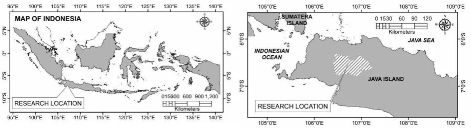
Figure 1. Research area of Bogor Regency, West Java The average annual rainfall is 3,992.7 mm.
The wettest month is January, with an average monthly rainfall of 509.2 mm, while the driest month is June, with an average monthly rainfall of 62.3 mm. The average air temperature in 2013 ranged from 25.1° C to 26.4° C. The hottest air temperature occurred in June, amounting to 34.7° C, while the coldest was in December at 19.0°C. The landforms of the region are diverse, predom-inantly flat in the north part, while the southern part is dominated by undulating to mountainous landforms (Statistics Bogor Regency, 2014). Data
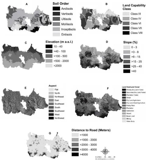
The spatial data of soil class are compiled from the results of previous soil survey mapping which include the area of Bogor Regency: soil mapping at the area around Bogor by Soil Research Institute, soil mapping at Jabotabek area by the Center for Soil Research, and soil mapping at Upper Cisadane Watershed by the Center for Soil and Agroclimate Research. They were compiled by Widiatmaka et al., (2015c) as soil map at a scale of 1:50,000. Although on the original map, soil was classified in more detailed classification, in this research soil class was presented in soil order category only (Soil Survey Staff, 2014). Data from these previous studies were also used in this study for the creation of a land capability map according to the criteria of Soil Conservation Service, United States Depart-ment of Agriculture (Fenton, 2006; Singer, 2006).
Topographic maps from the Indonesian Geospatial Information Agency at a scale of 1:25,000 were used for the creation of spatial data on elevation, slope and slope aspect using the spatial module of ArcGIS 10.2 (Widiatmaka et al.,
2015c). The data on the distance from the road were created by buffering the 1st and 2nd order road on such topographical maps. The actual land utilization was interpreted from Landsat OLI of 2013, interpreted in this research by supervised classification using ERDAS Imagine software (Widiatmaka et al., 2015c). The Indonesian standard imagery classification (SNI, 2010) was used. Field checking was done in August 2015. Analysis
Figure 2. Spatial distribution of: A. soil order1,; B. land capability class1, C. elevation2,3, D. slope2,3; E. slope aspect2,3, F. land use and land cover2,4, G. distance from road2,3. Data sources and reference: 1) Compiled and processed by Widiatmaka et al. (2015c) from previous soil survey and mapping which include Bogor Regency; 2) Widiatmaka et al. (2015c); 3) Spatial treatment from Geospatial Information Agency’s topographic map of 1:25,000; 4 ) interpreted from Landsat OLI of 2013
A B
C D
E F
Widiatmaka et al.: Spatial Multi-Criteria Decision Making for Delineating Agricultural Land in Jakarta...
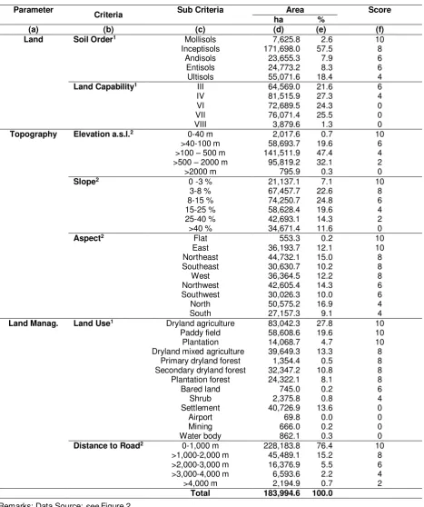
Table 1. Distributions of the criteria, and sub-criteria in the study area
Parameter
Criteria Sub Criteria Area Score ha %
(a) (b) (c) (d) (e) (f)
Land Soil Order1 Mollisols 7,625.8 2.6 10 Inceptisols 171,698.0 57.5 8
Andisols 23,655.3 7.9 6 Entisols 24,773.2 8.3 6 Ultisols 55,071.6 18.4 4
Land Capability1 III 64,569.0 21.6 6
IV 81,515.9 27.3 4
VI 72,689.5 24.3 0
VII 76,071.4 25.5 0
VIII 3,879.6 1.3 0
Topography Elevation a.s.l.2 0-40 m 2,017.6 0.7 10 >40-100 m 58,693.7 19.6 6 >100 – 500 m 141,511.9 47.4 4 >500 – 2000 m 95,819.2 32.1 2 >2000 m 795.9 0.3 0
Slope2 0 -3 % 21,137.1 7.1 10
3-8 % 67,457.7 22.6 8
8-15 % 74,250.7 24.8 6 15-25 % 58,628.4 19.6 4 25-40 % 42,693.1 14.3 2 >40 % 34,671.4 11.6 0
Aspect2 Flat 553.3 0.2 10
East 36,193.7 12.1 10
Northeast 44,732.1 15.0 8 Southeast 30,630.7 10.2 8
West 36,364.5 12.2 8
Northwest 42,605.4 14.3 6 Southwest 30,026.3 10.0 6
North 50,575.2 16.9 4
South 27,157.3 9.1 4
Land Manag. Land Use1 Dryland agriculture 83,042.3 27.8 10 Paddy field 58,608.6 19.6 10 Plantation 14,068.7 4.7 10 Dryland mixed agriculture 39,649.3 13.3 8
Primary dryland forest 1,354.4 0.5 8 Secondary dryland forest 32,347.2 10.8 8 Plantation forest 24,322.1 8.1 8
Bared land 745.0 0.2 6
Shrub 2,375.8 0.8 4
Settlement 40,726.9 13.6 0
Airport 69.8 0.0 0
Mining 666.0 0.2 0
Water body 862.1 0.3 0
Distance to Road2 0-1,000 m 228,183.8 76.4 10 >1,000-2,000 m 45,489.1 15.2 8 >2,000-3,000 m 16,376.9 5.5 6 >3,000-4,000 m 6,593.6 2.2 4 >4,000 m 2,194.9 0.7 2
Total 183,994.6 100.0
Table 2. Rating for pairwise comparison according to Saaty (2008)
1/9 1/7 1/5 1/3 1 3 5 7 9
Extremely Very strongly
Strongly Moderately
Equally
Moderately Strongly Very strongly
Extremely
Less important More important
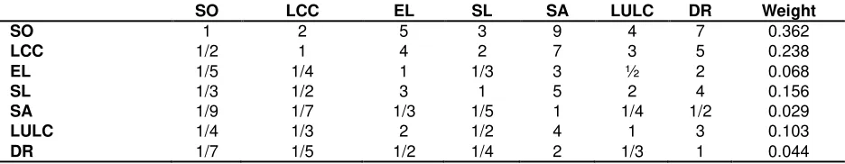
Table 3. Weight of parameter resulting from pairwise comparison of criteria
SO LCC EL SL SA LULC DR Weight
SO 1 2 5 3 9 4 7 0.362
LCC 1/2 1 4 2 7 3 5 0.238
EL 1/5 1/4 1 1/3 3 ½ 2 0.068
SL 1/3 1/2 3 1 5 2 4 0.156
SA 1/9 1/7 1/3 1/5 1 1/4 1/2 0.029
LULC 1/4 1/3 2 1/2 4 1 3 0.103
DR 1/7 1/5 1/2 1/4 2 1/3 1 0.044
Remarks: SO = soil order; LCC = land capability class; EL= elevation; SL= slope; SA= slope aspect; LULC= land use and land cover; DR= distance from road; Max eigenvalue (γmax) = 7.203730872; n = 7; Consistency index (Ci) = (γmax - n)/(n - 1) = 0.033955145; Random index (Ri) = 1.32; Consistency ratio (Cr) = Ci/Ri = 0.025723595
The sub-criteria were scored in accordance with the degree of contribution of each sub-criterion to land suitability for agriculture; such scoring was done with consideration of the experts judgements. The scores given for each sub-criterion were presented in Table 1 (column f). For the criteria of soil order, the weight given is 10 for the sub-criterion of Mollisols, 8 for Inceptisols, 6 for Andisols, Vertisols and Entisols, while for Ultisols, the score of 4 was given. The highest score was given to Mollisols because they have good chemical properties. To Inceptisols, suffi-ciently high scores were given because this soil was considered suitable for agriculture; it was a relatively young soil but having high natural fertility (Soil Survey Staff, 2014). To the Andisols, Vertisols and Entisols the same score of 6 were given. The Ultisols are considered to have the lowest suitability for agriculture due to several barriers such as high exchangeable Aluminium (Ward et al., 2010) and an argillic horizon (Soil Survey Staff, 2014) that constitutes a chemical and physical barrier for root penetration.
For land capability class, the sub-criterion of land capability class V or lower was scored 0 because land with such classes cannot be used for agriculture (Arsyad, 2010), while land with land capability classes I to IV were scored sequentially as 10, 8, 6 and 4. For altitude, land at low altitude is considered more suitable for more crops. Land at an altitude of more than 2,000 m is not permitted
for agricultural use (Government of Indonesia, 2007), so it was given a score of 0. For criteria of slope, a slope of more than 40% was scored 0 because it was not permitted for agricultural use (Government of Indonesia, 2007), while other slopes were scored in a sequence of 10, 8, 6, 4 and 2 parting from flat land.
In the case of slope aspect, flat land and land with a slope facing to east were given the highest score of 10 as an optimal surface to the sun, considered optimal for physiological activities (Akinci et al., 2013). The other slope aspects were scored successively according to their direction towards the sun.
In terms of land use and land cover, land utilization which was not possible for agriculture such as settlements and the airport were scored at 0, while higher scores were given to existing agricultural land. In terms of distance to roads, land that lies closer to the road was considered more suitable for reasons of market access.
Spatial Treatment
Widiatmaka et al.: Spatial Multi-Criteria Decision Making for Delineating Agricultural Land in Jakarta...
S = ∑ �
�
�=1 �
where: S = land suitability; wi = weight of land suitability criteria; xi = score of sub-criteria i; n = number of land suitability criteria
RESULTS AND DISCUSSION
The results of pairwise comparisons are summarized in Table 3. Such result is considered to be valid as indicated by a value of CR less than the threshold of 0.1. This value indicates that the decision was not given by chance (Saaty, 2008).
The results of the weighting of the criteria show that soil class has the highest role in determining land suitability, followed by land capability class, while the slope aspect has the lowest weight. This fact shows that in terms of suitability for agriculture, soil constitutes the most important factor. For this land and soil parameters, soil class has a more important role than land capability class. The soil class represents more major aspects of land including soil fertility, soil physical properties, chemical and biological aspect of soil as well as ease of management in a wider sense. In the case of topographical factors, slope is the most important criterion. For land utilization for agricultural purposes, flat land is more desirable because of the safety factor against erosion. Meanwhile, for the factor of management, land use and land cover constitute more important criteria than distance from road.
Results from the agricultural land suitability map are presented in Figure 3 and Table 4 (columns
b and c). It is shown that 87.5% of the land of Bogor Regency is suitable for agriculture, with the large part (43.2%) is moderately suitable (S2).
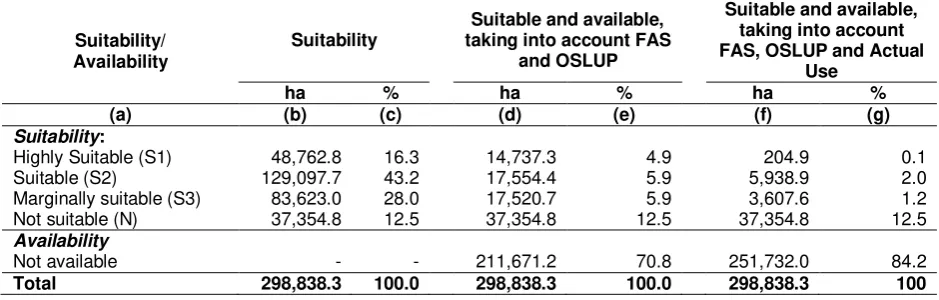
Figure 3. Map of land suitability for agriculture In terms of land availability, the forest area status map (Ministry of Forestry, 2009) and the OSLUP map (Government of Bogor Regency, 2008) are presented in Figure 4. Based on the FAS map, land can only be used for farming in the area with the status of AOU. Meanwhile, based on the OSLUP of Bogor Regency, land can only be used for agriculture in areas allocated as annual cropping, plantation, dry land and wetlands. Taking into account both maps, a map of suitable land available for agriculture according to both regulations is presented in Figure 5 (a) and Table 4 (columns d and e). This table shows that the land suitable for agriculture in Bogor Regency amounts to 49.812 ha (16.7%). This consists of various levels of land suitability; most of the land is moderately suitable (S2).
Table 4. Summary of suitable and available land for agriculture in Bogor Regency
Suitability/ Availability
Suitability
Suitable and available, taking into account FAS
and OSLUP
Suitable and available, taking into account FAS, OSLUP and Actual
Use
ha % ha % ha %
(a) (b) (c) (d) (e) (f) (g)
Suitability:
Highly Suitable (S1) 48,762.8 16.3 14,737.3 4.9 204.9 0.1 Suitable (S2) 129,097.7 43.2 17,554.4 5.9 5,938.9 2.0 Marginally suitable (S3) 83,623.0 28.0 17,520.7 5.9 3,607.6 1.2 Not suitable (N) 37,354.8 12.5 37,354.8 12.5 37,354.8 12.5
Availability
Not available - - 211,671.2 70.8 251,732.0 84.2
If then the results of this analysis are overlaid with the actual land that has been used for agriculture (for example existing paddy fields, plantations and built area), the land which still allows for the expansion of agriculture is an area of 9,751.4 ha or 3.3% of the area of Bogor Regency (Table 4, columns f and g; Figure 5b). This indi-cates that the available land for agriculture is not significant, compared with the future requirement for agricultural commodities that need to be in-creased with population growth. Subsequent analysis can still be done, for example by modelling the needs for land associated with population growth; however it is beyond the scope of this research.
This analysis shows that there is not much more suitable and available agricultural land in the hinterland of Jakarta. The solution to increase the efficiency use of existing agricultural land is to tightly comply with the official spatial land use plan.
It should be noted also the validity of this analysis, related to the use of input map. This analysis use input maps at different scales, depending on the spatial data availability. For
example, topographic maps used to derive slope, altitude, slope aspect and distance from the road is at scale of 1: 25,000. The soil class and land capability class were derived from soil map at scale of 1: 50,000. The data of forest areas sta-tuses use map at scale of 1: 250,000 because the availability of data in all Indonesian territory is only available at such scale. With advances in GIS technology, overlay maps at various scales is possible. However, globally the detail of such analysis remains at scale of 1: 250,000 which is the most un-detail map, although in the region that is not a forest, it can be said of detail analysis of 1: 50,000. Analysis using a variety of map scale was also discussed in the previous analysis using different methods of land suitability analysis (Widiatmaka et al., 2015b). Although this research used maps of various scales because of the input map availability, but basically the methodology used remain valid for application at a more detailed scale in case of the maps for such purpose were available. Certainly for this more detail planning; it would necessary additional costs for the procurement of more detailed input maps.
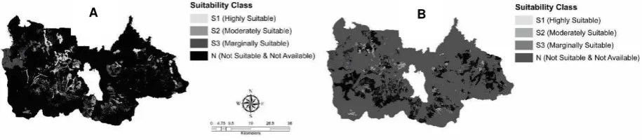
Figure 4. Map of: A. Forest area status (Ministry of Forestry, 2009); and B. allocation in official spatial land use planning (Government of Bogor Regency, 2008)
Figure 5. Map of suitable and available land for agriculture: A. taking into account FAS and OSLUP, B. taking into account FAS, OSLUP and actual land utilization
A B
Widiatmaka et al.: Spatial Multi-Criteria Decision Making for Delineating Agricultural Land in Jakarta...
CONCLUSION AND SUGGESTION
Land suitability analysis was performed in this research by using multi-criteria decision making methods that integrated many land parameters used as criteria. The parameters used include soil order, land capability class, elevation, slope and slope aspect, land use/land cover and distance to road. Results of the analysis indicate that Bogor Regency has 87.5% of suitable area for agriculture at various levels of suitability. Considering the regulation on forest area status and the official spatial land use plan, the suitable and available land for agriculture is 16.7%. Of such suitable and available land, much has already been taken for various uses. Considering this actual utilization, the area that can be used as new agricultural land is 9,751.4 ha or 3.3% of the area. The overall analysis shows that there are not many lands could be used for the expansion of agricultural land to keep pace with population growth. This result implies that in the future, land utilization should be planned more strictly, considering the strict application of existing official spatial land use plan allocation and a more efficient use of land for agriculture.
ACKNOWLEDGEMENT
The financial support for this research was given by the Center for Research, Promotion and Collaboration of the Indonesian Geospatial Infor-mation Agency. This paper was an elaboration of part of a paper presented orally at the National Congress of Indonesian Soil Science Society in Malang, October 2015.
REFERENCES
Akınci, H., A.Y. Ozalp and B. Turgut. 2013. Agricultural land use suitability analysis using GIS and AHP technique. Computers and Electronics in Agriculture 97: 71-82. doi: 10.1016/j.compag.2013.07.006 Aragonés-Beltrán, P., F. Chaparro-González, J.P.
Pastor-Ferrando and A. Pla-Rubio. 2014. An AHP (Analytic Hierarchy Process)/ ANP (Analytic Network Process)-based multi-criteria decision approach for the selection of solar-thermal power plant investment projects. Energy 66: 222-238. doi: 10.1016/j.energy.2013.12.016
Arsyad, S. 2010. Soil and water conservation (in Indonesian). Bogor: IPB Press. p. 496. Baja, S., D.M. Chapman and D. Dragovich. 2007.
Spatial based compromise programming for multiple criteria decision making in land use planning. Environmental Model-ling & Assessment 12 (3): 171-184. doi: 10.1007/s10666-006-9059-1
Bandyopadhyay, S., R.K. Jaiswal, V.S. Hegde and V. Jayaraman. 2009. Assessment of land suitability potentials for agriculture using a remote sensing and GIS based ap-proach. International Journal of Remote Sensing 30 (4): 879-895. doi: 10.1080/ 01431160802395235
Cengiz, T. and C. Akbulak. 2009. Application of analytical hierarchy process and geo-graphic information systems in land-use suitability evaluation: a case study of Dümrek village (Çanakkale, Turkey). International Journal of Sustainable Deve-lopment & World Ecology 16 (4): 286-294. doi: 10.1080/13504500903106 634 Comino, E., M. Bottero, S. Pomarico and M. Rosso.
2014. Exploring the environmental value of ecosystem services for a river basin through a spatial multicriteria analysis. Land Use Policy 36: 381-395. doi: 10. 1016/j.landusepol.2013.09.006
Effat, H.A. and M.N. Hegazy. 2012. Mapping potential landfill sites for North Sinai cities using spatial multicriteria evaluation. The Egyptian Journal of Remote Sensing and Space Science 15 (2): 125-133. doi: 10. 1016/j.ejrs.2012.09.002
Elsheikh, R., A.R.B.M. Shariff, F. Amiri, N.B. Ahmad, S.K. Balasundram and M.A.M. Soom. 2013. Agriculture Land Suitability Evaluator (ALSE): A decision and planning support tool for tropical and subtropical crops. Computers and Electronics in Agriculture 93: 98-110. doi: 10.1016/j. compag.2013.02.003
Fenton, T.E. 2006. Land capability classification. In: Encyclopedia of soil science, 2nd ed.: vol. 2. R. Lal (ed.). New York: Taylor and Francis. pp. 962-964. doi: 10. 1081/E-ESS-120001713
Mega-cities Project, Research Institute for Humanity.
Government of Bogor Regency. 2008. Decree of Bogor regency no. 19/2008 on official spatial land use plan of Bogor regency 2005-2025 (in Indonesian). Bogor. p. 116. Government of Indonesia. 2007. Law no. 26/2007 on spatial planning (in Indonesian). p. 107. Guiqin, W., Q. Li, L. Guoxue and C. Lijun. 2009. Landfill site selection using spatial infor-mation technologies and AHP: A case study in Beijing, China. Journal of Envi-ronmental Management 90 (8): 2414-2421. doi: 10.1016/j.jenvman.2008.12.008 Hidajat, J.T., S.R.P. Sitorus, E. Rustiadi and Machfud. 2013. Urban sprawl effects on settlement areas in urban fringe of Jakarta metropolitan area. Journal of Environ-ment and Earth Science 3 (12): 172-179. Kabanda, T.H. 2015. An approach to land capability evaluation for agriculture using remote sensing and GIS in Barberspan, North West Province of South Africa. African Journal of Science, Technology, Innovation and Development 7 (6): 453-461. doi: 10.1080/20421338.2015.1096671 Kusmana, C. 2011. Forest resources and forestry
in Indonesia. Forest Science and Tech-nology 7 (4): 155-160. doi: 10.1080/2158 0103.2011.625241
Malczewski, J. 2006. GIS‐based multicriteria decision analysis: A survey of the literature. International Journal of Geographical Information Science 20 (7): 703-726. doi: 10.1080/13658810600661508
Mendas, A. and A. Delali. 2012. Integration of MultiCriteria decision analysis in GIS to develop land suitability for agriculture: Application to durum wheat cultivation in the region of Mleta in Algeria. Computers and Electronics in Agriculture 83: 117-126. doi: 10.1016/j.compag.2012.02.003 Ministry of Forestry. 2009. Regulation of minister of forestry of the Republic of Indonesia no.: P.50/Menhut-II/2009 (in Indonesian). Jakarta. p. 9.
Pravitasari, A.E., I. Saizen, N. Tsutsumida, E. Rustiadi and D.O. Pribadi. 2015. Local spatially dependent driving forces of urban expansion in an emerging asian megacity: the case of greater Jakarta (Jabodetabek). Journal of Sustainable Development 8
(1): 108-119. doi: http://dx.doi.org/10.553 9/jsd.v8n1p108
Rahman, Md.R. and S.K. Saha. 2008. Remote sensing, spatial multi criteria evaluation (SMCE) and analytical hierarchy process (AHP) in optimal cropping pattern planning for a flood prone area. Journal of Spatial Science 53 (2): 161-177. doi: 10.1080/14 498596.2008.9635156
Rikalovic, A., I. Cosic and D. Lazarevic. 2014. GIS based multi-criteria analysis for industrial site selection. Procedia Engineering 69: 1054-1063. doi: 10.1016/j.proeng.2014.0 3.090
Rozman, C., M. Potocnik, K. Pazek, A. Borec, D. Majkovic and M. Bohanec. 2009. A multi-criteria assessment of tourist farm service quality. Tourism Management 30 (5): 629-637. doi: 10.1016/j.tourman.2008.11.008 Rustiadi, E., L.O.S. Iman, T. Lufitayanti and A.E.
Pravitasari. 2013. LUCC inconsistency analysis to spatial plan and land capability (case study: Jabodetabek region). In: Toward Sustainable Landuse in Asia (IV). Y. Himiyama (ed.). SLUAS Science Report 2013. pp. 1-6.
Saaty, T.L. 2008. Decision making with the analytic hierarchy process. International Journal of Services Sciences 1 (1): 83-98. Saaty, T.L. and L.G. Vargas. 2013. Decision making with the analytic network process: Economic, political, social and techno-logical applications with benefits, oppor-tunities, costs and risks. New York: Springer. p. 360. doi: 10.1007/978-1-4614-7279-7_1
Segura, M., D. Ray and C. Maroto. 2014. Decision support systems for forest management: A comparative analysis and assessment. Computers and Electronics in Agriculture 101: 55-67. doi: 10.1016/j.compag.2013. 12.005
Singer, M.J. 2006. Land capability analysis. In: Encyclopedia of soil science, 2nd edition: volume 2. R. Lal (ed.). New York: Taylor and Francis. pp. 959-961. doi: 10.1081/E-ESS-120001827
SNI. 2010. Land cover classification, SNI No. 7645: 2010 (in Indonesian). Standard National Indonesia. Indonesian National Stan-dardization Agency. p. 32.
Con-Widiatmaka et al.: Spatial Multi-Criteria Decision Making for Delineating Agricultural Land in Jakarta...
servation Service. USA: United States Department of Agriculture. p. 372. Statistics Bogor Regency. 2014. Bogor city in
figures 2014 (in Indonesian). Bogor: Statistical Agency of Bogor Regency. p.. 461.
Statistics Indonesia. 2014a. 2014. Indonesian population according to provinces 1971, 1980, 1990, 1995, 2000 and 2010 (in Indonesian). Indonesian Agency for Statistics. http://www.bps.go.id/linkTabel Statis/view/id/1267. Accessed on January 20, 2015.
Statistics Indonesia. 2014b. Area, productivity, production food crops all provinces (in Indonesian). Indonesian Agency for Statistics. http://www.bps.go.id/Subjek/ view/id/53#subjekViewTab3|accordion-daftar-subjek3. Accessed on March 15, 2015.
Statistics West Java. 2003. West Java in figures 2003 (in Indonesian). Statistical Agency of West Java Province. p. 547.
Statistics West Java. 2014. West Java in figures 2014 (in Indonesian). Statistical Agency of West Java Province. p. 558.
Ward, J., M.S. Andersen, S. Appleyard and S. Clohessy. 2010. Acidification and trace metal mobility in soil and shallow ground-water on the Gnangara Mound, Western Australia. 19th World Congress of Soil Science, Soil Solutions for a Changing World. August 1-6, 2010. Brisbane. pp. 1-4. Widiatmaka, A. Sutandi, A. Iswandi, U. Daras, M. Hikmat and A. Krisnohadi. 2014a. Estab-lishing land suitability criteria for cashew (Anacardium occidentale L.) in Indonesia. Applied and Environmental Soil Science pp. 1-14. doi: http://dx.doi.org/10.1155/ 2014/743194
Widiatmaka, K. Munibah, S.R.P. Sitorus, W. Ambarwulan and I. Firmansyah. 2015a. Multidimensional scalling appraisal of paddy field sustainability in Karawang,
West Java (in Indonesian). Jurnal Kawi-stara 5 (2): 99-220.
Widiatmaka, W. Ambarwulan, A. Sutandi, K. Murtilaksono, K. Munibah and U. Daras. 2015b. Suitable and available land for cashew (Anacardium occidentale L.) in the island of Lombok, Indonesia. Journal of Applied Horticulture 17 (2): 129-139. Widiatmaka, W. Ambarwulan, C.E. Sjamsudin
and L. Syaufina. 2015c. Geographic In-formation System and Analytical Hierarchy Process for land use planning of bee-keeping in forest margin of Bogor Regency, Indonesia. Proceeding of the The 1st International Seminar on Tropical Silvi-culture. Bogor, August 21, 2015.
Widiatmaka, W. Ambarwulan, I. Firmansyah, K. Munibah, P.B.K. Santoso and Sudarsono. 2014b. Land suitability and dynamic system modelling to define priority areas of soybean plantation in paddy fields in Karawang, West Java. Agrivita Journal of Agricultural Science 36 (3): 235-248. doi: http://dx.doi.org/10.17503/Agrivita-2014-36-3-235-248.
Widiatmaka. 2016. Integrated use of GIS, AHP and remote sensing in land use planning for tropical high altitude vegetable crops. Journal of Applied Horticulture 18 (1): xxx-xxx (article in press).
Zabihi, H., A. Ahmad, I. Vogeler, M.N. Said, M. Golmohammadi, B. Golein and M. Nilashi. 2015. Land suitability procedure for sus-tainable citrus planning using the appli-cation of the analytical network process approach and GIS. Computers and Elec-tronics in Agriculture 117: 114-126. doi: 10.1016/j.compag.2015.07.014