IJG Vol. 47, No.2, December 2015 (194 - 211) © 2015 Faculty of Geography UGM and he Indonesian Geographers Association
Land Use Planning for Brackish Water Shrimp Ponds in he North
Coast of Tuban, Indonesia
Widiatmaka, Wiwin Ambarwulan, Yudi Setiawan, Muhamad Yanuar Jarwadi Purwanto,
Taryono and Hefni Efendi
Received: 30 01 2015 / Accepted: 01 05 2015 / Published online: 15 02 2016 © 2015 Faculty of Geography UGM and he Indonesian Geographers Association
Abstract Shrimp is a commodity that is increasingly in demand. he limited land resources implies the need of efective land use planning. he objective of this study was to assess land suitability for brackish water shrimp ponds, which then will be recommended for pond development in the north coast of Tuban, Indonesia. Analytical hierarchy process (AHP) were used to obtain the weight of the diferent criteria consisted of soil characteristics, topographic, water quality, and infrastructure criteria. he suitable land for brackish water shrimp ponds was determined by weighted overlay in GIS. he results show that the study area contains highly suitable land for brackish water shrimp ponds. Land use and land cover map was interpreted from 2014 SPOT 5 imagery. he area recommended for brackish water shrimp pond was delineated by taking into account the suitability and the constraints of land use and land cover.
Abstrak Udang merupakan komoditas yang semakin diminati. Lahan yang semakin terbatas mengharuskan perencanaan
penggunaan untuk tambak udang dilakukan secara efektif. Penelitian ini bertujuan untuk mendelineasi kesesuaian lahan untuk budidaya tambak udang air payau, yang kemudian digunakan untuk menentukan lahan yang dapat direkomen-dasikan untuk pengembangan tambak di pantai utara Tuban, Jawa Timur, Indonesia. Proses hierarki analitik (AHP) di-gunakan untuk mendapatkan bobot kriteria, yang terdiri dari karakteristik lahan, topograi, kualitas air dan infrastruk-tur. Lahan yang sesuai untuk tambak udang didelineasi menggunakan overlay terbobot dalam model SIG. Hasil analisis menunjukkan bahwa pantai utara Tuban memiliki beragam tingkat kesesuaian lahan untuk tambak udang. Pada tahap berikutnya, tutupan lahan dan penggunaan lahan diinterpretasi menggunakan citra SPOT 5 tahun 2014. Wilayah yang direkomendasikan untuk tambak udang air payau kemudian didelineasi dengan mempertimbangkan kesesuaian lahan, tutupan lahan dan penggunaan lahannya.
Keywords: AHP, Coastal area, Land suitability, Land availability, Remote sensing, GIS
Kata kunci: : AHP, Wilayah pesisir, Kesesuaian lahan, Ketersediaan lahan, Penginderaan jauh, SIG
Indonesia is the largest archipelago in the world (AsianInfo.org, 2015) with as many as 13,466 islands (Indonesian Geospatial Information Agency, 2014) and a coastal length of 99,093 km (National Geographic
Widiatmaka
Dept. of Soil Science and Land Resources, Bogor Agricultural University, Indonesia Email: [email protected] Wiwin Ambarwulan
Geospatial Information Agency, Indonesia Yudi Setiawan
Center for Environmental Studies, Bogor Agricultural University Muhamad Yanuar Jarwadi Purwanto,
Dept. of Civil Engineering and Environment, Bogor Agricultural University
Taryono, Hefni Efendi
Faculty of Fisheries, Bogor Agricultural University
Indonesia, 2015), thus placing it as an archipelago country with the second longest coast in the world ater Canada (Cicin-Sain and Knecht, 1998). hese facts relect the vast coastal areas which can support many kinds of land utilization. Coastal areas are multifunctional, as they have a high biodiversity and are part of the mainland with high economic growth (Ambarwulan, 2010). his area is the most populous part of the mainland, with various life activities (Miller et al., 2005; Xu et al., 2009). Coastal areas have become associated with food, aquaculture, tourism, mining, industry, residential, ports, tourism, and other economic activities and services (Xu et al., 2009; Ambarwulan, 2010). High demand of land for such various uses in the coastal region requires optimal plans for land utilization.
Aquaculture such as in brackish water ponds is one of the potential land utilizations in coastal areas. With such a long coast, the potential of Indonesia to develop the brackish water ponds is high. he inventory of the
Ministry of Marine and Fisheries (2012) indicates that the potential for brackish water aquaculture ponds in Indonesian coastal areas comprises an area of 1.3 million ha, with developments that continue to grow. he increasing land utilization for ponds in recent years is relected by an increase of brackish water shrimp
production. he production of tiger shrimp (Penaeus
monodon), white shrimp (Penaeus indicus), Vanamei
shrimp (Litopenaeus vannamei) and others in Indonesia
in 2004 amounted to 238,567 tons; in 2013, the production had increased to 590,258 tons, an increase of 247% (Directorate General of Aquaculture, 2014). Indonesian shrimp farming experienced a very strong period of development in the 1980s (Grahadyarini, 2009; Widiatmaka et al., 2014a). Ater experiencing a dark period in the 1990s because of the disease in black tiger shrimp resulting in the destruction of ponds, the situation was recovered through wide utilization of Vanamei shrimp (Grahadyarini, 2009; Widiatmaka et al., 2014a).
Shrimp has long attracted attention due to its value as a food supply and its high economic potential (FAO, 2010). Shrimp pond in Indonesia is cultured by aquaculture isheries to meet the need for food ish. his is not only the case for Indonesia, but also globally. he world per capita supply of food ish from aquaculture has increased from 0.7 kg in 1970 (Herbeck et al., 2013) to 17.9 kg in 2008, and to 19.2 kg in 2012 (FAO, 2014). Increasing pond development has been triggered by several important factors. Globally, isheries contribute to 17% of human animal-derived protein intake and more than 50% in many countries (FAO, 2014). Food from the aquatic environment has a speciic role in providing the long-chain omega-3 fatty acids eicosapentaenoic acid (EPA) and docosahexaenoic acid (DHA), which are important for optimal brain and neural system development in children (FAO, 2014).
Aware of this potential, the Indonesian government in 2012 set the north coast of Java island as a location for shrimp pond revitalization (Indonesian Government Portal, 2015; Widiatmaka et al., 2014a) because the area is considered to have potentially favorable conditions for pond development. he coast has lat beaches, formed by the alluvial plains that facilitate aquaculture.
he north coast of Tuban in East Java Province is part of the north coast of Java potential area. his region has long been used for shrimp pond culture, and currently, brackish water shrimp ponds are growing and continue to attract many investors. According to the statistics (Indonesian Statistic, 2014), shrimp pond development on the north coast of Tuban has been fast. Production from shrimp farms in 2013 was 4,432 tons, higher than the production from inland water ish culture, at 1,953 tons. his shrimp production is still less than ish production from marine isheries, which amounted to 9,617 tons, but when looked at by economic value, the value of brackish water shrimp pond culture at 210 billion Indonesian Rupiah (1 USD
= 12,000.00 Indonesian Rupiah) was higher than that of marine ish production, which was 43 billion Indonesian Rupiah, and that of inland waters isheries at 17 billion Indonesian Rupiah. he annual increase in shrimp production is also signiicant. Shrimp production in 2013 has increased by 19.4% per year since 2008, when it only reached 2,249 tons. In the same period, sea isheries increased their production by less than 3% per year (Indonesian Statistic, 2014). his data indicates the attractiveness of increasing the shrimp pond area. However, the need for land for various sectors is constantly increasing (Sachikonye, 2005), and this fact is even more applicable in coastal areas (Xu et al., 2009; Tammi et al., 2014). herefore, in order to perform optimal land use planning, indication recommendation of the diferent levels of suitability should be provided, so that areas that can be prioritized for brackish water pond aquaculture can be deined. he planning should also consider land availability, by taking into account the existing land utilization.
as forests and mangrove forests, should be preserved, maintaining the environment to protect the coastal areas from coastal abrasion (Kusmana, 2011). he uncontrolled expansion of shrimp farming in coastal areas would cause a deterioration of the environment, because natural resources have a limited capacity to support this activity.
Remote sensing and geographic information system are among of the tools that can be used to assist site selection processes (Aronof, 1989; Ambarwulan, 2010), including selection of locations for aquaculture ponds. Various aspects of site selection can be covered by both tools which are the two important aspects in the selection of the locations for ponds. In the next part of the process, the tools can also be used for management activities i.e. site selection based on the proximity to markets, infrastructure, sources of inputs for cultivation and others (Aronof, 1989; Burrough and McDonnell, 1998; Hossain and Das, 2010; Widiatmaka et al., 2014a). Such assessments are needed, so that the application in the ield at operational level can be well planned. In the context of a comprehensive plan, geographic information systems can also be used to select areas which are still available for land uses according to the oicial rules and to the existing land utilization.
Methods for land evaluation have evolved further in recent years. In its early development, suitability determination was based only on land characteristics (FAO, 1976). Subsequently, with the help of remote sensing and geographic information systems, various other aspects including infrastructure and ease of management have been integrated through a method called multi-criteria analysis (MCA), oten also
referred to as multi-criteria evaluation (MCE) and multi-criteria decision making (MCDM) (Malczewski, 2006; Chen et al., 2010; Osly et al., 2014). Basically, this method integrates various factors that determine the land suitability for a particular use; the factors are weighted accordingly to their role in decision making (Store and Jokimaki, 2003; Mendas and Delali, 2012). his method has been widely used in other researches in making decisions and determining land suitability for agriculture (Ryan, 1998; Ceballos-Silva and Lopez-Blanco, 2003; Mendas and Delali, 2012; Akinci et al., 2013; Sarkar et al., 2014), determining the suitability of locations for landills (Bah and Tsiko, 2011; Efat and Hegazy, 2012; Gbanie et al., 2013), forestry planning (Diaz-Balteiro and Romero, 2008; Store, 2009), tourism and recreation planning (Zavadskas, 2001; Fung and Wong, 2007) and planning of appropriate locations for building (Das et al., 2010), industry (Rikalovic et al., 2014), energy (Rahman et al., 2013; Rosso et al., 2014) and airport expansion (Vreeker et al., 2002).
he objective of this study was to evaluate the land suitability of the northern coastal area of Tuban Regency, East Java Province, Indonesia for brackish water shrimp pond culture. A recommended area for brackish water shrimp pond development was then delineated by integrating the result of land suitability analysis with land cover map resulted from remote sensing analysis.
2. he Methods
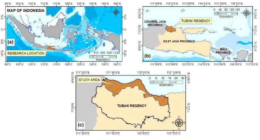
he Tuban Regency is one of the regencies of East Java Province, Indonesia. his regency has an
area of 1,839.94 km2, lies between
111°34’10.613”-Figure 1. Research area of: (a) East Java Province; (b) Tuban Regency; and (c) the north coast of Tuban
(a) (b)
112°13’22.566”E and 6°45’9.968”–7°9’56.944”S, and consists of 20 districts. he scope of this study includes the coastal districts of the regency, which are the districts along the northern coast of Java Island. he study area thus includes ive coastal district areas (Bancar, Tambakboyo, Jenu, Tuban and Palang), lying in the geographical region of 111°39’33.019”-112°12’23.677”E and 6°45’9.968”-6°59’0.117”S (Figure 1). he study area is lat, with alluvial fan, covering an area of 39,424.2 ha as the major substrate. he climate of the region is monsoonal, with an average annual rainfall of 2,132.7
mm.year-1 according to 2004-2013 data from the local
meteorological station. he rainy season is October– April.
Based on the geological map (1:100,000) of Jatirogo sheet (Situmorang et al., 1992) and Tuban sheet (Hartono and Suharsono, 1997), this region consists of several geological formations, among others the geological formations of karst rock, igneous rock and sedimentary and alluvium rock. Nonetheless, alluvium formations are the formations with the most extensive deployment, providing an early indication of suitability for aquaculture.
he data used in this research were partly obtained from ield and laboratory measurements, and were partly obtained through the calculation and processing of maps and satellite imagery. For land evaluation purposes, all of the data can be grouped into four criteria, with each criterion consisting of several sub-criteria. he soil characteristic criterion consists of three sub-criteria, which are soil pH, soil texture and soil organic carbon; the topographic criterion consists of two sub-criteria which are elevation and slope; the water quality criterion consist of four sub-criteria which are water pH, dissolved oxygen, salinity and
water temperature; the infrastructure criterion consists of two sub-criteria, which are distance to main road and distance to market. he criteria and sub-criteria used may difer with some previous studies (Hossain and Das, 2010; Widiatmaka et al., 2014a), mainly due to the diferent characteristics, and the ease of data acquisition. Soil, topography and water quality are natural resource factors that inluence the environmental quality of shrimp pond culture. Infrastructure inluences the ease of shrimp culture, in terms of marketing as well as ease of transferring the production inputs to the pond area. When used for site selection, multi-criteria evaluation may include a variety of factors, such as natural resources, infrastructure, marketing and ease of management (Hossain et al., 2007; Hossain et al., 2009; Hossain and Das, 2010; Akinci et al., 2013).
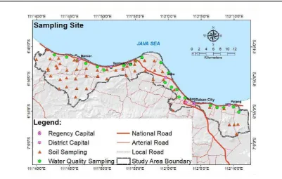
water checker. In total, 23 points were measured for water quality. Topographic maps at a scale of 1:25,000 (Indonesian Geospatial Information Agency, 2001) were used to derive the topographical data by using Arc-GIS 10.2 developed by the Environmental Systems Research Institute Inc., USA. he ease of marketing and culture input entry to the pond sites, represented by main road parameters were also obtained from the 1:25,000 scale topographic maps. In total, there are eleven sheets of 1:25,000 topographic maps which cover the study area. Market locations were obtained from ield survey.
Two major analysis steps were used in this study: biophysical brackish water shrimp pond site selection using GIS-based multi criteria analysis and identiication of land use and land cover using remote sensing. Overlay between the results of multi-criteria analysis and land use and land cover analysis was then used to delineate the recommended area for brackish water shrimp pond culture. he procedure followed is illustrated schematically in Figure 3.
In biophysical shrimp pond site selection, all data points were initially used to create map using Arc-GIS 10.1, and speciically the spatial analyst extension. Spatializing soil data was performed according to land mapping units. Spatializing water quality was done via the interpolation method, taking into account hydrogeological units in order to obtain representative water samples. Interpolation was performed using interpolation in the geostatistical module of Arc-GIS 10.2. he data was irst classiied and then weighted accordingly to its contribution to brackish water shrimp suitability, to enable the creation of a suitability map. Factor weight was classiied based on a bibliographical study and on expert judgment; suitability was classiied
into three levels: 3 (highly suitable), 2 (suitable), and 1 (not suitable) (Table 1). Five experts were consulted in order to establish this classiication.
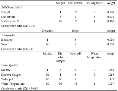
Each sub-criterion, and then criteria, was weighted in the next step. For this purpose, an analytical hierarchy process (AHP) was used. AHP was the concept introduced by Saaty (1988) for weighting many factors in decision making process. his method has been widely used because of its efective mathematical concepts (Triantaphyllou and Mann, 1995; Akinci et al., 2013). In this method, the relative criteria are compared in pairs. his procedure has been widely described and used in decision making process in land use planning (Hossain and Das, 2010; Akinci et al., 2013; Widiatmaka et al., 2014a). he ratings were derived from nine point interest scales, with values from one to one-ninth. When the line has signiicantly less importance than the column, the value of one ninth was allocated. he value of one was given when the two variables were equally important (Widiatmaka et al., 2014a). A group of experts was asked to compare the matrix in pairs for estimating such weights. he results of the pairwise comparisons conducted in this study are given in Table 2. he results indicate that the Consistency ratios (Cr) were 0.0-0.065. hese Cr were within the ratio of equal to or less than 0.10, indicated as acceptable values (Saaty, 1988).
he weights obtained from AHP were then used to determine the suitability, by multiplying the weight of the criteria with the weight of the sub-criteria and the suitability weight as predetermined in Table 1. he multiplication was performed in raster format of 25 m x 25 m on the map. he result of this multiplication was then reclassiied using equal distances as three classes Figure 3. Research methodology used for assessing recommended land suitable for brackish water shrimp ponds
on the north coast of Tuban Soil
Characteristic Infrastructure Topography Water Quality SPOT 5
Imagery (2014) Distance to Main
Road
Suitability Map Based on Sub-Criteria
Suitability Map Based on Criteria
Suitability Map for Brackish Water Shrimp Pond
Table 1. Levels of Suitability for Brackish Water Shrimp Pond In he North Coast Of Tuban According to Diferent Sub-Criteria
Sub-criteria
Suitability Range (Score)
Unit Highly Suitable
(3)
Suitable (2)
Not Suitable (1)
Soil pHa)b) - 6-8 4-6; 8-9 <4; >9
Soil textureb)c) - clay, silty clay,
clay loam
sandy clay loam, silty clay loam, silt loam
loam, sand, loamy sand,
sandy loam
Soil Organic Carbonb) % <1 1-2 >2
Elevationc)d) meter 0-10 10-30 >30
Slopec)d) % 0-2 2-3 >3
Salinityc)d) 0/00 10-20 20-35 <10; >35
Dissolve oxygene) mg/l 4-7 2.5-4 <2.5
Water pHe) - 6-8 4-6; 8-9 <4; >9
Water Temperaturea)e)f) oC 25-32 12-25 <12; >32
Distance to Marketg) km <3 3-6 >6
Distance to Main Roadh)i) km <0.5 0.5-1 >1
References: a)New (2002); b)Hossain and Das (2010); c)Widiatmaka et al. (2014a); d)Wiradisastra et al. (2004); e)Boyd
and Zimmermann (2000); f)Janssen et al. (1988); g)present study; h)Giap et al. (2005); i)Hossain et al. (2007; 2009).
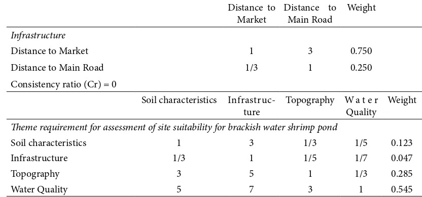
Table 2. Matrix of Pairwise Comparisons For he Assessment Of Relative Importance Of Criteria and Sub-Criteria For Brackish Water Shrimp Ponds In he North Coast Of Tuban, Indonesia
Soil pH Soil Texture Soil Organic C Weight
Soil Characteristic
Soil pH 1 1/3 3 0.260
Soil Texture 3 1 5 0.633
Soil Organic C 1/3 1/5 1 0.106
Consistency ratio (Cr) 0.047
Elevation Slope Weight
Topography
Elevation 1 3 0.750
Slope 1/3 1 0.250
Consistency ratio (Cr) = 0
Salinity
Dis-solve Oxygen
Water pH Water
Temperature
Weight
Water Quality
Salinity 1 3 5 7 0.558
Dissolve Oxygen 1/3 1 3 5 0.263
Water pH 1/5 1/3 1 3 0.122
Water Temperature 1/7 1/5 1/3 1 0.057
of suitability: highly suitable, suitable and not suitable. An analysis of SPOT 5 imagery from June 2014 (Regional Government of Tuban Regency, 2014) was conducted to obtain land use and land cover data for the study area. Image analysis of SPOT 5 was performed by a supervised classiication using image processing sotware. he standard classiication from the Ministry of Forestry (Forestry Planology Agency, 2012) was used for land use and land cover classiication. For this analysis, a series of ield checks was performed to obtain a valid imagery classiication.
3. Result and Discussion
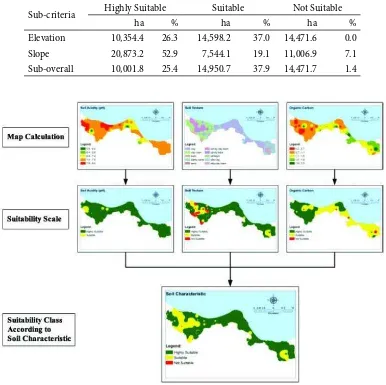
A summary of soil analysis and water quality measurement results, used as soil and water characteristics, is presented in Table 3. In Table 4 and Figure 4, the results of suitability analysis based only on the soil characteristics criteria are presented. Each step of soil characteristic criteria classiication, according to each sub-criterion, is shown in each igure, showing the results of the map calculation as well as the classiication according to the suitability scale and the resulting suitability class.
In the context of pond development, the soil is a natural body where pond is constructed and thus, diverse soil characteristics determine the success of the pond construction. Soil properties will also determine the initial cost of construction. he soils at the pond bottom and the accumulated sediments are integral parts of the pond. Concentrations of nutrients, organic matter and microorganism density at the bottom of the ponds are several orders of magnitude
greater than those in the water (Avnimelech and Ritvo, 2003; Nimrat et al., 2008) and thus should be taken into consideration. In this research, three major soil characteristics, considered to have a strong relationship to brackish water shrimp pond culture were chosen: soil pH, soil texture and soil organic carbon.
When considering only the soil pH, the majority of the area (95.3%) in the north coast of Tuban is classiied as highly suitable, and 4.7% of the area is classiied as suitable. According to soil pH, none of the area is unsuitable for brackish water shrimp pond culture. his is due to the vast inluence of sea water on the soil in this coastal area, partly because of the lat slope which allows sea water to reach and extensively inluence the soil of the coastal area. Near neutral soil pH has a positive inluence on brackish water shrimp. For this reason, the criteria used in this study apply near neutral soil pH as being more suitable (New, 2002; Hossain and Das, 2010). he relatively high soil pH of the north coast of Tuban indicates relatively high suitability for brackish water shrimp ponds. However, it should be noted that within the suitable range of soil pH, the suitability will still vary. he research of Lemonnier et al. (2004) indicates a signiicant positive correlation between the pH of the sediment surface and the osmotic pressure afecting shrimp; osmotic pressure decreased signiicantly as pH decreased from 7.0 to 6.5. Such changes in osmotic pressure inluence the physiological condition of shrimp.
he largest part of the area (76.2% of the area) is also classiied as highly suitable for brackish water shrimp pond according to soil texture, and only small part of Table 2 continued...
Distance to Market 1 3 0.750
Distance to Main Road 1/3 1 0.250
Consistency ratio (Cr) = 0
Soil characteristics
Infrastruc-ture
Topography W a t e r
Quality
Weight
heme requirement for assessment of site suitability for brackish water shrimp pond
Soil characteristics 1 3 1/3 1/5 0.123
Infrastructure 1/3 1 1/5 1/7 0.047
Topography 3 5 1 1/3 0.285
Water Quality 5 7 3 1 0.545
Max eigenvalue (γmax) = 4.109310391 n = 4
Consistency index (Ci) = (γmax - n)/(n - 1) = 0.036 Random index (Ri) = 0.9
the area (16.7% of the area) is classiied as suitable. Soil with ine soil texture is the most suitable soil for pond construction (Hossain and Das, 2010; Widiatmaka et al., 2014a). he soil at pond sites should have enough clay content to ensure that the ponds will hold water. Good quality dikes are usually built from sandy clay or sandy loam materials which harden and are easily compacted (Kungvankij et al., 1986)
According to soil organic carbon, 44.1% of the area is classiied as highly suitable, 54.5% is classiied as suitable; only 1.4% of the area is not suitable for brackish water shrimp pond culture. Only a little literature exists on the relationship between soil organic carbon and shrimp pond culture. Banerjea (1967) and Ritvo et al. (1998a) suggested that for several species, the optimum soil for shrimp pond culture contains 1.5-2.5% of soil organic carbon.
When the weights of the sub-criteria according to the AHP results are applied, 76.2% of the area is classiied as highly suitable in terms of soil characteristic criteria, 23.8% of the area is classiied as suitable for brackish water shrimp ponds (Table 4). It can thus be stated that according to the soil characteristics criteria, the north coast of Tuban has a good basic potential because most of the area is suitable for brackish water pond culture. he research of Ritvo et al. (1998b) indicated that the inluence of the substrate can be independent of the efect of water in obtaining high shrimp production, and so it is necessary to have good soil as an initial
condition for shrimp pond culture.
he results of the analysis according to topographical criteria, based on the sub-criteria of elevation and slope, are presented in Table 5 and Figure 5. Elevation and slope are important factors in determining suitability for brackish water shrimp ponds; they determine the potential of sea water with suicient salinity to enter the ponds. In the next planning, it is essential to have the detailed topography of a selected site, in order to determine pond design and farm layout. Coastal sites where the slopes run gently towards the sea make pond development easier, requiring less inancial input since excavation is minimal (Kungvankij et al., 1986; Ritvo et al., 1998a; Joyni et al., 2011). According to the elevation criterion, 37% of the area is not suitable for brackish water shrimp pond culture, and based on the slope, 28% of the area is not suitable. An analysis using the combination of both criteria resulted in 25% of the area being classiied as highly suitable and 38% as suitable for brackish water shrimp pond culture. hus, based on all topographical criteria, more than 62% of the area is classiied as either highly suitable or suitable for brackish water shrimp ponds. he 37% of the area that is not suitable in terms of topographical criteria suggests that attention should be paid to topography during pond construction, especially in the detailed engineering design phase, to ensure that water with suicient salinity can enter the pond.
Water availability is highly dependent on climate,
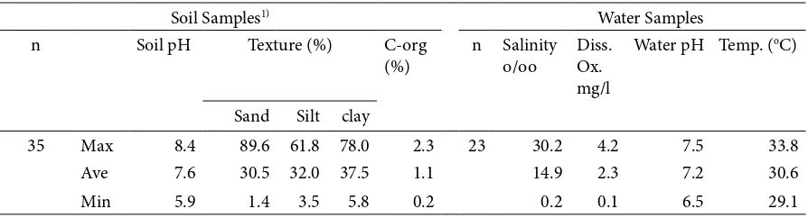
Table 3. Summary of Soil and Water Analyses Used in his Study
Soil Samples1) Water Samples
n Soil pH Texture (%) C-org
(%)
n Salinity
o/oo
Diss. Ox. mg/l
Water pH Temp. (oC)
Sand Silt clay
35 Max 8.4 89.6 61.8 78.0 2.3 23 30.2 4.2 7.5 33.8
Ave 7.6 30.5 32.0 37.5 1.1 14.9 2.3 7.2 30.6
Min 5.9 1.4 3.5 5.8 0.2 0.2 0.1 6.5 29.1
1)he soil data which consist of soil pH, soil texture and organic Carbon (C-org) of the north coast of Tuban were
extracted from the data of the soil survey of whole Tuban Regency, described in Regional Government of Tuban Regency (2014) and Widiatmaka et al. (2015), taken in the part of the north coast only for this paper.
Table 4. Land Suitability for Brackish Water Shrimp Ponds In he North Coast Of Tuban According To Soil Characteristics Criteria
Sub-criteria Highly Suitable Suitable Not Suitable
ha % ha % ha %
Soil pH 37,554.0 95.3 1,870.2 4.7 0.0 0.0
Soil texture 30,036.4 76.2 6,576.6 16.7 2,811.3 7.1
Organic C 17,362.4 44.1 21,491.1 54.5 570.7 1.4
however, the climatic data show that the study area of north coast of Tuban is suitable for shrimp pond culture in terms of rainfall. As this is a humid tropical region, the rainfall is suicient. he topographical elements that determine the ease with which saline water enters the pond are therefore more important than rainfall. his is a diferent case than that found in the Mahakam Delta (Widiatmaka et al., 2014a), where in a much wider region, the climate difered within the area analyzed.
Water quality, including all of the physico-chemical and microbiological characteristics of the water, determines the success of brackish water shrimp pond culture. here are numerous studies dealing with chemical luxes and the water quality of shrimp pond eluents (Paez-Osuna, 2001; Jackson et al., 2003; Ruiz-Fernandez and Paez-Osuna, 2004; Casillas-Hernandez et al., 2007; Dineshkumar et al., 2014). Although there are many water characteristics, only four major water characteristics, which were measurable in the ield,
were used in this research. An important element is pH, and the pH of water on or adjacent to the pond site should be within a certain range (Kungvankij et al., 1986; Ritvo et al., 2003). he normal salinity of water during high tide at diferent seasons of the year should be known in order to implement shrimp pond culture. he subsurface intrusion of salt water under the fresh-water is especially important for rivers and canals (Kungvankij et al., 1986).
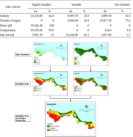
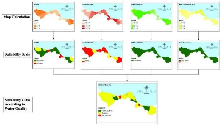
he results of analysis according to water quality measurements, in this case water pH, salinity, dissolved oxygen and water temperature, are presented in Table 6 and Figure 6.
Based on the water pH, the entire part of the study area is classiied as highly suitable. According to salinity, 10% of the area is classiied as unsuitable. Salinity is very important for shrimp ponds, although younger shrimp appear to tolerate a wider luctuation of salinity than the adults (Kungvankij et al., 1986; Casillas-Hernandez
Figure 4. he use soil characteristics criteria to assess land suitability for brackish water shrimp ponds in the north coast of Tuban
Table 5. Land Suitability For Brackish Water Shrimp Ponds in he North Coast of Tuban According To Topographical Criteria
Sub-criteria Highly Suitable Suitable Not Suitable
ha % ha % ha %
Elevation 10,354.4 26.3 14,598.2 37.0 14,471.6 0.0
Slope 20,873.2 52.9 7,544.1 19.1 11,006.9 7.1
et al., 2007). According to the dissolved oxygen, 75% of the area is unsuitable, but dissolved oxygen can be rectiied in the advanced technology used for shrimp pond culture. he maintenance of adequate levels of dissolved oxygen in pond water is very important for shrimp growth and survival. Prolonged exposure to the stress of low oxygen concentration lowers disease resistance and inhibits growth. In most cases, oxygen depletion results in the mass mortality (anoxia) of shrimp stock. his is particularly common in intensive culture operations (Kungvankij et al., 1986; Herbeck et al., 2013). According to the water temperature, 99% of the area in the north coast of Tuban is classiied as highly suitable. In tropical areas of Indonesia, water temperature is not a constraint for shrimp farming.
In the overall water quality criteria, the analysis showed that 15% of the regions can be classiied as highly suitable for brackish water shrimp ponds, and 82% of the region can be classiied as suitable. Only 2.7% of the area is not suitable for brackish water shrimp pond. he results of the water quality analysis conirm the high suitability of the northern coastal areas of Tuban for brackish water shrimp ponds.
Land suitability for brackish water shrimp ponds according to infrastructure criteria is presented in Table 7 and Figure 7. When considering infrastructure criteria including proximity to roads and markets, 21% of the land was classiied as highly suitable, and 38% was classiied as suitable. Areas comprising 42% of the north coast of Tuban are unsuitable for brackish water
Table 6. Land Suitability For Brackish Water Shrimp Ponds In he North Coast Of Tuban According To Water Quality Criteria
Sub-criteria Highly Suitable Suitable Not Suitable
ha % ha % ha %
Salinity 26,336.00 66.8 8,989.70 22.8 4,098.50 10.4
Dissolve Oxygen 0 0 9,606.90 24.4 29,817.30 75.6
Water pH 39,424.20 100 0 0 0 0
Temperature 39,259.60 99.6 0 0 164.6 0.4
Sub-overall 5,901.50 15 32,444.90 82.3 1,077.80 2.7
Figure 7. he use of infrastructure criteria to assess land suitability for brackish water shrimp ponds in the north coast of Tuban
Figure 6. he use of water quality criteria to assess land suitability for brackish water shrimp ponds in the north coast of Tuban
Table 7. Land Suitability For Brackish Water Shrimp Ponds In he North Coast Of Tuban According To Infrastructure Criteria
Sub-criteria Highly Suitable Suitable Not Suitable
ha % ha % ha %
Market 8,912.8 22.6 14,015.3 35.6 16,496.1 41.8
Main Road 17,041.5 43.2 9,429.7 23.9 12,953.0 32.9
shrimp ponds. he results of the ield survey suggest that the market is relatively small, and roads are limited to a single main paved road. he future development of shrimp farming in this region needs to be supported by improved infrastructure. his is not only true for brackish water shrimp ponds in north coast of Tuban, but also for agricultural development in Indonesia in general.
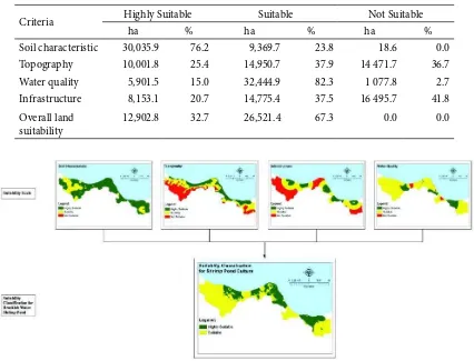
he inal suitability map for brackish water shrimp ponds is given in Figure 8, while the area of this inal suitability map is presented in Table 8.
he results show that 33% of the north coast of Tuban is highly suitable for brackish water shrimp ponds, and 67% of the area is suitable. he entire area is deemed suitable for brackish water shrimp ponds. his explains the high demand of land for the construction of brackish water shrimp pond culture in this region.
It should be noted however, that suitability alone is not suicient for the implementation of shrimp pond culture. It is necessary to know whether actual land use and land cover allows for the development of shrimp ponds. Determining current land use and land cover can provide information about the suitability and availability of the locations recommended for the development of brackish water shrimp ponds.
Land use and land cover analysis using SPOT 5 imagery on the north coast of Tuban resulted in ten
classes of land use and land cover in the north coast of Tuban (Figure 9). he existing land use and land cover classes include: forest, dry land, agricultural land, settlements, paddy ields, shrubs, existing ponds, bare land, and bodies of water. here were some areas that could not be interpreted due to cloud cover.
According to this variety of land use and land cover, some land can be deined as available for the development of brackish water shrimp pond culture, while some other land can be deined as not available for the development of brackish water shrimp ponds. Accordingly, land that can be recommended for use for brackish water shrimp was identiied based on the results of land use and land cover analysis and the results of the land suitability analysis. Technically, this is done by overlaying the maps of land use and land cover with the land suitability maps. he result is a recommendation map for brackish water shrimp pond area development (Figure 10 and Table 9).
In this recommendation map, several parts of the area can be delineated. he irst part is the area which is not recommended for brackish water shrimp ponds. Included in this not recommended area is the area where land use and land cover does not allow the development of shrimp ponds, for example existing settlements and industry. Also included in this not-recommended area are areas for the purpose
Figure 8. he inal suitability map for brackish water shrimp ponds on the north coast of Tuban Table 8. Land Suitability for Brackish Water Shrimp Ponds in he North Coast of Tuban
Criteria Highly Suitable Suitable Not Suitable
ha % ha % ha %
Soil characteristic 30,035.9 76.2 9,369.7 23.8 18.6 0.0
Topography 10,001.8 25.4 14,950.7 37.9 14 471.7 36.7
Water quality 5,901.5 15.0 32,444.9 82.3 1 077.8 2.7
Infrastructure 8,153.1 20.7 14,775.4 37.5 16 495.7 41.8
Overall land suitability
Figure 10. Recommended area for brackish water shrimp pond land use planning in the north coast of Tuban
of environmental conservation. hese include forest areas, including dry land forest and mangrove forest, of which there is very little let in Tuban. he research of Teneorio et al. (2015) shows that the considerable value of the ecosystem services provided by the mangroves especially and forest generally is greater than that of the production of shrimp in ecological and economic terms.
he second delineated part is the most recommended area. his is the area which according to the analysis is highly suitable for brackish water shrimp ponds, while according to its land use and land cover analysis, brackish water shrimp pond culture development is allowable. he third part is the recommended area. his is the area where the land use and land cover allows the development of ponds and the land suitability is assessed as suitable.
necessary. In the context of sustainable development, we must consider not only the economic standpoint, but also the physical carrying capacity of the environment, and social issues also need to be considered in a balanced manner (WCED, 1987). Analysis based on the requirements of other sectors for land utilizations is also necessary.
4. Conclusion
he study area was the north coast of Tuban, in East Java Province, where brackish water shrimp ponds have been developing signiicantly in recent years. An analysis using GIS-based multi-criteria evaluation indicates areas of diferent levels of suitability for brackish water shrimp ponds. he results of this analysis indicated that
33% of the north coast of Tuban is highly suitable for brackish water shrimp ponds, and 67% of the area is suitable. A further step of analysis taking into account the existing land use and land cover data mapped from SPOT 5 imagery showed that of the total 39,424 ha on the north coast of Tuban, 4,212.2 ha (10.7%) are highly recommended for brackish water shrimp ponds development, 11,397.5 ha (28.9%) are recommended, and 23,814.5 ha (60.4%) is not recommended for brackish water shrimp ponds. he potential area available for the development of brackish water shrimp farming on the north coast of Tuban is thus quite large, but further analysis of the land carrying capacity and the land requirements of other sectors are necessary before the expansion of ponds.
Table 9. Results of Overlaying Land Use/Land Cover Data Against Land Suitability Obtained From he Analysis and Its Recommended Use
Land use Suitability ha % Recommendation
Cloud Highly Suitable 574.8 1.5 Not Recommended
Cloud Suitable 764.7 1.9 Not Recommended
water Body Highly Suitable 96.2 0.2 Most Recommended
water Body Suitable 60.3 0.2 Recommended
Forest Highly Suitable 1,798.2 4.6 Not Recommended
Forest Suitable 4,031.9 10.2 Not Recommended
Dry Land Highly Suitable 1,834.0 4.7 Not Recommended
Dry Land Suitable 2,562.4 6.5 Not Recommended
Agriculture Land Highly Suitable 1,244.7 3.2 Not Recommended
Agriculture Land Suitable 5,277.9 13.4 Not Recommended
Settlement Highly Suitable 1,748.1 4.4 Not Recommended
Settlement Suitable 1,900.4 4.8 Not Recommended
Paddy Field Highly Suitable 1,398.9 3.5 Not Recommended
Paddy Field Suitable 678.5 1.7 Not Recommended
Shrub Highly Suitable 1,792.9 4.5 Most Recommended
Shrub Suitable 4,162.6 10.6 Recommended
Pond Highly Suitable 660.4 1.7 Most Recommended
Pond Suitable 355.3 0.9 Recommended
Bare Land Highly Suitable 1,662.7 4.2 Most Recommended
Bare Land Suitable 6,819.3 17.3 Recommended
Table 10. Recommendation Summary of Brackish Water Shrimp Pond Land Use Planning for he North Coast of Tuban
Recommendation of land use planning for brackish water shrimp pond ha %
Most Recommended 4,212.2 10.7
Recommended 11,397.5 28.9
Not Recommended 23,814.5 60.4
Acknowledgement
he authors acknowledge the Regional Government of Tuban Regency for funding the research. his paper was presented at the National Seminar of Environmental Mainstreaming in Indonesian Development in Bogor, Indonesia, 6 November 2014, and there were many improving suggestions, which have been adopted in this inal manuscript. he paper was not included in the seminar proceedings, so as to be published in this journal.
References
Akıncı, H., A.Y. Ozalp and B. Turgut (2013), Agricultural land use suitability analysis using GIS
and AHP technique, Computers and Electronics in
Agriculture, 97, 71 - 82, http://dx.doi.org/10.1016/j. compag.2013.07.006.
Ambarwulan, W. (2010), Remote sensing of tropical coastal waters: study of the Berau Estuary, East
Kalimantan, Indonesia (Unpublished doctoral
dissertation), University of Twente, Netherlands.
Aronof, S. (1989), GIS a Management Perspective.
Ottawa, Canada: WDL Publications.
AsianInfo.org (2015), Indonesia’s Geography, http:// www.asianinfo.org/asianinfo/indonesia/pro-geography.htm.
Avnimelech, Y. and G. Ritvo (2003), Shrimp and ish pond soils: processes and management,
Aquaculture, 220, 549-567, http://dx.doi. org/10.1016/S0044-8486(02)00641-5.
Bah, Y. and R.G. Tsiko (2011), Landill site selection by integrating geographical information systems and multi-criteria decision analysis: a
Case study of freetown, Sierra Leone, African
Geographical Review, 30(1), 67-99, DOI: 10.1080/19376812.2011.10539136.
Banerjea, S.M. (1967), Water quality and soil condition of ish ponds in some states of India in relation to
ish production, Indian Journal of Fisheries, 14, 113
- 144.
Boyd, C. and S. Zimmermann (2000), Grow-out systems water quality and soil management, in: M. B. New
and W. C. Valenti (eds.), Freshwater Prawn Culture:
the Farming of Macrobrachium rosenbergii, 221-238, Blackwell Science, Oxford, England. http:// dx.doi.org/10.1002/9780470999554.ch14
Burrough, P.A. and R.A. McDonnell (1998), Principles
of Geographical Information Systems, New York: Oxford University Press.
Casillas-Hernandez, R., H. Nolasco-Soria, T. Garcı´a-Galano, O. Carrillo-Farnes and F. Paez-Osuna (2007), Water quality, chemical luxes and production in semi-intensive Paciic white shrimp
(Litopenaeus vannamei) culture ponds utilizing
two diferent feeding strategies, Aquacultural
Engineering, 36, 105-114, http://dx.doi. org/10.1016/j.aquaeng.2006.09.001
Ceballos-Silva, A. and J. Lopez-Blanco (2003), Delineation of suitable areas for crops using a multi criteria evaluation approach and land use/ cover mapping: a case study in Central Mexico,
Agricultural Systems, 77, 117-136, http://dx.doi. org/10.1016/S0308-521X(02)00103-8
Chen, Y., Yu J. and S. Khan (2010), Spatial sensitivity analysis of multi-criteria weights in GIS-based land
suitability evaluation. Environmental Modelling
and Sotware, 25, 1582-1591, http://dx.doi. org/10.1016/j.envsot.2010.06.001
Cicin-Sain, B. and R. Knecht (1998), Integrated Coastal
and Ocean Management: Concepts and Practices, Island Press.
Das, S., M.Y.L. Chew and K.L. Poh (2010), Multi‐criteria decision analysis in building maintainability
using analytical hierarchy process, Construction
Management and Economics, 28(10), 1043-1056, http://dx.doi.org/10.1080/01446193.2010.501806. Diaz-Balteiro, L. and C. Romero (2008), Making
forestry decisions with multiple criteria: a review
and an assessment, Forest Ecology and Management,
255, 3222-3241, http://dx.doi.org/10.1016/j. foreco.2008.01.038.
Dineshkumar, N., C. Saravanakumar, M. Vasanth, M. Muralidhar and S.V. Alavandi (2014), Genetic and physiological characterization of denitrifying bacteria from brackishwater shrimp culture
ponds of India, International Biodeterioration
and Biodegradation, 92, 49-56, http://dx.doi. org/10.1016/j.ibiod.2014.04.017
Directorate General of Aquaculture (2014), Indonesian
Aquaculture Statistics. Directorate General of Aquaculture, Indonesian Ministry of Marine and Fisheries.
Efat, H.A. and M.N. Hegazy (2012), Mapping potential landill sites for North Sinai cities using spatial
multi criteria evaluation, he Egyptian Journal of
Remote Sensing and Space Sciences, 15, 125-133, http://dx.doi.org/10.1016/j.ejrs.2012.09.002.
Food and Agriculture Organization. (1976), A
framework for land evaluation, Soils Bulletin No.
32, Rome: Food and Agriculture Organization.
Food and Agriculture Organization (2010), he
State of World Fisheries and Aquaculture. Rome: Fisheries and Aquaculture Department, Food and Agricultural Organization.
Food and Agriculture Organization (2014), he State
of World Fisheries and Aquaculture: Opportunities and Challenges. Rome: Fisheries and Aquaculture Department, Food and Agricultural Organization.
Forestry Planology Agency (2012), Land Use and Land
Cover Map. Indonesian Ministry of Forestry (in Indonesian).
Fung, T. and F.K.K. Wong (2007), Ecotourism planning using multiple criteria evaluation with GIS,
Gbanie, S.P., P.B. Tengbe, J.S. Momoh, J. Medo and V.T.S. Kabba (2013), Modelling landill location using Geographic Information Systems (GIS) and Multi-Criteria Decision Analysis (MCDA):
Case study Bo, Southern Sierra Leone, Applied
Geography, 36, 3-12, http://dx.doi.org/10.1016/j. apgeog.2012.06.013.
Giap, D.H., Y. Yi and A. Yakupitiyage (2005), GIS for land evaluation for shrimp farming in Haiphong
of Vietnam, Ocean and Coastal Management,
48, 51-63, http://dx.doi.org/10.1016/j.
ocecoaman.2004.11.003.
Grahadyarini, B.M.L. (2009), Restoring the
glory of shrimp farming [Article], Retrieved from http://bisniskeuangan.kompas.com/ read/2009/02/25/08375379/Mengembalikan. Kejayaan.Budidaya.Udang. (in Indonesian)
Hartono and Suharsono (1997), Geological Map of
Tuban Sheet, Scale 1:100.000, Bandung: Geological Center for Research and Development.
Herbeck, L.S., D. Unger, Y. Wu and T.C. Jennerjahn (2013), Eluent, nutrient and organic matter export from shrimp and ish ponds causing eutrophication in coastal and back-reef waters of NE Hainan,
tropical China, Continental Shelf Research, 57,
92-104, http://dx.doi.org/10.1016/j.csr.2012.05.006. Hossain, M. S., S.R. Chowdhury, N.G. Das and M.M.
Rahaman (2007), Multi-criteria evaluation approach to GIS-based land suitability classiication for tilapia farming in Bangladesh,
Aquaculture International, 15, 425-443, http:// dx.doi.org/10.1007/s10499-007-9109-y.
Hossain, M.S., S.R. Chowdhury, N.G. Das, S.M. Sharifuzzaman and A. Sultana (2009), Integration of GIS and multicriteria decision analysis for urban aquaculture development in Bangladesh,
Landscape and Urban Planning, 90, 119-133, http:// dx.doi.org/10.1016/j.landurbplan.2008.10.020. Hossain, M. S. and N.G. Das (2010), GIS-based
multi-criteria evaluation to land suitability modelling for giant prawn (Macrobrachium rosenbergii) farming in Companigonj Upazila of Noakhali, Bangladesh,
Computers and Electronics in Agriculture, 70, 172-186, http://dx.doi:10.1016/j.compag.2009.10.003. Indonesian Geospatial Information Agency (2001),
Topographical Map of Tuban, East Java, Cibinong: Indonesian Geospatial Information Agency.
Indonesian Geospatial Information Agency (2014),
Indonesia has 13 466 islands registered and georeferenced [Article], Retrieved from http://www. bakosurtanal.go.id/berita-surta/show/indonesia- memiliki-13-466-pulau-yang-terdaftar-dan-berkoordinat (in Indonesian).
Indonesian Government Portal (2015), Revitalization
of shrimp industry [Article], Retrieved from http://indonesia.go.id/in/perikanan/11139-perlu-bangkitkan-kembali-industri-udang.pdf (in Indonesian)
Indonesian Statistic (2014), Tuban Regency in
Figures. Tuban, East Java: Indonesian Statistic (in Indonesian).
Jackson, C., N. Preston, P.J. hompson and M. Burford (2003), Nitrogen budget and eluent nitrogen components at an intensive shrimp
farm. Aquaculture, 218, 397-411, http://dx.doi.
org/10.1016/S0044-8486(03)00014-0.
Janssen, J.A.J., N. Bhasayavan and C. Pongsri (1988), Studies on the culture of the freshwater prawn
Macrobrachium rosenbergii at various stocking size and density in riceields, NACA/WP/88/75, FAO, Rome, 21 pp.
Joyni, M.J., B.M. Kurup and Y. Avnimelech (2011), Bioturbation as a possible means for increasing production and improving pond soil characteristics
in shrimp-ish brackish water ponds, Aquaculture,
318, 464-470, http://dx.doi.org/10.1016/j. aquaculture.2011.05.019.
Kungvankij, P., T.E. Chua, B.J. Pudadera Jr, G. Corre, E. Borlongan, L.B. Alava, I.O. Tiro, Jr., G. Potestas,
A. Taleon and J.N. Paw (1986), Shrimp Culture:
Pond Design, Operation and Management, NACA Training Manual Series No. 2, Rome: FAO Corporate Document Repository.
Kusmana, C. (2011), Forest resources and forestry in
Indonesia. Forest Science and Technology, 7(4),
155-160, http://dx.doi.org/10.1080/21580103.2011.625 241.
Lemonnier, H., E. Bernard, E. Boglio, C. Goarant and J-C. Cochard (2004), Inluence of sediment characteristics on shrimp physiology: pH as
principal efect, Aquaculture, 240, 297-312, http://
dx.doi.org/10.1016/j.aquaculture.2004.07.001 Malczewski J. (2006), GIS-based multicriteria decision
analysis : a survey of literature, International Journal of Geographic Informaton Science, 20(7), 703-726, http://dx.doi.org/10.1080/13658810600661508 Mendas, A. and A. Delali (2012), Integration of multi
criteria decision analysis in GIS to develop land suitability for agriculture: Application to durum wheat cultivation in the region of Mleta in
Algeria. Computers and Electronics in Agriculture,
83, 117-126, http://dx.doi.org/10.1016/j. compag.2012.02.003
Miller, R.L., C.E. Del Castillo and B.A. McKee
(2005), Remote Sensing of Coastal Aquatic
Environments. Springer, Dordrecht, http://dx.doi. org/10.1007/978-1-4020-3100-7.
Ministry of Marine and Fisheries (2012), Strategic
Planning 2010-2014, Indonesian Ministry of Marine and Fisheries. Jakarta.
National Geographic Indonesia (2015), Latest: Long
Coastline Indonesia Reaches 99 000 Kilometers, http://nationalgeographic.co.id/berita/2013/10/ terbaru-panjang-garis-pantai-indonesia-capai-99000-kilometer
for the culture of Macrobrachium rosenbergii, FAO Fisheries Technical Paper 428, Rome: Food and Agriculture Organization of the United Nations. Nimrat, S., S. Suksawat, P. Maleeweach and V.
Vuthiphandchai (2008), Efect of diferent shrimp pond bottom soil treatments on the change of physical characteristics and pathogenic bacteria in
pond bottom soil, Aquaculture, 285, 123-129, http://
dx.doi.org/10.1016/j.aquaculture.2008.08.020 Osly, P.J., Widiatmaka, B. Pramudya and K.
Gandasasmita (2014), Land use optimization for sugarcane plantations in Eastern Seram District,
Indonesia, Journal of Developments in Sustainable
Agriculture, 9, 89-96.
Paez-Osuna, F. (2001), he environmental impact of shrimp aquaculture: causes, efects and mitigating
alternatives, Environmental Management, 28,
131-140, http://dx.doi.org/10.1007/s002670010212. Rahman, M.M., J.V. Paatero and R. Lahdelma (2013),
Evaluation of choices for sustainable rural electriication in developing countries: A multi
criteria approach, Energy Policy, 59, 589-599, http://
dx.doi.org/10.1016/j.enpol.2013.04.017.
Regional Government of Tuban Regency (2014), Land
Carrying Capacity of Tuban Regency, Repport of Collaboration Study of Government of Tuban Regency with Bogor Agricultural University, Tuban: Regional Government of Tuban Regency (in Indonesian)
Rikalovic, A., J. Cosic and D. Lazarevic (2014), GIS based multi criteria analysis for industrial site selection, 24th DAAAM International Symposium on Intelligent Manufacturing and Automation,
2013, Procedia Engineering, 69, 1054-1063, http://
dx.doi.org/10.1016/j.proeng.2014.03.090
Ritvo, G., Y. Avnimelech and M. Kochba (2003), Empirical relationship between conventionally determined pH and in situ values in waterlogged
soils, Aquacultural Engineering, 27, 1-8, http://
dx.doi.org/10.1016/S0144-8609(02)00040-7. Ritvo, G., J.B. Dixon, T.M. Samocha, A.L. Lawrence and
W.H. Neill (1998a), Low-cost experimental unit and growth medium for testing soil efects on shrimp
culture, Aquacultural Engineering, 18, 245-249,
http://dx.doi.org/10.1016/S0144-8609(98)00036-3 Rossiter, D.G. (1996), A theoretical framework for
land evaluation: discussion paper, Geoderma,
72(1-2), 165-190, http://dx.doi.org/10.1016/0016-7061(96)00031-6
Rosso, M., M. Bottero, S. Pomarico, S. La Ferlita and E. Comino (2014), Integrating multi criteria evaluation and stakeholders analysis for assessing
hydropower projects, Energy Policy, 67, 870-881,
http://dx.doi.org/10.1016/j.enpol.2013.12.007. Ruiz-Fernandez, A.C. and F. Paez-Osuna (2004),
Comparative survey of the inluent and eluent water quality of shrimp ponds on Mexican farms,
Water Environment Research, 76, 5-14, http://
dx.doi.org/10.2175/106143004X141528.
Ryan, M.J. (1998), Multiple criteria and framing of
decisions, Journal of Information and Optimization
Sciences, 19(1), 25-42, http://dx.doi.org/10.1080/02 522667.1998.10699359.
Saaty, T.L. (1988), he Analytic Hierarchy Process.
Sufolk: Typesetters Ltd., Becceles, http://dx.doi. org/10.1007/978-3-642-83555-1_5.
Sachikonye, L. (2005), he land is the economy, African
Security Review, 14(3), 31-44, http://dx.doi.org/10. 1080/10246029.2005.9627368.
Sarkar, A., A. Ghosh and P. Banik (2014), Multi-criteria land evaluation for suitability analysis of wheat: a case study of a watershed in eastern plateau region,
India, Geo-spatial Information Science, 17(2),
119-128, http://dx.doi.org/10.1080/10095020.2013.774 106
Situmorang, R.L., R. Smit and E.J. van Vessem (1992),
Geological map of Jatirogo sheet, Scale 1:100.000, Bandung: Geological Center for Research and Development.
Store, R. and J. Jokimaki (2003), A GIS-based multi-scale approach to habitat suitability modeling,
Ecological Modelling. 169, 1–15, http://dx.doi. org/10.1016/S0304-3800(03)00203-5.
Store, R. (2009), Sustainable locating of diferent forest uses, Land Use Policy 26, 610–618, http://dx.doi. org/10.1016/j.landusepol.2008.08.013.
Tammi, I. and R. Kalliola (2014), Spatial MCDA in marine planning: Experiences from the Mediterranean and
Baltic Seas, Marine Policy, 48, 73–83, http://dx.doi.
org/10.1016/j.marpol.2014.03.015.
Tan, K.H. (2002), Soil Sampling, Preparation and
Analysis, New York: Marcel Dekker.
Teneorio, G.S., P.W.M. Souza-Filho, E.M.L.S. Ramos and P.J.O. Alves (2015), Mangrove shrimp farm mapping and productivity on the Brazilian Amazon coast: Environmental and economic
reasons for coastal conservation, Ocean and
Coastal Management, 104, 65-77, http://dx.doi. org/10.1016/j.ocecoaman.2014.12.006.
Triantaphyllou, E. and S.H. Mann (1995), Using the analytic hierarchy process for decision making in engineering applications: some challenges.
International Journal of Industrial Engineering: Applications and Practice, 2 (1), 35–44.
Vreeker, R., P. Nijkamp and C.T. Welle (2002), A multi criteria decision support methodology for
evaluation airport expansion plan. Transportation
Research, Part D7, 27-47, http://dx.doi.org/10.1016/ S0969-6997(01)00005-9.
Widiatmaka, W. Ambarwulan, B. Riadi, I. Nahib, S. Budhiman and A. Halim (2014a), Spatial multi criteria land evaluation and remote sensing for area delineation of shrimp pond culture revitalization in
Mahakam Delta, Indonesia, Proceeding of the 12th
(Pp. 839-847), Bali-Indonesia.
Widiatmaka, A. Sutandi, I. Anas, U. Daras, M. Hikmat and A. Krisnohadi (2014b), Establishing
land suitability criteria for cashew (Anacardium
occidentale L.) in Indonesia, Journal of Applied and Environmental Soil Science, 2014, 1-14, http:// dx.doi.org/10.1155/2014/743194
Widiatmaka, W. Ambarwulan, M.Y.J. Purwanto, Y. Setiawan and H. Efendi. (2015), Land capability based-environmental carrying capacity in Tuban,
East Java, Jurnal Manusia dan Lingkungan, 22(2),
247-259 (in Indonesian).
Wiradisastra, U.S., Widiatmaka, M. Ardiansyah and
K. Nirmala (2004), Suitability of marine culture,
Jakarta: Center for Survey of Marine Resources, Geospatial Information Agency.
World Commission on Environment and Development
(WCED) (1987), Our Common Future, New York:
Oxford University Press.
Xu, X., H. Peng, Q. Xu, H. Xiao and G. Benoit (2009), Land changes and conlicts coordination in coastal urbanization: a case study of the Shandong
Peninsula in China. Coastal Management, 37(1),
54-69, http://dx.doi.org/10.1080/08920750802612788. Zavadskas, E.K., A. Kaklauskas, S. Raslanas and V.
Malienė (2001), he application of multicriterion methods for valuation of recreation property,