DEVELOPMENT OF FLOOD EARLY WARNING SYSTEM
AT TAMAN MERDEKA, BATU BERENDAM, MELAKA
IZUWATI BT ABD RAZAK
UNIVERSITI TEKNIKAL MALAYSIA MELAKA
DEVELOPMENT OF FLOOD EARLY
WARNING SYSTEM AT TAMAN MERDEKA,
BATU BERENDAM, MELAKA
Thesis submitted in accordance with the partial requirements of the
Universiti Teknikal Malaysia Melaka for the
Bachelor of Manufacturing Engineering (Design Manufacturing)
By:
IZUWATI BT ABD RAZAK
B050510076
Faculty of Manufacturing Engineering
APPROVAL
This PSM submitted to the senate of UTeM and has been as partial fulfillment of the requirements for the degree of Bachelor of Manufacturing Engineering (Design
Manufacturing). The members of the supervisory committee are as follow:
DECLARATION
I hereby, declared this thesis entitled Development of Flood Early Warning System at Taman Merdeka Batu Berendam, Melaka is the results of my own
research
except as cited in references.
Signature : ……….
Author’s Name : IZUWATI BI NTI ABD RAZAK
DEDICATION
For my beloved mother and father and my lovely husband and
ACKNOWLEDGEMENTS
Alhamdulillah, all the praise is to God, Allah S.W.T. because of his permission, I can finish my Projek Sarjana Muda 2 (PSM 2). I got a lot of new knowledge and experience about this final project.
In this opportunity, I would like to express my highest gratitude especially to my supervisor, Encik Fairuz bin Dimin because gave me a lot of support and advice to finished my PSM 1 and 2 and also for the time as he had gave me so much information and guidance to this final project. Not to forget, I also want to say thanks to all UTeM staff and member that have worked hard in order to enable me, teach and show me about this project.
Last but not least, I would like to say thank you to UTeM because give me a change to get an experience and learn more about what I had learn to related my study in PSM 2. And to my family and all my fellow friends who have been helping me and giving tips on how I can work through this PSM 2 and for supporting me in all time through.
ABSTRACT
ABSTRAK
TABLE OF CONTENTS
1.1 BACKGROUND OF THE PROBLEM ………..1
1.1.1 Flood in Malaysia and research’s place………...1
1.2 STATEMENT OF THE PROBLEM ………..………...6
1.2.1 Flood Statistics and problems...………..6
1.2.2 Telemetric System ………...………..8
1.3 OBJECTIVES………9
1.5 IMPORTANCE OF THE PROJECT………10
1.6 ORGANIZATIONS OF THE TERMS………..11
1.6.1 Abstract ………11
1.6.2 Chapter 1 –Introduction………...11
1.6.3 Chapter 2 –Literature review………...12
1.6.4 Chapter 3 – Methodology……….12
1.6.5 Chapter 4 –Results………...13
2.1.3 Flood Forecasting and Warning System for Kelantan River……….16
2.1.4 Comprehensive Flood Loss Prevention and Management of Kelantan River Basin………17
2.2 BACKGROUND -BROAD AREA………..18
2.2.1 Major flood events and causes of flooding………18
2.2.2 Flood Control Measures………19
2.2.3 Structural Measures (Engineering Solutions)...20
2.3 BACKGROUND –FOCUS AREA………..25
2.3.1 Forecasting and Warning System………..25
2.4 BACKGROUND –RELATED TOOLS AND TECHNIQUES………….26
2.4.1 Flood early warning system operation………..27
2.5 REVIEWS ON PREVIOUS STUDIES OR CASES………..28
2.5.1 Limitations of Smsbanjir………...31
CHAPTER 3 METHODOLOGY………34
3.1 DEVELOPMENT OF FLOOD EARLY WARNING SYSTEM………..34
3.1.1 Water level sensor circuit………35
3.1.2 0.5 ~ 100 Second IC Timer circuit………..35
3.1.3 1-watt Audio IC Mono Power Amplifier circuit………...…..36
3.2 PROCESS PLANNING………..38
3.2.1 Find and choose suitable project circuit……….38
3.2.2 Manufacturing process steps………..38
3.3 HAND TOOLS AND MACHINES USED………..43
CHAPTER 4
5.3 THE FINDING AND COMPARISON WITH OTHER METHOD……58
CHAPTER 6 CONCLUSION AND RECOMMENDATIONS………...…60
6.1 FUTURE WORK………..………61
REFERENCES………..………62
LIST OF FIGURES
No. Titles Pages
1.1 The area normally affected by flood 3
1.2 Melaka River location near the Taman Merdeka 4
1.3 Location of Taman Merdeka, Batu Berendam, Melaka 5
1.4 Monsoon rain 7
1.5 Stick gauge 8
2.1 Flood early warning system operation 27
2.2 Telemetric system at TTDI area 29
3.1 Block diagram of the project 37
3.2 Flow chart of process steps 39
3.3 Soldering process 42
3.4 Product cover design 42
4.1 Communication circuit 50
4.2 Water level circuit 51
4.3 IC timer circuit 53
4.4 Power amplifier circuit 54
4.5 Block diagram of the project 55
4.6 Electronics Circuit Operation System Of The Flood Early Warning System
LIST OF TABLES
No. Titles Pages
1.1 Project total cost 11
2.1 Category of SMS Flood Warning system 30
4.1 Components testing 47
4.2 Water level sensor components 51
4.3 Timer Relay Circuit 52
4.4 Timing duration of IC Timer Circuit 52
LIST OF ABBREVIATIONS, SYMBOLS, SPECIALIZED
NOMENCLATURE
MMD - Malaysia Meteorological Department DID - Department of Irrigation and Drainage BKN - National Security Division
SMS - Short Messages System
IRBM - Integrated River Basin Management VHF - Very high frequency
Development of Flood Early Warning System at Taman Merdeka, Batu Berendam, Melaka
CHAPTER 1
INTRODUCTION
1.1 BACKGROUND OF THE PROBLEM
1.1.1 Flood in Malaysia and research’s place
Malaysia experiences a major flood event every year due to the adverse effects of two monsoon seasons a year. Floods have thus become the most significant natural disaster in the country in terms of the population affected, frequency, aerial extent, financial cost and the disruption to socio-economic activities. Many previous flood control measures have had different levels of success but have generally had little effect in reducing the problem. However, it is now understood that it is neither possible nor desirable to control floods completely.
This project discusses the framework of a proposed flood early warning system for the Durian Tunggal river basin that is cause flooding at Taman Merdeka, Batu Berendam when heavy rainfall and serious flooding example during last year in December 2006.
Development of Flood Early Warning System at Taman Merdeka, Batu Berendam, Melaka
flood event of 1925 when floods occurred along the Kinta River in Perak and Klang River in Selangor and Bernam River in Selangor/Perak boundary. It is also known that the flood warning system based on river levels of the Kelantan River at Bradley Steps, Kuala Krai has been used to warn the people of Kota Bharu downstream since early 1900’s. The police were reading and transmitting the rainfall and water level information via VHF sets to the Flood Warning and Relief Committee in Kota Bharu.
After the floods of 1971, the flood warning systems of major rivers subjected to severe flooding were reviewed. The major deficiencies identified were inadequacy of rainfall and water level station networks to provide timely and reliable real-time data. Based on this review and its recommendations, telemetric stations, both rainfall and water level, were established at strategic locations to enable the transmission of real-time data to flood operation centers. The review also highlighted the need for more accurate flood forecasting techniques to replace the empirical river stage correlation technique, and recommended the use of mathematical models, which would take into account the rainfall and catchments characteristics as well as river system configurations.
Development of Flood Early Warning System at Taman Merdeka, Batu Berendam, Melaka
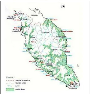
Figure 1.1: The area normally affected by flood
Development of Flood Early Warning System at Taman Merdeka, Batu Berendam, Melaka
(MMD), JPA3, DID, and National Security Division (BKN) at Prime Minister Department.
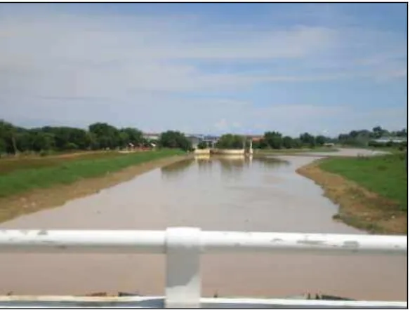
But at research’s area, Taman Merdeka Batu Berendam, it still has a seriously flooding especially flash flood example during last year in December 2006. A part people respectively cannot manage to property rescue because the water increase too fast. It is because Melaka River which situated near the Taman Merdeka had overflowed till to the residential area and drain water also had overflowed caused floods become to worse. If flash flood occurred, inhabitants could not expect water will rise up quickly. This is because water from the drain could not flow nicely into the river. These resulted flash floods deteriorate.
Figure 1.2: Melaka River location near the Taman Merdeka
Development of Flood Early Warning System at Taman Merdeka, Batu Berendam, Melaka
a few hours). Because they come with little warning, flash floods are the most dangerous to human lives.
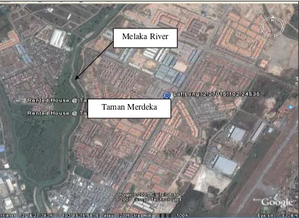
Figure 1.3: Location of Taman Merdeka, Batu Berendam, Melaka.
From the figure above, it showed that Melaka River about 1km from main road of Taman Merdeka. Melaka River is flow from the Durian Tunggal Dam and 14ft – 22ft only from the sea level. This dam is constructed to retain flood water in order to protect areas downstream of the dam. Construction of storage dam solely for flood control purposes is generally economically not viable and frequently utilised for other purposes such as water supply. In addition, dams constructed for hydro-electric purposes also have a portion of their capacity allocated for flood detention.
Melaka River
Development of Flood Early Warning System at Taman Merdeka, Batu Berendam, Melaka
Flooding along rivers is also a natural event. Some floods occur. Water fills river basins too quickly, and the river will overflow to its banks. Often the land around a river will be covered by water for miles around.
1.2 STATEMENT OF THE PROBLEM
1.2.1 Flood Statistics and problems
Since 1971, the Department of Irrigation and Drainage (DID) has been designated with the task to implement structural flood mitigation works. Flood mitigation plans have been developed for 17 major river basins and 27 towns. Based on these plans, various structural and non-structural measures have been proposed and implemented in stages. Such measures include improving river channel sections, building of flood bunds, ring bunds, by-pass flood ways, use of mining ponds for flood attenuation and construction of flood retention dams to regulate flood flows and minimize flood occurrence.
Floods cannot be totally prevented through structural measures due to technical and economic reasons. Consequently flood forecasting and warning service constitutes an effective and economical means to reduce live loss and property damage. Since 1971, DID have been designated with the task to provide flood forecasting and warning services such as:
1.2.1.1Wood marker
Development of Flood Early Warning System at Taman Merdeka, Batu Berendam, Melaka
area which always flooding and is only act as water measurement only by visual check
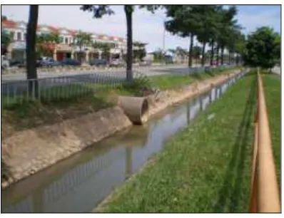
1.2.1.2Monsoon rain
Near the resident’s house Taman Merdeka, government was built up a monsoon
rain along the road in Taman Merdeka near the stream. But this method did not effect to the flooding from happen.
Figure 1.4: Monsoon rain
1.2.1.3Stick gauge