CLASSIFICATION OF MEANDERING RIVERS:
INTERPRETING THE MORPHOLOGICAL RIVER
BY USING THE PLANIMETRIC
CHARACTERISTICS
Yuri Sukamto
1, Robby Yussac Tallar
2, William Trisina
3 1Maranatha Christian University, Civil Engineering Department,
Jln.Prof. drg. Surya Sumantri No.65, Bandung 40164, Indonesia
2Maranatha Christian University, Information Technology Department
Jln. Prof. drg. Surya Sumantri No.65, Bandung 40164, Indonesia
3
National Cheng Kung University, Hydraulic and Ocean Engineering Department
University Road No. 1, Tainan 701, Taiwan
[email protected] (Robby YussacTallar)
Abstract
It must be recognized that rivers differ among themselves, and through time,one river can
vary significantly in itsdownstream direction. Most of the riversclassification was published
by US or European researchers. In fact, these classifications of the river cannot be applied
thoroughly to other regions such Asian Countries due to its differentcharacteristics and
situations. Therefore, the general purpose of thisresearch is to establish a simple and
easy-to-use practice in interpreting the morphological aspect of river by using planimetric
characteristics. We selected four major rivers to develop the conceptual model for
classification of meandering rivers in Borneo (Kalimantan) Island. Further, we divided the
meandering rivers in Borneo Island by three zones to get the informed data in detail. Based on
the results, the variability variesin all planimetric characteristics except the slope, which is
considered as conformity.
Keywords: meandering rivers; Google Earth; river's classification
Presenting Author’s biography
Yuri Sukamto
Robby YussacTallar, Ph.D.
1.
Introduction
Fluvial processes over various time periodsalter geomorphologic characteristics of natural rivers such as the longitudinal profile and the channel of cross-sectional geometries [1]. It must be recognized that rivers differ among themselves, and through time, one river can vary significantly in itsdownstream direction. The variability of large alluvial rivers is an indication that some variables controlled the type of river or river pattern [2]. These variables are used by many researchers for defining the riversclassification. Most of riversclassification was published by US or European researchers. In fact, these classifications of the river cannot be applied thoroughly to other regions such Asian countries due to its different characteristics and situations. Meanwhile, there are only very few researchers from Asian Countries who provided their own riversclassification. Therefore, the general purpose of thisresearch is to establish a simple and easy-to-use practice in interpreting the morphological aspect of river. The specific purpose is to develop conceptual model for classification of meandering rivers in Borneo (Kalimantan Island), Indonesia. Therefore, it is expected that the result will be considered as appropriate classification of meandering rivers in Borneo Island.
2.
Method
Study Area
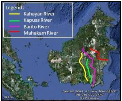
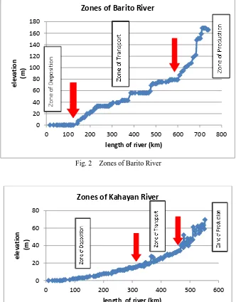
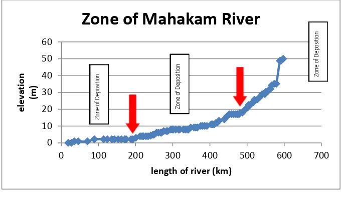
Our research is focused on the meandering rivers due to its commonality in Borneo Islands. We selected four major rivers in Borneo Island: Kahayan River, Kapuas River, Barito River, and Mahakam River. By using Google earth, we investigated the planimetric characteristics (river width, river sinuosity, amplitude, meander belt, wavelength, bend sharpness, meander pattern, and width-to-depth ratio) in the fourmajor rivers. First of all, we divided the rivers by three zones: zone of deposition, zone of transport, and zone of production. Then, we identified and defined these zones by regarding their elevation, slope and the length.
Fig. 1 Four Major Rivers in Borneo Island
[image:2.595.207.406.449.614.2]Fig. 2 Zones of Barito River
Fig. 3 Zones of Kahayan River 0
20 40 60 80 100 120 140 160 180
0 100 200 300 400 500 600 700 800
e
le
v
a
ti
o
n
(m
)
length of river (km)
Zones of Barito River
0 20 40 60 80
0 100 200 300 400 500 600
e
le
v
a
ti
o
n
(m
)
length of river (km)
Zones of Kahayan River
10 20 30 40 50
e
le
v
a
ti
o
n
(m
)
[image:3.595.140.472.75.500.2] [image:3.595.146.470.422.716.2]Fig.5 Zones of Mahakam River
The range of these zones can be seen in the Tab. 1.
Tab. 1 Description of study area
Zone of Sediment
Barito
River
Kahayan
River
Kapuas
River
Mahakam
River
Zone of deposition
141330 m
335146 m
173156 m
200482 m
Zone of transport
453868 m
127429 m
247660 m
295677 m
Zone of production
144255 m
89978 m
51835 m
100874 m
Borneo Classification
The analysis based on the planimetric characteristics of meandering rivers by using Google earth software [3]. The data are justified to formulate the range for every characteristic [4-7].
River Width (w)
Based on Kern et al. (1994), the type of river can be classified by its width. For large river, the width should be more than 220 m. However, Heirich et al. (1999) classified rivers with width wider than 10 m as a large river. For our case, the classification is shown in Tab. 2.
Tab. 2 The offered classification based on its width
Types of River
Range of Width (m)
Very Large River
>300
Large River
100 – 300
Middle River
50 – 100
Small River
<50
River Sinuosity (P)
Sinuosity is the result of the process when the stream naturally dissipatesits flow forces. Sinuosity should be visually estimated or measured in the field because sometimes, the sinuosity of small headwater streams approximated from maps or aerial photos are not always accurate. According to Brice (1984), meandering rivers have sinuosity larger than 1.25; according to Leopold et al. (1964) and Rosgen (1994) the lower limit is 1.5 [5]. The offered classification based on its sinuosity can be seen in Tab. 3.
0 10 20 30 40 50 60
0 100 200 300 400 500 600 700
e
le
v
a
ti
o
n
(m
)
[image:4.595.136.479.71.268.2]Tab. 3 The offered classification based on its sinuosity
Types of River
Range of Sinuosity
Very highly meandering
>2
Highly meandering
1.5 – 2
Moderate meandering
1.25 – 1.5
Low meandering
<1.25
Amplitude (A)
The maximum distance from the down-valley axis to the sinuous axis of a loop is the meander width or amplitude. Large-amplitude of meandering rivers develops multiple scour holes within a single bend that are observed to be part of overlapping shingle bars (Whiting and Dietrich, 1993). Tab. 4 presents the offered classification based on its amplitude.
Tab. 4 The offered classification based on its amplitude
Types of River
Range of Amplitude
Very highly amplitude
>2000
Highly amplitude
1500-2000
Moderate amplitude
1000-1500
Low amplitude
<1000
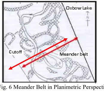
Meander Belt (MB)
[image:5.595.216.390.414.566.2]Camporeale et al. (2005) define the meander belt as the proportion of floodplain having 90% probability of containing the river channel during its long-term evolution. We analyzed the meander belt of fourmajor rivers in Borneo Island based on the planimetric perspective (Fig. 6). We found that the average width of the meander belt was:
Fig. 6 Meander Belt in Planimetric Perspective
(Source: Schumm, 2005, River Variability and Complexity, Cambridge Univ.Press)
Wavelength (WL)
Bend Sharpness (γ)
The bend sharpness (γ) is represented by the ratio of river width to radius of curvature of the river
centerline. The offered classification based on its bend sharpness can be seen in Tab. 6.
Tab.6 The offered classification based on its bend sharpness
Types of River
Range of Bend Sharpness
Sharp meandering
>0.5
Moderate meandering
0.1 – 0.5
Mild meandering
<0.1
Meander Pattern (MP)
A variety of river changes are listed under a patterned change (Fig. 7). In meander changes, meander enlarges if its amplitude and width increase. Meander shift involves the displacement of the meander in itsdownstream direction. Commonly,the meander both grows and shifts downstream, even though some parts of the bend can actually shift upstream. In Borneo Islands, the pattern changes occurred due to human activities such as agricultural practices.
Fig. 7The Meander Pattern
(Source: Southerland,2004, www.geomorph_terms.pdf)
Width to depth ratio (w/d ratio)
Width to depth ratio is the ratio of the top width of the channel at bankfull stage to the depth at bankfull. The depth is found by observingthe cross sectional area of the channel by the width. The following table shows the offered classification based on its width to depth ratio.
Tab. 7 The offered classification based on its width to depth ratio
Types of River
Range of width to depth ratio
Large meandering
<25
Moderate meandering
25 – 40
Low meandering
>40
Slope (s)
Slope can be calculated from the elevation and the length of each reach of river.Tab. 8 presents the offered classification based on its slope.
Tab. 8 The offered classification based on its slope
Types of River
Range of slope
Steep
> 0.05
Moderate
0.01 – 0.05
3.
Results
Comparison with Rosgen Classification
After developingourown classification for Borneo Island (Tab. 9), we compared the results with Rosgen Classification [5] as one of famous riversclassification in the world (Tab. 10).
Tab. 9 The offered classification of meandering rivers in Borneo Island
River Type
Description
A
P >2; A>1500m; WL >2000m; γ>0.1 ;w/d ratio <25 ; s <0.1%
B
P 1.5-
2; A>1000m; WL >2000m; γ>0.1 ;w/d ratio >25 ; s <0.1%
C
P 1.25-
1.5; A>1500m; WL >5000m; γ>
0.1 ;w/d ratio >25; s <0.1%
D
P 1.0-
1.25; A>1000m; WL >2000m; γ>0.1 ;w/d ratio <25; s <0.1%
Tab. 10 Comparison with Rosgen Classification
River
Borneo Classification
Rosgen Classification
Barito River
River Type C
River Type C or F
Kahayan River
River Type B
River Type C or F
Kapuas River
River Type A
River Type C or F
Mahakam River
River Type B
River Type C or F
The comparison between Borneo Classification and Rosgen Classification is only based on the width to depth ratio, sinuosity, and slope. All river types have theirown range of variables to determine the river types.
4.
Conclusion
Natural rivers exhibit dynamic variability in their flow characteristics. In case of meandering rivers in Borneo Island, we divided the river by three zones to get the informed data in detail. Based on the results, the variability variesin all planimetric characteristics except the slope, which is considered as conformity.. It is a simple method and easy-to-use practice by using GoogleEarth to measure planimetric characteristics in classifying the rivers if there is no data or lack of supporting data.
References
[1] K. Paik, D. Jung and J. H. Kim, Flow Variability and Channel Geometry of The Seomjin River, in Kusuda T. (Eds) Preprints of The Fifth APHW Conference“Hydrological Regime and Water Resources in the Context of Climate Change”, Vietnam,November 8 – November 10, pp. 79-95. 2010.
[2] J. D. Allan, Stream Ecology: Structure and function of running waters. Chapman & Hall, New York, USA. 1995.
[3] Google Earth software, 2010.
[4] A. Crosato. Analysis and modelling of river meandering. IOS Press, Netherland, 2008.
[5] Rosgen Stream Classification (2004), www.RosgenStreamClassification.pdf