Integrated Watershed Management to Prevent Floods and Sustain
Water Resources In Jakarta, Indonesia
Naik, Sinukaban, Trihono Kadri
Bogor Agricultural University, Watershed Management Bogor, Indonesia
Abstract
There are nine major rivers flowing through Jakarta, the capital city of Indonesia. Total extent of the nine watersheds in Jakarta and its vicinity is about 106 000 ha . Average annual rainfall of 17 stations (1972-1999) throughout the watersheds is 2 973 mm. These make the total water resources throughout Jakarta is about 3.151 billion cubic meters per year (cmy).
Average water demand for agricultural uses is about 4.0 mm perday or 1 460 mm per year or 1.548 billion cmy throughout the watersheds. Therefore, the total annual retained water as storage in the soils, ponds, lakes, reservoirs, ground water,vegetations, rivers, and for municipal use will be only 1 513 mm or 1.296 billion cmy.
Water demand (municipal use) for 11 million people in the nine watersheds is about 1.288 billion cmy or 360 liter per capita per day in urban area and 180 liter in rural area. Water demand for industries uses is about 16 million cmy.
Water loss through floods during rainy seasons is about 1.020 billion cmy due to the increasing runoff coefficient of the watersheds Changing land use and improper agricultural management are likely the main cause of the increasing runoff coefficient.
The losses of water have caused inevitable lacking of water for municipal uses during dry seasons. It is clear from this analysis that the water problems in Jakarta is not only frequent and high floods in rainy seasons but also lacking of water for municipal use in dry seasons. These situations seem to be worse in the future. Therefore, the water problems in Jakarta need an extremely great attention. The key to undertake these problems is a set of activities in an integrated and holistic watershed management programs which may called Jakarta Megapolitan Water Management System.
Key Words : Water resources,Floods, Watershed, Rainfall.
Introduction
Jakarta as capital city of Indonesia has become a metropolitan city like any other capital city in the world. Total population of Jakarta has reached 8.6 million in 2003 with population density about 12 960 people per square kilometer (BPS,2003).
This city has also become the center of business activity; it contributes about 34 % of the total economic activities of Indonesia.
The growing population and business activities have caused a tremendous conversion of agricultural land for houses, shopping centers, schools, offices industrial parks, parking area, highways, and airports. These changing land use is likely become the source of much erosion/sediment, runoff and garbage that fill and pollutes rivers, drainage channels and reservoirs (ponds, lakes) which in turn causing floods in rainy seasons. On the other side, the changing land use is the main cause of decreasing infiltration and ground water table and in turn causing drought in dry seasons.
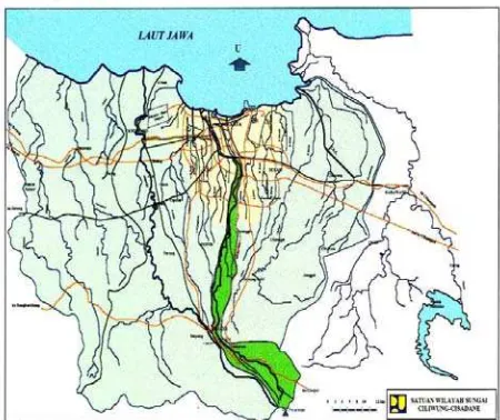
Ciliwung watershed. Therefore, the total water resources and demands of Jakarta will be calculated based on recorded data in Ciliwung watershed.
Figure 1. Jakarta and the nine major watersheds.
Table 1. Major Rivers (Watersheds) in Jakarta (NEDECO, 1973)
Rivers/waters hed
Area (Sq km)
Length (km)
Lowest elevation (m)
Highest elevation (m)
Cakung 55 33 6 90
Buaran 30 23 9 45
Sunter 73 40 12 122
Cipinang 48 36 12 107
Ciliwung 347 117 8 2908
Krukut 98 37 7 117
Grogol 33 27 29 100
Pesanggrahan 110 83 3 205
Angke 263 100 3 220
Total 105.7
Water Resources
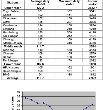
Table 2. Daily and annual rainfall (mm) of Ciliwung Watershed (Fakhrudin, 2003)
Stations Average daily rainfall
Maximum daily rainfall
Annual rainfall
Upper reach 122.2 3832 7
Tugu Selatan 101 162 3541
Citeko 102 151 3303
Cibeureum 102 150 3480
Ciawi 135 227 3925
Katulampa 114 150 3834
Empang 128 210 4210
Hambalang 136 200 4116
KBR-Bogor 138 262 4124
Cimanggu 132 160 4130
Atang Sanjaya 134 316 3736
Middle reach 111.7 2594
Cibinong 110 180 3153
Citayam 109 155 2579
Depok 95 126 2562
Psr Minggu 133 170 2082
Lower reach 102.6 1828
HP. Kusuma 105 162 1901
Rawamangun 108 181 1771
BMG 94 148 1812
Average 110.7 2 973
Figure 2. Monthly stream discharge of Ciliwung 0
5 10 15 20 25 30 35 40
J F M A M J J A S O N D
Dischar
g
Not for cited without written permission
Water Demands
Water demands for societal uses is divided into three major uses: municipal uses, industrial uses, and agricultural uses.
Municipal demand included water for domestic purposes, commercial use, fire protection, street washing, and lawn and garden irrigation. In Jakarta, the municipal uses is provided through municipal water system with the rate of 360 ℓ/capita/day in urban area and 180 ℓ/capita/day in rural area. The capacity of the municipal water system is only 13.93 cms or 439.296 million cmy make the system can serve only 3.343 million people or 38.8% of the population.
Since the total population of Jakarta and its vicinity in the watershed is about 11 million, which consists of 8.6 million in urban area and 2.4 million in rural area the total demand for municipal uses is about 1.305 billion cmy. Water demand for industrial uses is ranged from 125-1000 cubic meter per day (cmd) for about 88 industries in Jakarta; this make the total water demand for industries uses is about 16 million cmy.
Water demand for agricultural (forest, upland agriculture, paddy rice, garden, etc) is calculated with the assumption of evapotranspiration about 4.0 mm per day; this make the total water demand for agricultural is 1460 mm per year or 1.548 billion cmy. Societal demand for water in Jakarta and its vicinity, therefore, is about 2.852 billion cmy (Table 3).
Table 3. Water Balance in Jakarta and its vicinity
Water Resources (billion cmy) Water demands (billion cmy)
Stream discharges
Available water 1.824 Total demands 2.852
Defisit 1.028
Watershed Problems
Floods and water losses
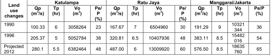
During rainy seasons (Des, Jan, Feb, March, and April) Ciliwung river always causes floods. In recent years, peak discharges of Ciliwung river is increasing (Table 4 and 5). The increasing flood or peak discharge is likely because the increasing runoff coefficient of the watershed. Runoff coefficient is increasing from 0.36 to 0.54 (Table 4) due to the changing land use particularly from forest and agriculture to non agriculture uses and the inadequate soil and and water conservation practices in agricultural areas.
Not for cited without written permission
Table 4. River Discharge as affected by land use changes ( by simulation technique)
Katulampa Ratu Jaya Manggarai/Jakarta
Land
Table 5. Maximum Discharge of Ciliwung during floods
Drought and Water deficit
Because the failure to keep the loss of water during rainy seasons, many people had been suffering from the lacking of fresh water particularly in dry seasons. Since the total demand for water is much higher that the total supply through the municipal water system, most people take the needed water from the retained water in ponds, lakes, reservoirs, groundwater and rivers. The retained water in those reservoirs is only 1.296 billion cmy but the needed for municipal uses, industries, and agricultural is 2.852 billion cmy (Table.3). Table 3 also indicates that Jakarta and its vicinity have been lacking of water particularly in dry seasons. Because it is impossible to balance the deficit from those reservoirs the Government has tried to transfer some water from Citarum river to Jakarta. The amount of water transfered through West Tarum canal to Jakarta approximately 16.0 cms or 504.6 million cmy. This additional water canot balance the deficit of water completely. Beside this effort, the Government should also set a holistic water resources program in the nine watersheds to prevent the water lost during rainy seasons through integrated watershed management.
Integrated Watershed Management
It is clear from this analysis that the water problems in Jakarta is not only frequent and high floods in rainy seasons but also lacking of water for municipal use in dry seasons. These situations seem to be worse in the future. Therefore, the water problem in Jakarta needs an extremely great attention. The key to undertake these problems is a set of activities in an integrated and holistic watershed management programs. The integrated watershed management program should be identically with sustainable development program in the watersheds. Therefore, the programs should overcome the problem of frequent and high floods, the problem of lacking fresh water for municipal use, as well as to increase farmers/community welfare simultaneously.
Focus of the integrated watershed management programs will be to reduce runoff in the whole watershed by increasing infiltration rate and to accommodate the water discharge in a safe manner without flooding. Activities to increase infiltration rate can be carried out through the
Year Maximum Discharge (cms)
1990 191
1996 383
2002 482
2012
(predicted for return period of 2 year)
Not for cited without written permission
following activities: integrated and proper land use planning; implementation of conservation farming systems (strip cropping, multiple crops farming systems including fish and/or livestock); implementation of appropriate conservation techniques (mulching, terracing, contour planting, ridge and furrow planting); practicing appropriate soil management techniques (minimum or no tillage, contour tillage, contour planting); spring development; building of grass waterways, diversion ditch, drainage ditch, efficient irrigation systems and building of check dams/water retardance structures or situ (s) in appropriate site.
All of these activities should be planned carefully using appropriate models to determine what to build where and implemented accordingly in the whole nine major watersheds. These programs will be more effective when the nine watersheds is integrated into one management system which may called Jakarta Megapolitan Water Management System
Conclusions
Based on the results and discussions the following conclusions can be drawn; 1. Potential water resources of Jakarta is about 3.151 billion cmy.
2. Water demand for municipal uses, industries uses and agricultural uses is 2.852 billion cmy.
3. Retained water as water storage in the soils, ponds, lakes, reservoirs, ground water and vegetation is 1.296 billion cmy.
4. Lost of water through floods during rainy season is 1.317 billion cmy due to changing land use and inadequate soil and water conservation practices.
5. Jakarta has been deficit of water particularly during dry seasons.
6. Water problems in Jakarta need an extremely great attention. The key to undertake the problems is a set of activities in an integrated and holistic watershed management programs, transfer of water from Citarum and Cisadane watersheds, and Jakarta Megapolitan based water resources management.
References
Biro Pusat Statistik, 2003: Statistik Lingkungan Hidup Indonesia 2003. Jakarta Indonesia.
Biro Pusat Statistik, 2003: Jakarta dalam angka 2004. Biro Pusat Statistik, Jakarta Indonesia.
Fakhrudin, 2003: Kajian Respon Hidrologi akibat perubahan penggunaan lahan DAS Ciliwung
dengan model Sedimot II. Bogor Agricultural University. Indonesia
Muslim Munaf, 1992: Kajian Sifat Aliran Sungai Ciliwung, Bogor Agricultural University
Nedeco, 1973: Masterplan for Drainage and Flood Control of Jakarta, Jakarta Indonesia.
Proyek Induk Ciliwung-Cisadane, 2003: Data aliran Sungai Ciliwung. Jakarta Indonesia.
---
Address : Jl. Meranti Kampus IPB Darmaga Bogor
Dept of Soil and Land Resources, BOGOR INDONESIA, 16680 Phone/fax : 62-251-627962
E-mail : [email protected]; [email protected]