MANAGING MOVING OBJECTS DATA AND CONTEXT DATA FOR EMERGENCY MANAGEMENT SYSTEM
Safiza Suhana K. B.1 and Sisi Zlatanova2
1Section GIS Technology, 2OTB Research Institute for Housing,
Urban and Mobility Studies, Delft University of Technology, Jaffalaan 9, 2628 BX, Delft, The Netherlands.
ABSTRACT
When disaster strikes various agencies get involved. These organizations require diverse information for coordination of public emergency services in order to save lives and property. Amongst all, the effectiveness of emergency management depends on both data sources and effectiveness of communication flow between first responders on the field and disaster managers in commando centers. In this process, the management of positions of responders on the field is of critical importance. Knowing the location and the tasks a responder is responsible for, the most appropriate information can be selected and delivered. In this paper we survey important technology applicable for disaster management and define system requirements for management of moving objects and context profiles of end-users.
Keywords: Context data, database management system, decision making, disaster management, emergency response, moving objects data.
1.0 INTRODUCTION
transport accidents, failure of construction). Typically a disaster management system addresses three distinct phases (Richardson, B., 1994), which are:
i. Pre-Disaster (i.e. planning, mitigation, early warning, preparedness); ii. During the Disaster (i.e. response);
iii. Post-Disaster (i.e. recovery, relief, rescue, and rehabilitation) (Narain. A., 2006).
This paper focuses on the response phase. The response phase cannot be isolated from the entire risk and disaster management cycle, because response is practically applying preparedness plans and testing mitigation measures. Response activities aim to provide emergency assistance for victims, seek stabilizing of the emergency situation, to reduce the probability of secondary damages and also to speed up recovery operations. Or in other words, this stage includes the mobilization of the necessary emergency services and first responders in the disaster area. Normally, they may be supported by a number of secondary emergency services, such as specialized rescue teams. So that, an optimal provision of information concerning the context involved in disaster is an essential pre-requisite. Police, fire departments, public health, and other organizations have to react in coordinated manner, with needed efficiency and effectiveness. To achieve this result, intra and inter organization coordination at various hierarchy levels are needed. During disaster, organizations from various hierarchy levels (i.e. fire brigade department, police department, hospital, municipality etc.) are getting involved, e.g. from decision maker (personnel) inside the office to the emergency rescue worker that is responsible for the activities at the disaster location (Diehl, S., and Van Der Heide, J., 2005), (Winter, S., et al., 2005), (Zlatanova, S., 2005).
In large extends, the effectiveness of emergency management is depended on the data that come from both 1) various existing resources such as building layouts, accessibility maps, road networks, electrical networks, sewer systems and so forth, and 2) dynamic data such as locations of rescue units, distances to hospitals and other shelters, distribution and movements of pollution clouds etc. Beside that, their work also depends on the efficiency and effectiveness of communication flow during the disaster. Communication flow here refers to the exchange of information between and within organizations (which is also depended on the task schedule of each frontline personnel).
to decide who the right person to be sent to the right place, at a right time and using the fastest way. However several factors influence this process, e.g. human-based communication, location unawareness, continuously changing positions and context. Generally, in emergency response, the decision has to be made quickly. Currently the decisions are mostly taken on the basis of human assessments, estimations and conclusions. Most used resources are human reports obtained through phone-based communication, which may slow-down the decision-making process. Often bad location awareness could also complicate the decision-making process. There are several systems available that can visualize positions of moving objects but they are domain-oriented (for ambulance or police only). Moreover location information of each ER can change unpredictably. Thus if the object (e.g. a fire brigade truck) is moving, location data reported (and estimated) may become invalid or outdated. Furthermore, the personal data of rescue workers such as job skill, experienced, and expertise is also important to be known by DM to make a right coordination in disaster management. Therefore it is also critical to know the context of the user. The context of the user is even more important in delivery of information. Incomplete information delivery may result in wrong decisions or actions, but it is the same with overload of information. It may cause confusion and increase the stress.
Among all the factors, playing role in the decision-making process, this paper concentrates on the management of location information and user context. The paper is organized in six sections. The next section provides a motivation example for this research. Section three provides an overview on context-aware technology. Section four elaborates on requirements to a system for managing moving objects to support decision making process. Section five concludes the discussion by outlining next steps in the research.
2.0 MOTIVATION EXAMPLE: IMPORTANCE OF LOCATION
INFORMATION AND CONTEXT INFORMATION IN EMERGENCY RESPONSE
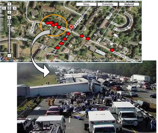
occur if the communication and the timely presentation of the ambulance movement are improper. If the speed and the direction of each moving object are known, indirectly their location in any arbitrary moment will be known. Practically, the locations can be obtained from GPS measurements (since every car is equipped with a GPS receiver). If the current location at time=t of each object is known, the decision-making can be adapted to the particular situation. For example, because accident occurred on the same road ambulance X stays, then as lifeguard, the responsible personal should provide help to victim in need. In this case, the ambulance X should help the victims with the same accident, and since the reaction will be very fast, it may be critical in saving lives.
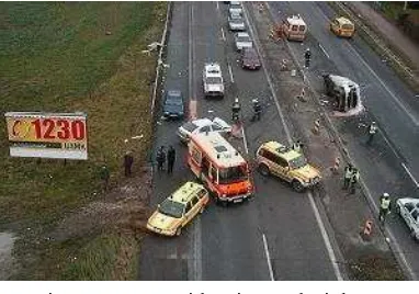
Figure 1: Car Accident in Road Highway
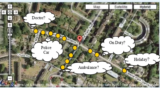
relevant factors that we translating to context in software usage, rescue guide application may provide and give a map that is relevant to salvage purpose only (of course base on the scope of their job position, or task and position at time=t (current location)) rather than present irrelevant information that not useful. For example in order to present a risk map, the application should can adapt the symbol of the map used based on the user's profile or system could adapt the type of information that more appropriate to each actors that involved in disaster management. For instance firefighters may need information (such as fire hydrant symbol, restricted area, etc.) presents in risk map are different with the risk map produced to ambulance (such as hospital symbol, etc.). For the worse case, by knowing context information, temporary relief from the public may be given. For example in the case of car accident as describe above, by knowing other personnel data (e.g. user's job) for each moving object involved in certain radius, relevant information can be sent to the relevant user's mobile device. For instance, the information about condition of victim and kind of assistance needed can be sent to the nearest 'doctor' mobile device from that location (Figure 3). However in this case, emotion and type of privacy needed by the user need to be considered too. Above scenarios shows that besides location and other parameters describing the movement, context information could take into consideration in application design.
Doctor?
On Duty?
Ambulance? Police
Car
Holiday?
This example clearly shows the importance of both 1) location of moving objects and 2) context of users. Moving object information may be captured using various techniques such as GPS receivers, network positioning for cellular in GSM/CDMA, wireless network, Bluetooth, etc. Location information of each moving object needs a frequent update. The more frequent update the more accurate we can get the information. Important context information for disaster management has to be also collected and maintained. Parameters defining context can be defined with respect to various factors. The next section elaborates on context in detail.
Figure 3: Context Information of Personal Data.
3.0 CONTEXT AND CONTEXT-AWARE TECHNOLOGY
research effort aiming to integrate context in application such as Context-aware Mobile Personal Assistant (COMPASS) (Mark, V.S., et al., 2004), Active Badge System (Want, R., et al., 2003), (Want, R., et al., 1993), Cyberdesk (Dey, A.K., 1998), Ektara (DeVaul, R.W., and Pentland, A.S., 2000), Mediacup (Gellersen, H.W., et al., 1999), TEA project (Gellersen, H.W., et al., 2002), Owl Context Service (Ebling, M., et al., 2001), Kimura System (Hansen, K.M., et al., 2001), Solar (Chen, G., and Kotz, D., 2002), Aura project (Garlan, D., et al., 2002) and Context Toolkit (Salber, D., et al., 1999).
The user brings the mobile device, will determine device location, and also user's location indirectly. User has to access to the device and its functionality. System conditions also depend on the device location. The location also defines the current temperature, which has a great influence on the battery life. Activities are always situated in space and time and differ for distinct user roles. Location and time restrict certain activities influence the possibility or meaningfulness of activities, or change their quality. Depending on the time locations can have a different meaning, importance or accessibility.
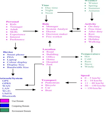
Figure 4 outlines the possible values of context entities and their relationships. Several context entities may give significant impact on maps visualization and representation. For example, the role could influence the task assigned in the instruction or command and also features presents on the map and their symbolization. The current activity and the user role influence the map content, map style, map graphic etc.
User Domain
Computing Domain
Environment Domain
Personal
· Kids
· Teenager · Adult
· Skills
· Experience · Interest
· Preference
Role
· Manager
· System Analyst · Doctor
· Decision maker
· Fire worker
Activity
· On duty
· Free time · After duty · Rest
· Meeting · Holiday · Walking
Location
· Road
· Building · Office · Home
· Hospital · Park
Network/System · GPS
· GPRS · WAN · LAN
· Wi-Fi · UMTS · Bluetooth
Device
· Smart phone · PDA
· Laptop · Colour display · Display Size
· Bandwidth Size
Time · Day time · Night · Noon
Weather · Winter · Spring · Summer · Autumn
Temperature · Hot · Cold · Rain · Snow · Windy
Speed
· 0 – 5 km/hr
· 6 – 10 km/hr · 11 – 40 km/hr
· 50 – 150 km/hr
· > 150 km/hr
Transport
· Pedestrian
· Bicycle · Car · Boat
User Domain
Computing Domain
Environment Domain
Figure 4: Possible value of context entities and their relationship. (Adapted from Reichenbacher, 2007)
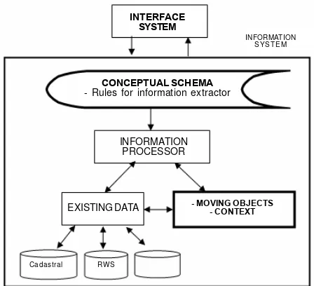
4.0 SYSTEM ARCHITECTURE
An abstract architecture of information system for disaster management in emergency response is shown in Figure 5 below. In our system architecture, DBMS plays a critical role.
INFORMATION S YS T E M
INTERFACE SYSTEM
CONCEPTUAL SCHEMA
- Rules for information extractor
INFORMATION PROCESSOR
EXISTING DATA - MOVING OBJECTS- CONTEXT
RW S Cadastral
Additionally, integrated queries on both spatial and non-spatial parts of features can be executed at database level. The spatial data types and spatial operations reflect only simple two-dimensional features, though embedded in 3D space. The next step is management of spatio-temporal data and mobile moving objects.
And Figure 6 below shows a DBMS as a central system, which provides a common interface between the data and the various front-end programs in the application. It also provides a central location for the whole data in the application to reside. The figure shows an example of DBMS and various applications that could involve in disaster. The focus of this research is primarily on the DBMS component.
Figure 5: Abstract Architecture of Information System for Emergency Response.
Figure 6: DBMS as Central System in Disaster Management System. New Application
Database Database
Management System Traffic System
Application
Police System Application
Fire Bridget System Application
5.0 SYSTEM REQUIREMENTS
In this section, we discuss the requirements need for building the context-aware moving object data management system for disaster management. We discuss challenges to the data model, indexing techniques, analysis and visualization of mobile moving objects with respect to a given context.
5.1 Data model
The data model is a backbone in this research. It acts as a framework and has a potential for fostering emergency response programs by guiding data management such as what data to be collected, formatted, stored, analyzing etc. especially under crisis condition specifically. From previous research, several problems in moving object database have been examined modeling and query language such as in (Sistla A.P., et al., 1997), (Erwig, M., et al., 1999) and (Forlizzi, L., et al., 2000). In emergency situation, each data spatial or non-spatial must be disseminated among organization and can be utilized rapidly by mobile technologies. However this efficiency of utilization is based on the structure and quality of data that serves the purpose of related organization. Thus data model provides practical template that simplify the integration of similar data sets at different scales.
Nowadays, various innovations in mobile computing drive many applications towards management of moving object's locations. Unfortunately, according to (Salber, D., et al., 1999), current Database Management System (DBMS) are not used to develop that moving object application. The reason for this is that in databases, data is assumed to be constant unless it is explicitly modified. Thus the management of moving object location especially in disaster is very complex and need some extend of data model in order to manage moving object data and combining with context data to make an appropriate decision and analysis task. Currently various research study on moving object and context, are done separately. Besides that, critical sets of capabilities that are needed by moving object database applications are lacking in existing DBMS such as moving object analysis, indexing dynamic attribute, uncertainty management of moving object and spatio-temporal operator, etc. This kind of issues need some proper data modeling to ensure that future application become a complete and useful application.
5.2 Indexing and updates
U
p
d
a
te
Accurate
Frequent
Q
u
a
li
ty
Cost
Accurate
Accurate
Cost Frequent
Accurate
increases a cost. The relationship between update, cost and accuracy can be shown as Figure 7. Where else index maintenance is important and must be take into account in Moving Object Database application in order to get the information with fast. There are two main issues related to index update, which are "when-to-update" and "how-to-update" (Ding, R., et al., 2003) that also could be a research question here.
Each moving objects has both spatio-temporal properties that represent the trajectory and non spatio-temporal properties represent the non-spatial data such as ID, phone number, name etc. In order to answer the question such as "show the nearest ambulance within 2 kilometer from location X", DBMS needs a Moving Object Database that could be storing, updating and processing queries trajectories of moving objects. Unfortunately, when the trajectory is update very frequently, it would impose a serious performance and wireless-bandwidth overhead, if not the answer to queries is not accurate at all or in other word is outdated. Ambulance information either in the field or not, could be known based on the speed ambulance involved (as context) in.
Figure 7: Relationship between Update, Cost and Accuracy
5.3 Reasoning and information analysis
disaster management, quick respond is the most important thing in order to give a high-quality care to the public (Zlatanova, S., D. et al., 2007). For example, lack of communication between actors on the field and decision maker in the office make the situation become worst due no monitoring device or tools that could give a suggestion based on real time situation. Advanced function that could be used at this moment is to get the information of distribution each responder unit by using visualization tools. In fact there is more than visualization that could be done by knowing the location of each responder. For example rather than visualization tools, addition service like real-time analyzing tools to get the shortest path based on traffic information (construction, traffic jam, accident etc), define the number of unit for each check point (based on the number of victims), define suitable hospital (based on victims condition), ad-hoc decision (based on uncertainty situation such as wind direction, river location (spatial analysis), etc) should be useful and helpful in decision making process. The system that can reuse the information in proper manner by doing related analysis might produce with better result. From the analysis task, a suitable suggestion and reasoning also could be a knowledge that can help decision making process in the future. Analyzing information could be more value if it can integrate with context-aware technology by proving an appropriate information to only who are really need the information based on their profile such as task, location, device, environment etc. Indirectly it prevent from distributed the information that are not related or not to be used by the user.
5.4 Interpolation and extrapolation
Although traditional databases are capable to manage location information, actually they do not enable interpolation or extrapolation . For example, the user needs to know which police officers were within one mile from location of emergency that occurred at 3 p.m. This kind of question can be retrieved if object (in this case, police officers) generate an update at 3 p.m. or earlier than that. If not then its exact whereabouts at that time are unknown. Where else in extrapolation problem, without update data and current work schedule, any future location has requested might impossible to retrieve. For example, user needs to know, which police offices will be closets to a criminal location within the next 20 minutes? These interpolation and extrapolation capabilities also be a challenge in this research in order to make the query more real like a human interaction each other to know about something.
5.5 Visualisation of result
moving objects. Most of the systems are also not adaptive to an elaborated context (as explained in section 4). However, to support the decision-making process, the systems should be able of visualizing results of analysis (overlays, predictions) with respect to the context of the user.
6.0 FURTHER WORK
This research aims at developing of conceptual framework for managing moving objects data and context data, which is expected to help greatly in decision making process for emergency response system. The research hypothesis is that a DBMS (with appropriate spatial schema, indexing techniques and operation) can drastically improve the effective management and analysis of moving objects. The integration of context information into the model should provide further flexibility in querying and visualizing of data. As a result the location awareness should be improved and enhanced with various spatial analysis (including predictions). The ultimate goal of the research is providing new tools for support of decision-making in disaster management. The next steps in this research are investigate what are the information that are really need by moving objects, what are the contexts (based on different user's roles) that can be analyst to be a useful information to emergency response systems and what kind of analysis (relating on user's need) that could be used in interpolation and extrapolation function. Using this approach we believe that the model to-be could aid and improve a decision making process especially in emergency situation
* Is the process of obtaining a value from a graph or table that is located between major points given, or between data points plotted. A ratio process is usually used to obtain the value
REFERENCES
Chen, G., and Kotz, D., "Solar: A Pervasive-Computing Infrastructure far Context-Aware Mobile Applications", Technical Report TR2002-421, Dept. of Computer Science, Dartmouth College, February 2002.
DeVaul, R.W., Pentland, A.S, "The Ektara Architecture: The Right Framework for Context-Aware Wearable and Ubiquitous Computing Applications", MIT Technical Report, 2000.
Dey, A.K., "Context-Aware Computing: The CyberDesk Project", In Proceedings of AAAI '98 Spring
Symposium on Intelligent Environments (AAAI '98 IE), 1998 [Online]. Available: http://www.cc.gatech.edu/fce/cyberdesk/pubs/AAAI98/AAAI98.html Dey, A.K., 2001, "Understanding and Using Context". Personal and Ubiquitous
Computing, Vol. 5, No. 1, p.p. 4-7.
Diehl, S. and J. van der Heide, 2005, Geo Information Breaks through sector shink, in: PJM van Oosterom, S
Zlatanova & EM Fendel (Eds.), Geo-information for disaster management, Springer Verlag, Heidelberg, pages 85-108,.
Ding, R., Meng, X., and Bai, Y., "Efficient Index Update for Moving Objects with Future Trajectories", In
Proceedings of the Eight International Conference on Database System for Advanced Applications 2003 (DASFAA'03), IEEE, 2003.
Ebling, M., Hunt. G., and Lei, H., 2001, "Issues for Context Services for Pervasive Computing", Workshop Middleware for Mobile Computing, Heidelberg, Germany, 2001.
Erwig, M., Guting, R.H., Schneider, M., and Vazirgiannis, M., "Spatio-temporal data types: An Approach to
Modelling and Querying Moving Objects in Databases", In Geoinformatica, Volume 3, Number 3, p.p. 269-296, 1999.
Forlizzi, L., Guting, R.H., Nardelli, E., and Schneider, M., 2000, "A data model and Data Structures for Moving Objects Databases", In Proceeding ACM SIGMOD International Conference on Management of Data.
Garlan, D., Siewiorek, D., Smailagic, A., Steenkiste, P., "Project aura: Toward distraction-free pervasive computing", IEEE Pervasive Computing, p.p 22-31, 2002.
Gellersen, H.W., Beigl, M., and Krull, H., 1999, "The MediaCup: Awareness Technology embedded in an Everyday Object", In Gellersen, H.W., (Editor) In HUC'99, LNCS 1707, p.p 308-310, Springer-Verlag
Berlin Heidelberg.
Gellersen, H.W., Schmidt, A., And Beigl, M., , 2002, "Multi-Sensor Context-Awareness In Mobile
Devices and Smart Artifacts", In Mobile Networks and Applications, Volume 7, p.p 341-351, Kluwer Academic Publishers
Using Spatial, Temporal, and Navigational Relationships to Support Multitasking and Background Awareness", In Proceedings of ACM Conference on Hypertext and Hypermedia, pages 14-18, ACM Press.
Mark, V.S., Stanislar, P., and Johan, K., 2004, "Context-aware Recommendation in the Mobile Tourist Application COMPASS", In Nejdl, W. and De Bra, P. (Editors), AH 2004, LNCS 3137, pp. 235-144,
Narain. A., "Disaster Management System: An Integrated Approach Using Satellite Communication, Education and Remote Sensing", [Online]. Available: http:// home.iitk.ac.in/~ramesh/narain.doc
Rahman, A.A., and S. Zlatanova, 2006, Pre-Hospital Location Based Services (LBS) For Emergency Management, In: E. Fendel, M. Rumor, (Eds.); Proceedings Of UDMS'06 Aalborg, Pages 11.49-11.57.
Richardson, B., 1994, "Socio-Technical Disaster: Profile and Prevalence", Disaster Prevention and Management, Vol. 3, No. 4, pp. 41-69,
Salber, D., Dey, A.K., and Abowd, G.D., 1999, "The Context Toolkit: Aiding the Development of Context- Enabled Applications", In Proceedings of CHI'99, Pittsburgh, PA, May 15-20, ACM Press.
Sistla A.P., Wolfson, O., Chamberlain, S., and Dao, S., "Modeling and querying moving objects". In Proceeding International Conference On Data Engineering 1997, pp. 422 - 432.
Su, J. Z., and Sauvola, J., "Towards a Conceptual Model for Contex-Aware Adaptive Services", In Parallel and
Distributed Computing, Applications and Technologies, PDCAT'2003, Proceedings of the Fourth International Conference On, pages 90-94.
Want, R., Hopper, A., Falcoa, V., Gibbons, J. 1992, "The Active Badge Location System", ACM Transaction on In System Volume 10, Issues 1, p.p 91-102, 2. Want, R., Schilit, B.N., Adams, N.I., Gold, R., Petersen, K., Goldberg, D., Ellis, J. R., and Weiser, M., 1993, "The ParcTab Ubiquitous Computing Experiment", [Online]. Available: http://systems.cs.colorado.edu/~grunwald/MobileComputing/ Papers/parctab.pdf
Winter, S., G.Iglesias, S.Zlatanova and W.Kuhn, GI for the public: the terrorist attack in London, Geoinformatics Magazine, October/November, 2005, pages 8, 2005. Zlatanova, S., A Proposed System Architecture for Emergency Response in Urban
Areas, Direction Magazine, `the Worldwide Source for Geospatial Technology, October 2005, 2005a.
Zlatanova, S., Crisis Designs, Geospatial Today, May-June 2005, Vol.4, Issues 1, pages 30-36, 2005b.
Zlatanova, S. and J. Stoter, 2006, The role of DBMS in the new generation GIS architecture, Chapter 8 in S.Rana&J. Sharma (Eds.) Frontiers of Geographic Information Technology, Springer, pp. 155-180