Lセ MMM NNNMM MMMMMMMMMM ..M セM MNセM ..
Geospatial
and Human-Dimensions
on Natura l Resource
Proceeding:
Geospatial and Human-Dimensions
on Natural Resource Management
ISBN 978-602-14437-0-5
Pusat PengkaJlan Perencanaan dan Pengcmbangan Wilayah (P4W) Center for Regional System Analysis Planning & Development (Crestpent)
Bogar Agricultural University (lPB)
Editor
Dr. Ir. Ernan Rustiadi, M.Agr Dr. Ir. Saba Baru s, MSc Dr. Satyawan Sunilo
Copy Editor
Galuh Syahbana Ind raprahast a Febri Sasliviani Puln Canlika
Layout & Cov er De s ign er Jam.:.aiS':"2
Cres.!pent Press
セ セS@ 3<oana ngsiang . JI. Raya Pajajaran, Bogor- 16 144, ...aKa 3arat. IneCHeSJ8 Phone/Fax: 025 1 8359072
Creslpent@2013
Geospat:iat and Human Dimensions
II on Natural Resou rce Manage me nt
(i
"
') I, Th'"
Eo "t th' Thi: sep. with SOUlthe <
"tw Sl(PO dala, ph(l!o problE aid de
Sustainable Rice Field to Assure Food Security in Garut Regency,
West Java
Bnbil
iセHャイオウL オ ャNN@$. 111111 11 .\ D.H. p[lJluju,l.:lillld Itt!. Trisaso ngkol.:2
I staff of Center for Region al sケセエ・ ュ@ Analys is, Planning and Development, IPB
I staff of Oepartment of Soil Science and Land Resources, Faculty of Agriculture, IPS
Email . Bababaru5@vahoo,com; phone/fax: 1622518359072
,\BSTHACT
Governm ent of Ga rut Regency has been prepa rin g to all ocate some spaces fo
r food security inte-grated within spati al pl anning as it is a mandate of the Nati onal Law No 41, 2009. There are severa l
cr iteria to de lineate foodproduction areas, including biophysi cal, socie an d economic factors.
However, detailed variables and criteria need further exploratio n an d exercises. This research 。ゥュセ@
to fi nd out appropriate factors and criteria to match local require ments, hence cootributing 10 food
$ecurily on either local or larger community areas. To achieve the goa ls, th is research employed
high resolution image ries SUCh ')S AlOS AVN IR2 and Quickbird ゥュ。ァ・イゥ・セL@ coupled wit h infr3$1(
uc-ture, land system, adm ini strative maps, and socia economic datase ts. Field datil were obtained
t hrough seve ral site su rveys whi ch were uti li ze d to va li date image interpreta tion and observe
deta il ed socioeco nomi C aspec ts of farmers. Several meth ods were imp lement ed such セウ@ remot ely
sensed basellne rice mapp ing, spatial anal)'sis using GIS too ls and stathtical anal}'sis. The reSul t showed th at appropriate variables used tc assess sustainable 10calloodpl""Oduction areas were
different In some distr icts Ikecomoton). Not all generic variables such as land suitability could be
implemented to identify ーセ、、ケ M ーイッッオエエゥッョ@ on all districtS. Different variables we re more inOuential
Ih an physica l aspe ct s. These included capacity of food supply for local demand and establishment
of environm ental friendly land manage ment. In terms of food security st atus,
the research indi-cated th at majori ty of districts secu red their local food req uirements and few of th em had excess
ric e production. At Gar ut Regency level, the aggregated data showed that Garut had some surplus
in paddy production. This information combined with demographic, paddy production and ot her
data implied that several
zones
of rice ヲゥ・ャ、セ@ required some protections either ill cultivated or inprotected area in the spatial planning. In addition, envitonmeola l virtue has 10 be included wit hin
agriculturalmn ing for better land protectiOJl in food security campa ign.
Keyword: Lo cal food sec urity. spatial anal ysis. unique land management, paddy ba lan ce. land zonation,
Introduction
The Government of Garu t Regency prepares to allocate land for food security in curr ent
revision of spatial plan <IS it is a m<lndatory 10 obey the National Law NO 4 1/ 20 09. To
support this task, it is necessary to mark out areas to ensure sustainable food deve lopm ent.
There are some constraints [0 delineate r ice fie ld in-Garut, including limited physically·
suitable and lega11y-acceptable areas for paddy cultivation and disaster prone due to
volca nic eruption, t sunami, landslide, and sloping land. Th e actual paddy fie ld s inventory has not been systematicall y developed yet. Therefore, ba.seline map of paddy production
area was known inaccurately. There are several criteria to define the sustainable rice field
area, including biophysicat socio and economic. factors. Some researches considered all
of these conceptua l cri teria to de marcate sustaina ble food producti on area, for instance
Chri stina (201 1) who delineated food regi on in West Java and Bachrv (2011) who mar ked
out land for sagoo in Pa pua. These explorations have utilized remote sensing and GIS and
have contributed Significantly supporting spatia l plan (Ba rus, 2011; Barus ei 01., 2011 ).
Since the law has quite pristine and has limited directives, apparent ly its implementahon
is uncertain. Methods and execu tions should be explored to di rect and put t he regulation
into operation properl y. Detail factors and criteri a are supposed t o be explored.
Many scholars such as Brown セ エ N 。 ャN@ (2009). Gamage et al. (2009), and .Boken et al. (2009)
reported various methods to map ir rigated land where i t was usua lly cu ltiva ted by paddy.
Ind eed. time series aspect was seemed to be the foc us of those resea rche s, since it WilS
carr ied out on a global map project. Therefore. most of them employed coarse 10 medium
spatial resolution of imageries for the purpose. Since Indonesian farmer is in averag!"
occupied small scale of land, high spatia l resolution of image should be employed.
The general purpose of this research is to find out seve!al appropriate factors arid cn te' ?
to match local requirem ents, hence contributing to secur e food suffiCiency for local ゥゥセZ@
larger com munities. The speCific purposes were (1) to develop actual paddy field ma p r
=.
its characteristics, (2) to analyze food security sta tus
of
district, (3) to delineate sust ,lI-セ]@paddy-production area regarding Ac t No 41, 2009, and (4J to develop contribur
:::-paddy fi eld on regional spatial plan (RTRW).
Geospatial and Human Dimensions
Method
The re we re two types of data empl oyed in this resea rch, i.e. primary and secondary
data . Some primary data comprised of paddy fi eld map (2011), paddy production and
socioeconomic aspec t of farming system, while the secondary data co nsisted of AlOS
image (2009), Quickbi rd (2010), infras tructure/irrigatlon map, land syste m (1990, scale
1: 25 0,000), draft of Spatial Plan of Ga rut Regency 20112025, administrative maps, and
some socioeconomic aspects of farme rs (20lO). The research was cond ucted on May
-July 2011, in St udio of Regional Info rmation of Crespent. IPB and field observation on June,
20 11 .
There are three methods implemented, including image interpretation to generate paddy
fie ld map thro ugh visual interpretation of high resolvtion imageries and the ァセッ オ ョ 、@ check;
GIS analySiS of severa l the matic maps such
as
land system, paddy fi eld map, irrigation map,sp<ltial planni ng map, an d oth ers; and statistical ana lySiS. The image ·interpretation
was
performed by using visual keys of interpretation such as to·ne or color, te)(ture, str uctu re,
associatio n, shape, e tc (Jensen, 2000). Quickbird image ry was urilize d as primary source
on image inte rpre tatio n to delin ea te paddy field, while AlOS da ta was used to complete
an d fill up some are as with seve re cloud covered. The result of interpretation wa s used
as paddy field baseline (sawah boku). Geographical analy:.is was carried out to develop
land capability map which was used as basic consideratio n to evaluate physical aspects of
paddy field. It was the n super imposed with themaric maps of irrigatio n, road and regiona l
spatial plan (RTRW ). The stage was important to ma tch recent pad dy field distribution
and fu ture a llocatio n oi paddyproduction a rea on セ trw Z@ Moreover, database resulted
from t he previous stage was then e mployed to ca lcutate land re quired to fulfill food
de mand. The food demand was estima ted for 25 years in the future from average of 10
yea rs population growth (197 1-2009) and paddy consumption according to mi nimum and
maximum of na rio nal and also loca l sta ndard. Some current (200S) paddy productivity
of ea ch sub·districts and cropping intenSity (indeks pertanoman) were considered to calculate paddy balanCing system.
Result And Disscussion
Actual paddy field and
characteristics
Gar ut is one of potential regencies on West Java for food production. It is because of its
physical characteristics coupling with strategic position due to proximity to Bandung, the
capital of West Java. Result of image delineation was total acreages whi ch then ca lled
as "'sawah baku" or standard area of food production. There were approximately 45 521
Hectares could be designated as the food production areas. Th e inve ntory was based o n
all scattered polygons identified and verified using ground data (appro)(imately 400 GCPs j
distrib uted in aU kecamaratls of Ga rut, indepth interviews with farmers, and supporting
da ta such as food area dynamics, and seasonal cultiva tion. The distribution of standa rd
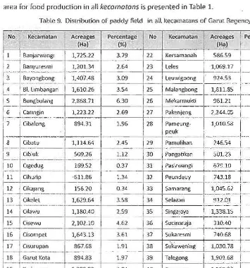
[image:6.611.49.404.258.638.2]area fO( food production in all
kecomotons
is presented in Table 1.Table 9. Distribution of paddy ReW in all keeamara ns of Garut Reyeru:y
Acrf!agflS Percentage
(Hal'
20 \::a(angpawotall 1,485.36
21 Karangten£ilh 308.09
(%)
No Acreages [' Percentage
(';). 1
ihセI@
. j
186
100 0:
Geospatial a nd Hum3fl Dimensions on Narural Resource Managemem
,
.'
•
.... MMセN@
I!'
-_.
-
_.
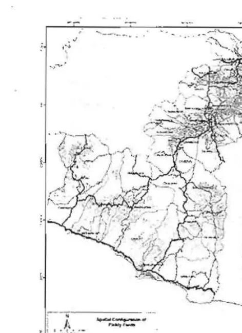
[image:7.613.85.321.46.371.2]-N セ@
Figure 1. Sra1 il l d ゥ セ| イゥ「ゥjャゥッョ@ o( paJdy fir ld in um.u rセァ エョH[ IG@ H FL」セョ@ spot)
Fro m the image proc.es.s.ing and GIS procedure. spatial dist ribution of paddy fi eld in Garul
could be delineated as. presented in figure 1. Apparently it is dis[(ihuted from North to So uth of Garut.
The figure shows that most of paddy fi eld located in the North part of Garut. The density
is q Uiet intense in the Nor th than in the Soulh . AppClrently. parc.el of the paddy field
was quite different between South and Nort region of Garut. In the North and Center of
Garut parcel size is quite bigger than in the North part. Spolial distrihulion of river is a lso denser in th e North and the Soulh. Paddy is highly consuming water during its growlh. Wate r availability is crucial and demanded to svppo rt the paddy-growth therefore dose area to rive r will always be preferred. Besides. considering the physical characteristics
of soils and its topographic, the North area is quie t flatter than South and considered more suitable to support paddy growth [he the South areas. It was then assessed the
--
n·· It- • • • _ , .. _ • .. If-." • • n ..;,-==-;:: ::: ::-.
セM BNセ@
..
セN""
.. .
...
..
•..
セ@.-
....
.
...
.
-.
Figurr 2. sーB i セ Q@disu'ioolion o( land tapability in g セ ヲ |ャャ@ JkgcllC)'
physical characteristics of those paddy area to gu ide food production area designation. Some variables including slope. la nd system and climate characteristics we re considered to dIrect the delineation. Map of land capability was gene rated from those variables and the spatial distribution is presented in Figure 2.
Figure 3.
Food security of Garut District
Food security is an important issue since it is related to human basic need. DiSCUSSing food security of Indonesian context means dealing with paddy. Garut has been stated as one of West Java.'s paddy-production area . To guara ntee whether it can be fulfilled self· suffiC ie ntly, baseline paddy fi eld and current land use must be delineated precisely. The previous part has discussed empirica Ipaddy fie ld of Garut Regency and some charac.tensnc; including cropping inte nsity and yield 01 each sub d istrict. From the delineated areas..:
Cieospatial and Human DimenSIons on Natural Resource Ma nagement
--- --- --- ---
--- ---
-
-i
1367J SU7 5Sl SM セ
-
..
A Nセ[[M M LL セ@..,.
""
セセ....
-.0141
;;:-.
..
!
!
XuセQ@ JlIX>.,"
M セセ セセ セ@
LセL@ LLセ
ToIfto"t Gセャ 。@
.m
MMBGMセセ Mセセ@
T.,o;on3':"1.,. i ャセ「UQ j@ 10318 lPS7 16591
セセセセM M MMM [Mセ M M
.
-LセL@ IS'l l '
11orotG"f
k^セ ャGャ。 ャ セ@ Gセョ@M セセM
"'..."""
I
('Sl71-,
..
,
セセ@
,--;;;:;; . L
].112m GセQ XHャャ[@ LS16J!1 _ Aセ セ M
In general, using the Indonesian ri ce-consumption sta nda rd both maximum and minim um,
local prod uction was less thim tota l de ma nd. Since the Guut standa rd not as much of
those, it apparently will be fulfill ed self suffidently. Indeed. ifwe examines in detail at each
sub district, it seems that some of sub districts will disco ntent its loca l demand.
Area for paddy sustainable development
Paddy sustainable development was dete rmined considering its physical charac teriStics,
curren t (existin g) condition of paddy area and production and loca l se lf-sufficien cy. The
result showed that appropriate variables used to delineate sustainabl e land fo r agricultura l
food was diHerent among sub-disl r icts. There was no generic variable to mark out paddy
fi eld in all districts, whereas different variables were more im port ant in such
sub-di stricts but apparently not in th e o thers. Capa city t o supply fo od for local demand and establishing friendly environmental land management came out t o be considered in some
cases. Table 2 shows 3 tYpe or prioritY area to ensure sustainable land for foods in Garut
Regency.
Priority of agri cultural land to support food security in Ga rut Re ge ncy, its acreages,
'cropping intenSity and production for every sub districts
,
-
,
o@
o rnatan Pad dy Acreages Cropping J>ilddV productio n Prio rity for IISr.B
I
iセ
- K,
{Hal intens ity (Ha) lani:l ',':..セ@ .L
_
NiNNNNNNNM セ MMM MMMGMZ ZI NZZNZZN ...,.,rwang'
M M セM
27,831.60
1.725.22
'"
1--
-resmi 1,101.34 24,S()6.20 I
ゥ@ ゥ セZ Z@
セ@
MM セ MI--
'"
_.
セ@iセ セ
__.
セ セ Aセ セァ@
i'
セ Lセ セセセ@
i ...
IP 2 _セ ZNHIW ⦅ セ ⦅セ
__...セ N⦅ N@ ⦅@
1i
4 61. Umba ngan 1,610 26 IP3 2S 613 60 115._._.'
b uセ セ「 オャセョァM
MM ャ@ G@ M [セ XVXョ
M
i
1;; 1
1.
Mセ
RL セ
MBM
- - ,
IG
Carl" g,n 1,123..22 IPl 8,960.80 3[2...
ciセセ@
89 0 1 L!P_,_ j
セ
NセッNッッ
nh,.L_
3Geospaoal and Hum<ln Dimensions
_
⦅
1..;.:. _...
Zセセ[ZZ
..
セ N] ⦅ [@ ᄋM Zセ[Z セ ⦅ ゥ M セᄋᄋ⦅ ZZ Z@
.. -[..
'NO, / ,Ke cam atim Paddy Acreage5 Cropping [ paddy prOdudion
ー イゥセイゥ iy@ ヲoイ@ 。XイN@
I
'-.,
-ィセ
G@
{Hal intensity (Ha) IanQ -'I
セッ セゥ e Mセ@ 」M セ Zセ TZセセ@
L
ZZ セ@
t-·
ZZ VセZ@ Zᄋセエ ]
:-=1
R:-
AMZセ セャ M ョ@ N@
-
:::;=!
Zセ M G@ M MZ Z[Z[Z@ セMセM MZM セ@
I
セ M
.
AM」ゥャ・ Gセ L@B@
. _.-
MM QセVQ YNセᄋ@
f·
IPlMM iQセ
M M G{ M
'·"3 /
セ Gセ NM N@
I
セ [[セw|j MGM _' h 1,13040 '-I
IP1 ᄋ セYNV W ZG⦅R P@ ;- - - ;. .. - -セ -セᄋ MQ -セ」G[[ G-セB@ ]-セエM
R セ Pセ K@
'"i_
ャセ Lセo
'_'_ _iイ ] G@ Nセ
__.,___
II ]6 (Isompel
I
1,(4) 13 LPl 18.52 1.10 3' .
-.. .. I ... ..
r "...
....... -セ ....... -セ
__
セ@ ⦅ 」N i⦅s|ャ セ セセセ⦅Q
ᄋ@
__
Xセ セセ
_ _セ⦅
N@
1_NQXNRYVNV
セ@
_ _セ
⦅ R
_ ____,• 18 ' Ga rut Kota 89483 IP3 20, t 76.80
j ,
';9[
セ、 オ [[[セ。 M M M エ M M セ Q LQYRP[MMM
ャ@
L
IP3
[セL Vs セNoo ᄋMᄋ@ MM M
1 -
-,__ .L. _ . . ... "'
.
f....'
{N セ
QセB セ。セ セセョャ
M MBG セTsウ
..
36⦅N ⦅セ@
IP=⦅セ@
⦅RW LセセY NR セ ⦅@
1 I21
t
k。 イ。ョ ァャ・ョァ
セィ@
308.09 IP3 13,682. 00セM
M M ヲ MM MM
1
t
T
セZR@ _ _ ・・ Gウ。 セセ ョセィ@ ..
_1
セ セZZ@__
1P3 _ Xセセセ __ セ@ _. .___セ⦅ N⦅ ... ._i::""/'
lセ セセセ ⦅@
... ___.;._ .⦅セ NPVY N セ_ ⦅@
!__
JP3_1_
N@ セ P NSsセNXセN@
1 : Rセ@ . lセャAキZ ァッ ッョァ@i
924':'3!
IP3 20,2 20A O 2I::
M セヲ [セ セエ`⦅j セ セセセセ@ Ni M M MZセZ@
ut ::::::
Mセ@ M Zセ] MMセ}@
ゥ⦅ セ X ⦅@ Mセ セセ セ セセァ セ セセ@ M ャM NNR GセM G@ KM セ
⦅
N
.
.,1
NRセZsNVP@
,
セ MM
.
セ セ ᄋ@
M
ZセZZ
⦅
..
__r=
M セ セ セゥ@
_._._
_.
11.<9' 80 BollS 40 _ _
i'
._ ._ 0'_ ._ _ -'3
2;0 ,
.-13,129 60
セ@
21
3'> SmgaJay<t ' J, 338 15
!
;;;;.0
-r--
13,99360 i
0;
.-ャヲエMMィセセ[
ZZ Mj M セZヲセ M
I :::
G@ [G セ[[RZM セセMMQ@
I "
h Ukawemng
!
1,030 78 IP3 21,8'>4.8O ! 2I
. . T o .. . ' . " ,.... ,..,
39
_.. _....___ ___.____.___. T __ _______ __, ________
Taiegonc 1,901.68 JP3 15.959.20I
3 I!
40 ..
",00,"",
l,lGS 23I '"
15.523.20i
11
iセl Zj セ[[Bセ]@
⦅@ MM MZZZセ
1 :::.
ZM NNSZセ[
___
j ..
セ ]セ Bセ@ ゥ@
[ _ _. __ _ 015,510.00 IP 3 7015,"91 .2 0 ! I
Spatia l distribution of the prioritize areas presents in Figure 2. Three types of sustainable
land for agriculture in Garut Regency セ 。|H・@ these following characteristks:
1. Type-1: actua lly paddy field, irrigated, 3 x cropping intensity (IP-3) and slope
<8 %
Remprk : The best and priority of the main area for paddy fields
2. Type·2: act ually paddy field, non irrigated, 1 x cropping intensity or 2 )( cropping
intensity, slope
8-15%
Remark : area of second priority and cropp ing intensity still should be imp roved with
technology
3. Type-3: actually paddy fi eld, non irrigated, all cropping intensity, slope >:0 15 %
Remark : area of third priority which is pote ntially landslide area, loca l ウ・ ャ ヲセウオヲヲゥ」ゥ・ョ」ケ@
issues and surplus of
rkeb" I""i,''-st'''"'
0--
-
.'
..
-,
-Figur., 3. Spalial di,u ibul ion of.usla;nabl., la ntl (or f()UtI and agri< ultu rc in G;arul Regency
Geospat ial and Human Dimensions on Natural Resource Ma<lilgemeni
[image:12.613.88.345.254.584.2]Land for susta inable food produc tion i n re lation t o spatial planning
Currently revised Garul District spatial plan consist of two different classes, i.e. cultivated
and pro tected areas. The protec ted area covetS almost 70 perCent of Garut areas. It was
comprised of forest prot ection area in vulnerable land, volcaniC halard area, tsunami
haza rd area, and landslide area. The cultiva ted region was composed of only 30 percen t
(ab{)ut 50,000 hal. Empiri ca lly, huma n activities including paddy. produ ction and
agro-forestry acti vities has esta blished at the protected area. According to the National Law No
41,2009, protection area should be excluded from human intensive utilization particularly
sett lement; bu t it allows limited agricuUural acti vities.
PCl ddy fie ld is considered as intensive agriculture, and it covers approximately 45,000 ha in
Garut re ge ncy and some of it distributed in the pro tection area . Onty sma ll percentage of
paddy fi eld, abo ut 10,000 ha, is located in the culnvated region. To protect area and ful fi ll
demand of ri ce then the paddy fi eld is supposed to
be
defined as sustainable food andagricult ural land. The definition means pro tecting the lands legally from encroachment
(conversion to other uses).
Sustainable agricultural land located in preserved areas has not been recognized in the
National law No 41, 2009. Nonetheless, numbers of people relied on the cultivation
system were numerous. Government should take into account the fact and 」ッョウゥ、セイ@
local community self-sufficiency since most of the locations were barely accessIble. The
importance of empirical phenomenon is (1) most of parldy fields along with ser.lement have
bee n es tab lished in the region before the new regulation released. (2) From environmental
perspective, th ese paddy fi elds has adapted to loca l condition and harmless loca lly il nd
globally, and (3) th e e)(istence of pa ddy production area in· some places is a mu!>! to ensure
local self-sufficiency.
Darabase of paddy field acreage combine with demographic, paddy production and o ther
physical data eventually produced several zoning o f paddy lands that should be pro tected
either laying in cu ltivated or in protected areas in t he regional spatial plan (Figure 4).
i
...
-.
__
...
,--
'
..
iic, - ,,-
"
_
'-'
....
,
'l:1l:I._ _
..
-
-fゥセイ・ T N@ Th.. Ktn lTjo of rustainible b.nd for food and agri('lllt\ltt to セ@
indudtd in セセエャ。j@ plan
Geospatial ancl Human Dimensions
Conclusion
Several important point ftom this researc.h are as fo llows:
1. Total actual paddy field area in G,1rut District is45 521 na, with 3 different types, vi .z .(al
type
1: paddy field with technical 1rrl ganon !.ystem, 3 times of harveSring. and suitable for paddy with size of 19 583 ha; (bltype
2; paddy field non-irrigated, 1-2 x harvesting time, and moderate ly suitable for paddy with size of 14 883 ha; and Ie) type 3: paddy fie ld non-irr igated, any harve!.ting rime, and no t !.uitable for paddy with size of 10 599 ha.2. The sta lus of food balance system of Garut is currently surplus 1190 000 tonl.. and appare ntly will be less l han demand for the next 2S yea rs. However, in more detai l
information, it reveals that 31 sub-districts will be surplus and 11 sub -districts will be deficit. The land dema nd to guarante e food security following local characteristics
w ill be 38 166 ha.
3. Using criteria of land for sustai nable paddy
I
food production as indicated in theNational law No 41,2009, there are many potential paddy 。イ ・セ@ can be developed for
sustainable food pmduction, but it has been modified physically. Apparentl y, some
areas have to be protected although it has 'less environmental suitable'.
4. Following the draft of Spatial Plan developed by Garut-Regency Government, there are
only 9 food security region proposed in spatlal plan which is located at the Cultivated Region. It repre!.C!nts small number of paddy field area (appr())(imately l O,ODO Hal,
and the rest areas proposed as land for food secu rity or reserve land for food security
area are located al the Preserved Areas. This empirical pnenomenon has not been
recogn i2ed and admin istrated in the current regu lation.
REFEllENCES
Saws, B. K. Gandasasmilol. 8. H. Trisaw ngko. D. ShiddiQ. L.S.lman dan R. Kusumo.. 201 1. P!.'m,)n'aalafl RuCtng D.lerah Gambul unlu lc PelkOOunan Kelapa Sawi, di PIovimi Riau dan Kalimantan Tell9ah. Prosidiog
Seminal Plrt3hutl Mapin XVII", RセQ@ Q L@ Universitas Diponegoro. SemiJfilng 8-9 Jun. 20 11
b。イオセ@ 8. 201 1. Penerllu./ln Oaya OUktlfl9 berduillkan Kemampuan lal\an: Ptnga/otrl(Jn lcajian vnluk ptYTlOnfoolon fU6"9di!.cell. Kabupaltn Gorol dan KoIo 8onjOtfJ)(J$in. PerlemUiln awal Kajiaf'l Oaya
Dukung uョァォオョYセョ@ Hidup Ptllau Sumatra disell'99arakan oIeh KLH-PP E Sumatra, Hotel Nyilduta, Pekanbaru, Riau, 15 AgU'Sl us 2011
SiKhri, S. 2011.ldentlt'ikil si 'ahan S<lgu dan pOlen si pema nfaala nnya seu .a be rkelanjutan di kabupalen Jayapu ril, Tes,s 52?S PWl, IPS(ti dak dipublikasikan)
Brown JF, MalM'l?ll S, ー セコ S. 2009. Map ping ilTigated landsacrou the United Slales Using MODIS. Sate llite
Imagl?fY. /n Thenkabail PS. l yoo JG, T uffal H, Birada{ CM. Remote Sensing 01 Global Croplands for food S«ul ity, CRC Press. Boca Ra ton, f lollda. Pp. 177-198.
Bokef1 VK,. Hooge nboom G, e 。ッ セs oヲQ@ GL. 2009. Applying PaUein Re<ognltl on to Sa te ll ite Data fOI Detec ting Irri gated lllnd s: ACase St udy for Georgi a, Unit ed States. InThenk ab<l il PS, lyon JG, Tuna t H. Bir<ldar CM. Remote Sensing of Globil! Croplands for Food 5e<u rity_ eRC Press. Boca Rato n, Florida.
pp.
-409-420.
Christina, D.R. 201 1. ldenl ilikasi !ahan potemlill U"luk meildukung USUlilli percnca" aa" !aha" pertanian pangan berkelilnj\ltan.Studi kiNIs di PfOVinsi Jawa Barat t セ ゥ ウ@ 52 PS PWL.1P8 (tidakdipub· likuikanJ
Chang, Kang ' lsung, 2002, Intlodoolon toGeographic lnfOl'mation S>,stem. McGraw Hill. 349p.
gセ ュN^ァ・@ MSON, Ahmad 1010, Tu rral H. 2009. MiIj)ping I(ligated Crops from landsat f.TM+ Imagery (or Het-e rogHet-enHet-eou s Cropping SystHet-em in Pakistan. (nThenkawil P$, lyon JG,Tu rtal H,. SiradarCM. RemO.h? SC'ming of Globa l Crop lands for Food s・\オイセケ N@eRC Press. Boca セエッョL@ f lorida. Pp. -421-440.. Jensen JR . 2000. Remo te sensing of the environment,. An Earth Resov{(e PelspectiYe. Pnmtice -Hail, Inc.
Upper Siiddle, New Jersey.
Longley, P.A., MJ. Goodchild, DJ . Maguire a nd OW. Rh lnd. 2005. Geographical Info rmation Syste ms and $( ience. 1'" edition. John Wiley and Sons. 5 18p.
UU No -4 1, t"hun 2009 lentang Perlindungan Pertanlan Pangan Berkelanju lan
Geospactal and Human Dimensions on NaturaL Resoun:e M<J.flagcmem
Hosted by P4W/CRESTPENT, Bogor Agricultural University
in collaboration with lAPAN, BAKOSURTANAL, MAPIN,
STPN, )KPP and supported by Faculty of Human
Ecology-IPS, Forum Tata Ruang, Common Indonesia Forum, HOP
Indonesia, and SLUAS JSPS Project, the 2011 International
Seminar on Geomatics & SAR (GeoSARNas) and Human
Dimensions on Sustainable Natural Resource Management
was successfully held at IPB International Convention Center,
International research communities
and
practitioners works
on
land and natural resource Issues communicating their recent
Crcstpont Press
Kampus
IPB
Baranal19siang. JI. Raya Pajajaran.Bogot-16144 . Jawa Bara\, Indonesia
PhoneIFax: 0251 8359072 E-MaiI;[email protected]