Disaster Management in Malaysia:
An Application Framework of Integrated Routing Application for Emergency Response Management
System
Safiza Suhana Kamal Baharin. Abdul Samad Shibghatullah . Zahriah Othman
Department of Software EngineeringFTMK, Universiti Teknikal Malaysia Melaka (UTeM), 76109 Durian Tunggal, Melaka, Malaysia
{safiza, samad, zahriah}@utem.edu.my
Abstract—Malaysia has experienced various disasters either natural or manmade disaster. One of the critical phases in Disaster Management System life cycle is response phase. In this phase, connectivity analysis such as a navigation service to help emergency rescue (ER) units reach at disaster area on time is necessary. Nowadays, commercial navigation system seems not appropriate to be used by ER units as they have different preferences. In addition, location information that is vital was not fully utilized in disaster management, especially in doing multi-task analysis. Thus, the real potential of GIS technology in managing spatial data including real-time (moving objects) data of ER units may influence the quality of the service. However, the services should be supported by a good data model. In order to eliminate inappropriate information, incomplete data, and overloaded information from Database Management System (DBMS) sent to the user, this paper will present the framework of integrated routing application for emergency response units embedded with context-aware.
Keywords-component; moving objects, context-aware, spatial DBMS, Emergency Response Management System, dataware house, route analysis
I. INTRODUCTION
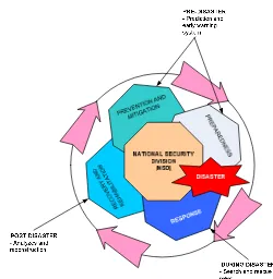
Disaster is incident that occurs in a sudden manner, complex in nature, resulting in a loss of lives, damages to property or the environment as well as affecting the daily activities of local community [4]. Disaster may happen anytime, anywhere and unavoidable. However, the impact and loses of disaster can be reduced through effective management of disaster information. The effective management here means provide a tool for Emergency Response (ER) units to reach at disaster area at the right time supported by appropriate information. Fig. 1 shows that disaster management system addresses 4 distinct phases, a) prevention and mitigation, b) preparedness, c) response, and d) recovery and rehabilitation. During disaster, time is critical. Information of moving object such as police cars, ambulances and fire trucks become important to drive the analyzing task including connectivity analysis. Although GIS application has been used in disaster management, it was designed for individual usage such as evacuation [15], and different phases of disaster such as mitigation and preparedness [5],[17] and monitoring/ visualization [8], or only for specific task [9].
Figure 1. Disaster Management System Life Cycle
Practically all ER services resort to use phone and paper maps for communication and collaboration in decision making process when they work on group. According to [3], spatial information can facilitate identification of impending disaster, provide directions to a disaster area or assist in developing logistics for ensuring assistance reaches at disaster area. Here a logical question has been arises - “whether it is possible to integrate spatial data and user preferences in navigation analysis to coordinate the multi-task/ role of emergency response units?“. The question arises as in response phase there are multiple emergency services such as hospital, police and fire department will take part [19].
II. RESPONSE PHASE AND CONNECTIVITY ANALYSIS
Based on the current approach, an ER unit has to guess, estimate and make decision without adequate information. This action will cost time, money, and lives [13]. In Disaster Management, an incident is reported to the Command Centre and multiple public agencies such as fire brigade, hospital, police and municipality are prompted and gathered to form a response team. All of these organizations have their own information and communication resources. Although there are an effort to standardize the communication technology (e.g. 999), the information system (e.g. application, database) of each organizations are not integrated [1],[16], and not allowed information exchange within/cross department. Thus, commander of each organization can retrieve information via their own control room only. ER
2009 International Conference of Soft Computing and Pattern Recognition
978-0-7695-3879-2/09 $26.00 © 2009 IEEE DOI 10.1109/SoCPaR.2009.144
733
2009 International Conference of Soft Computing and Pattern Recognition
978-0-7695-3879-2/09 $26.00 © 2009 IEEE DOI 10.1109/SoCPaR.2009.144
management requires collaboration and integration to facilitate complementary and coherent action by all partners to ensure the effectiveness of emergency management resources and execution of activities. Unfortunately, all of those criteria are rarely seen in current situation or even completely missing.
III. DISASTER MANAGEMENT IN MALAYSIA
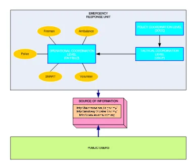
In Malaysia, the organization of Emergency Management (EM) and decision making process during a disaster could be divided into 3 different levels of scale, which are Level I, Level II and Level III [6] (see Table 1). In order to handle disaster effectively, a Disaster Management and Relief Committee (DMRC) are established at federal, state, and district level, which responsible on policy, tactical and operational coordination level. Figure 2. shows the flow of movement phase of ER units. Fig. 3 shows the Disaster Management in Malaysia. According to this perspective, we divide the user of this system into two categories, which are static users (People at Disaster Operating Control Centre (DOCC)) and moving users (People on the field or On Scene Command Post (OSCP)). There is less research focusing on operational level especially the management of ER units. Due to different preference of each ER unit’s agency, they tend to have their own data and system. However, each of the application are/may referring to the same data (e.g. road, location of accident, type of disaster, wind direction, land use). Providing the same information through different application is time consuming in term of data preparing, formatting and query as the info are not relevant and cannot be used anymore. The information that is retrieved from the application sometimes is dedicated for all ER usage including for general usage (e.g. use by public user) (Fig. 4). Currently much of the moving objects information is visualized as row data without processing. Various systems exist that allow the dynamic display of moving objects [14]. Most of the systems are not adaptive to an elaborated context [3],[10]. However, to support the decision-making process, the systems should be able to visualize results of an analysis with respect to the context of the user. This paper proposes a Framework of Integrated Routing Application for Emergency Response Management System that shows how Database Management System (DBMS) could aid in decision making process by providing appropriate information (route network) based on multi-user preferences (e.g. polices, ambulances and fire brigades).
TABLE I. DISASTER LEVEL IN MALAYSIA
Figure 2. Flow of movement phase of ER units
Figure 3. Disaster Management In Malaysia
Figure 4. Example of Different Role with Same Data Sources
IV. THE USE OF M OVING OBJECT DATA, LOCATION INFORMATION, CONTEXT DATA, AND NAVIGATION IN
EMERGENCY RESPONSE SYSTEM
Information preparation is the key to determine the successfulness of emergency rescue task to avoid confusion because of too many information or less information is provided. The application of NADDI by MACRES uses the
Disaster Level
Description
Level I Localized emergency : where local resources are adequate to manage the disaster response (DDMRC) Level II Emergency affected more than 2 areas and require aid
and support from outside. (SDMRC)
Level III Disaster is complex in nature and affect areas spanning over other states. (NDMRC)
sensor technology, GPS, GIS, Remote Sensing to get real-time data shows that the latest technology has been adapted in disaster management. However, the technology and resources was not fully utilized between organizations. For example, the location data, and other spatial data (e.g. flooded area) that has topological relationship cannot be analyzed due lack of tools and data management. Moreover, the moving point information is used only for visual monitoring and tracking. We believe that loses in disaster can be minimized if first responder reach at disaster location with fastest and supported by a ‘good’ analysis capabilities. Besides that, in order to send information to a right user and at a right time, user preference information on road network is useful as a context data. Although we have commercial navigation system like Garmin, Mio, and Tom Tom that can be used by rescue team [13] but it is still not enough and appropriate as it is not consider the context of the ER units. There are navigation applications capable to add blocking area and traffic jam info to re-routing based on dynamic changes as [7], unfortunately, less consideration had been given to the users of the system, who may use the information. Thus, we proposed to enhance the data model and application because public users have different preference or context compared to ER units. The application must not only focus on dynamic changes on the data but also it should take into consideration the dynamic changes of user preferences. Field of area include on this research is moving data, context and connectivity analysis (navigation).
V. MOTIVATION EXAMPLE
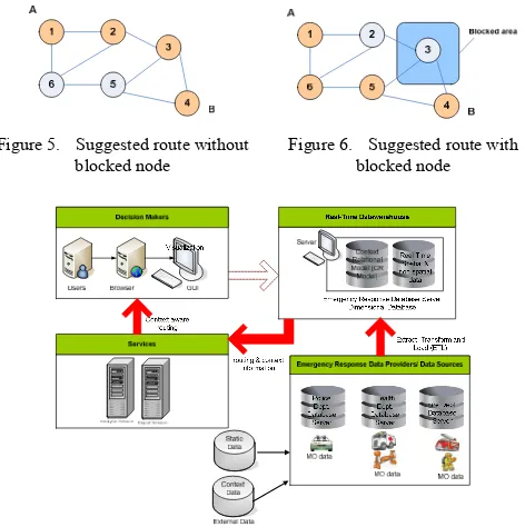
To illustrate the involvement and important of managing moving objects in road network combining with context-aware technology, let’s consider the following scenario. A burning house at location B was reported. An ambulance and fire truck has been assigned to that location. Let’s say that the fastest route to location B from current location (says A) of ambulance and fire trucks are through node 1, 2, 3 and 4 as shown in Fig. 5. However, node 3 is blocked by flood that can only be accessed by a vehicle exceed than 4 tones such as a fire truck (Fig. 6). Then the system suggests a new route (e.g. node 1, 6, 5, and 4) to ambulance and fire truck. Without applying context, the system does not take into consideration the user who requires that information. The system assumes that information is for everyone. From this example shows that the information of new route is not applicable and relevant to fire truck because the old route still valid for the fire truck since the weight more than 4 tones.
VI. OVERALL ARCHITECTURE
Fig. 7 shows the overall architecture of Moving Object and Context-aware DBMS for an efficient emergency response management. The application framework supports multiple time-critical users. With the proposed framework, heterogeneous information can be accessed by different users. The data originate from data model is transformed into a DBMS (e.g. Oracle). An entity on this model is
identified during requirement analysis. We divide our model into four packages which are user, network, event and route. The user package contains the information related to the user (as moving objects) such as user’s background (e.g. work schedule, jobs responsibility, and role), environment context (e.g. location, time, environment’s condition or weather) or social environment (e.g. traffic condition). The network represents the spatial data which contains geometry data (e.g. SDO_GEOMETRY in Oracle Spatial), the Event package contains the environment information (e.g. disaster type, location of incident and blocked area). And the last package is route which is results from connectivity analysis provided to the users. In order to provide the information to the right person, at the right place and on the right time, context information is applied. Stick to the definition of [2][1], there are 4 elements of context that important to this research; user identity, location, time and task [2]. This research applied the context-aware preference model that is Aspect-Scale-Context (ASC) model [18] and using data cubes in organizing the preference.
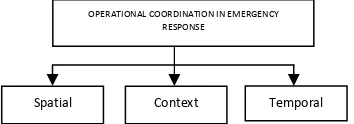
Spatial DBMS is a main component of this system, that allow maintenance of data (spatial or non-spatial) into multiple and integrated model (such as medical model, fire department model, police model, etc). Spatial DBMS manages moving object data model that contains simple feature of vector data. In order to represent a moving point, we refer to the moving object representation on [11]. We described our Moving Object and Context Data for Emergency Response Management System as Fig. 8. It is combination of spatial, context, and temporal data. There are two main services provided by data warehouse to the users which are analysis and reporting service that influence to the decision making process.
Figure 5. Suggested route without blocked node
Figure 6. Suggested route with blocked node
Figure 7. Overall Architecture
Some examples of such analyses should be useful and helpful in the decision making process are i) the shortest path based on traffic information (construction, traffic jam, accident, etc.), ii) determine the number of units for each check point (based on the number of victims), iii) define a suitable hospital (based on victims’ conditions, which might vary from non-stable condition, such as outpatient, to an ICU case caused decision should be changed on the way to the hospital), and iv) ad-hoc decision (based on uncertainty situation such as wind direction, river location, and implement proximity and position analysis, fencing services, navigation service, tracking service, [12]). The real users of this application are decision makers or Emergency Commander who locates in DOCC. We use the GIS to visualizing the location of ER units and we are using Oracle Map Viewer (MapViewer).
VII. FUTURE WORK AND CONCLUSION
This research aims at developing a conceptual framework of integrated routing application for emergency response management systems with focusing on management of ER units. This framework is expected to help greatly in the decision making process for emergency response systems. The research hypothesis is that a Spatial DBMS (with an appropriate spatial schema, indexing techniques, and operations) can drastically improve the effective management and analysis of moving objects in route analysis. The integration of context information into the model should provide further flexibility in querying and visualizing data. The next steps in this research are to develop dimensional data model at RTDW and integrate the context data and moving object data to be used in analyzing task. Using this approach, we believe that the proposed model could aid and improve the decision making process, especially in emergency situations.
Figure 8. Types of Data in Operational Coordination
REFERENCES
[1] A. Abdul Rahman, and S. Zlatanova, “Pre-Hospital Location Based Services (LBS) For Emergency Management”, In: E. Fendel, M. Rumor, (Eds.); Proceedings Of UDMS'06 Aalborg, pages 11.49-11.57, 2006.
[2] A.Dey and G.Abowd.,“Towards a better understands of context and context awareness”, In CHI 2000 Workshop on the What, Who, Where, When, Why and How of the Context Awareness, 2000. [3] B.I.J., Siljee, I.E. Bosloper, and J.A.G. Nijhuis, “A Classification
Framework for storage and retrieval of context”, K1-04 Workshop on
Modelling and Retrieval of Context, CEUR, Vol. 114, ISSN 1613-0073, 2004.
[4] C.Umar, “Disaster mitigation support and management in Malaysia”, unpublished, 2007.
[5] E. Tsui, “Initial Response to Complex Emergencies and Natural Disasters”, In Emergency Relief Operations, Kevin M. Cahill (ed.), Fordham University Press and The Center for International Health and Cooperation, New York, 32-54, 2003.
[6] I. Mohamed Shaluf and F. Ahamadun, “Technological disaster orevention – the case of Malaysia”, Disaster Prevention and Management, vol. 15, No. 5, 2006, pp. 789-792, Emerald Group Publishing Limited, doi 10.1108/09653560610712720.
[7] I.A. Musliman, A.Abdul Rahman and V.Coors, “Modeling dynamic weight for 3D navigation routing”, Proceeding of Map Asia 2007, 14-16 August 2007, KLCC, Malaysia.
[8] I. Rauschert, P. Agrawal, R. Sharma, S. Fuhrmann, I. Brewer, A. MacEachren, H. Wang and G. Cai, “Designing a human-centered, multimodal GIS interface to support emergency management”, paper presented at GIS’02, McLean, VA, November 8-9, 2002.
[9] L.D. Plessis, “A review of effective flood forecasting, warning and response system for application in South Africa”, Water SA, Vol. 28 No. 2, pp. 129-38, 2002.
[10] M. Sheleiby, M.R. Malek, A. Alesheikh, and P. Amirian, “Automatic Map Scaling in Car Navigation Systems Using Context-aware Computing”, World Applied Sciences Journal 3 (Supple 1): pp. 101-106, ISSN 1818-4952, 2008.
[11] M. Vazirgiannis and O. Wolfson, “A Spatiotemporal model and language for moving objects on road networks”, C.S. Jensen et al. (Eds.): SSTD 2001, LNCS 2121, Springer-Verlag Berlin Heidelberg pp. 20-35, 2001.
[12] R. Togt, E. Beinat, S. Zlatanova and H.J. Scholten, “Location interoperability services for medical emergency operations during disasters”, in P.J.M. van Oosterom, S.Zlatanova and E.M. Fendel (eds), Geoinformation for disaster management, Springer-Verlag Heidelberg, pp. 1127-1141, 2006.
[13] S.S. Kamal Baharin and N.Suryana, The importance of managing context and moving object data for emergency management systems. In M Sulaiman, NS Herman, E Kasmuri & S Salam (Eds.), International Conference on Engineering and ICT. Engineering and ICT: Meeting the challenges of advanced manufacturing, Melaka: Universiti Teknikal Malaysia Melaka, pp. 327-334, 2007.
[14] S. Diehl, and J. van der Heide, “Geo-information breaks through sector think”, in: PJM van Oosterom, S Zlatanova & EM Fendel (Eds.), Geo-information for disaster management, Springer Verlag, Heidelberg, pages 85-108, 2005.
[15] S. Pu and S. Zlatanova, “Evacuation route calculation of inner buildings”, in: van Oosterom, Zlatanova & Fendel (Eds.), Geo-information for disaster management, Springer Verlag, Heidelberg, pp. 1143-1161, 2005.
[16] S. Zlatanova, D. Holweg, and M. Stratakis, “Framework for Multi-Risk Emergency Response”, In: C.V. Tao and J. Li (Eds.); ISPRS Book Series, Volume 4, Advances in Mobile Mapping Technology, pages 159-171, 2007.
[17] S.A. Mohamed Hashim, “National disaster and remote sensing in Malaysia”, slide presentation at 2nd JPTM meeting, Bangkok,
Thailand, unpublished, 2006.
[18] T. Strang, C. Linnhoff-Poppien and K. Frank, “CoOL: a context ontology language to enable contextual interoperability”, in 4th IFIP
WG 6.1 International conference on distributed applications and interoperable systems (DAIS2003), Vol. 2893, pp. 236-247, 2003. [19] W. Xu, “Ontologies for Disaster Management Response”, Lecture
Notes in Geoinformation and Cartography, Li, J., Zlatanova, S., and Fabbri, A.G., (eds), In Geomatics Solution for Disaster Management, Springer Berlin Heidelberg, 2007.
OPERATIONAL COORDINATION IN EMERGENCY RESPONSE
Spatial Context Temporal