1st International Conference on Infrastructure Development, UMS Surakarta, 1 – 3 Nov 2013 ISBN 978-979-636-154-4
UNIFICATION OF ELEVATION DATUM FOR WATER RESOURCE
MANAGEMENT IN A RIVER BASIN
Irwan Syafri
Researcher on Experimental Station for River ResearchCenter for Water Resources
Ministry of Public Works
Jl. Solo-Kartosuro km7 Pabelan, Surakarta 57101 Phone.: (0271) 719429, Facs.: (0271) 716406
Abstract
In the water resource management of a river basin, elevation values used in various calculations, hydraulic analysis, river building planning, flood control, irrigation planning and others must refer to the same elevation datum. The most suitable elevation datum in the water resource management of a river basin is geoid, and the most suitable elevation system is orthometric elevation system. The unification of elevation datum consists of the determination of its point origin, tide observation, and the installation of elevation datum network. The point origin is a permanent peg called peil installed next to the location of sea surface tide observation.Minimum tide observation is 29 days. Elevation datum network is a benchmark, installed systemically along the left and the right sides of the main river, tributary,around the irrigation development area, dam plan location, and others. The calculation of the height difference between benchmarks is conducted using precise levelling method.
Keywords: unification, height, elevation, orthometric, datum, geoid, ellipsoid, origin point.
INTRODUCTION
Based on the Law of the Republic of Indonesia Number 7 of 2004 on Water Resource Management, the water resource management is defined as an attempt to plan, conduct, monitor, and evaluate the implementation of water resource conservation, the empowerment of water resource, and the control of water destructive force. In the article 4 of the Government Regulation of the Republic of Indonesia Number 42 of 2008 on Water Resource Management, it is stated that water resource management is implemented based on the policy of the management of water resource, river basin, and water resource management strategic plan.
River basin is an area unit of water resource management in one or moreCatchment Areasand/or small islands with the width less than or equal with 2,000 km2. The number of river basins in Indonesia based on the Decree of the President of the Republic of Indonesia Number 12 of 2012 on the Establishment of River Basin is 131, consisting of 5 cross-country river basins, 29 cross-province river basins, 29 nationally strategic river basins, 53 cross-regency/municipal area river basins, and 15 regent/municipal river basins.
In the water resource management of a river basin, the elevation values used in various calculation, hydrolic analisys, river building planning, flood control, irrigation planning and others must refer to the same elevation datum.Datum is the singular form of latin word data, which means things known, or considered, or assumed. Elevation is height of a point on a reference plane. Literally, elevation datum is datum of a reference plane used as basis for height calculation. Generally, there are 2 (two) reference planes used as basis of height calculation, namely geoid and ellipsoid. Geoid is equipotential plane of earth gravitational field coinciding with the mean sea level (MSL). Ellipsoid is an ellipse rotating on its minor axis. Based on the reference plane used, there 2 (two) elevation systems, those are physical elevation system and geometric elevation system,
Physical Elevation System
1st International Conference on Infrastructure Development, UMS Surakarta, 1 – 3 Nov 2013 ISBN 978-979-636-154-4
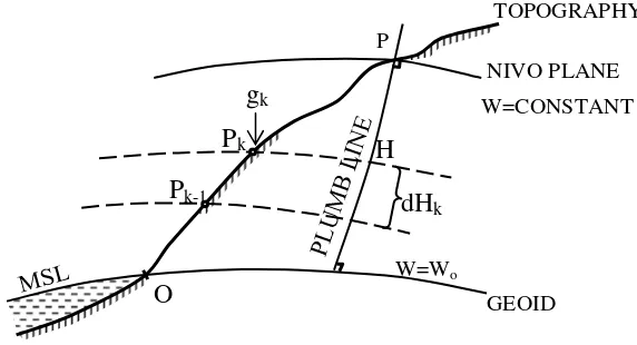
Figure 1Geopotential number
Potential through point P is WP and potential through point O is WO. If point O is a point located on geoid, and point P is a random point on earth, the potential difference of dW = WO – WP which is called geopotential number and notated as C, thus:
C = WO – WP = H
O
dH
g
.
…………(1)Since dH and g are continuous functions of a position, the integral of the above equation practically becomes:
Cij = =
j
k
k
dH
k
g
1
.
…………(2)where
g
k:½ (gk – 1 + gk)in general it can be written as: C =g.H or
H =
g C
…………(3)
The equation above is the formula for height. Number of geopotetsial C is measured in geopotential unit or g.p.u.
1 g.p.u. = 1 k.gal.meter = 1000 gal.meter Because g = 0.98 k.gal, C= 0.98 H
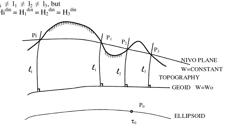
Next, by entering 3 (three) different g values in the above equation, it is then known 3 (three) types of physical elevation, namely dynamic height, orthometric height, and normal height.
Dinamic Height
In dynamic height, for the average value of gravity g, a standard normal gravity value for the corresponding area is taken, which is the closest normal gravity value to the average gravity value of the area. For global dynamic height, normal gravity value on latitude 45 is usually used.
o C Hdin
τ
= …………(4)
For Indonesia:
gal C Hdin
032 , 978
= …………(5)
Dynamic height datum is geoid, but dynamic height is not geometric distance between geoid and the corresponding point.
O
TOPOGRAPHY
NIVO PLANE W=CONSTANT P
gk
Pk
Pk-1
H
dHk
W=Wo
1st International Conference on Infrastructure Development, UMS Surakarta, 1 – 3 Nov 2013 ISBN 978-979-636-154-4 li l1 l2 l3, but
Hidin = H1din = H2din = H3din
Figure 2 Dynamic Height
From the equation above, we can formulate a dynamic height difference between point A and B as follows.
din AB
H
=H
Bdin−
H
Adin= 1 ( B A)
O
C
C −
τ
=B
A O
dn g. . 1
τ
= − +
B
A
O O O
dn
g )
(
1
τ
τ
τ
= + −
B
A O
O B
A
dn g
dn
τ
τ
din AB
H
δ
= nAB + DCAB …………(6)Where DCAB = number of dynamic correction calculated using the formula below.
DCAB =
−
B
A O
O
dn
g
τ
τ
…………(7)
dn is height difference of levelling measurement result.
Orthometric Height
Orthometric height of point (P) is geometric distance measured along plumb line between geoid and the corresponding point (P). This geometric height is the generally reasonable and widely used height.
Figure 3 Orthometric height TOPOGRAPHY
NIVO PLANE W=CONSTANT
GEOID W=Wo
ELLIPSOID
Pi P
1 P2
P3
P0
0 1
2 3
i
GEOID W=Wo HP
ORT g*
O
P
– !- -" "- #$-$ The formula of orthometric height is:
Hort. = *
g C
…………(8)
g* is average gravitational value along plumb line PPO. According to Helmert the value is:
g* : g + 0,0424 H
If levelling measurement between two points or more is conducted, height difference dn is obtained. To change levelling height difference to orthometric height difference, orthometric correction applies to the result of the levelling measurement.
The orthometric correction is calculated using formula as follows.
OCAB =
−
−
+
−
B
A
B O
O A A O
O B
O O
H
g
H
g
dn
g
τ
τ
τ
τ
τ
τ
* *…………(9)
If the levelling measurement is conducted in the relatively confined area, where nivo planes are considered parallel to each other, orthometric correction is usually ignored.
From the equation above, it is obvious that to calculate the orthometric correction, gravity data are needed. Therefore, in precise levelling measurement, gravity measurement is also usually done.
If the gravity data are unavailable, orthomethric correction can be calculated using theoretical gravity data with the formula as follows.
OC : -h ( Ø)* (0,0053 sin 2 Ø) sin 1” h : average height between two points
Ø : latitude difference between two points, positive if its direction is from equator to pole. Ø : average value is used
Normal Height
Normal height is theoretical, so it is never used for practical need. The form is as follows.
HN = C / * ………..(10)
* is average normal gravity along plumb line which can be measured as follows.
* = [1-(1+ f + m –2f sin2ø) H/a + H2/a2] ………..(11)
m = 2 a / E ………..(12)
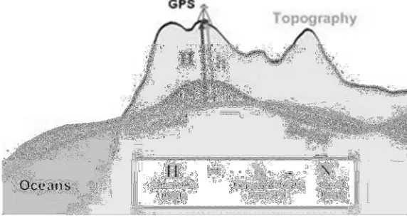
Geometric Elevation System
Geometric elevation system is the altitude system using ellipsoid plane. The height used is h height (geodetic height). The height of h toward referenced ellipsoid is calculated along normal line n’ which is through the point. Geometric elevation is obtained using satellite method, such as GPS. The illustration is shown below.
Figure 4 Geometric Height
– !- -" "- #$-$
DISCUSSION
Elevation Datum of River Basin
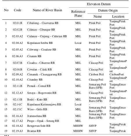
Up to now the elevation datum of river basins in Indonesia varies to one another. In table 1 below is the elevation datum of river basins in Java.
Figure 5 River basins in Java
No
Code
Name of River Basin
Elevation Datum
Reference
Plane
Datum Origin
Name
Location
1 02.01.B Cibaliung – Cisawarna RB MSL Priuk Peil TanjungPriuk Port
2 02.02.B Ciliman – Cibungur RB MSL Priuk Peil TanjungPriuk
Port
3 02.03.A2 Cidanau – Ciujung – Cidurian RB MSL Priuk Peil TanjungPriuk Port
4 02.04.A2 Kepulauan Seribu RB Local Priuk Peil TanjungPriuk
Port
5 02.05.A2 Ciliwung – Cisadane RB MSL Priuk Peil TanjungPriuk Port
6 02.06.A3 Citarum RB MSL Priuk Peil TanjungPriuk
Port
7 02.07.B Cisadea – Cibareno RB MSL Cilacap Peil TanjungIntanP ort
8 02.08.B Ciwulan – Cilaki RB MSL Cilacap Peil TanjungIntanP
ort
9 02.09.A2 Cimanuk – Cisanggarung RB MSL Cirebon Peil CirebonPort
10 02.10.A2 Citanduy RB MSL Cilacap Peil TanjungIntanP
ort
11 02.11.B Pemali – Comal RB MSL Semarang Peil
Baru (SPB)
TanjungEmas Port
12 02.12.A3 Serayu – Bogowonto RB MSL Cilacap Peil TanjungIntanP ort
13 02.13.B Bodri – Kuto RB MSL Semarang Peil
Baru (SPB)
TanjungEmas Port
14 02.14.C Kepulauan Karimunjawa RB Local - -
15 02.15.C Wiso – Gelis RB MSL Semarang Peil
Baru (SPB)
TanjungEmas Port
16 02.16.A3 Jratunseluna RB MSL Semarang Peil
Baru (SPB)
TanjungEmas Port
17 02.17.A2 Progo – Opak – Serang RB MSL
18 02.18.A2 Bengawan Solo RB MHHW SHVP TanjungPerak
Port
1st International Conference on Infrastructure Development, UMS Surakarta, 1 – 3 Nov 2013 ISBN 978-979-636-154-4 Port
20 02.20.B Madura – Bawean RB Local - -
21 02.21.B Welang – Rejoso RB Local - -
22 02.22.B Bondoyudo – Bedadung RB Local - -
23 02.23.B Pekalen – Sampean RB Local - -
24 02.24.B Baru – Bajulmati RB Local - -
Elevation datum of each river basin in Java varies. Some use Mean Sea Level (MSL), some use Mean Higher High Water (MHHW), and some others use local elevation datum. The river basins in Java which use MHHW are Bengawan Solo river basin and Brantas river basin. MHHW used in Bengawan Solo river basin and Brantas river basin is known as Surabaya Haven Vloed Peil (SHVP). Local elevation datum is obtained by determining and agreeing with the elevation value of an area, and the elevation value is then used as a reference of various elevation measurement. However, local elevation datum is not physically or mathematically defined, so it cannot be used as an elevation reference for all river basin areas in question.
There is no elevation datum of river basins in Java using ellipsoid. But, it must be remembered that the height toward ellipsoid (geometric height) obtained using GPS measurement is the height of a point toward the ellipsoid surface. Meanwhile, the ellipsoid surface is not equipotential plane of earth gravity, but just earth model without physical reality. On the other side, water flow is related to earth gravity. As a result, the geometric height cannot be used as the elevation system in water resource management of a river basin.
Unification of Elevation Datum
Water flow is related to earth gravity, and elevation datum which is equipotential plane of earth
gravity is geoid. Geoid coincides mean sea level. Consequently, the most suitable elevation system
used as elevation system in water resource management of a river basin is orthometric elevation
system.
For a river basin using orthometric elevation system, every time the height of the points in the
river basin will be measured, it must be started from the mean sea level. However, it will not be
efficient. Therefore, the unification of the elevation datum of the corresponding river basin is
conducted by disseminating the elevation values toward the mean sea level to all of the river basin
areas in order that all of those areas will be in one elevation system and there is an elevation
representation toward the mean sea level in all areas of the corresponding river basin. The initial
stage which is conducted in the unification of elevation datum of a river basin is determining the
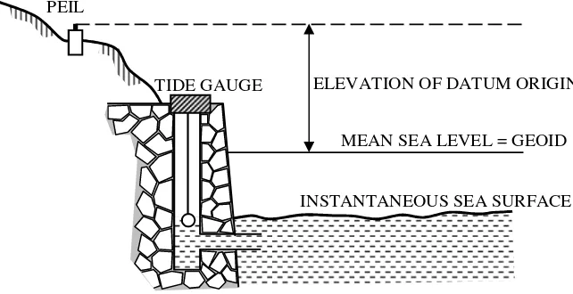
Origin Point. Physically, the origin point is in form of permanent peg made of reinforced concrete
construction usually called peil. Peil is installed near the sea level tidal observation location. The
height of this peil is determined toward the mean sea surface in the area. Mean sea level is
obtained by doing sea surface observation for 29 days. Then, a harmony analysis or other analyses
are conducted to obtain mean sea level. The peil height toward mean sea level equals the
difference of peil height from mean sea level.
Figure 6. Determination of Peil height toward Mean Sea Level. PEIL
ELEVATION OF DATUM ORIGIN TIDE GAUGE
MEAN SEA LEVEL = GEOID
1st International Conference on Infrastructure Development, UMS Surakarta, 1 – 3 Nov 2013 ISBN 978-979-636-154-4 To disseminate the elevation values toward the mean sea level to all areas of a river basin, the installation of elevation datum network is performed. The elevation datum network is bench marks (BM). The understanding of BM here is permanent markers with the dimension 20cm x 20cm x 120cm, installed along the left and right sides of main rivers, the left and right sides tributaries, around the irrigation development areas, around the dam plan locations, and other locations. The distance between the installed BMs on the left and right sides of the river is 1 km.
To reduce the distance between bench marks along the left and right sides of a river, the permanent pegs with smaller size of 10cm x 10cm x 120cm are installed. In practice, the smaller pegs are called control point (CP). All BMs and CPs are given numbers systematically. In order that each BM and CP save the elevation value toward the mean sea level, the measurement of height difference toward peil is conducted. The measurement method used is levelling method. In order to find out the height of other points toward the average sea surface, all we need to do is just tie it to the closest BM or CP.
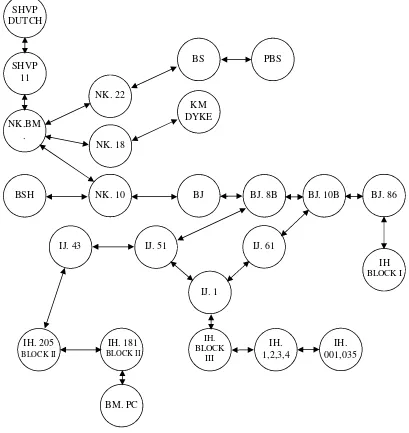
Figure 7 shows the example of the unification of the elevation datum of a river basin, in this case is Bengawan Solo river basin.
Figure 7 Unification of the elevation datum of Bengawan Solo river basin (data source: Monenco Company, 1984)
SHVP DUTCH
SHVP 11
NK.BM .
NK. 22
BS PBS
NK. 18
KM DYKE
NK. 10
BSH BJ BJ. 8B BJ. 10B BJ. 86
IJ. 43 IJ. 51 IJ. 61
IH BLOCK I
IJ. 1
IH. 205
BLOCK II
IH. BLOCK
III
IH. 1,2,3,4
IH. 001,035 IH. 181
BLOCK II
1st International Conference on Infrastructure Development, UMS Surakarta, 1 – 3 Nov 2013 ISBN 978-979-636-154-4 In Figure 7, we can see the stages of unification of the elevation datum of Bengawan Solo river basin, especially of lower solo area. SHVP is rob peil installed by dutch at SurabayaPort. SHVP peil refers to the mean higher high water plane. Peil SHVP is then used by Bengawan Solo Project as an origin point of the elevation datum. NK, BJ, IH, IJ, IH, KM, BSH, PBS, BS, PC, PL, SL, KTM, and JR are the names of bench marks installed gradually, and all have elevation values toward mean higher high water level. The unification of elevation datum of Bengawan Solo river basin has been conducted systematically. However, the implementation is not conducted in particular but together with other activities needing planning activity. The unification of the elevation datum of river basin should be well-planned, both in the datum used and BM dissemination location plan. The basis of the BM dissemination location selection is Implementation Planof the water resource management of the corresponding river basin.
CONCLUSION
The unification of elevation datum of river basin is conducted by disseminating the elevation values toward the same datum to all areas of a river basin to build the elevation datum network.
Elevation datum of each river basin in Java varies. Some use mean sea level, some use mean higher high water, and some others use local elevation datum.
Water flow is related to earth gravity, so the most suitable elevation datum in water resource management of a river basin is geoid, and the most suitable elevation system is orthometric elevation system.
The initial stage which is conducted in the unification of elevation datum of a river basin is determining the origin point.
The elevation datum network of river basin is bench marks installed along the left and right sides of main rivers, the left and right sides tributaries, around the irrigation development areas, around the dam plan locations, and other locations.
ACKNOWLEDGEMENT
I would like to extend my gratitude to Experimental Station for River, which has given facilities for me to complete this paper.
REFERENCES
Abidin, H. Z. 1995.Penentuan Posisi Dengan GPS dan Aplikasinya (1st ed). Bandung: PT Pradnya Paramita.
Syafri, I., Wuriyati, A. 1996. Kondisi Datum Ketinggian Wilayah Sungai di Pulau Jawa. Buletin Pusair No 23 Tahun VI. Bandung.
Minister of Law and Human Rights of the Republic of Indonesia. 2008. Peraturan Pemerintah Republik Indonesia Nomor 42 Tahun 2008 Tentang Pengelolaan Sumber Daya Air. State Gazette of the Republic of Indonesia Number 82 of 2008. Jakarta
Monenco Company. 1984. Vertical Control System Identification. Lower Solo Project (unpublished). Soeprapto. 1993.Pasang Surut Laut dan Chart Datum. Yogyakarta: Department of Geodetic Engineering of
Faculty of EngineeringGadjahMadaUniversity.
Joyosumarto, S. 1991. Pengantar Geodesi.Yogyakarta: School of Measurement Expert, Diploma III Program, Survey and Planning Department, PU-UGM.