accredited by DGHE (DIKTI), Decree No: 51/Dikti/Kep/2010 285
Research and Design on Navigation Electronic Map
System
Wanwu Li1, Lin Liu1,2, Honglei Dai1, Chang Qu1and Xiaotong Yang1 1
Shandong University of Science and Technology, Qingdao Shandong, 266510, China 2Island (reef) National Mapping Bureau of Surveying and Mapping Technology Key Laboratory
Qingdao Shandong, 266510, China e-mail: [email protected]
Abstrak
Makalah ini mengedepankan definisi baru peta navigasi elektronik berdasarkan konsep asli dari peta navigasi elektronik, perancangan struktur sistem peta navigasi elektronik yang berisi tiga bagian: peralatan perangkat keras, sistem data dan sistem perangkat lunak, dan menganalisa setiap bagian secara detail, pada bagian akhir paper ini membahas kerangka fungsional dari peta navigasi elektronik.
Kata kunci:navigasi, peta elektronik
Abstract
This paper puts forward the new definition on the basis of the original concept of the navigation electronic map, designs the structure of the navigation electronic map system which contains three parts: hardware equipment, data system and software system, and analyzes each part of them in detail, finally this paper discusses the functional framework of the navigation electronic map.
Keywords:navigation, electronic map
1. Introduction
The navigation electronic map is the result of the comprehensive application of the spatial information acquisition technology, the navigation and positioning technology, the computer technology, the database technology and the visualization technology in the field of mapping and it is the new form of the development of digital maps. Because it can provide the convenient and fast information for the people’s daily lives and travel, the navigation electronic map gets more and more wide application and has become an essential part of modern life. With the arrival of the Smarter Planet era, the navigation electronic map industry has become a new high-tech field with the rapid development, deeper application, and the increasing popularity. So the related technology research, the design and development of the system, the data updating and other researches of the navigation electronic map have become the hot spot of the contemporary cartography.
2. Research Method
2.1 Concept of navigation electronic map
navigation electronic map is the electronic map or data set which contains the geographic coordinates of space position, combines with the spatial orientation system and can lead the people or the vehicle from the origin to the destination exactly [4]”. The author puts forward the definition of the navigation electronic map become: “the navigation electronic map is based on the spatial database which highlights the related navigation elements, makes the specific design in the data model and data structure and takes the road network as the center to contact with the geographic framework information, the transportation information and the related points of interest information in order to serve for the moving target display, the traffic information query, the path planning and other navigation functions, so it is the floorboard of the electronic map which is suitable for specific navigation terminal and the related software”.
2.2 Structure of the navigation electronic map system
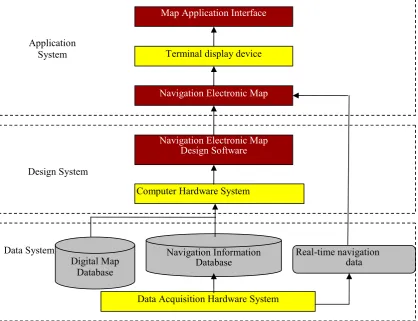
The navigation electronic map is the extremely important spatial information product in the map field. The constructions of data, hardware and software are forming a comprehensive system of electronic map which can provide all-around, real-time, dynamic navigation and information services to the public. According to the functions, the navigation electronic map system can be divided into three parts: navigation map data system, navigation electronic map design system and navigation electronic map application system [5], they are shown in Figure 1. The navigation electronic map system consists of hardware equipment, map data and software system from the point of view of structure.
Figure 1. Structure of Navigation Electronic Map System
2.2.1 Hardware equipment
The hardware equipment of the navigation electronic map system mainly contains three parts: the data acquisition hardware of the navigation map, the related design hardware of the navigation map and the terminal display and output device of the navigation electronic map.
1. Data acquisition hardware of the navigation map. The data acquisition of the navigation electronic map is divided into four types: the static map data acquisition, the dynamic positioning data acquisition, the real-time navigation information acquisition and the multimedia information acquisition, which separately corresponding to the four kinds of the hardware devices.
2. Related design hardware of the navigation map. They mainly refer to the computer and the affiliated equipments including the host, the displayer, the hard disk, the CD-ROM, the keyboard, the mouse and so on; some still include the graphics workstations.
3. Terminal equipment of the navigation electronic map. They mainly refer to the related display and output equipment to the electronic map data, text, graphics, audio and video data, including the computer screen, printer, plotter, vehicle navigation equipment, touch screen, portable mobile terminal and the voice navigation sound box.
2.2.2 Data system
The navigation electronic map is based on the navigation map database, so the main body of the navigation electronic map data system is the navigation database system. The navigation electronic map database is a comprehensive data set including the geometry information of the space elements, the basic property of the elements, the enhanced attribute of the elements and the traffic navigation information. The navigation electronic map data take the road network as frame, not only have plenty of the properties of the road network itself, but also connect a lot of social information and transportation information. The information is expressed in different detail levels, different comprehensive degree and different abstract degree, so there have a great amount of data.
2.2.3 Software system
The navigation electronic map software system refers to all software and programs that the design, production and application of the navigation electronic map need, including the equipment system software, the navigation electronic map platform software and the navigation electronic map application software. They are shown in Figure 2.
Figure 2. Navigation Electronic Map Software System Electronic Map Hardware
Design and Production Software Application and Browsing Software
3. Results and Discussion
3.1 Design of the navigation electronic map function
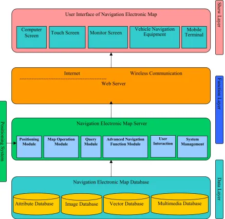
The function frame of the navigation electronic map is divided into three layers: the data layer, the function layer and the display layer. The functional layer is divided into the Web service layer and the map service layer, the structure is shown in Figure 3.
Figure 3. Structure of Navigation Electronic Map Function
The navigation electronic map contains six function modules; they are shown in Figure 4. The six function modules are the positioning module, the basic operation module, the query module [6], the advanced navigation function module, the user interaction module and the system management module. The function of each module is introduced below.
User Interface of Navigation Electronic Map
Computer
Attribute Database Vector Database Multimedia Database
Figure 4. Navigation Electronic Map Function Module
4. Conclusion
This paper puts forward the new definition on the basis of the original concept of the navigation electronic map, and designs the structure of the navigation electronic map system. This structure is more effective than before. This paper also presents the functional framework of the navigation electronic map which is more detailed and scientific. Global navigation electronic map industry developed from the end of 1990s, after 10 years of growth, it is still in high speed development stage now. The development trend of navigation electronic map in our country is as follows: (1) The popular map application era is coming;(2) Navigation electronic map market will be further concentrated;(3) The service content of Navigation electronic map will be further deepened;(4) The electronic map industry based on beidou navigation system will develop rapidly.
Acknowledgments
Fund Protect: Supported By the Natural Science Foundation of Shandong Province (ZR2012FM015); Supported By the Key Laboratory of Surveying and Mapping Technology on Island and Reed, State Bureau of Surveying and Mapping, China (2012B08, 2011B11); Supported by Special Project Fund of Taishan Scholars of Shandong Province.
References
[1] Ping Gao, Yongqiang Ning. Visualization Status Analysis and Prospect of Navigation Electronic Map Product. Bulletin of Surveying and Mapping. 2010: 404-426.
[2] Ying Song, Qingquan Li. Fusion Expression of Real-Time Traffic Information and Navigation Electronic Map.Geomatics and Information Science of Wuhan University. 2010; 35 1108-1109
[3] Cunhong Hua, Qingyun Du. Comprehensive Application System of DigitalMap: Formation and Development. Bulletin of Surveying and Mapping. 2004; 56-58
[4] GB20263-2006 Navigation electronic map. Basic requirements of security processing technology [5] Nasaruddin, K Munadi, M Dirhamsyah, D Yuliansyah. A Web-based Geographic Information System
for Aceh Natural Hazards.TELKOMNIKA. 2011; 9(1): 89-98.