DEFORESTATION AND ROCKY DESERTIFICATION PROCESSES IN GUNUNG SEWU
KARST LANDSCAPE
(
Proses Deforestasi dan Rocky Desertifcation di Landskap Karst Gunung Sewu
)
ARZYANA SUNKAR
Division of Protected Area Management
Department of Forest Resources Conservation & Ecotourism, Faculty of Forestry, Bogor Agricultural University Kampus Darmaga Bogor 16680, Indonesia
Received 13 September 2008/Accepted 7 November 2008
ABSTRACT
Kerapuhan suatu kawasan karst merupakan dasar terbentuknya rocky desertification, yaitu proses yang merubah kawasan karst yang sebelumnya ditutupi oleh vegetasi dan tanah, menjadi landskap batuan hampir tanpa vegetasi dan tanah (Yuan, 1991: 1). Pada kenyataannya, hal ini diperparah dengan pertumbuhan populasi manusia dan meningkatnya deforestasi yang menambah tekanan terhadap kesuburan tanah seperti yang terlihat di kawasan Karst Gunung Sewu. Studi pustaka yang meliputi analisis isi (content analysis) dari bahan-bahan sekunder diperlukan untuk mengumpulkan data serta informasi yang terkait dengan sejarah perubahan landskap Gunung Sewu. Selain itu, data dan informasi juga dikumpulkan dari pengamatan langsung di lapangan serta wawancara dengan kelompok petani. Hasil analisis menunjukkan bahwa telah terjadi perubahan landskap di kawasan Karst Gunung Sewu yang terkait dengan budaya membuka lahan untuk bertani.
Di Gunung Sewu, populasi manusia yang berlebihan menyebabkan meluasnya pembukaan wilayah hutan untuk areal pertanian serta pemukiman. Pembukaan lahan yang terus menerus akibat deforestasi meningkatkan erosi tanah sehingga tutupan vegetasi maupun tanah menurun yang diikuti oleh meningkatnya singkapan batuan karst.
Keywords: deforestasi, rocky desertification, Gunung Sewu, karst
INTRODUCTION
Throughout their history, people have put increased pressure on the carrying capacity of the environment to meet their needs. With the development of cutting tools and use of fire, the rate of deforestation increased. As the population increased still further, forests were again burnt to clear land for agriculture and permanent settlements.
Landscape changes are apparent in Gunung Sewu Karst in the Province of Yogyakarta. The resultant landscape portrays the history of the area which is associated with the evolution of food production system.
Urich and Reeder (1996) prove that type and intensity as well as the date of forest clearance are critical to the success of regreening. It is therefore important to identify the historical changes that have taken place and the processes that have contributed to these changes.
RESEARCH METHOD
The location of the study was Gunung Sewu Karst, to be specific in Tepus, Ponjong and Rongkop Districts. Content analysis of secondary materials was necessary to collect data and information on the history of the deforestation of the area. These materials were collected mostly from published university research and reference
books. Field observations and interviews were also conducted to obtain visual and oral evidence of the quality of the environment. Some interviews with several farmer groups were also conducted.
RESULTS AND DISCUSSION Conversion of Hilltops for Cultivation
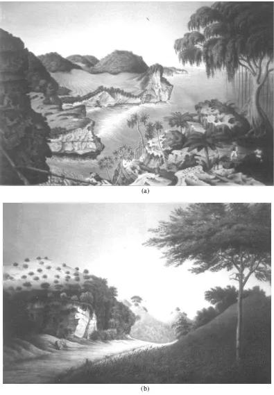
(a)
(b)
Source: Drawings by Jughuhn (1850)
Figure 1 illustrated that there is a clear difference between the two locations. The location of Figure 1a is inland and away from the coast. As can be seen, the forest on the inland hilltops was cleared and only patches of trees left standing. The cleared hilltops between Semanu and Bedoyo show evidence of deforestation up to the top of the hills and these must have been cleared for conversion to crop plantation, since these villages are located closer to the Wonosari area. Areas near the coast of Rongkop, showed dense vegetation covering the hills suggesting that in 1850 the karst cones were still forested, though the low-lying areas had been converted to cultivation.
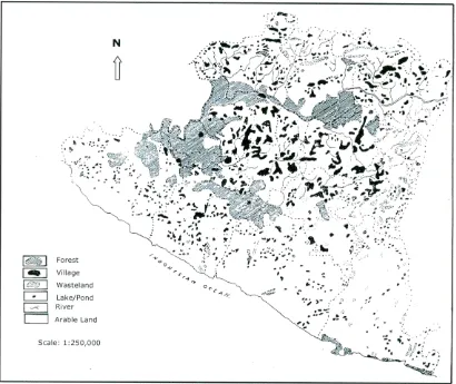
Although the coast offered easy access, the southern coast offered few safe anchorages and this probably explains why the hilltop forests retained their forest cover. Another reason might be because the residents near the coast had an alternative source of income from swiftlet nest collection. Thus they only cultivated the low-lying areas, whereas inland, the inhabitants had no alternative but to cultivate every possible inch of land. Early in the 1960s, a small scattering of forest remnants was still to be found near the coast of Rongkop and on the western side of Gunung Sewu (Nibbering, 1991a). This is evident on the land use map for 1969 (Figure 2).
Source : Khan (1963)
Figure 2. Land Use Map of Gunungkidul in 1969
Junghuhn’s observations on the condition of Gunungkidul led him to believe that the human impact was still low (Nibbering, 1991a), and the figures of the 1838 Statistics of Yogyakarta Residencies suggest Gunungkidul and Gunung Sewu were both cultivated only sporadically and in small patches (Nibbering, 1991a). However, Jughuhn also noticed luxuriantly growing groves typical of a tropical
savanna, which Nibbering (1991a) interpreted as having developed under regimes of man-made fire. This meant that the area was already experiencing human impact before it was brought to permanent cultivation. Fire was also used to burn areas under established shifting cultivation.
standing forest. It must also take into account the effect of physical processes associated with fire. The impact of fire on soil fertility is significant as it open up forest, which in turn exposes the soil. When cleared land reaches the hilltops, leaching of nutrient occurs more rapidly, and soil fertility declines rapidly. Thus, despite Jughuhn and Nibbering’s conclusions, the human impact must have been more substantial than it appeared. Meanwhile, economic activity in the coastal forests focused on the collection of bird nests. In this sense, the human impacts referred to by Nibbering (1991a) must have had an impact more in terms of hunting/gathering or “agriculture”.
About two decades later, Danes (in Nibbering, 1991b) observed that nearly all valley floors in Gunungkidul were
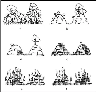
cultivated (Figure 3), and that more land was needed for food because hillsides were starting to be cultivated although more land were still available near the coast. Finally, by the 1930s, valley floors were under permanent cultivation and the slopes were alternately cultivated and fallowed. In the late 1930s, the southeastern part of Gunung Sewu had relatively more trees consisting of non-teak forest (Instituut voor Volksvoeding in Nibbering, 1991a), most of which were cut in the 1940s and 1950s due to the economic stress experienced at that time (Nibbering, 1991a). The process of conversion of hilltops into cultivation is summarised in Figure 3 below.
Source: (a - d) Dames, Jughuhn, Veth, Danes (in Nibbering, 1991a), (e) Nibbering (1991a), (f) field observation (1998)
Figure 3. Hilltop Deforestation Process(a) Original vegetation: mixed evergreen-monsoon forest (ca. 1500?); (b) Woodland-savannah vegetation (ca.1835); (c) Intensifying agriculture; (d) Deforested and degraded land (ca. 1960); (e) Fields planted with regularly pruned trees (ca. 1990); (f) Fewer trees on hillsides (ca 1998)
Deforestation of Teak Forest
Teak replaced the natural vegetation of Gunung Sewu, but as with the natural vegetation, teak plantation also underwent intensive deforestation during the Japanese occupation. In 1942, the Japanese attempted to control the economy of Java. At the beginning of the occupation, plenty
planting by the Dutch which allowed the growth of mature trees that produced big logs.
The Japanese occupation caused great distress for large parts of the population. The occupants requisitioned rice, cassava, cattle and manpower from all over Yogyakarta. There was a great shortage of food (with some people starved to death), and clothing, and other commodities were scarce. As Sato (1994) notes, textiles became extremely difficult to obtain after 1943 (Sato, 1994). Field interviews with elderly farmers highlight the great stress generated during the Japanese occupation, although it lasted only a short time (1942-1945). That generation of farmers stated that, “Lewih sekeco jaman londo ketimbang jaman jepang. Jaman jepang meniko angel pados kangge nedi. Kedah nanem kapas. Beras mniko kagem daharan jepang” (“the farmers were forced to cut down all the teaks and grow cotton instead, while rice were grown to feed the Japanese military”). Due to the unsuitable climate, cotton production failed miserably, and there was a serious shortage of looms (Sato, 1994).
During the war, marine and mining transportation were vital assets. Teak was needed for the hulls of boats and
as fuel for steam locomotives. Before the war, locomotives in Java were fuelled with teak in flat areas and with coal in sloping areas. Nevertheless, Sato (1994) said that none of the original planners had any experience in mining, thus the locomotives had to rely on teak. In the pre-war years, between 6,000 and 6,500 hectares of teak were logged per annum (Sato, 1994). The railways annually consumed 300,000 tonnes of teak. About 450,000 tonnes of teak were required between July and December 1942 and staffs were dispatched to Central and East Java to secure teak (Sato, 1994) probably to Gunung Sewu and Pacitan since those are limestone areas providing good habitat for teak.
Demand for teak in 1943 increased to 950,000m3, and to 1,380,000m3 in 1944; of this 180,000m3 was imported from Borneo. This highlights the fact that teak had become scarce in Java. Although reforestation intensified, the growth rate could not match the rate of logging. The Japanese soon exhausted teak, and in early 1944 they had to resort to other timbers (Sato, 1994).
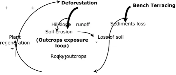
Overall, the deforestation process in Gunung Sewu can be summarised on the feed-back diagram as pictured in
Figure 4. Causes and Effects Mechanism of Deforestation Process in Gunung Sewu
Rocky Desertification
Lack of vegetation due to years of deforestation promotes soil loss. Based on his analysis of the soils of Gunung Sewu, Dames (1955) described the area as severely eroded. This led him to term Gunung Sewu as “the most degraded and poorest limestone hills in Indonesia” (p.79).
Peninsula that it has been transformed into a karst desert (White, 1988). This severe form of land degradation has also occurred widely in the Mediterranean basin including
southern France, Italy and the Dinaric Region (Gams et al., 1993). This area has had the longest period of intensive human impacts of any karst terrain.
Figure 5. Process of Rocky Desertification
Yuan (1997, 1993) observed that in the bare karst of Guizhou Province in China, rocky desertification has resulted in increased annual floods, which have further reduced regeneration of trees and led to the progressive impoverishment of the local residents. In Gunung Sewu, rocky desertification has occurred as a result of years of serious erosion. This emphasises the vulnerability of karst to soil depletion in the wake of deforestation.
CONCLUSION
The decreasing carrying capacity of the land reflects the increasing human impact on the availability of Gunung Sewu resources. Pictures of the past of Gunung Sewu clearly show that even the early days when people started moving to Gunung Sewu, the area had already suffered some loss of habitats especially on the hilltops. The environmental risk of opening up forest in karst land is even higher as the soil cover is relatively thin and easily eroded due to loss of support by roots.
In Gunung Sewu, the problem of over-population led to the extention of farmland by forest clearing. The effects of new cultivated terraces and the creation of more and more, even extremely tiny, cultivated plots between the karren on steep slopes, causes progressive deforestation and increasing exposures of karren (rocky desertification) as a result of the erosion of soil following intense agricultural (1993). Environmental Change and Human Impacts on
the Mediterranean Karsts of France, Italy and the Dinaric Region. In P. W. Williams (Ed.), Karst Terrains: Environmental Changes and Human Impacts (pp. 59-98). Cremlingen-Destedt: Catena Verlag.
Jughuhn, F. W. (1850). Java: Deszelfs Gedaante, Bekleeding en Inwendige Structuur. Amsterdam: P. N. van Kampen.
Khan, M. H. (1963). Gunung Kidul. Indonesian Journal of Geography, 3(4-6), 47-60.
Nibbering, J. W. (1991a). Hoeing in The Hills: Stress and Resilience in an Upland Farming System in Java. Unpublished PhD Thesis, Australian National University, Canberra. Conservation in an Upland Agricultural Catchment in West Java, Indonesia: A Hydrological Approach in a Socio-Economic Context. Unpublished PhD Thesis, Vrije Universiteit, Amsterdam.
Sato, S. (1994). War, Nasionalism and Peasants: Java under the Japanese Occupation 1942-1945. Sydney: Asian Studies Association of Australia in Association with Allen & Unwin.
Van Dijk, A. I. J. M. (2002). Water and Sediment Dynamics in Bench-Terraced Agricultural Steeplands in West Java, Indonesia [Electronic Version]. Retrieved 7 September 2002 from Http://www.geo.vu.nl/~trend/ c2.pdf.
Whitten, T., Soeriaatmadja, R. E., & Afiff, S. A. (1996). The Ecology of Java and Bali. Halifax: Periplus Edition Limited.
Yuan, D. (1993). Environmental Change and Human Impact on Karst in Southern China. In P. W. Williams (Ed.),
Karst Terrains: Environmental Changes and Human Impact. Catena Supplement 25 (pp. 99-108). Cremlingen: Catena Verlag.