i
PJP/2010/FTMK(1D)S684
REMOTE SENSING IMAGE CLASSIFICATION
USING SOFT COMPUTING APPROACH
DR MOHD FAIZAL ABDOLLAH
OTHMAN BIN MOHD
PROF DR. HJ. SHAHRIN BIN SAHIB@SAHIBUDDIN
PROF DR. NANNA SURYANA
FAKULTI TEKNOLOGI MAKLUMAT DAN KOMUNIKASI
UNIVERSITI TEKNIKAL MALAYSIA MELAKA
ii
DEDICATION
I would like to say thank you for those who involves for helping me to complete this project. First of all, I would like to say thanks you to all grants members who helps to accomplish this project. Without their helps, we will not able to complete this project.
iii
ACKNOWLEDGEMENTS
We would like to express our appreciations to Universiti Teknikal Malaysia Melaka on the award of the short grant fund as to complete our research on Remote Sensing Image Classification Using Soft Computing Approach.
iv ABSTRACT
Mangrove forest is an important costal ecosystem in the tropical and sub-tropical coastal regions. It is among the most productivity, ecologically, environmentally and biologically diverse ecosystem in the world. With the improvement of remote sensing technology such as remote sensing images, it provides the alternative for better way of mangrove mapping because covered wider area of ground survey. Image classification is the important part of remote sensing, image analysis and pattern recognition. It is defined as the extraction of differentiated classes; land use and land cover categories from raw remote sensing digital satellite data. One pixel in the satellite image possibly covers more than one object on the ground, within-class variability, or other complex surface cover patterns that cannot be properly described by one class. A pixel in remote sensing images might represent a mixture of class covers, within-class variability, or other complex surface cover patterns. However, this pixel cannot be correctly described by one class. These may be caused by ground characteristics of the classes and the image spatial resolution This project was about the unsupervised classification for satellite image by using fuzzy logic technique. In this project, the method of unsupervised classification was implemented as compared to supervised classification. Nowadays, many situations on this earth were captured by the satellite. Therefore, it was important to be able to classify out the things or objects that had been captured by the satellite. In this project, Fuzzy Inference System (FIS) of Fuzzy Logic Toolbox in matlab was selected to do for unsupervised classification. The types of FIS technique selected to do for the classification include Fuzzy Mamdani and Fuzzy Sugeno. These two methods are used to compare which one can provide a better output.
Key Researchers: Dr Mohd Faizal Abdollah
Othman bin Mohd
Prof Dr. Hj. Shahrin bin Sahib@Sahibuddin Prof Dr. Nanna Suryana
Email: [email protected] Tel. No: 06-3316662
v
TABLE OF CONTENTS
CHAPTER SUBJECT PAGE
DEDICATION ii
ACKNOWLEDGMENT iii
ABSTRACT iv
TABLE OF CONTENTS v
LIST OF TABLES viii
LIST OF FIGURES ix
LIST OF ABBREVIATIONS xii
CHAPTER 1 INTRODUCTION
1.1 Project Background 2
1.2 Problem Statements 3
1.3 Research Questions 4
1.4 Objectives 4
1.5 Scopes 5
1.6 Project Significance 5
1.7 Expected Output 6
1.8 Report Organization 6
1.9 Summary 7
CHAPTER 2 LITERATURE REVIEW AND PROJECT METHODOLOGY
2.1 Introduction 9
2.2 Related Work 10
2.3 Analysis of Current Problem 13
vi
2.4 Proposed Solution 15
2.4.1 Further Project 16
2.5 Summary 17
CHAPTER 3 METHODOLOGY
3.1 Introduction 18
3.2 Project Methodology 18
3.2.1 Overall Methodology 19
3.2.2 Methodology 20
3.2.3 Classify Binary Decision Tree 21
3.2.4 Flowchart Process 22
3.3 Summary 24
CHAPTER 4 PROJECT IMPLEMENTATION
4.1 Introduction 25
4.2 Hardware and Software Requirement 26
4.2.1 Software Requirement 26
4.2.2 Hardware Requirement 27
4.3 Design 27
4.3.1 Unsupervised Classification Process 27 4.3.2 Fuzzy Inference System (FIS) 29 4.3.3 Range Value for Inputs 31
4.3.4 Mamdani’s Output 31
4.3.5 Sugeno’s Output 32
4.3.6 Rules for Classification 33
4.4 Implementation 34
4.4.1 Mamdani-type System 35
4.4.2 Sugeno-type System 40
4.5 Summary 45
CHAPTER 5 TESTING
5.1 Introduction 46
5.2 Testing 47
vii
5.2.1.1 Mamdani Output Result 51 5.2.2 Sugeno-type System 54 5.2.2.1 Sugeno Output Result 59 5.2.3 Comparison between outputs of Mamdani method 62
and Sugeno method
5.2.4 Count Number of Classified Pixel 64
5.3 Summary 65
CHAPTER 6 PROJECT CONCLUSION
6.1 Introduction 67
6.2 Summarization of Objectives
6.3 Observation on Weaknesses and Strengths 68
6.3.1 Strength 69
6.3.2 Weakness 69
6.4 Future Work 70
6.5 Summary 70
viii
LIST OF TABLES
TABLE TITLE PAGE
Table 1.1 Research Problems 3
Table 1.2 Research Questions 4
Table 1.3 Research Objectives 4
Table 4.1 Software Requirement 26
Table 4.2 Hardware Requirement 27
ix
LIST OF FIGURES
FIGURE TITLE PAGE
Figure 3.1 Overall Methodology 19 Figure 3.2 Methodology of Image Classification 21 Figure 3.3 Binary Decision Tree Classifier 22
Figure 3.4 Flowchart Process 23
Figure 4.1 Flowchart of Unsupervised Classification 28 Figure 4.2 Basic flow of Fuzzy Inference System 30 Figure 4.3 Graph of Pixel Value for Band 1, 2 and 3 34
Figure 4.4 FIS Editor 35
Figure 4.5 Membership Function Editor for r 36 Figure 4.6 Membership Function Editor for g 37 Figure 4.7 Membership Function Editor for b 37 Figure 4.8 Membership Function Editor for output1 38 Figure 4.9 Rule Editor for Mamdani-type system 39 Figure 4.10 Rule Viewer for Mamdani-type system 39 Figure 4.11 Rule Editor for Sugeno-type system 40 Figure 4.12 Membership Function Editor for red 41 Figure 4.13 Membership Function Editor for green 42 Figure 4.14 Membership Function Editor for blue 42 Figure 4.15 Membership Function Editor for classes 43 Figure 4.16 Rule Editor for Sugeno-type system 44 Figure 4.17 Rule Viewer for Sugeno-type system 44
Figure 5.1 Value of Output 48
x
Figure 5.8 Classification of tree (Mamdani) 52 Figure 5.9 Classification of shadow (Mamdani) 53 Figure 5.10 Classification of building (Mamdani) 53 Figure 5.11 Classification of river (Mamdani) 54
Figure 5.12 Value of Output1 56
xii
LIST OF ABBREVIATIONS
ALPHABET WORD EXPLANATION
A ANFIS Adaptive Neuro Fuzzy Inference System C CPG Classification by Progressive Generalization F FIS Fuzzy Inference System
F FKM Fuzzy K-Means
M MISO Multiple Input Single Output M MIMO Multiple Input Multiple Output
I ISODATA Iterative Self-Organizing Data Analysis Technique
P PID Process ID
R RO Research Objective
R RP Research Problem
R RQ Research Questions
T T-S Tagaki-Sugeno
1 CHAPTER I
INTRODUCTION
2
1.1 Project Background
In general, classification refers to learning classification models or classifiers from data presented by labeled examples (Valentina Zharkova, 2007). Image classification is processing techniques which apply quantitative methods to the values in a digital yield or remotely sensed scene to group pixels with similar digital number values into feature classes or categories (Purdue University , 2012). Image classification can also called a process which grouped the items (objects/patterns/image/regions/pixels) based on the similarity between the item and the description of groups.
Common classification procedures can be broken down into two broad subdivisions based on the method used: supervised classification and unsupervised classification.
Supervised classification is the process of automatically grouping data into a set of classes by setting up prototypes using a priori knowledge obtained through training. It often involves selection of training data that can represent homogeneous examples of each class (Chen, 2010).
Unsupervised classification is one of the two basic approaches to digital image classification with the goal of producing land cover maps from remotely sensed data. Unsupervised algorithms evaluate the spectral properties of image pixels and segregate them into naturally occurring statistical groups with little or no guidance from the analyst (Rundquist, 2010).
The advanced methods that can be used in supervised classification include Parallelepiped Classification Maximum Likelihood Classification, Minimum Distance Classification and Endmember Spectra. As for unsupervised classification, the advanced methods that can be used in unsupervised classification method are K-Means Classification and ISODATA classification.
3
Technique will be done. In this project, the chosen method is Fuzzy Mamdani and Fuzzy Sugeno for unsupervised image classification.
1.2 Problem Statements
Nowadays we use satellite to do many things. One of the usages is to capture image on the earth. However, it is difficult to differentiate the objects captured by satellite on the ground. Although different types of techniques are used to classify the image, we do not know which type of method to be implemented is better. The problem statements are listed and can be summarised as Table 1.1.
Table 1.1 Research Problems
No. Research Problems
RP1 Faced difficulty to understand the different methods of unsupervised image classification.
RP2 Faced difficulty to know the progress of unsupervised image classification.
RP3 Faced difficulty to know which type of unsupervised image classification give out a better output.
4
1.3 Research Questions
In this study, the research question was identified based on the problem that has been classify in paragraph 1.2. The research question are listed as follow:
Table 1.2 Research Questions
RP RQ Research Questions
RP1 RQ1 What is the difference between different types of unsupervised image classification method?
RP2 RQ2 How did the method of unsupervised image classification works? RP3 RQ3 Which type of unsupervised image classification method gives
out a better output?
Based on the research problem that had been list out in paragraph 1.2, three questions were written out to analysis and solve the problems. For RQ1, this research question was to get the better understanding on different types of unsupervised image classification. For RQ2, this research question was to know the progress and the function of selected methods. Finally for RQ3, this research question was to select the best method for unsupervised image classification.
1.4 Objectives
The objectives were listed out based on the research problems and questions as stated in Table 1.1 and Table 1.2. The objectives were listed as shown in Table 1.3 below.
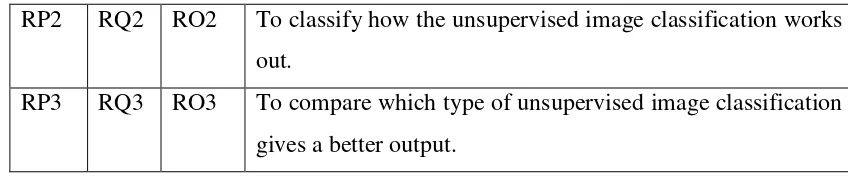
Table 1.3 Research Objectives
RP RQ RO Research Objectives
5
RP2 RQ2 RO2 To classify how the unsupervised image classification works out.
RP3 RQ3 RO3 To compare which type of unsupervised image classification gives a better output.
Based on the research problem and research question that summarised in Table 1.1 and 1.2, a summarised of research question which is Table 1.3 was listed. There are three main objectives that were listed. For RO1, this objective was important to do the comparison between the methods for understand the differences between the methods. As for RO2, this objective was important to know the flow and progress of the method chosen when doing the unsupervised image classification. And as for RO3, this is important to choose the best method which can produce better image for image classification.
1.5 Scopes
The scope of this project was the comparison of unsupervised image classification between Mamdani-type and Sugeno-type classification. In this study, the main area had been identify, and the image used for this study was captured by the satelite. The image was from Malaysia Remote Sensing Agency which using size of 225 x 277 pixels on 256 bits or unsinged integer 8 from QuickBird Satellite Image for June 2010 of Kuala Linggi Mangroves Forest, Alor Gajah Melaka. The software used was Matlab R2009a to do the image compression. Fuzzy logic was used in order to do the comparison between Mamdani-type and Sugeno-type classification.
1.6 Project Significance
6
structures, within multi-spectral data by the algorithms programmed into the software. In order to do unsupervised classification, spectral classes are grouped first, based solely on the numerical information in the data, and are then matched by the analyst to information classes. This study would be beneficial on geography field. By implement this image classification, this could help the geographer to classify out the object captured and apllied on the map for more accurately.
1.7 Expected Output
In this project, the two of method of unsupervised image classification which is Mamdani-type and Sugeno-type classification was being compared to obtain the best result. The Mamdani-type image classification would be getting a better result as compare to Sugeno-type image classification. The Mamdani method should be classified out the better result on the pixels as compared with Sugeno method.
1.8 Report Organization
In report organization, the overall project was divided into six main chapters. In Chapter I, the discussed topics included project background, problem statements, research questions, objectives, scopes, expected output and report organization.
As for Chapter II, the topics covered included literature review, related works, analysis of current problem and justification, and proposed solution. The analysis of the problem was used to do as the project objectives and ways of solution was proposed to solve the problems.
7
For Chapter IV, the topics covered included implementation. The required hardware and software requirement was listed into table and the flowchart for the process of method was drawn. The FIS system for both Mamdani method and Sugeno method was built.
For Chapter V, the topics covered included the testing on the system. The linking between FIS system and image was tested. The classified pixel that belongs to different classes was displayed in different color. The output for both methods was compared. Besides that, the total number of classified pixels was also been counted.
For Chapter VI, the topics covered included conclusion, observation on weakness and strengths, future works and summarization of project objectives was included. The overall summarization for this project was included in this chapter.
1.9 Summary
In conclusion, there are two types of image classification which is supervised and unsupervised classification. Unsupervised image classification was selected to do this project. There are various types of method for unsupervised image classification such as L-Means and ISODATA classification. In this project, the methods used for unsupervised image classification were Mamdani-type and Sugeno-type classification.
In order to do this project, the research problem were listed out such as facing difficulty to understand the different methods of unsupervised image classification, difficult to know the progress of unsupervised image classification and difficulty to know which type of unsupervised image classification give out a better output. The next chapter will cover more details of this project which included literature review and project methodology.
8
differences between the methods of unsupervised image classification, to classify how the unsupervised image classification works out and to compare which type of unsupervised image classification gives a better output.
By implement this image classification, this could help the relevant person or agencies such as geographer to classify out the image and draw out the map easily. In this project, two techniques of fuzzy were used to compare the best classification output of the satellite images.
CHAPTER II
LITERATURE REVIEW
2.1 Introduction
In the previous chapter, the topic included were the project background, problem statement, research questions, objectives, scopes, project significance and expected output. In order to further discover more on the topic chosen, more topics would be discovered. In this chapter, the topic of the related work or previous work, analysis of current problem or justification and proposed solution was included.
The related work or previous works was included in this chapter. This includes the research and comment that had been done before. The facts that was related was included. This was important for understanding the idea or topic that studied. It can be used for reference and can helped as a guidance when doing this project. The literature review can helped to enlarge the area of knowledge field that being studied. Besides that, the advantages of the chosen method was covered also in this chapter. This is to ensure the benefits of applying the knowledge related.
10
By figured out the current problem and doing the justification, the solution to overcome the problem can be done. The current problem was list out by analyze listing out the problem that had been faced. The justification was done by analyze the problem listed and give out solution to overcome that problems.
In order to understand and complete this project, research and problem analyze was important to realize the current stage of understanding on the related topic area. By having a good knowledge on the topic covered, this can helped to obtain the results that expected.
2.2 Related Work
Image classification is an important part of the remote sensing, image analysis and pattern recognition. In some instances, the classification itself may be the object of the analysis. For example, classification of land use from remotely sensed data produces a map like image as the final product of the analysis (Campbell, 2011).
The comparison between the two chosen method is doe based on a given satellite image. Satellites images consist on layers, each layer have special information regarding the satellite specialization directives. For instance, in the Landsat satellite images (specialized in weather forecasting); layer 1 may have water information, layer 2 reports soil information, etc. Each of these layers is in fact a pixel matrix, which can be easily converted into a matrix of real number values. The matrices store specific information corresponding to each color related to the terrain surface at a given location (Susana Arias, 2009).
11
classification is to identify the features occurring in an image in terms of the object (Sunayana G.Domadia, 2011).
Manual classification was done with high precision but development of software technology and expert systems promote us to have more precision with high speed and finally less expense .Using a classified image in GIS results to better interpretation and decision making (S.H. Chavoshi, 2007).
In image classification, there are two main approaches which are supervised and unsupervised. In the supervised approach, the number and numerical characteristics (e.g. mean and variance) of the classes in the image are known in advance (by the analyst) and used in the training step which is followed by the classification step. There are several popular supervised algorithms such as the minimum-distance-to-mean, parallelepiped and the Gaussian maximum likelihood classifiers (Mahamed G, 2005).
An unsupervised classification algorithm is derived by modeling observed data as a mixture of several mutually exclusive classes that are each described by linear combinations of independent, non-Gaussian densities. The algorithm estimates the data density in each class by using parametric nonlinear functions that fit to the non-Gaussian structure of the data (Te-Won Lee, 2002).
The techniques image classification procedure which use for research were distinguished in two main ways as supervised and unsupervised classifications. Additionally, supervised classification has different sub-classification methods which are named as parellelpiped, maximum likelihood, minimum distances and Fisher classifier methods. These methods are named as Hard Classifier. As for unsupervised classification, the method are includes FKM, ISODATA, and CPG. There are also some other classifier such as fuzzy set theory and expert system.
12
of relationships between precise numerical values. (I.Nedeljkovic, 2004)
In this project, the comparison between two methods of unsupervised classification was done based on the ruled-based expert system which is fuzzy logic. Fuzzy logic can improve such classification and decision support systems by using fuzzy sets to define overlapping class definitions. (Hohannes A. Roubos, 2003)
There are many benfits of using fuzzy ruled based system for image satellit classification. Fuzzy based systems are fast and provide good accuracy. In fuzzy, accuracy depends upon the type of membership functions in the output of FIS are arranged (Manish Sharma, 2011).
A pixel in remote sensing images might represent a mixture of class covers, within-class variability, or other complex surface cover patterns. However, this pixel cannot be correctly described by one class. These may be caused by ground characteristics of the classes and the image spatial resolution (Mohd, Suryanna, Sahibuddin, Abdollah, & Selamat, 2012).
The fuzzy inference methods that can be used are Mamdani-type and Sugeno-type. Sugeno-type systems can be used to model any inference system in which the output membership functions are either linear or constant. This fuzzy inference system was introduced in 1985 and also is called Takagi-Sugeno-Kang. Sugeno output membership functions (z, in the following equation) are either linear or constant (Nedeljkovic, 2004).
Two well-known Fuzzy rule-based Inference System are Mamdani fuzzy method and Tagaki-Sugeno (T-S) fuzzy method. In terms of use, the Mamdani FIS is more widely used, mostly because it provides reasonable results with a relatively simple structure, and also due to the intuitive and interpretable nature of the rule base (J. J. Jassbi, 2006).
13
application. Other differences are that Mamdani FIS has output membership functions whereas Sugeno FIS has no output membership functions. Mamdani FIS is less flexible in system design in comparison to Sugeno FIS as latter can be integrated with ANFIS tool to optimize the outputs (Arshdeep, May 2012).
(S. Sumathi, 2010) stated that the advantages of the Mamdani fuzzy inference system are it’s intuitive. It has widespread acceptance, and it’s wellsuited to human cognition. As for Sugeno, it's computationally efficient, it works well with linear techniques (e.g.,PID control), it works well with optimization and adaptive techniques, it has guaranteed continuity of the output surface, and it's well-suited to mathematical analysis.
There are also other advantages of Mamdani-type FIS. For example, it has expressive power; easy formalization and interpretability; reasonable results with relatively simple structure, intuitive and interpretable nature of the rule base; can be used for both MISO and MIMO systems, and the output can either be fuzzy or crisp output (Abdelwahab Hamam, 2008).
The advantages of using Sugeno FIS are the algorithms can be used to automatically optimize the Sugeno FIS. Tools that can calibrate the weights of the Sugeno FIS output is MATLAB’s ANFIS; better processing time since the weighted average replace the time consuming defuzzification process; computational efficiency and accuracy; more robust when in presence of noisy input data, such as sensor data; rules’ consequents can have as many parameters per rule as input values allowing more degrees of freedom and more flexibility in the design; and adequate for functional analysis because of the continuous structure of output function (Abdelwahab Hamam, 2008).