Application of radar polarimetry techniques for retrieval snow and rain characteristics in
remote sensing
M. Darvishi a, *, Gh. R. Ahmadi b
a MSc, Group of GIS/RS, Environment and Energy Department, Science and Research Branch, Islamic Azad
University, Tehran [email protected]
b PhD, Geography Department, Science and Research Branch, Islamic Azad University, Tehran
Key words: Polarimetry, SEW, SAR, Interferometry, Backscattering coefficient
ABSTRACT:
The presence of snow cover has significant impacts on the both global and regional climate and water balance on earth. The accurate estimation of snow cover area can be used for forecasting runoff due to snow melt and output of hydroelectric power. With development of remote sensing techniques at different scopes in earth science, enormous algorithms for retrieval hydrometeor parameters have been developed. Some of these algorithms are used to provide snow cover map such as NLR with AVHRR/MODIS sensor for Norway, Finnish with AVHRR sensor for Finland and NASA with MODIS sensor for global maps. Monitoring snow cover at different parts of spectral electromagnetic is detectable (visible, near and thermal infrared, passive and active microwave). Recently, specific capabilities of active microwave remote sensing such as snow extent map, snow depth, snow water equivalent (SWE), snow state (wet/dry) and discrimination between rain and snow region were given a strong impetus for using this technology in snow monitoring, hydrology, climatology, avalanche research and etc. This paper evaluates the potentials and feasibility of polarimetric ground microwave measurements of snow in active remote sensing field. We will consider the behavior co- and cross-polarized backscattering coefficients of snowpack response with polarimetric scatterometer in Ku and L band at the different incident angles. Then we will show how to retrieve snow cover depth, snow permittivity and density parameters at the local scale with ground-based SAR (GB-SAR). Finally, for the sake of remarkable significant the transition region between rain and snow; the variables role of horizontal reflectivity ( ) and differential reflectivity ( ) in delineation boundary between snow and rain and some others important variables at polarimetric weather radar are presented.
1. Introduction
The radar hydrology provides data that can be used for input to runoff, flood, storm and avalanche prediction models and related natural disasters. In two past decades, noticeable attention has been focused on radar meteorology, hydrology and distributed hydrological modeling. One most important aspects of radar meteorology is the use of polarimetric radar techniques at various frequencies for measuring SWE. Demonstration of satellite SAR data for SWE measurements was first reported by (Shi and Dozier, 2000a, b). Some researches' modeling (Shi, 2004 and 2006) are shown that dual frequencies at combination of X- and Ku-bands are more suitable for monitoring of SWE. On the other hand, one of the most sophisticated methods for retrieving hydrological parameters of snow is SAR differential interferometry (DInSAR) and use of the differential phase. Retrieving SWE by interferometric phase shift in snow due to differences in travelled paths was first
2. Snow polarimetry with ground scatterometer
Over the past two decades, radar polarimetry is a state-of-the-art topic in radar meteorology. The significant characteristics of active microwave sensors at different polarizations and angles and its strong capabilities to extraction of variety data such as stratigraphy, density profile, grain size profile, temperature profile, moisture and SWE of snow are remarkable and promising. The most common wavelengths that used for snow monitoring are L, C, X, Ku bands. L band is long enough to penetrate into the snowpack and depends on snowpack depth maybe reach to the ground. Ku wavelength in order of mm is related to the roughness and dielectric constant of snow. The addition of different wavelengths, using dual co and cross polarization can be involved more physical information about the snowpack. Most measured microwave data pertain to radar remote sensing of snow has been acquired from truck or sensors which placed at some elevations in snow regions. In figure 1 we can see the typical radar truck system.
Figure 1 . L and Ku band radar at Fraser (Saint-Martin et al, 2003)
The procedures of ground base snow polarimetry involve some important steps. One of critical steps is the calibration of instruments for making sure the high accuracy of acquired data. Often a metallic sphere can be used for calibration purposes, since it presents a wide RCS pattern (orientation independent), a relatively small physical size (easy deployment), and a known exact theoretical RCS (Saint-Martin et al, 2003). This step of calibration must be repeated before and after each measurement cycle to have an independent measure of end-to-end for reliability of system performance. Figure 2 show the typical example of metallic sphere and calibration process.
Figure 2 . A typical metallic sphere for calibration purpose (Saint-Martin et al, 2003)
For obtaining the backscattering coefficients of snowpack, first we need to extract the scattering matrix from acquired data. The elements of scattering matrix involve both magnitudes and phases of the reflected signals relative to that of the incident signal for all polarization combinations
With take into account of far and near field considerations, therefore (1) is usually written as though the scattering properties are observed back at the radar
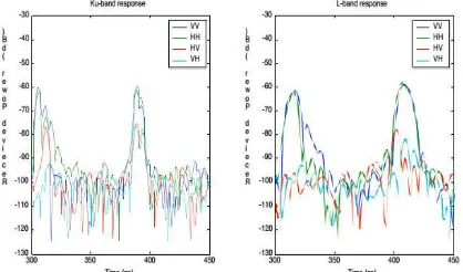
The exponential term accounts for the phase difference induced in transmission which can be ignored since it will affect all components equally (J. A. Richards, 2009). After calculating , we will obtain the backscattering coefficients in dB. Figures 3 and 4 show the results of radar polarimetry in Ku and L band.
Figure 4 . Backscattering coefficients at Ku and L band (Saint-Martin et al, 2003)
3. Snow parameters retrieval with intreferometric SAR (DInSAR)
There are many methods for cover and depth snow parameters retrieval both in passive and active remote sensing. Retrieval of those parameters in active remote sensing can be done by space born and air born radar imaging. The use of these methods has some limitations such as lack of appropriate resolutions and low acquisition rate, as well as high cost. In intreferometric technique especially SAR differential interferometry (DInSAR), we need consecutive images much higher acquisition rate than the space or air born sensors provided for us. GB-SAR has a high capability for generating the higher acquisition rate in very large time-series of repeat-pass radar images. Having this sort of data can improve the performance of snow parameters retrieval especially in local scale. The acquired snow parameters retrieval often uses in models for estimation snow water equivalent (SWE) as inputs. SWE is a most significant variable for water sources planning and Hydraulic power management. The first step for depth retrieval is phase conversion into height. Backscattering of radar is strongly affected by complex permittivity of snow which is intensely dependent on its liquid water content. The penetration depth of microwaves at the wavelength in free space can be estimated from the real and imaginary parts of the complex permittivity of snow according to (Mätzler, 1995):
The imaginary part of the permittivity, ε'', of dry snow at C- and L-band is of the order of 0.001 to 0.0001, whereas the real part, ε', depends only on the snow density (Mätzler, 1995), where is specified in g/c .
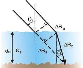
The phase comparison of a pair of complex coherent radar images of the same scene that acquired in different time and Repeat-pass can generate a differential interferometry. If we define as the depth of whole snow in a particular time and as the depth of whole snow in a later time than the previous one and considering the two different paths of pulses emitted (figure 5), will equal to
Figure 5 . Propagation path of microwaves (Nagler, 2003)
Base on the Snell’s law, the interferometric phase shift in dry snow related to can be written as (Guneriussen et al, 2001):
Finally, the differential snow depth after substituting some variables ( and ) with a constant [ ] is obtained
Sometime constant is added to the last equation as an offset for calibration purposes.
3. Dual Polarization Radars
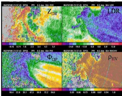
thermodynamic phase. Differential reflectivity ( ) is calculated by the reflectivity in horizontal to the vertical polarizations of the hydrometeors in a sampling volume from linearly polarized radars.
Is a meteorological echo and generally its range is between -2 dB and 6 dB. For raindrops is usually (0-4 dB). At the end edges of convective showers can be 4 dB. Snow, depending on whether it is wet or dry and the amount of riming and aggregation can range from 0 to 3 dB. For refresh ice crystals can be > 5 dB. For ice segments considerably is various, but typical orders are often between 0.1 and 0.5 dB. Graupel and hail have a close to 0 dB (for more details see figure 6).
Figure 6 . The relation between and axes ratio
LDR is another variable that can be used for better discrimination in mixture regions of hydrometeors. LDR can detect rolling, swinging, spinning angles, phase and disordered shaped hydrometeors. For large rain drops (LDR> -25 dB), hail and rain mixtures (-20 -10 dB) and wet snow (-13 -18 dB).
is the magnitude of the complex correlation coefficient between copolar voltages. Decorrelation has been known to occur in large hail, wet or spongy hail, and mixtures of rain and hail (Balakrishnan et al, 1990). It can be used for discrimination in mixture regions of hydrometeors, particularly between rain and snow.
Defined as a Phase difference in H and V caused by backscattering. The range of this variable is between 0 and 1. The values above 0.96 mean the hydrometeors that have size, shape, orientation or phase and values below 0.96 show the mixture of hydrometeor. The echoes of large hail or non-rain yield the values below 0.8. Called Differential Phase, this variable is measured by the
difference phase shift between horizontal and vertical polarized pulses.
The same as , if range-integrated horizontal phase shift be larger than range-integrated vertical phase shift then
will be positive. For spherical particles and hail are immune to attenuation since those particular hydrometeor roughly generate the same phase shift in the vertical and horizontal directions. Particles with oblate shapes of hydrometeor such as large drops rain and ice crystals have horizontal phase shift larger than that lead to increase . Figure 7 indicates four variables.
Figure 7 . A Typical indication of mentioned variables (PPI-screen)
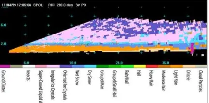
Specific Differential Phase (KDP) is defined as the range derivative of , and therefore is not directly measured by the radar. Possible values range from -2 to7 in units of degrees per kilometer.
Figure 8 . Discrimination of hydrometeors types by radar
4. Conclusion
In section 1, the researcher of Michigan University after using of scatterometer in Ku and L bands at different angles reached two main conclusions. First, the dynamic range over which the backscattering coefficient varies is much larger when the snowpack goes through freeze-thaw condition and when snow water content reaches 3%-5%. At Ku-band, once the snow depth is higher than 1 meter, the snow depth variations do not influence anymore. Second, with the observed snow parameters variations, the two co-polarized backscattering coefficients are shown to be highly correlated, at both frequency bands, and at any given incidence angle (Saint-Martin et al, 2003). In section 2, we theoretically showed the capabilities and advantages of GB-SAR technique rather than its peers, i.e. air and space borne SAR in snow parameters retrieval. Finally, in section 3 pointed to the most significant radar common variables in meteorological applications that have a vital role in storm and weather forecast. Now days the importance and role of remote sensing polarimetirc radars in geoscience scope is prominent and undeniable.
References
J. Shi and J. Dozier, 2000a. Estimation of snow water equivalence using SIR-C/X-SAR. I. Inferring snow density and subsurface
properties. IEEE Trans. Geosci. Remote Sens., vol. 38, no. 6,pp. 2465–2474
J. Shi and J. Dozier, 2000b. Estimation of snow water equivalence usingSIR-C/X-SAR. II. Inferring snow depth and particle size. IEEE Trans. Geosci. Remote Sens., vol. 38, no. 6, pp. 475–2488
J. Shi, 2004. Estimation of snow water equivalence with two Ku-band dualpolarization radar. inProc. IGARSS, pp. 1649–1652.
J. Shi, 2006. Snow water equivalence retrieval using X and Ku band dual polarization radar. inProc. IGARSS, Denver, CO,pp.2183–2185.
Guneriussen T., Høgda K.A., Johnson H. and Lauknes I., 2001. InSAR for estimating changes in snow water equivalent of dry snow. IEEE Trans. Geosc.Rem. Sens., Vol. 39(10), 2101- 2108
Galahad., 2005-2008. Advanced Remote Monitoring TechniquesorGlaciers, Avalanches and Landslides Hazard Mitigation. Project N. 018409, European Commission - 6thFrameworkProgramme http://www.galahad.it
K. Morrison, H. Rott, T. Nagler, H.Rebhan and P. Wursteisen, 2007 . The SARALPS-2007 measurement campaign on X and Ku-BandBackscatter of snow. Proc. IEEE Geosc.and Remote Sens. Symposium Doviak and Zrnić., 1993. Doppler Radar and Weather Observations. Academic Press.
G.C Saint-Martin, K. Sarabandi., 2003. Polarimetric Ground Microwave Measurements of Snow Covered Terrain at L-band and Ku-band in Support of the NASA Cold Land Processes Mission (EX-7). Radiation Laboratory of University ofMichigan
J. A. Richards, 2009. Remote Sensing With Imaging Radar. Springer, pp. 101-102.
C. Mätzler., 1995. Microwave permittivity of dry snow. IEEE Transactions on Geoscience and Remote Sensing, vol.34 (2), pp.573-581
T.Nagler, R.Scheiber., 2003. snow mass retrieval by means of SAR interferometry. Workshops, ESA, pp.2.