SURVEY GUIDELINES AND ITS READING CRITERIA FOR MONITORING AND
TRANSMITTING CULTURAL HERITAGE VALUES
A. De Masi
ABC, Dept. of Architecture, Built Environment and Construction Engineering, Milan Polytechnic, II School of Architecture, Via Durando 10, 20158 Milan – [email protected] - [email protected]
Commission VI, WG VI/4
KEY WORDS: Analysis and Interpretation of Material Systems, Survey Guidelines, Reading Criteria, Drawing as a Laearning System of Architectural Heritage, Relief as a Knowledge Framework, 2D/3D digitization of Cultural Heritage
ABSTRACT:
The paper describes reading criteria for an analysis and interpretation of material systems in relation to a built space, survey guidelines and its reading criteria for Cultural Heritage (CH) values’monitoring and transmission. In addition, integrated systems of digital technologies and 2D/3D digitization of CH are introduced for an effective and accurate reading of Venice and Milan’s monuments. Specifically, the guidelines for an architectural survey allow to organize and document historic monuments information, and to identify the significant cultural/physical elements of our past in order for them to be preserved and protected for future generations. In addition, in this paper the studied projects introduce a combination of virtual technologies and historical reality with experimenting innovative solutions for CH. From the methodological point of view, this study has made use of the identification of levels of study (LS) differentiated, each of which is capable of identifying categories.
1. INTRODUCTION 1.1 Objectives
The paper describes reading criteria for an analysis and interpretation of material systems in relation to a built space, survey guidelines and its reading criteria for CH values’monitoring and transmission. In addition, integrated systems of digital technologies and 2D/3D digitization of CH are introduced for an effective and accurate reading of Venice and Milan’s monuments. In this paper the studied projects introduce a combination of virtual technologies and historical reality with experimenting innovative solutions for CH. The new digital technologies allow to detect info-graphics representations that can be easily adapted to the different needs of scholars from the field. The integrated digital architectural survey not only represents a critical analysis of the city’s historical architecture but is also a “container” for the multi-scale cataloging of the architecture that returns a three-dimensional numerical model.Specifically, the guidelines for an architectural survey allow to organize and document historic monuments information, and to identify the significant cultural/physical elements of our past in order for them to be preserved and protected for future generations. In the second part of the paper, I will analyze the interpretation of material systems and intangible assets, the importance of drawing as a learning system of architectural Heritage, the route to knowledge and the steps to study and monitoring CH's state of preservation. In the third part, I will report reading criteria for architectural surveys and CH's digitization.
2. MAIN BODY 2.1 Research Methodology
It was identified a methodology for reading that can return a survey aimed at evaluating changes induced by simultaneity through the decomposition of multi-scale representation of the parties examined by Digital Representation Platform (DRP) (De Masi, 2014). I identified relief guidelines aimed at the realization of architectural sites multi-scale models. This was
methods of 2D/3D digitization, and Open Source for CH preservation will be reported.
2.2 Analysis and Interpretation of Material Systems and Intangible Assets
An historic context might encompass the development of an area taking into account its history, architecture, archeology and culture. It also might identify the significant patterns that individual monuments represent within that context. The guidelines on criteria and conditions for evaluation of CH Assets in relation to a built space were as follows: 1- Historic and aesthetic significance. It is related to its style, technical excellence, beauty, quality of design and execution. 2- Scientific or research significance. 3- Social and spiritual significance. The analysis also was based on the following criteria for complex representation: 1- Intrinsic significance (Authenticity, Extent/Completeness, Integrity, Continuity of use/demonstration, Corpus of evidence/study). 2- Contextual significance (Rarity, Representativeness /Uniqueness, Diversity, Physical context, Threat/fragility). 3- Associative significance (Historic interest and association, Aesthetic attributes).
2.2.1 Drawing as a Laearning System of Architectural Heritage
The introduction of digital systems for analysis and CH’s interpretation included: 1- a drawing as a complex and comprehensive system capable of combining metric and dimensional qualities with sensitive-perceptive qualities. 2- a drawing as a complex multidimensional system of an architectural reality representation. In addition, the interrelation of the concepts of dimensional representation to other aspects related to the culture of antiquity and conservation. Two spheres of action can be defined: 1- collecting perceptual and visual, metric or dimensional data about the place of study for the representation of the empirical, physical and geometric space. The objective is to explore the relations between the elements of a given space-object. 2- the intentional evaluation of the data collected to establish criteria for segregation, distinction and order in the representation of the architecture. This occurs when the concept of the physical scale appears as a metric relation between real and represented dimensions that depends on the amount and quality of the information to be supplied. Therefore, a graphic analysis for an effective CH’s evaluations(Docci, 2009) will be carried out with study steps as it follows: 1- A functional analysis to point out space organization, orizontal and vertical paths, surfaces for different functions, natural lightning and orientation, technological structures. 2- Analysis of the pillar and continued supporting structure, and the archivaulted system. 3- Analysis of the architectural elements or a formal analysis provided with a geometrical and proportional study; elements of side closures: facades; elements connected to the ground; roofing elements: roofs and terraces; joint elelments in between side closures: corner solutions; links between the outside and the inside; atrium access; vertical connection elements: stairs and ramps. 4- Spatial analysis. 5- Analysis of the relationship between the construction and its context, a necessary planimetry report on paths, relationships among the different architectonic emergencies, a visual perspectical analisys, relationships with green spaces, etc.
2.2.2 Drawing as a Graphic Dimensional Reconstruction of Buildings and Analysis of Architecture’s Intrinsic Qualities The drawing used was not just a graphic dimensional reconstruction of buildings, but also an analysis of
reflected in the development of twentieth century courses of study that basically divided architectural drawing, and consequently the drawing of architectural heritage, into two distinct spheres: “technical” drawing that consisted basically in defining the dimensional qualities of the object by using measurable systems of representation (basically, projections) and “artistic” drawing focused on expressing architectural qualities more closely tied to perception than description (Celis et al., 2011).
Figure 1- Piranesi, interior facade Ottavia colonnade. Facade sections
Figure 2 – Vnvitelli, L. From left above, Scene for Tito Manlio (inventory 1687), Longitudinal section of the Missions church in Naples, Longitudinal Section of the church of SS. Marcellino
and Festo in Naples, Italy
2.3 Relief as a Knowledge Framework: Multidimension and Multidiscipline
Architectural survey is a process for identifying and gathering information about historic architectural buildings. The architectural survey is an operation to learn about the work as a whole, grasp its dimensional, constructive, formal and cultural values (Docci & Maestri, 2009). It is to put in place a complex procedure that determines the in-depth knowledge of the work to detect, through a critical reading of the drawings made.
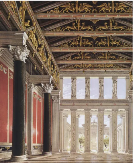
Figure 3 – Schinkel, K.F. Royal Palace in the Acropolis. Inside the vast reception room
Figure 4 – Schinkel, K.F. Cross sections of the Throne Room, 1835
studied are reported (vaults, roofing, flooring, fixtures, etc.). 4 – “Detection of constructive and decorative details” of architectural orders, technical and construction details - 1:20 and 1:1 scale. 5- “Survey of the walls” with reference to the building modules, materials and their finishes, plasters and coatings. 6- Relief (hue, texture of the material and the kind of color). 6- Processed themes: geometry and proportion of buildings. Among the planimetric detection methods, the following were used: 1- trilateration. 2- detection for polar coordinates or radiation. 3- detection for polygonal. In particular, I used the direct method (employed in most architectural reliefs and indispensable for the realization of the plants and of the edifice sections), the instrumental method (complementary to the direct one and photogrammetric), and the photogrammetric method (used to get a considerably precise relief). Freehand drawings executed with the direct detection method and the technical design are presented in Figure 6. The work done for the Royal Palace in Milan follows the above structure. In particular: 1- Design and project detection of the ground floor plan (PT). 2- Measures survey for plant PT. 3- Design and project tracking plants of the upper floors. 4- measures survey of the upper floor plants. 5- Measures survey of the building section. 6- Project survey of prospects. 7- Measures survey of the building elevation. 8- Survey project of architectural details. 9- Graphical representation of plants, sections, elevations and architectural details. (Figures 5, 6, 7, 8). As for the surrounding environment and the shape of the object, the survey project is oriented towards a prevalent use of 3D scanning. The survey was conducted by integrating 3D Leica ScanStation 2 scanner functions and Leica TCR 1201 R300 total station. It was also made an extensive photographic campaign. At the same time an open polygonal was built from which 40 support points were measured. Such points were materialized in place by as many aims. These latter have been subdivided into two types: a general with a sample spacing of 5x5 mm and a detailed one of 2x2 mm.The double measuring of the target is the heart of the discovery protocol with a rotary translation of the 3D cloud on the topographic points. This occurred with the collimation of homologous points represented by the aims. The survey represents the body of a theory-operation, through which we come to know the material elements of a CH (Docci & Maestri, 2009). It should emphasize the multidimensional and multidisciplinary nature of this process which effectively provides a system for collecting, interpreting and storing quantitative and qualitative knowledge. With regard to the multidimensionality, it is worth recalling some basic concepts related to the so-called culture of space control. The geometric model, subject to a representation process, turns into a two-dimensional graphic model, that is a guaranteeing tool of the graphic model’s control mechanisms. The geometrical model reconstructed in a virtual form becomes a 3D digital model. Based to this approach, the multidimensional reality is reduced to its geometric essence. In the survey’s development, one can notice a dichotomy between the phase of data acquisition, increasingly dependent on the use of new “objective” 3D scanning technologies, and the ways in which the analysis is carried out in place of the studied object. The traditional approach, in this case, would consider the detection phase as complimentary of a preliminary study phase able to set the measurement possibilities. Detection and analysis would basically merge into one act. Most recent techniques have actually clearly separated the two moments. Photogrammetry is cited, as it checks out the project’s feasibility through necessary topographic measures that will allow a stereophotogrammetric model generation. Here, the phase of data acquisition appears clearly distinct from the other. This approach is also suitable to the 3D scanning technology.
All these considerations outlines how the relief phase must be part of a broader knowledge framework where it is well recognized the border line between data acquisition and selection and elaboration criteria of the data base.
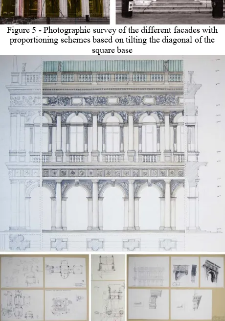
Figure 5 - Photographic survey of the different facades with proportioning schemes based on tilting the diagonal of the
square base
Figure 6 - Collection of perceptual, visual, metric and dimensional data of the Biblioteca Marciana in Venice, Italy. Course of Architectural Drawing, IUAV University of Venice
(De Masi, A.)
2.4 Formal, Geometric and Proportional Study
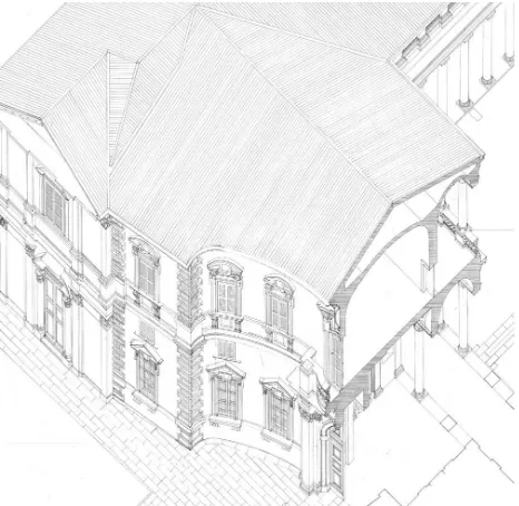
Figure 7 – Architectural Survey of the Senate Palace in Milan, Italy. Course of Drawing, Milan Polytechnic (De Masi, A.)
Figure 8 – Isometric Cross section of the Senate Palace in Milan, Italy. Course of Drawing, Milan Polytechnic
(De Masi, A.)
construction technique. The next phase focused on the search for a possible unit as key regulator of the entire building. Typically such analysis is started exploiting the presence of architectural elements (such as the order) whose form reveals the proportional scheme of the entire construction; alternatively, one can refer to the hypothetical presence of a certain unit of ancient measurement (foot, palm, cubitus, etc.) derived from sources of different nature. The analysis conducted on the metric-proportional architectural form derived from the order showed a geometric matrix base. (Figures 9, 10)
2.5 The Route to Knowledge and the Study Steps to Analizing and Monitoring CH’s State of Preservation knowledge of a CH’s state can be reached through various in-depths analyses, depending on the accuracy of survey
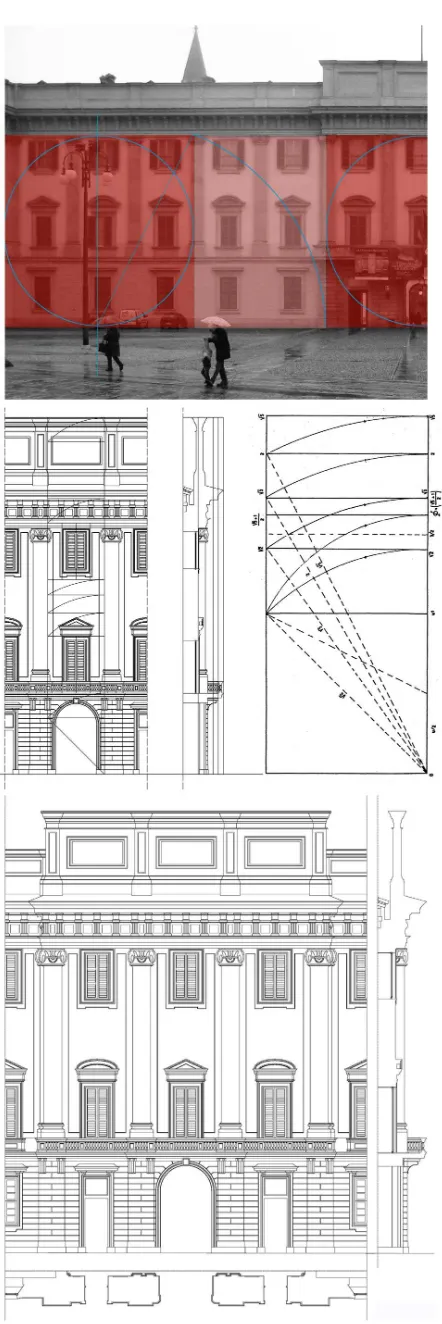
Figure 9 - Royal Palace in Milan, Italy. Dimensional and architectural survey. Course of Drawing, Milan Polytechnic
(De Masi, A.)
Figure 10 - Royal Palace in Milan, Italy. Architectural survey and proportioning schemes based on tilting the diagonal of the
square base and that of successive rectangles. Course of Drawing, Milan Polytechnic (De Masi, A.)
each successive floor in a logical order. It is usually best to begin with the first floor and move up to the attic. 5- Describe the interior of any wings or additions with particular attention should be paid to the spatial and functional relationship of the wing to the house. After the house has been described, move out into the yard. Describe any outbuildings or farm buildings that are considered significant, as well as historic landscape features (GAHI). Other issues include: a-Deterioration of the property’s historic integrity. b- Date of restoration. c- the historical basis for the work done. d- the amount of remaining historic material and replacement material. e- The effect of the work on the property’s historic integrity. f- The historic appearance and current condition of natural features (GAHI). g- landscape features and vegetation that characterized the property (gardens, walls, paths, roadways, grading, fountains, orchards, open spaces, and bodies of water. h- The historic appearance and current condition of both man-made features and natural features throughout the area. g- Land uses, features, and vegetation that characterized the roadway (GAHI). 6) Constructive aspect with sub-categories related to the survey of constructive and decorative details (scales 1:20 and 1:5); walls relief with respect to materials and finishes, plasters and coatings. 7) Surfaces analysis through a chromatic survey with regard to the type of color, the color shade, and the texture of the material. In this case, it is essential to identify the percentage of the existing colors, their classification code, the areas of degradation, and the amount of degraded surface. 8) Type of building, intended use, pre-existing and current. 9) Current technological aspects. 10) Classification of identity and contemporary signs from the different elements contained in the sub-categories. 11) Registry identification for a three-parametric evaluation: denomination, toponymy and land registry data. 12) Sensitivity factors in order to evaluate: a) a relationship between manufacts and territorial context; b) geographic, geomorphological and antropic characteristics; c) accessibility. 13) Morphology elements in order to identify structural elements, inspectionability, building technique, materials and elements of historic and/or artistic value. 14) Preservation State. LS goal is to provide tools for a proper reading of the building’s constructive system, for interpretating the damage causes, and for identifying anomalies and structural instability in order to choose the most suitable form of intervention. About the architectural and historic districts, the following aspects were taken into consideration: 1- Visual frameworks in the urban space (Lynch, 1960): a) Visual plans. b) visual cones. c) Landmarks. d) Main / visual emergencies. e) Visual circumscribed areas. f) Margins / visual barriers. g) Elements of visual disturbance. h) Photographic sequence of the building facades including the building studied and the corresponding profiles. i) Chromaticity of volumes and predominant chromaticity in the stretch of road analyzed. 2- Natural and man-made elements comprising the district, with topographical features and structures, buildings, sites, objects, and other kinds of development. 3- Architectural styles and periods represented and predominant characteristics (proportions, materials, decoration, workmanship, quality of design, etc.) (GAHI). 4- General relationship of buildings to each other and to the environment (facade lines, street plans, squares, open spaces, density of development, landscaping, principal vegetation, and important natural features). 5- Appearance of the district during the time with achieved significance and any substantial modifications. 6- Character of the district (residential, commercial, industrial, cultural) and types of buildings and structures. 7- Condition and identity of the buildings, (including alterations, additions, restoration). 8- Qualities of the district and open space such as parks, agricultural areas, vacant lots or
ruins that is where relevant activities took place in history or prehistory.
2.6 Critical Reading of Architectural Surveys and Relief Materials
The buildings architectural significance is intended as a complete description of stereometric factors, including any cracking phenomena and deformations. Therefore, it involves identifying the plano-elevation aspects of the building blocks. The relief must refer to the geometry of the body rather than to the construction elements. Shall be recognized and represented the possible crack pattern, so as to enable the identification of the causes and possible evolution of the structural problems of the organism. The best scale of representation is 1:50 for a representation of all the qualifying elements. A survey of construction materials is to identify the quality and the conservation state of the components. Such recognition includes collecting pieces of often hidden information through non-destructive investigation techniques, consisting of direct or indirect weakly inspections. A critical reading of the architectural survey and material, along with a study on the results of the aggregate’s diachronic evolution, highlights the seismic vulnerability of the building or aggregates. A careful reading of the relieves can actually identify the fundamental spatial connections among the different constituent elements of the aggregate with particular attention to juxtaposition, overlapping and recast building mechanisms. Specifically, this phase will focus on: 1 - The typological transformation system. 2- The formation of aggregated interior spaces. 3- Spatial relationships of the individual cell walls; regularity and modularity at the different floors. 4- The walls alignment, rotations and intersections of the walls axes. 5- Shapes and positions of the openings in the walls.
2.7 Graphic Processing
they constitute the reference vector on which also the 2D images, obtained by a parallel projection, can be drawn to scale, and then superimposed to the profile itself. However, these representations, although metrically reliable and "qualitative" rich in information, cannot exhaust the needs of the various parties involved in studies, researches or actions on the object.
3. Cultural Heritage’s Digitization
Recently have been introduced semi-automated image-based methods such as Structure-From-Motion (SFM) and Dense Multi-View 3D Reconstruction (DMVR) methods. The SFM-DMVR (algorithms from unordered image collections) attempts to reconstruct depth from a number of unordered images that depict a static scene or an object from arbitrary viewpoints. The cases study are a attempt for the 3D digitization and representation of two CH in Milan, Italy. The 3D digitization of the monuments could be performed using photogrammetric survey with multi-image 3D reconstruction. The position of the two monuments allow the selection of viewpoints for photoshooting around the model. I used Agisoft PhotoScan as software solution for the production of digital 3D replicas of monuments. Infact, the process of capturing require temporary scaffolding for the image-based methodologies. I need to create a complete exterior 3DM of a monument using terrestrial photography. Moreover, I compare the 3D mesh produced by the SFM-DMVR software against the data I captured using terrestrial 3D laser scanning and total station surveying. For the terrestrial photo shooting session a DSLR Nikon D40 (18-55 mm lens) has been used with distance of the camera from the monument’s surface was estimated at 5 meters. The range scans covered both high and low curvature areas that were enough for validating the quality of the data produced by SFM-DMVR software (Koutsoudis et al.). A total of 400 photographs has been used for the 3D model of the monument 300 and a total of 24 points were measured using a Topcon GPT-3005N total station. The SFM-DMVR software (Version 0.8.5) has been used for this case study. (Figures 11, 12)
Figure 11 – Central Financial offices “La Centrale” (1954-55) in Milan, Italy (architects P. Lingeri, P. G. Bosisio, U. Busca, G. Casalis and C. Maltini). Image position around the building and
reconstructed CH by Smooth Shaded Triangular Mesh and Vertex Painted Medium Quality Triangular Mesh. Course of
Architectural Drawing, Milan Polytechnic (De Masi, A.)
4. Result and Conclusion
This paper describes reading criteria for the analysis and interpretation of material systems, conditions for evaluation of CH assets, integrated systems of digital technologies and 2D/3D
Figure 12 – Central Financial offices “La Centrale” (1954-55) in Milan, Italy (architects P. Lingeri, P. G. Bosisio, U. Busca, G.
Casalis and C. Maltini). Architectural Model. Course of Architectural Drawing, Milan Polytechnic (De Masi, A.)
digitization of CH and the procedures followed by DRP through graphic analysis and integrated digital survey. The guidelines for an architectural survey allow to organize and document historic monuments information, and to identify the significant cultural/physical elements of our past in order for them to be preserved and protected for future generations. In addition, in this paper the studied projects introduce a combination of virtual technologies and historical reality with experimenting innovative solutions for CH.
REFERENCES
Bianchini, C. 2001. Modelli Discreti e Modelli Continui nel Rilievo e Rappresentazione Informatizzata dell’architettura. In: Disegnare. Idee immagini, 22, pp. 51-60. Italy.
Brizard, T. Derde and W. Silberman, N. 2007. Basic Guidelines for Cultural Heritage.
Celis, F., Echeverria, E. and Da Casa, F. 2011. Drawing as a Learning System of Architectural Heritage. In: XXIII CIPA Symposium - Prague, Czech Republic - 12/16 September 2011 - Proceedings
Celis, F., El dibujo de la Antigüedad, Academia Española de
Historia, Arqueología y Bellas Artes, Roma, 1996, 24-27. Celis, F., Goycoolea, R., Alcalá, la experiencia gráfica en una nueva escuela, Revista EGA nº6, Valencia, 2001, 114-116 Echeverría, E., “Colegio Convento de nuestra Señora del Carmen de los Carmelitas Calzados”, Universidad de Alcalá: de las armas a las letras, Alcalá, 2010, 179-185.Coors, V. 2001. Feature-Preserving Simplification in Web-based 3D-GIS. In:
Proc. of Int. Symp. On Smart Graphics.
De Masi, A. 2014. Advanced 3d Recording Techniques and Reality–based Modelling of Multi-scale for Digital Preservation of Cultural Heritage and Sites. In: Proc. of 3rd International Conference Heritage 2014. Barcelos, Portugal.
Docci, M. & Maestri, D. 2009. Manuale di rilevamento architettonico e urbano: Bari: Laterza.
Foley, J. Van Dam, A. Feiner, S. and Hughes, J. 1995. Computer Graphics: Principles and Practice. In C. Addison-Wesley Professional, 2nd Ed.
Guidelines on Cultural Heritage. 2012, JP - Technical report EU/CoE Support to the Promotion of Cultural Diversity. Kluwer Academic Publishers, 1997, Data Mining and Knowledge Discovery) °c 199, Vol. 1, pp. 29-53. ISBN:1-58113-737-0.
Koutsoudis, A. Arnaoutoglou, F. and Remondino, F. 3D-ICONS: 3D Digitisation of Icons of European Architectural and Archaeological Heritage [Online]. Available: 3dicons-project.eu/Artices within reviews.
Lynch, K. 1960. The Image of the City, Cambridge Massachussettes MIT Press.
Koutsoudis, A. Stavroglou, K. Pavlidis, and G. Chamzas, C. 2011. 3DSSE – A 3D Scene Search Engine – Exploring 3D Scenes Using Keywords. In Journal of Cultural Heritage. ICOMOS Charter for Interpretation and Presentation of Cultural Heritage Sites (www.enamecharter.org) Professionals in the Use of Information Technologies.
Letellier, R. 2007. Recording, Documentation, and Information Management for the Conservation of Heritage Places, The Getty Conservation Institute, USA. ISBN: 978-0- 89236-925-6 (pbk.). Marinelli, C. 1991. L’esercizio del Disegno. I Vanvitelli, Catalogo Generale del fondo dei disegni della Reggia di Caserta, Leonardo De Luca Editori.
Pavlidis, G. Koutsoudis, A. Arnaoutoglou, F. Tsioukas and V. Chamzas C. 2007. Methods for 3D digitization of Cultural Heritage, JCH, Volume 8, Issue 1, pp. 93-98.