SUSTAINABLE FISHERIES
MANAGEMENT PROJECT (SFMP)
Synthesis of Scientific and Local
Knowledge on Sardinella Species in
Ghana
This publication is available electronically in the following locations: The Coastal Resources Center
http://www.crc.uri.edu/projects_page/ghanasfmp/
Ghanalinks.org
https://ghanalinks.org/elibrary search term: SFMP
USAID Development Clearing House
https://dec.usaid.gov/dec/content/search.aspx search term: Ghana SFMP
For more information on the Ghana Sustainable Fisheries Management Project, contact:
USAID/Ghana Sustainable Fisheries Management Project Coastal Resources Center
Graduate School of Oceanography University of Rhode Island
220 South Ferry Rd.
Narragansett, RI 02882 USA
Tel: 401-874-6224 Fax: 401-874-6920 Email: [email protected]
Citation: Castro, K., Skrobe, L. Asare, C. and Kankam, S. (2017). Synthesis of
Scientific and Local Knowledge on Sardinella species in Ghana. The USAID/Ghana Sustainable Fisheries Management Project (SFMP). Narragansett, RI: Coastal Resources Center, Graduate School of Oceanography &URI Fisheries Center, University of Rhode Island and Hen Mpoano, Windy Ridge Extension, Takoradi, Ghana. GH2014_ACT090_HM_URI 47 pp.
Authority/Disclaimer:
Prepared for USAID/Ghana under Cooperative Agreement (AID-641-A-15-00001), awarded on October 22, 2014 to the University of Rhode Island, and entitled the USAID/Ghana Sustainable Fisheries Management Project (SFMP).
This document is made possible by the support of the American People through the United States Agency for International Development (USAID). The views expressed and opinions contained in this report are those of the SFMP team and are not intended as statements of policy of either USAID or the cooperating organizations. As such, the contents of this report are the sole responsibility of the SFMP team and do not necessarily reflect the views of USAID or the United States Government.
Detailed Partner Contact Information:
USAID/Ghana Sustainable Fisheries Management Project (SFMP) 10 Obodai St., Mempeasem, East Legon, Accra, Ghana
Telephone: +233 0302 542497 Fax: +233 0302 542498
Maurice Knight Chief of Party [email protected]
Kofi Agbogah Senior Fisheries Advisor [email protected] Nii Odenkey Abbey Communications Officer [email protected]
Brian Crawford Project Manager [email protected]
Bakari Nyari Monitoring and Evaluation Specialist [email protected] Justice Odoi USAID Administrative Officer Representative [email protected]
Kofi.Agbogah
SNV Netherlands Development Organisation #161, 10 Maseru Road,
E. Legon, Accra, Ghana 233 30 701 2440 Donkris Mevuta Kyei Yamoah
[email protected] Friends of the Nation Parks and Gardens Adiembra-Sekondi, Ghana 233 312 046 180
Peter Owusu Donkor Spatial Solutions
[email protected] #3 Third Nautical Close,
Nungua, Accra, Ghana
Darkuman Junction, Kaneshie Odokor Highway
Accra, Ghana 233 302 315894 Gifty Asmah
[email protected] Daasgift Quality Foundation
Headmaster residence, Sekondi College Sekondi, Western Region, Ghana 233 243 326 178
For additional information on partner activities:
CRC/URI: http://www.crc.uri.edu
CEWEFIA: http://cewefia.weebly.com/
DAA: http://womenthrive.org/development-action-association-daa
Daasgift:
https://www.facebook.com/pages/Daasgift-Quality-Foundation-FNGO/135372649846101 Friends of the Nation: http://www.fonghana.org
Hen Mpoano: http://www.henmpoano.org
SNV: http://www.snvworld.org/en/countries/ghana
SSG Advisors: http://ssg-advisors.com/
ACRONYMS
DA District Assembly
EUC Equatorial Under Current
FAO Food and Agriculture Organisation FGD Focus Group Discussion
GC Guinea Current
GUC Guinea Under Curent
GCLME Guinea Current Large Marine Ecosystem GSS Ghana Statistical Service
GUC Guinea Under Current
ITCZ Inter-Tropical Conversion Zone LEK Local Ecological Knowledge LME Large Marine Ecosystem
MFRD Marine Fisheries Research Division
NOAA National Oceanic and Atmospheric Administration ROMS Regional Ocean Modeling System
SEK Scientific Ecological Knowledge SST Sea Surface Temperature
WRI Water Research Institute
TABLE OF CONTENTS
ACRONYMS ... iii
TABLE OF CONTENTS ... iv
LIST OF FIGURES ... v
LIST OF TABLES ... vi
ACKNOWLEDGEMENTS ... vii
INTRODUCTION ... 1
Types of Knowledge ... 1
Importance of Sardinella to Ghana ... 4
THE ENVIRONMENT ... 6
Currents ... 6
Wind and Rainfall ... 8
Bottom Topography ... 13
THE FISH AND THE FISHERY ... 14
Two Main Species... 14
Local Knowledge: When do you find sardinella in abundance? ... 15
Fishing Gear and Methods ... 17
Management ... 23
The Round Sardinella: Sardinella aurita ... 26
Growth and Maturity... 28
Spawning... 29
The Flat Sardinella: Sardinella maderensis ... 31
Growth and Maturity... 32
Spawning... 32
SOME IMPORTANT POINTS ... 33
STATUS OF KNOWLEDGE ... 34
RESEARCH GAPS ... 36
LIST OF FIGURES
Figure 1. The information about Sardinella species in the Gulf of Guinea is spread out among
many journals, reports and languages. Some are not readily available. ... 1
Figure 2. Fishermen from Elmina participating in collaborative research project sharing knowledge. ... 2
Figure 3. Fisherman from Tema participating in the individual interview (Photo credit: Hen Mpoano). ... 3
Figure 4. Sardinella was listed as the primary fish captured by 53 of the 84 respondents. ... 4
Figure 5. One of the principal ports for landing Sardinella- the Port of Elmina (M. Boucher) . 5 Figure 6. Map of Ghana. ... 6
Figure 7. Guinea Current Large Marine Ecosystem ... 7
Figure 8. Surface circulation in the eastern tropical Atlantic. NECC: North Equatorial Counter Current; GC: Guinea Current; SEC: South Equatorial Current. Hatched belt along the coast: Seasonal upwelling and Sardinella aurita fishery area ... 7
Figure 9 Subsurface circulation in the eastern tropical Atlantic. EUC: Equatorial Under Current, GUC: Guinea Under Current; BUC: Benguela Under Current. Dotted region is the area of the subsurface salinity maximum (>36x10-3) located around 50 m in depth... 8
Figure 10 Longitudinal section of the zonal components of circulation off the Ivory Coast to Nigeria: 0-100 m profile on the continental shelf at 10-23 nm from shore; May 1972. Zonal velocities are indicated in cm/s; each contour line corresponds to 10 cm/s vari ... 8
Figure 11. a and b. Wet season conditions. (a) Changing ITCZ and wind patterns with resulting (b) change in sea surface temperatures ... 9
Figure 12. a and b. Dry season conditions. (a) ITCZ drops southward allowing for stronger NE trade winds causing more upwelling and (b) cooler sea surface temperatures ... 10
Figure 13. Climatic periods of temperature and salinity in the Gulf of Guinea. Plots were obtained from calculating temperature and salinity anomalies using extracted trend values as the data ... 11
Figure 14. Fishermen responses when combined by region, noted water temperature and rain as being the primary factors controlling sardinella abundance. ... 12
Figure 15. Coastal map of Ghana with outline of the continental shelf ... 13
Figure 16. Small pelagic fish feeding on plankton ... 14
Figure 17. Sardinella aurita and Sardinella maderensis (source: Interafrican Bureau for Animal Resources). ... 14
Figure 18. Landings of Sardinella aurita and Sardinella maderensis in Ghana from 1963 to 2015 (FAO searchable database). ... 15
Figure 19. a. and b. The perception of abundance of sardinella is affected by region fisherman is from and although gear may play a role, it does not have a significant effect. ... 16
Figure 20. General food web for small pelagics ... 17
Figure 21. Fishermen’s response to the question of unique characteristics of the sardinella. . 18
Figure 22 a-b. Beach seine and fishing gear photos ... 18
Figure 22 c-h. Beach seine and fishing gear photos ... 20
Figure 23. a and b. Type of fishing conducted and target species ... 22
Figure 24. Important decision makers at the local, regional and national level. ... 24
Figure 25. Most of the fishermen interviewed did not know about the fishing organizations or associations in existence or they felt they were ineffective. ... 25
Figure 27. The map shows fishery divisions along Cote d’Ivoire and Ghana. Black dots correspond to the barycenters of the two populations of Sardinella aurita (Binet et al., 1991 as
reported in Binet and Marchal, 1993). ... 27
Figure 28. A conceptual model of the early life history of S. aurita on the northern Gulf of Guinea (Kone et al., 2016). ... 27
Figure 29. Local Knowledge map produced by the fishermen of Moree. ... 28
Figure 30. Nature of Ghana's coastline ... 29
Figure 31. Monthly occurrence frequency of gonadal stages in males and females of Sardinella aurita from commercial catches at Elmina landing quay... 30
Figure 32. Map of distribution of S. maderensis. Source: www.aquamaps.org. ... 31
Figure 33. Monthly occurrence frequency of gonadal stages in males and females of Sardinella maderensis from commercial catches at Elmina landing quay (Osei, 2015). ... 33
Figure 34. Fishermen attended the validation meetings to continue working with the knowledge created. ... 34
LIST OF TABLES
Table 1. Fishermen responses when combined by region, noted water temperature and rain as being the primary factors controlling sardinella abundance (proxy for upwelling) based on their location. ... 12Table 2. Free list analysis of environmental factors split by years fishing category. ... 13
Table 3. Free list analysis of environmental factors evaluated by gear type. ... 13
Table 4. Assemblages of prey by gear (Bampoe, 2011). APW = Ali-Poli-Watsa (purse seine) and STN= set net in the Central Ghana area. ... 17
Table 5. General gear description (FAO 2011). ... 21
Table 6. The average responses for each variable of each ranking group ... 24
ACKNOWLEDGEMENTS
This publication was a joint effort between the University of Rhode Island staff from the Fisheries Center, Department of Fisheries, Animal and Veterinary Sciences and staff from Hen Mpoano. Working together, it was possible to scan a great number of documents for scientific knowledge and interview many stakeholders in the sardinella fishery for their local knowledge. This type of collaboration is essential to understanding the complex world of fisheries and to move towards sustainability.
The nine community enumerators from Western Region, Central Region, Greater Accra and Volta Region who worked tirelessly in the ten communities (Half Assini, Axim and Takoradi, Elmina, Moree, James Town, Tema, Prampram Abutiakope and Adina) to make the data collection possible; thank you!
Many thanks goes to the fishermen participants from Ghana who spent time in interviews and follow up validation events. The importance of this participation cannot be overlooked as there is no monetary or other incentive other than cooperation. The sharing of knowledge needs to be expanded in the future so both parties are fully engaged and can take advantage of the overall picture.
INTRODUCTION
Types of Knowledge
Scientific information about the Sardinella species in Ghana is scattered throughout many hard to find journals, workshop reports and grey literature (Figure 1). Much of the scientific literature is dominated by information about the northern West African Sardinella stock, not the stock in the Gulf of Guinea that is subject to different environmental conditions that might affect biological properties and behavioral patterns. Extensive review of available information was conducted using search engines (such as Google Scholar and SCOPUS) and universities and is summarized in this document.
Scientific ecological knowledge (SEK) is defined as a formalized process based on the scientific method that is passed through a strict and universally accepted set of rules
qualifying it for a particular use (Raymond et al., 2010). The cost of monitoring observations of the ocean and its processes, as well as measuring ecological relationships between habitat and the organisms in a constantly changing environment makes scientific knowledge
expensive and specific in time and space. These scales are often mismatched in developing decision-making tools. Uncertainty and inherent variability in the data affect overall conclusions on a large scale that sometimes are needed for real time management.
In articles published between 1978-1980, Johannes described the complex interface between social and ecological systems that typify fisheries and proposed that to fully understand them we cannot rely solely on academic science. He proposed the use of fishermen’s knowledge to supplement information and for use in management (Johannes, 1977 1978, 2000).
Fisheries are very complex systems as they are a combination of the biological and ecological natural systems with human systems. As such, it is difficult to fully understand human behaviors, beliefs and consequences of actions observed in these systems in addition to the variation often observed in natural systems. These cultural norms influence how a person sees the environment, sees his/her role in the environment and the ability to change how a person manages the environment. Local ecological knowledge (LEK) can supplement the SEK, can fill in gaps where no SEK exists, or point to differences of opinion between scientists and fishermen (Jelavic, 2010). Fishermen’s life and livelihood depend on their ability to understand the environment and the behavior of the targeted resources. Much of this knowledge is passed down through generations of fishermen living in fishing communities and new information is added through real life experiences. Most of this knowledge is not in written form, nor is it found in any established format. However, it is usually of such breadth and depth that it is invaluable in understanding the past, present and future of fisheries
resources. In order to maximize catch, fishermen tend to closely observe those environmental factors that contribute to fishing success: water currents and tides, moon phases, weather, and wind direction, as well as fishermen skills including knowledge about setting and mending the fishing gear.
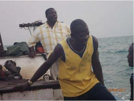
The objective of the LEK is to discover patterns of belief that can be separated into cultural domains that can add new knowledge about Sardinella, fishing and environments. Four focus group discussions (FGD) were conducted by staff from Hen Mpoano from May to July 2016 in different fishing communities: New Takoradi (Western Region), Elmina (Central Region), Tema New Town (Greater Accra Region), and Abutiakope (Volta Region). A total of 105 fishermen attended the FGDs. FGDs were held to collect initial data for the
development of the survey instrument to be used for the one-on-one data collection (Figures 2 and 3).
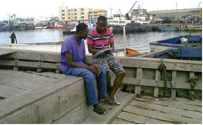
Following the FGDs, semi-structured interviews were conducted with 84 fishermen in 7 selected fishing communities (25 in the Western Region; 27 in the Central Region; 17 in the Greater Accra Region, and 14 in the Volta Region). The respondents were made up of fishermen who were identified as being knowledgeable about Sardinella. Both opportunistic and snowballing non-random sampling strategy were used based on availability and
willingness of individuals to participate in the survey in the selected communities
The individual interview responses were compiled and analyzed as qualitative data and then quantitatively evaluated using cross-tabulation chi square, factor analysis, free list and consensus analysis. The objective of this analysis is to discover the content and the structure of domains- what goes with what and
how they go together. It enables us to describe the interwoven linkages between themes and people and places (Bernard et al., 2017). It is not the study of people themselves but rather of culture, cultural norms and consensus. Consensus analysis allows for analysis of inter-cultural
variability and placement in a cultural domain. The “truth” for one person may not be the “truth” for another.
The LEK in this document is organized into boxes alongside appropriate scientific information to show agreement or disagreement with the SEK.
Incorporating LEK into the decision-making process and creating community based resource management systems can have many benefits. Eliciting and using LEK in the early stages of a management action can make the difference between perception of usefulness and
I hope that all that I ha
ve
contributed would go a long way to
benefit us all and sardinella would
o e i a u da e .
Ghanaian Fisherman
subsequent compliance. Local knowledge is not always accurate but it can be used to develop testable hypotheses that can confirm the reliability of the data. This combination should help to reduce uncertainty and build a more complete understanding of a complex environment. This document is organized into three chapters: the environment, the fishery, and the fish. The scientific information is compared to the local ecological knowledge and congruence is summarized in the table of the status of knowledge. Critical research gaps are identified based on agreement of knowledge.
Importance of Sardinella to Ghana
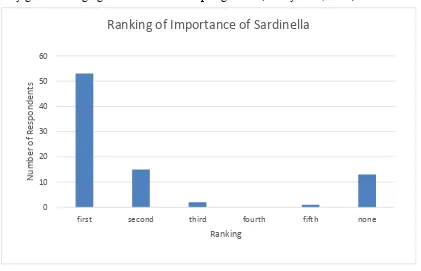
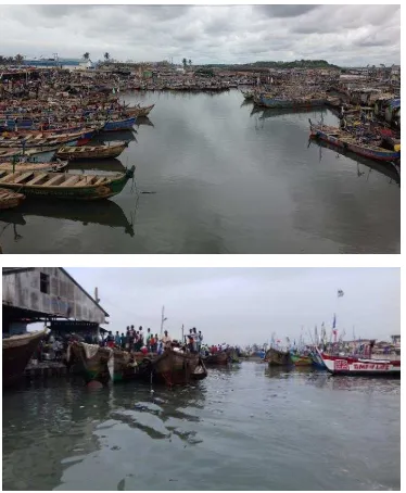
The importance of the Sardinella fishery to Ghana cannot be over emphasized (Figures 4 and 5). Ghanaians obtain nearly 10% of their total protein from fish (GSS, 2002). Both the coastal and inland dwellers are heavily reliant on fish. It is the cheapest animal protein available to Ghanaians, hence, consumed daily by a majority of the population (Heinbuch, 1994). Fish forms two-thirds of animal protein in the Ghanaian diet (Thorpe et al., 2004) making it three times higher than the world average consumption (WRI, 2003).
The small pelagic fisheries, which is the mainstay of the artisanal fisheries, in a good year contributes 70% of the total landings (MFRD, 2007). The local Ghanaian fish market is dominated by Sardinella, anchovy and chub mackerel which are small pelagics caught by the canoe and semi-industrial fishing fleets (Demarcq and Aman, 2002). It is estimated that Ghana’s 2030 population will require two times the current catch levels and fish imports. This projected fish demand can be met significantly by a sustainably managed Sardinella fishery given the high growth rates of small pelagic fish (Bailey et al., 2010).
0
first second third fourth fifth none
N
Ranking of Importance of Sardinella
“ If we do not fix the problems in t
he sardinella fishery there will be
unemployment and hunger; there will be no future and food for my kids”.
Fisherman from Half Assini
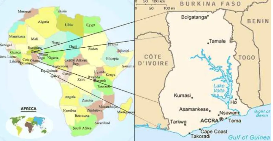
THE ENVIRONMENT
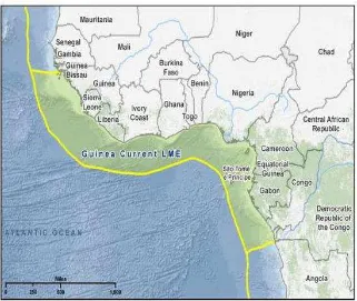
Ghana is located in the center of the West African coast (Figure 6). On the south, it borders the Gulf of Guinea and the Atlantic Ocean. The Guinea Current Large Marine Ecosystem (GCLME) extends from the Bissagos Islands to Cape Lopez and encompasses 16 countries from Guinea Bissau to Angola (Figure 7).
The productivity of the GCLME is affected by two major processes: nutrients from land drainage and rivers and turbulent diffusion through a stable pycnocline and periodic uprising of nutrient rich mid-depth water (Binet and Marchal, 1993).
Currents
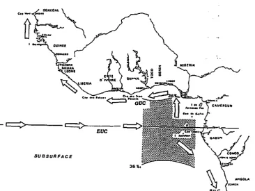
Two currents bring their waters to the Guinea Current (GC) along the coast of West Africa: the Equatorial Counter Current moving eastward and the Canary Current moving southwest (FAO 1990) (Figure 8). There are 2 major currents that flow along the coastline of Ghana, the Guinea Current and the South Equatorial Current. Closer to shore the Guinea Current flows from west to east, and the South Equatorial Current flows from east to west. The GC is not very deep-on average it extends from the surface to 15 m near the coast and 25 m
offshore. Underlying the GC is the Guinea Under Current (GUC) which originates from the Bight of Biafra as a return branch of the Equatorial Under Current (EUC) (Figure 9). The GUC starts out as a surface current but dives underneath the GC off the Ghana coast (Figure 10).
Source: http://www.justmaps.org/maps/africa/ghana/
Source: NOAA project office
(From Binet and Marchal, 1993)
Figure 7. Guinea Current Large Marine Ecosystem
Figure 8. Surface circulation in the eastern tropical Atlantic. NECC: North Equatorial Counter Current; GC: Guinea Current; SEC: South Equatorial Current. Hatched belt along the coast:
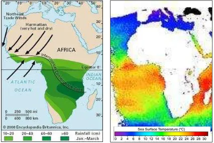
Wind and Rainfall
Wind and rainfall are major factors of environmental importance to the fisheries in Ghana controlling degree upwelling and nutrient enhancement. Ghana is only a few degrees north of the Equator, giving it a warm climate. It lies within the tropical belt at 4-12oN latitude and is heavily influenced by the West African Monsoon. The climate is characterized by a wet
Figure 9 Subsurface circulation in the eastern tropical Atlantic. EUC: Equatorial Under Current, GUC: Guinea Under Current; BUC: Benguela Under Current. Dotted region is the
area of the subsurface salinity maximum (>36x10-3) located around 50 m in depth
Figure 10 Longitudinal section of the zonal components of circulation off the Ivory Coast to Nigeria: 0-100 m profile on the continental shelf at 10-23 nm from shore; May 1972. Zonal
season and the dry season. The changing seasons have a significant impact on oceanographic conditions which effects marine resource distribution and fisheries.
North Ghana experiences its wet season from May to November. In the northern and central regions, annual rainfall is less than 1100 mm. Southwest Ghana is the wettest area
experiencing two wet seasons, one from March – July and the other in September and November. Annual rainfall in this area is 2000 mm (Asante and Amuakwa-Mensah, 2014). The greatest range in temperatures occurs in northern Ghana with an average temperature of 27-30oC in the dry season to 24-27oC in the wet season. In the south, the temperatures do not fluctuate as much between the dry and wet season with average temperatures reaching 25-27oC and 22-25oC respectively.
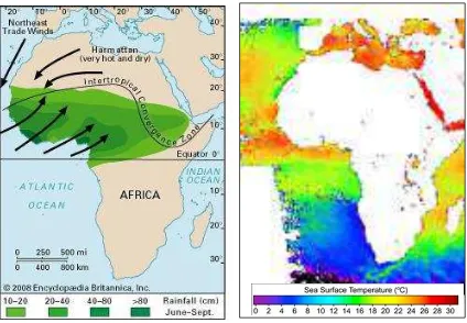
The wet seasons are influenced be the movement of the tropical rain belt (the Inter-Tropical Conversion Zone, ITCZ). In areas south of the ITCZ, south-westerly winds blow towards land bringing moist air from the Atlantic Ocean intensifying the Guinea Current. During the wet seasons squalls develop seasonally that correspond to coastal upwelling (Hagos and Cook, 2007). The upwelling zone becomes larger in winter and reduces in the summer and fall. In the wet season, the sea surface water temperature rises as upwelling becomes weaker (Figures 11a and b).
(From Encyclopedia Britannica, Inc., 2008 and http://fas.org/irp/imint/docs/).
North of the ITCZ, the dominant wind direction is from the northeast which brings a dry desert wind from the Sahara (known as the “Harmattan”). The shifting of these two prevailing wind directions over the course of a year is called the West African Monsoon (Fontaine and Bigot, 1993). During the dry season, sea surface water temperatures get colder
as upwelling increases and the dust from the Harmattan block sunlight from reaching the ocean’s surface (Figures 12a and b).
(From Encyclopedia Britannica, Inc., 2008 and
http://fas.org/irp/imint/docs/rst/Sect14/Sect14_11.html). Upwelling
In most current systems, wind can be the primary driver in upwelling events. However, the role of wind is not as obvious in the Guinea system. Two main upwelling cells are present (downstream of Cape Three Points in Ghana and downstream of Cape Palmas in Liberia).
However, this upwelling is still poorly understood. Djakoure et al., (2017) used a Regional Ocean Modeling System (ROMS) model to assess the role of the Guinea Current as a mechanism for the upwelling. The model simulations indicated that there were different mechanisms controlling upwelling east of Cape Palmas and east of Cape Three Points. The widening shelf east of Cape Palmas affects the influence of the coastal structures on the current dynamics and shallowing of the thermocline. Local wind effects and the large continental shelf appear to control upwelling east of Cape Three Points.
“The sea and the fish in it hav
e their seasons and it is how God designed it.
From November to January we have something called “harmattan” and
there is a type of fish that comes with that season (sardinella, moon fish).
During that time the seas become cold and it brings fish to the su
rface”
Fisherman from New Takoradi
Two seasonal upwellings occur along the continental shelf of Ghana, a major upwelling from late June/early July to September/early October, and a one month long minor upwelling during January or February (FRU/ORSTOM, 1976; Longhurst and Pauly, 1987; Mensah and Koranteng, 1988). During the major upwelling period the surface temperature (SST) drops from 25° C to 17° C or less, which brings nutrient rich waters to the surface for Sardinella aurita, Sardinella maderensis and other species. There is evidence for continuous upwelling offshore throughout the year, however the gradients are most pronounced from June to October with the coolest temperatures occurring in August and September (Bakun, 1978). In the summer, the temperature decreases as the GC moves east to an absolute minimum east of Cape Three Points however there are two areas where temperature increases abruptly: Cape Palmas and Cape Three Points (Bakun, 1978).
Climate also affects the conditions for fish production. Koranteng and McGlade (2001) found three distinct climatic periods (before 1972, between 1972-1882 and after 1982 in which both surface and bottom temperatures and salinities varied as a result of environmental changes (Figure 13).
They described a very strong relationship between time periods and S. aurita landings with high landings during the initial colder period before 1972; a collapsed phase between 1973-1982 and a recovery phase after 1973-1982.
Figure 13. Climatic periods of temperature and salinity in the Gulf of Guinea. Plots were obtained from calculating temperature and salinity anomalies using extracted trend values as
But when looked at regionally using free list analysis, there were differences of opinion on the ranking of factors (Table 1).
Table 1. Fishermen responses when combined by region, noted water temperature and rain as being the primary factors controlling sardinella abundance (proxy for upwelling) based on
their location.
The western area (west of Cape Three Points) identified air temperature, while those east of Cape Three Points (Central region) identified water temperature as the driver. Wind was not listed as a primary factor.
Rain is also identified as a strong environmental driver. Fishermen from Accra and Volta rated it highly. The strongest association was with those fishing 1-10 years and 31-40 and 41-50 years (Table 2) and beach seines and gillnets (Table 3).
Environmental Factor Freque
Wa ter tempera ture 50.6 1.85 0.37 62.5 2.13 0.406 50.6 1.85 0.369 26.7 1.5 0.2 35.7 2 0.268 Ra i n 49.4 1.95 0.35 54.2 1.92 0.372 49.4 1.95 0.345 60 1.89 0.461 64.3 2 0.435 Ai r tempera ture 43 1.97 0.31 66.7 1.44 0.569 43 1.97 0.308 53.3 2.63 0.317 35.7 2.2 0.226 Storms /wi nd/wa ves /ca l m s ea 46.7 2.14 0.317 42.9 1.67 0.339
Volta
All Western Central Greater Accra
“Round sardines like cold water while the flat like warm water”
Fisherman from the Accra Region
Figure 14. Fishermen responses when combined by region, noted water temperature and rain as being the primary factors controlling sardinella abundance.
46 OTHER (WHALES, CLIMATE CHANGE, DYNAMITE, HIGH SUN, SEASONS, WATER QUALITY, POLLUTION)
Number of Responses
Fa
ct
o
rs
Main environmental factors that affect the size, quality, and distribution of sardinella
Table 2. Free list analysis of environmental factors split by years fishing category.
Table 3. Free list analysis of environmental factors evaluated by gear type.
No fisherman was able to describe the relationship between wind, current, air and water temperature and upwelling.
Bottom Topography
The continental shelf of Ghana covers an area of 22,500 km2. Its depth ranges from 24 km to 80 km offshore (Figure 15). The shelf is widest between Takoradi and Cape Coast extending to 100 km but narrows to its minimum width of 20 km as it heads east to Cape Saint Paul (Figure 15) (Bernaczek, 1986). At depths of 10 to 50 m, the bottom type is a mix of hard and rocky bottom to soft bottom (mud to sandy mud) (Buchanan, 1957). There is a section of dead madreporarian corals that starts at 75 m and runs throughout the shelf. Beyond the coral, the bottom falls off abruptly marking the start of the continental slope. The coastline and coral belt are comprised of soft sediment while the area between Takoradi and Tema is primarily hard bottom containing flat rocks and shoal covered by large branched corals and briozoons (Rijavec, 1980; Bannerman and Cowx, 2002). Corallinaceous algae covers the areas of mixed gravel and pebble.
Environmental Factor Freque Wa ter tempera ture 50 1.75 0.38 53.8 1.86 0.41 57.1 1.75 0.414
Food 37.5 2 0.25 40 1 0.4
Ai r tempera ture 50 1.54 0.42 35.7 2 0.256 50 2.4 0.308 Storms /wi nd/wa ves /ca l m s ea 42.3 2.18 0.282
Currents /ti de 30 1.67 0.233
Years 1-10 Years 11-20 Years 21-30 Years 31-40 Years 41-50
Environmental Factor Freque
Wa ter tempera ture 40 1.75 0.3 41.7 1.6 0.347 57.8 1.96 0.398
Ra i n 50 1.8 0.39 66.7 1.75 0.5 48.9 2 0.337
Ai r tempera ture 50 2 0.33 37.8 2.24 0.243 77.8 1.29 0.722
Storms /wi nd/wa ves /ca l m s ea 33.3 1.67 0.259
Currents /ti de 41.7 2.4 0.257
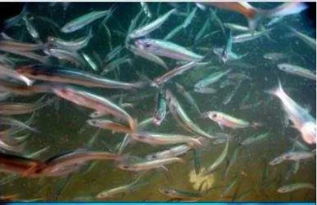
Although sardinella are pelagic, they do spend a great deal of time on or near the bottom feeding on small planktonic invertebrates, fish larvae and phytoplankton (Figure 16).
THE FISH AND THE FISHERY
Two Main Species
The two-main species of sardinella found off the coast of Ghana are the Round Sardinella, Sardinella aurita (Valenciennes, 1847) and the Flat Sardinella, Sardinella maderensis (Lowe, 1839) (Figure 17). Based on landings, S. aurita is generally considered to be of more
Figure 16. Small pelagic fish feeding on plankton
commercial importance than S. maderensis (Figure 18). However, catches of S. aurita have significantly dropped in the past 15 years whereas those of S. maderensis have remained relatively constant with a few highs and lows. S. maderensis is caught year-round and S. aurita is mostly caught during the upwelling periods (June-Sept) (Dec-Mar). These two species belong to the family Clupeidae and are coastal small pelagic species that inhabit warm waters preferring temperatures of 24 degrees C.
Local Knowledge: When do you find sardinella in abundance?
When all respondents’ answers were combined the time range of sardinella is from June through January (not found in the months of February through May) but they are mostly found between the months of July through September. When sorted by the home port of the respondents, the abundance time range widens as you move east; in the western range sardinella are only found during the months of June through September, and as you move east, the range expands. In the Volta region the range is from June through January however, both species are found in this area (Figure 19 a and b).
The is a significant correlation between when the fishermen land their catch and their perception of abundance by season (Chi Square= 18.89, p = 0.004). A partial correlation between region and gears fished showed a significant effect between region and abundance only (Kendalls tau = 0.349, p = 0.000).
1960 1970 1980 1990 2000 2010 2020
La
Sardinella landings in Ghana (1963-2015)
Ghana S.aurita Ghana S maderensis
Figure 19. a. and b. The perception of abundance of sardinella is affected by region fisherman is from and although gear may play a role, it does not have a significant effect.
The S. aurita fishery in Ghana is considered seasonal and occurs mostly from July to September coinciding with a major upwelling period. There are also some landings during the minor upwelling period of January to March (Mensah 1991). Upwelling starts the production cycle needed for sardinella survival. Phytoplankton, zooplankton and larval fish are the primary diet for both S. aurita and S. maderensis.
A. Times of sardinella abundance
Local Knowledge: Landings
There was an overwhelming agreement in regards to the state of the sardinella population and 94% of respondents agreed that the population is decreasing in the waters where they fish and 88% said there was a decrease in the overall waters of Ghana. But in the Volta region, respondents stated there was an increase in the population in the areas where they fish.
0 10 20 30 40 50
Purse Seine Beach Seine Gillnet Trawl
N
u
m
b
e
r
Gear Type
b. Abundance by Gear
The LEK did not distinguish between the two species of Sardinella. Therefore, this is general information about the two species that fishermen have observed.
The majority of fishermen listed “abundance” as one of the unique characteristics of sardinella (Figure 21). This characteristic appears to be the most at risk as most fishermen claimed abundance was decreasing.
Fishing Gear and Methods
There are many gear types used to harvest sardinella in Ghana. They are harvested by subsistence fishermen in the coastal lagoons and beaches; artisanal fishermen from canoes and semi-industrial vessels and by industrial vessels as bycatch. Landings by gear type has not been available except for specific studies (such as for the Central region by Bampoe, 2011) (Table 4).
Table 4. Assemblages of prey by gear (Bampoe, 2011). APW = Ali-Poli-Watsa (purse seine) and STN= set net in the Central Ghana area.
Common
Name Jan Feb Mar Apr May June July Aug Sept Oct Nov Dec
Madeiran
sardinella APW STN APW STN APW STN APW STN APW STN STN APW APW STN APW STN APW STN APW STN APW STN STN
Round
sardinella APW STN APW STN APW STN APW STN APW STN STN APW APW STN APW STN APW STN APW STN APW STN APW STN
Local Knowledge: Prey
When fishermen were asked what they thought sardinella ate, the top answer was anchovy followed by small shrimp/animals. However, those fishermen with the most years of experience, 41-50 years, agreed that sardinella eat small particles and not anchovy.
Marquette et al. (2002) describes several gear types as targeting sardinella in Moree: set nets (tenda adado), Drift nets (ali and libias) and beach seines.
a. beach seining b. catch from beach seine
Figure 22 a-b. Beach seine and fishing gear photos
0
c. gill net. d. gill net
e. purse seine. f. purse seine with light boat on top
g.trawl net. h.trawl door that keeps the spread open on the bottom
The following are some available general descriptions of the gears (Table 5) but see CRC publication (In press) for more updated information.
Table 5. General gear description (FAO 2011).
Gear Material Mesh sizes double or triple netting walls, vertical, near by the surface, in midwater or on the bottom, in which fish will gill, entangle or enmesh. Set nets have floats on the upper line (headrope) and, in general, weights on the ground-line (footrope). Set nets or consist in single or, less commonly, double (both are known as
"gillnets", strictly speaking) or triple netting (known as "trammel net") mounted together on the same frame ropes. Several types of nets may be combined in one gear. These nets can be used either alone or, as is more usual, in large numbers placed in line ('fleets' of nets). The gear can set, anchored to the bottom or left drifting, free or connected with the vessel. Purse
seine Synthetic multifilament 25 – 50 The purse net is a surrounding net. The size of the net varies but is generally in the region of 400 to 600 meters in length and 35 to 50 meters deep. The net has a minimum mesh size of 25 mm in the bunt while the rest of the net is constructed of a variety of meshes up to about 50mm in size.
Trawl Nylon
multifilament 50 – 60 The trawl nets are cone-shaped net (made from two, four or more panels) which are towed, by one or two boats, on the bottom or in midwater (pelagic). The cone-shaped body ends in a bag or coded. The horizontal opening of the gear while it is towed is maintained by beams, otter boards or by the distance between the two towing vessels (pair trawling). Floats and weights and/or hydrodynamic devices provide for the vertical opening. Two parallel trawls might be rigged between two otter boards (twin trawls). The mesh size in the codend or special designed devices is used to regulate the size and species to be captured. Beach
Local Knowledge: Gear types
The majority of those interviewed were purse seiners (59%); other main gears included beach seine, gillnet, and trawl. Many fished with more than one type of gear. Sardinella was the primary target species of the purse seiners and gillnetters (69% and 47%, respectively). 30% of the beach seiners targeted sardinella and anchovy; 22% of the trawlers targeted sardinella (burrito was the primary species targeted by the trawlers, 33%).
Figure 24. a and b. Type of fishing conducted and target species
0
Species 1 Species 2 Species 3
0
purse seine beach seine gillnet /
setnet
trawl Ring net seabird net
Management
Under the decentralization reforms in the 1980 and the early 1990s, many central government responsibilities were shifted to the District Assemblies (DAs) with limited success. In 1997, community based fisheries management committees were initiated as part of a World Bank project. The objective of this initiative was for artisanal communities to develop the capacity to formulate and adopt constitutions with stringent by-laws with financial and practical support and legal backing from the DAs. However, most of these collapsed soon after the project was terminated. The principal reason given was that they were conceived and planned with little real input from the people themselves. The present emphasis is on developing a new co-management approach through the creation of District Fisheries Management Committees and the reorganization of the local community groups with a strengthened Fisheries Act (Finegold et al., 2010).
The perception of power plays a huge role in management. The success of co-management hinges on an incentive structure (ec0nomic, social, political) that induces various individuals to participate. The co-management process often involves giving up individual short-term benefits for real or perceived long-term benefits and involves great personal loss (Pomeroy et al., 2001). The LEK focused on evaluating the investment in management which was assessed using a ranking analysis approach then evaluating significance through a Chi-Square test. Several indicators were used:
A. If parents fished; B. If they were part time
C. If they belonged to a fishing organization
D. If they thought their children should go fishing if the fishery improved E. If any change in perception between above and if the fishery did not improve F. Current participation in management
G. Knowledge of existing organizations
Table 6. The average responses for each variable of each ranking group
There are fishermen who are more invested in management than others. Based off this preliminary assessment, those who belong to organizations may be more invested in the future of the fishery. Additionally, younger/ less-experienced fishermen surprisingly seem to have a higher investment. This may be attributed to the fact that they will have a higher
0
dependency upon the fishery than older fishermen as they will have to continue working over a longer period of time. Also coming from a fishing family may have a strong influence on investment in management. Respondents from Tema/ Canoe Beach and New Takoradi displayed a higher pessimism for the future of the fishery. This finding may be attributed to the fact that Tema/Canoe Beach had the highest number of respondents’ that are involved in an alternative livelihood, however, there were very few respondents from New Takoradi who were involved in an alternative livelihood. This may indicate that there is greater
overexploitation of the fishery in this region.
The chiefs were noted as being the important decision makers at local and regional levels (Figure 24) yet the majority of respondents could not identify the fishing associations involved in management (Figure 25).
0 10 20 30 40 NONE
GNCFC FISH PROCESSERS ASSN GIFA SMALL UNITS (EWE FISHING CO; HOFO BEACH ASSN) PREMIX COMMITTEE NET/BOAT OWNERS/ SAILORS/SECURITY CANOE COUNCIL, LANDING BEACH, CHIEF …
DOES NOT KNOW
Number of Respondents Are there Fishing Associations or Organizations?
“Our talk with you-
when will it end? I’m asking because for us to revamp the
fisheries we need to depoliticize the fisheries. Fishermen are not politicians.
We were interested in the fish and had no time to vote when there is fish to be
caught. You learned folks introduced us to politics, you convinced us to
engage in it and now it has messed up the fisheries. If it is not taken out, you
guys can bring all the intervention but it will not work. When politics is taken
out of fisheries and we fishermen go about our fishing duty then the
government can bring the laws and tell us whether we vote for them or not.
This is what the law says and we will on the basis of that obey. Take our words
to those that matter, tell them the politicians are using us fishermen as scape
goats for their political benefit”
Fisherman from New Takoradi
The Round Sardinella: Sardinella aurita Distribution
The overall range of S. aurita extends to the western and eastern Atlantic Ocean, the Mediterranean and Black Seas (Figure 26) (Smith and Sandwell, 1997). The stock off the Ivory Coast and Ghana extends from off Jacqueville in Ivory Coast to Port Seguro in Togo (Anon, 1976).
S. aurita is a highly migratory species. The bulk of the stock winters at depths from 50 to 80 m off central Ghana (Zei, 1962; Anon, 1976; Koranteng, 1989; Brainerd, 1991). Around July and August, when the coastal upwelling begins, the fish migrate towards the coastal areas of the Ivory Coast and western Ghana (Zei, 1966; Brainerd, 1991; Koranteng, 1995). This is when the fishing season begins as the fish are accessible. Approaching the coast, they turn eastward and continue to Togo and Benin (Anon, 1976; Koranteng, 1989). At the end of the season, in October through December they return to deeper waters and resting grounds for wintering (Brainerd, 1991).
Off West Africa, the species is considered to comprise of three distinct “stocks”. These are the North Transitional Zone from Mauritania to Guinea, the Central Upwelling Zone located along the Ivory Coast and Ghana, and the South Transitional Zone from southern Gabon to Southern Angola (Whitehead, 1985). However, Koranteng (1989) offers doubts as to whether there indeed exists separate stocks off Cote d’Ivorie and Ghana. This is due to the migratory pattern of S. aurita as described above. There is another school of thought and that is that there are two separate stocks, one located on the eastern side of Cape Three Points and
the other on the western side of the Cape Three Points (Koranteng, 1989; Koranteng, 1995; Binet and Marshall, 1993) (Figure 27).
S. aurita can be found from inshore and near surface down to 350 meters or deeper (Whitehead, 1985).
Figure 28. The map shows fishery divisions along Cote d’Ivoire and Ghana. Black dots correspond to the barycenters of the two populations of Sardinella aurita (Binet et al., 1991 as
reported in Binet and Marchal, 1993).
A hydrodynamic model was developed by Kone et al. (2016) for the Gulf of Guinea and produced a realistic environmental picture of S aurita spawning and larval retention. Two spawning areas were found to be favorable to larval retention and survival – Cape Palmas and Cape Three Points. They produced a conceptual model of the early life history of S. aurita (Figure 28). A LEK map was also generated (Figure 29).
Growth and Maturity
The modal length size of the S. aurita in Côte d’Ivoire was between 15 cm and 18 cm in the sixties and seventies. In the 1980s, this modal size increased to 18 cm and 24 cm. In Ghana, a similar increase in length was observed between the early 1960s (14 cm -17 cm) and the 1980s (17cm - 21 cm). S. aurita is known to grow isometrically (b=2.90) in the Gulf of Guinea. As compared to S. maderensis, it is a slower growing species and has a smaller von Bertalanffy growth coefficient (K) = 0.51 and is also longer living, longevity was estimated at 5.9 years (Elmina samples).
Figure 30. Local Knowledge map produced by the fishermen of Moree.
Fishermen stated that sardinella do not literally move from west to east of Ghana but that the food moves. The appearance of sardinella coincides with upwelling and the sardinella moves from off the continental shelf towards the shelf as the upwelling begins. Fishermen in the western regions encounter fish first because their coast extends further into the sea than that of Volta and Accra (Figure 30). They move in relation to the shape of Ghana- they travel using the continental shelf as their route.
Local Knowledge: Size
Figure 31. Nature of Ghana's coastline
Males mature sexually at a smaller size than the females (Tsikliras and Antonopoulou, 2006). The length at first maturity of the S. aurita in Côte d’Ivoire seems to have increased from 15 cm in the 1960s and 1970s to 18-19 cm at the end of 1980s to 19-20 cm in 1990s (attributed to increasing impact of the minor upwelling on the ecosystem). The female population maturity size off Ghana was reported to have increased from 14.5 cm to 17.1 cm (Quaatey and Maravelias, 1999). Samples taken at Elmina determined that the length at sexual maturity of S. aurita was 16.40 and 16.74 cm (total length) for males and females, respectively.
Spawning
The spawning of S. aurita is synchronized with the occurrence of the major upwelling (July - September) (Bakun, 1996; Lett et al., 2006) and maximum production of phytoplankton (Arístegui et al., 2006; Fréon et al., 2006). Minor sporadic spawning can occur during the minor upwelling (Mensah and Koranteng, 1988). It is able to spawn in any favorable conditions and consequently there is two possible recruitments per year.
Some reports noted that this species could spawn outside the upwelling season (Pezennec and Koranteng 1998; Quaatey and Maravelias, 1999) and Koranteng (1989) noted that eggs and larvae of Sardinellas species are found almost year-round suggesting that the species spawns year-round; however, there was a higher abundance found during upwelling periods.
Fecundity showed a significant positive correlation with total length and body weight. For S. aurita, fecundity ranged from 4,834 to 63,917. A study done off Elimina looked at the
occurrence of different gonadal stages of males and females of (Osei, 2015). They
found that both sexes had similar patterns and reported on Stages II to V. They also found that the highest abundance of resting / recovering spawning (Stage II) males and females occurred from October to December with peaks in November (Figure 31). Pre-spawning (Stage III) males and females increased in proportion from October to February with the majority found in February suggesting that Stage II animals of the previous month were developing into Stage III. Spawning (Stage IV) males were observed from February to September with maximum abundance found in July. Stage IV females were highest in March and April with a peak in July to September. Post-spawning (Stage V) males and females peaked in June.
The Flat Sardinella: Sardinella maderensis
Distribution
Source: Osei, 2015.
As seen in Figure 32, S. maderensis are found in the Mediterranean Sea (southern and eastern parts, also penetrating Suez Canal) and the Eastern Atlantic Ocean (Gilbraltar southward to Angola and a single recorded specimen from Walvis Bay, Namibia) (Whitehead, 1985). This species is widely distributed in the Gulf of Guinea and the Eastern Central Atlantic (Cury and Fontana, 1988). Largest concentrations are found off the Ivory Coast and Sierra Leone (Zei, 1966).
The movements of S. maderensis are correlated with seasonal upwelling (Froese and Pauly, 2002). This species is known to be strongly migratory, however, movements in the central stocks along the Ivory Coast and Ghana are not so marked and it is considered more of a coastal species and relatively sedentary with limited seasonal migrations along the coast (Cury and Fontana, 1988).
S. maderensis is found from the surface down to 50 m (Whitehead, 1985).
Growth and Maturity
As with S. aurita, the same is true with S. maderensis in that males mature sexually at a smaller size than the females (Youmbi et al., 1991). Samples taken at Elmina determined that the length at sexual maturity for S. maderensis was 15.43 and 15.56 cm (total length) for males and females, respectively.
This species also grows isometrically in the Gulf of Guinea (b=2.77). It grows faster than S. aurita, higher von Bertalanffy growth coefficient (K) = 0.6, and is expected to live up to 5 years (Elmina study; Osei, 2015).
Spawning
S. maderensis breeds once a year during the warm season (July to September) in coastal waters (Minta, 2003).
Fecundity showed a significant positive correlation with total length and body weight. For S. maderensis, fecundity ranged from 7,597 to 33,984 (fish studied at Elmina).
A study done off Elmina looked at the occurrence of different gonadal stages of males and females of S. aurita (reported above) and S. maderensis. For both species they found that both sexes had similar patterns and reported on Stages II to V. For S. maderensis it was found that the highest abundance of resting / recovering spawning (Stage II) males and females occurred from October to November (Figure 33) and peaked again in May. Pre-spawning (Stage III) males increased gradually from October to a peak in March and declined sharply in May to another peak in July. Stage III females increased from October to a
maximum in March and then declined. Spawning (Stage IV) males only occurred in 7 of the 12 months sampled, peaking in September. Stage IV females were observed only from April to September, also peaking in September. Post-spawning (Stage V) males were only present in June and September and at very low values and females were present from May to
SOME IMPORTANT POINTS
Validation activities were conducted in December 2016 and January 2017 in 7 communities by the staff of Hen Mpoano. At the meetings, the results of the surveys were presented and an opportunity was given to the fishermen to explain their views. This step is one of the most important in education and outreach for co-management. Often, the information in the LEK was confusing because of context or vocabulary. Without the ability to discuss these issues,
“Once you get what you are looking for from us that is the end. We don’t
hear from you again”
Fisherman from Elmina
the information can be misinterpreted. Just as with SEK, peer review is a critical step in assessing the validity of the information collected.
STATUS OF KNOWLEDGE
The following table summarizes the two sources of information and whether or not there is agreement between the sources of knowledge.
Table 7 Comparison between local knowledge and scientific knowledge
Area Scientific Knowledge Local Knowledge Agreement?
Environment however it is large scale rather than place specific.
Place specific knowledge Can be combined for greater
understanding
Currents Some information
available Should explore further Fishery
Gear We have not seen any recent data on the fishery. Published information is outdated.
The fishery has changed a great deal in the last two years. The transshipment of sardines from the trawlers to shore fishery has become one of the largest providers of product. The catch for the other gears has dropped.
No
Landings Published This product is not
counted as landings. No Fish
Species Information available. Landings data sometimes combines and sometimes does not.
Could use more
information from the local areas.
Yes
Abundance Information available from acoustic surveys
Movement Some research and modeling on
Prey Information available Experience dependent Only more experienced Management Perception of
co-management being done
Perception of not being included in decision making
RESEARCH GAPS
Based on the comparison, there are several areas that would benefit from further outreach, education and research:
A. Need for new supply and value chain analysis. B. Update gear design and fishing methods. C. More research on movement and currents. D. Education on fish life history at fisherman level.
E. Need for more on the ground interaction with fishermen through collaborative research and extension.
REFERENCES
Anon., 1976. www.aquamaps.org. Reviewed distribution maps for Sardinella aurita (Round sardinella), with modelled year 2100 native range map based on IPCC A2 emissions scenario. www.aquamaps.org, version of Aug. 2013. Web. Accessed 29 Jul. 2016. Arístegui J., X.A. Alvarez-Salgado., E.D. Barton, F.G. Figueiras, S. Hernandez-Leon, Roy
Claude, A.M.P Santos. Chapter 23: oceanography and fisheries of the Canary current/Iberian region of the eastern North Atlantic (18a, E). In: Brink K.H. (ed.), Robinson A.R. (ed.) The sea: the global coastal ocean: interdisciplinary regional studies and syntheses. Harvard: Harvard University Press, 2005, p. 877-931. ISBN 0-674-01527-4
Asante, F.A. and F. Amuakwa-Mensah. 2014. Climate change and variability in Ghana: Stocktaking. Climate, 3(1): 78-99.
Bailey M., Quaatey S., Armah A. K., Jacquet J., Khan A., Alder J. and Sumaila U. R. 2010. Chapter 14: Meeting socioeconomic objectives in Ghana’s sardinella fishery. In: Nanang D. M. (ed) and Th. K. Nunifu. Natural Resources in Ghana. Nova Science Publishers, Inc., 2010, pp. ISBN 978-1-61668-020-6
Bakun, A. 1978. Guinea Current Upwelling. Nature 271:147-150.
Bakun, A. 1996. Patterns in the ocean: Ocean processes and marine population dynamics. University of California Sea Grant, San Diego, California, USA, in cooperation with Centro de Investigaciones Biológicas de Noroeste, La Paz, Baja California Sur, Mexico.
Bampoe, A. A. 2011. Classification of artisanal fisheries métiers in Ghana: a case study of the Central region. Masters Thesis, University of Tromsø UiT, Norwegian College of Fisheries Science. 80 pp.
Bannerman, P.O. and I.G. Cowx. 2002. Stock assessment of the big eye grunt
(Brachydeuterus auritus, Val.) fishery in Ghanian coastal waters. Fish. Res., 59:
197-207.
Bernacsek, G.M., 1986. Profile of the marine resources of Ghana. CECAF/TECH/71 FAO, 1986, 118 pp.
Bernard, H.R., Wutich, A. and G.W.Ryan. 2017. Analyzing qualitative data: Systematic approaches. Second edition, Sage Publishing 552 pps.
Binet, D. and Marchal, E. 1993. The large marine ecosystem of shelf areas in the Gulf of Guinea: Long-term variability induced by climatic changes. In: Sherman, K., L.M. Alexander and B.D. Gold (eds.), Large Marine Ecosystems. Stress, mitigation, and sustainability. AAAS Press, Washington, pp. 104–118.
Brainerd, T.R. 1991. The sardinella fishery off the coast of West Africa: The case of a common property resource. Paper presented at the Second Annual Conference of the International Association for the Study of Common Property (IASCP), University of Manitoba, Winnipeg, Canada.
Buchanan, J., 1957. Benthic fauna of the continental edge off Accra, Ghana. Nature London 179, 634-635.
Cury, P. and A. Fontana. 1988. Compétition et stratégies démo- graphiques compares de deux espèces de sardinelles (Sardinella aurita et Sardinella maderensis) des cotes ouest- africaines. Aquat. Living Resour., 1, 165-180.
Djakoure, S., Penven, P., Bourles, B., Kone, V., and J. Veitch. 2017. Respective roles of the Guinea current and local winds on the coastal upwelling in the northern Gulf of Guinea. J. of Physical Oceanography 47(6): 1367-1387.
Doyi, B. A. 1984. Catalogue of Small-scale fishing gear of Ghana. CECA/ECAF Series 84/31 (En), Food and Agriculture Organisation, Rome. 71 pp.
FAO. 2011. Fishing with beach seines. FAO Fisheries and Aquaculture Technical Paper. No. 562. Rome, FAO. 2011. 149pp.
FAO. 1990. The “Guinea 90” Survey. Fishery Committee for the Eastern Central Atlantic. CECAF|ECAF Series 91|52. Food and Agriculture Organization of the United Nations Rome, 1991.
Finegold, C., Gordon,A., Mills, D., Curtis, L and A. Pulis. 2010. Western Region Fisheries Sector Review. World Fish Center, USAID Integrated Coastal and Fisheries
Governance Initiative for the Western Region. Ghana. 84 pps.
Fisheries Research Unit/Office de Recherche Scientfique et Technique pour le
Développement en Coopération [FRU/ORSTOM]. 1976. Rapport du groupe de travail sur la sardinelle (Sardinella aurita) des Côte d'Ivoire Ghaéennes. ORSTOM, Abidjan. 32 pp.
Fontaine, B. and S. Bigot. 1993. West African rainfall deficits and sea surface temperatures. International Journal of Climatology, 13(3), 271-285.
Fréon, P., J. Alheit, E.D. Barton, S. Kifani, and P. Marchesiello. 2006. Modelling, forecasting and scenarios in comparable upwelling ecosystems: California, canary and Humboldt. In: G. Hempel, C. Moloney, P. Rizzoli, and J. Woods. (Eds.). The Benguela:
Predicting a Large Marine Ecosystem. Elsevier Series, Large Marine Ecosystems. Vol 14:185–220.
Froese R. and D. Pauly. 2002. FishBase. Worldwide Web Electronic Publication.
(www.fishbase.org)
GSS. 2002. 2000 Population and housing census of Ghana. Summary report of final results. Ghana Statistical Service, March 2002. 16 pp.
Hagos, S. M. and K.H. Cook. 2007. Dynamics of the West African monsoon jump. Journal of Climate, 20(21), 5264-5284.
Heinbuch, U. (1994). Animal protein sources for rural and urban populations. FAO Technical Report 58. 39 pp.
Jelavic, M. 2010. Knowledge management views in eastern and the western cultures: An integrative analysis. J. of Knowledge Globalization 3(2):51-69.
Johannes, R.E. 1977. Traditional law of the sea in Micronesia. Micronesia 13: 121-127. Johannes, R.E. 1978. Traditional marine conservation methods in Oceania and their demise.
Annual Review of Ecology and Systematics 9:349-364.
Johannes, R.E., Freeman, M.M.R., and R.J. Hamilton. 2000. Ignore fishers knowledge and miss the boat. Fish and Fisheries 1: 257-271.
Kone, V., Lett, C. Penven, P., Bourles, B. and S. Djakoure. 2016. A biophysical model of S. aurita early life history in the northern Gulf of Guinea. Progress in Oceanography (in press).
Koranteng, A.K. 1989. The Sardinella (Herring) Fishery in Ghana, the Past, Recent Development and the Years Ahead. Information Report Number 23, Fisheries Department Research and Utilization branch Tema, Ghana. 38 pp.
Koranteng, A. K. 1995. The Ghanaian Fishery for Sardinellas. Fisheries Department, Research and Utilization Branch, Tema, Ghana.
Longhurst, A.R. and D. Pauly. 1987. Ecology of Tropical Oceans. Academic Press, San Diego. 407 pp.
Lett, C., C. Roy, A. Levasseur, C. D. Van Der Lingen, and C. Mullon. 2006. Simulation and quantification of enrichment and retention processes in the southern benguela
upwelling ecosystem. Fish. Oceanography 15:363–372.
Marquette, K.M., Koranteng, K.A., Overa, R., and Aryeetey, G. 2002. Small-scale fisheries, population dynamics, and resource use in Africa: The case of More, Ghana. Ambio 31(4): 324-336.
Mensah, M. A. 1991. The Influence of Climatic Changes on the Coastal Oceanography of Ghana. ORSTOM, Abidjan.
Mensah M.A. and K.A. Koranteng. 1988. A review of the oceanography and fisheries resources in the coastal waters of Ghana, 1981 – 1986. Fisheries Research and Utilisation Branch, Fisheries Department, Tema, p. 35
MFRD. 2007. Marine Fisheries Bulletin for 2006. Marine Fisheries Research Division, Ministry of Fisheries, Tema. 24 pp.
Minta, O.S. 2003. An assessment of the vulnerability of Ghana’s coastal artisanal fishery to climate change. Thesis submitted in partial fulfilment of the requirements for the degree of Master of Science in International Fisheries Management.
Osei, I. 2015. Aspects of the biology of Sardinella aurita and Sardinella maderensis (Clupeidae) in the coastal waters of the central region, Ghana. MPhil Thesis, University of Cape Coast, Ghana.
Pezennec, O. and K.A. Koranteng. 1998. Changes in the Dynamics and Biology of Small Pelagic Fisheries off Côte-d'Ivoire and Ghana: an ecological puzzle. In: Durand Marie-Helene (ed.), Cury Philippe (ed.), Mendelssohn, R. (ed.), Pauly, D. (ed.) Global versus local changes in upwelling systems: ORSTOM, 1998. pp. 329 – 343.
Pomeroy, R.S., Katon, B.M. and I. Harkes.2001. Conditions affecting the success of fisheries co-management: lessons from Asia. Marine Policy 25: 197-208.
Quaatey, S.N.K. and C.D. Maravelias. 1999. Maturity and spawning pattern of Sardinella aurita in relation to water temperature and zooplankton abundance off Ghana, West Africa. J. Appl. Ichyol. 15:63-69.
Raymond, C.M., Fazey, I., Reed, M.S., Stringer, L.C. Robinson, G.M., and A.C. Evely. 2010. Integrating local and scientific knowledge fro environmental management. J. of environmental management 91:1766-1777.
Rijavec, L. 1980. A survey of the demersal fish resources of Ghana. CECAF/TECH/80/45. Smith, W. and Sandwell, D. 1997. Global sea floor topography from satellite altimetry and
ship depth sounding. Science 277 :1956–1962., 277 :1956–1962.
Thorpe, A., Reid, C., Van Anrooy, R., & Brugene, C. (2004). African poverty reduction strategy programmes and the fisheries sector: Current situation and opportunities. Oxford, UK: African Development Bank. pp.338-362
Tsikliras, A. C. and E. Antonopoulou. 2006. Reproductive biology of round sardinella (Sardinella aurita) in the north-eastern Mediterranean. SCI. MAR., 70(2), 281-290. WRI. 2003. World Resources Institute Earthtrends. Country Profile for Coastal and Marine
Ecosystems: Ghana.
Whitehead, P. J. P. 1985. FAO Species catalogue Vol. 7. Clupeoid fishes of the world. An annotated and illustrated catalogue of the herrings, sardines, pilchards, sprats, anchovies and wolf-herrings. FAO Fish. Synopsis.
Zei, M. 1962. Marine fisheries Research Ghana – Its Scope and Development in 1962, pp 1-4. In: Fisheries Research Report vol. 1 No. 1 Fisheries Inspectorate Unit, Accra. Zei, M. 1966. Sardines and related species of the Easter Tropical Atlantic. Pro. Symp. On the