Drawing Louisiana’s New Map
A Review of Restoration Plans in Coastal Louisiana
During the past 50 years, coastal Louisiana has suffered catastrophic land loss due to both natural and human causes. This loss has increased storm vulnerability and ampliied risks to lives, property, and economies—a fact underscored by Hurricanes Katrina and Rita. This report reviews a restoration plan proposed by the U.S. Army Corps of Engineers and the State of Louisiana, inding that, although the individual projects in the study are scientiically sound, there should be more and larger scale projects that provide a comprehensive approach to addressing land loss over such a large area. More importantly, the study should be guided by a detailed map of the expected future landscape of coastal Louisiana that is developed from agreed upon goals for the region and the nation.
A
nnual land loss rates in coastal Louisiana have varied over the last 50 years, ranging from a high of 39 square miles per year for the period 1956–1978 to a projected rate of roughly 10 square miles per year for the period 2000 to 2050. Aware of the potential forcatastrophic land loss over the next 50 years and its possible impacts, the state of Louisiana and U.S. Army Corps of Engineers (the Corps) have been working on plans to slow or reverse land loss, and in 2004, released a restoration plan called the Louisiana Coastal Area Study (LCA Study). The LCA Study then proposed a series of projects and related activities that will span 10 years and cost an estimated $1.9 billion. As plans for completion of the LCA Study were being inalized, Louisiana’s Ofice of the Governor requested that the National Academies review the LCA Study for its scientiic merit and effectiveness for long-term, comprehensive restoration development and implementation.
This report was in the inal stages of peer review and was essentially complete at the time that hurricanes Katrina and Rita struck the Gulf Coast. Although it is not yet clear about the relative roles played by land loss, lack of levee maintenance, and large navigation channels in determining the extent of damage, what have become clear are the enormous personal, social, economic, and cultural losses that a major hurricane can cause. To the extent that wetlands can offset a signiicant degree of storm impact, large-scale wetlands restoration projects can be an important component of national efforts to reduce future hazards from hurricanes.
Upon reexamining the draft report following the hurricanes, the committee and the National Academies concluded that the report’s indings and recommendations regarding the restoration and protection efforts still stand and may be even more important today as federal, state, and local leaders make decisions about how to respond to one of the greatest natural disasters in U.S. history.
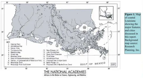
The Unique Challenges of the Louisiana
Coast
For millennium the wetlands of coastal Louisiana have been shaped by the processes of land loss and gain both through natural processes, and more recently through human activities in the wetlands and the watershed of the Mississippi River system. Coastal wetlands develop naturally within a ine balance of many geologic and coastal ocean processes including sea level rise, wave action, river discharges, and coastal storms. Sediment deposition and accumulation play particularly important roles in wetlands sustainability.
Because it lies at the mouth of the Mississippi River, coastal Louisiana naturally experienced high rates of sediment deposition, which had allowed the delta to develop. Once humans began to alter the low of river water and the sediment it carried, sediment deposition was generally reduced so that land building was no longer able to keep pace with natural subsidence and global sea level rise.
Over the last two centuries, lood control, and construction and maintenance of navigational waterways have in general prevented the
Mississippi River from depositing sediment through natural processes, reducing the potential for the growth of new wetlands. Other human activities, such as oil and gas extraction, navigation canal and pipeline dredging, construction of levees with a resulting loss of loodplain lows and the introduction of nonnative fauna have also contributed to wetland loss. Although there is some uncertainty regarding the relative contribution of natural vs. human activities, all of these factors have combined to produce land loss that has greatly increased vulnerability to storms and storm surges.
Plans Should Be More Comprehensive
The stated goal of the LCA Study is “to reverse the current trend of coastal ecosystem degradation.” Taken individually, the majority of the projects proposed in the LCA Study are based on commonly accepted, sound scientiic and engineering analyses. However, at foreseeable rates of land loss, the LCA Study efforts will likely decrease land loss only in areas adjacent to the speciic proposed projects and would not likely address coastal erosion at the scale of the affected area. The report recommends that the selection of any suite of individual projects include a clear effort to maximize the beneicial, synergistic effects of individual projects to minimize or reverse future land loss.
Implicit in the LCA Study is the goal to achieve no “net loss.” The report inds that this is not a feasible objective of the activities as currently formulated in the LCA Study because the sediment supply is limited, the affected area is large, and because there are extensive social, political, and economic impediments to achieving it. The LCA Study’s ive restoration projects would only reduce land loss by about 2 square miles per year. Louisiana’s coastal restoration plans must acknowledge these limitations prominently and adjust goals and public
expectations accordingly. In addition, restoration efforts should be focused to maximize targeted ecological, social, and economic beneits while promoting relocation in selected regions.
River Gulf Outlet (MRGO), a deep navigation channel that was built by the Corps as a shortcut for shipping to the Port of New Orleans. The project is problematic for two reasons. First, it would not go a long way to slowing or reversing land loss in accordance with LCA Study goals. Second, the Corps is carrying out analysis of the cost effectiveness of MRGO and may consider decommissioning it as a deep draft navigation channel once that analysis is completed.
Another project, known as the Third Delta, would divert water from the Mississippi River through a 65 mile-long conveyance channel to the west. The Third Delta could be a cost effective way to deliver large volumes of sediment. However, the proposed route of the conveyance channel would adversely impact a large number of stakeholders, increasing the cost of the project. The report suggests that an alternate plan be considered with a diversion much farther south, reducing the number of stakeholders impacted while also providing sediment that would more effectively nourish barrier islands.
Deining the Future Coastline
Planning and implementation of water resources projects, including those involving environmental restoration, should be undertaken within the context of the larger system. Because proposed projects must function for decades to deliver maximum beneit, care should be taken to ensure that implementation of an individual project does not preclude other strategies or elements that are being considered for the future. To achieve this, the development of an explicit map of the desired, future landscape of coastal Louisiana should be a priority as the implementation of the LCA Study moves ahead.
Such a map should articulate the goal of a comprehensive restoration and management plan. A clear vision of the endpoints is needed so that progress can be measured. Restoration and protection efforts need clear and realistic goals that include ecological, cultural, and socioeconomic attributes that relect both what is possible and what is acceptable. This map needs to relect conscious decisions based on the distribution of natural and agricultural resources, protection of infrastructure, and desirable human
habitation. For such a map to be meaningful, stakeholder involvement and the commitment of decision makers at all levels of local, state, and federal governments is needed.
Science Monitoring and Capacity Building
The LCA Study includes a Science and Technology (S&T) Program that provides for planning and assimilating results from data collection and developing adaptive management strategies. Key tools important to accomplishing program goals are the development of sound baseline data, monitoring over time and space, models, data management and continued research. The report inds that the S&T Program is an innovative element of the Study and is a positive step in understanding how coastal Louisiana may respond to various restoration efforts or evolve in the absence of some of those efforts. However, the LCA Study should include a more explicit statement of responsibilities for the S&T Program, provide means for setting priorities, and include better representation of social sciences and ecological processes.
Just as the funding of the LCA Study and its extensions includes a combination of state and federal resources, the S&T Program and other elements of the LCA Study should also draw on the best state, national, and international talents available. Therefore, the LCA Study should direct efforts toward capacity building that enables the program to address its stated objectives by drawing on the widest possible pool of national and international technical expertise. Such capabilities will be especially important as strategies for restoring and protecting Louisiana, in the aftermath of Katrina and Rita, are developed and implemented.
Restoring Public Involvement
Committee on the Restoration and Protection of Coastal Louisiana: Robert Dean, Chair, University of Florida, Gainesville; Jeffrey Benoit, J.R. Benoit Consulting, Arlington, Virginia; Stephen Farber, University of Pittsburgh, Pennsylvania; Reinhard Flick, Scripps Institution of Oceanography, La Jolla, California; Margot Garcia, Virginia Commonwealth University (Retired), Tucson, Arizona; Peter Goodwin, University of Idaho, Boise; Daniel Huppert, University of Washington, Seattle; Joseph Kelley, University of Maine, Orono; Lisa Levin, Scripps Institution of Oceanography, La Jolla, California; Scott Nixon, University of Rhode Island, Narragansett; John Teal, Woods Hole Oceanographic Institution (Retired), Rochester, Massachusetts; L. Donelson Wright, College of William and Mary, Gloucester Point, Virginia, Dan Walker, Study Director, Ocean Studies Board of the National Academies.
This report brief was prepared by the National Research Council based on the committee’s report. For more information, contact the National Academies’ Ocean Studies Board at 202-334-2714 or visit http://dels.nas.edu/osb. Drawing Louisiana’s New Map: Assessing Land Loss in Coastal Louisiana is available from the National Academies Press; 500 Fifth
Street, NW, Washington, DC, 20001; 800-624-6242 or 202-334-3313 (in the Washington area); http://www.nap.edu.
Copyright 2005 The National Academy of Sciences
means that maps of the region and projected land-use patterns with and without various restoration projects should be developed and circulated to the widest possible number of stakeholders. The projections can be revised as additional data become available and a better understanding is developed through the S&T and adaptive management programs.