Publication Date: 2015-08-19 Approval Date: 2015-06-05
Submission Date: 2015-05-13
Reference number of this document: OGC 15-024r2
External Identifier for this document is: http://www.opengis.net/doc/PER/tb11-sbvr-guidance
Category: Public Engineering Report
Editor:Johannes Echterhoff
OGC
®Testbed 11 Aviation - Guidance on Using Semantics of
Business Vocabulary and Business Rules (SBVR) Engineering
Report
Copyright © 2015 Open Geospatial Consortium
To obtain additional rights of use, visit http://www.opengeospatial.org/legal/.
Warning
This document is not an OGC Standard. This document is an OGC Public Engineering Report created as a deliverable in an OGC Interoperability Initiative and is not an official position of the OGC membership. It is distributed for review and comment. It is subject to change without notice and may not be referred to as an OGC Standard. Further, any OGC Engineering Report should not be referenced as required or mandatory technology in procurements.
Document type: OGC® Engineering Report Document subtype: NA
License Agreement
Permission is hereby granted by the Open Geospatial Consortium, ("Licensor"), free of charge and subject to the terms set forth below, to any person obtaining a copy of this Intellectual Property and any associated documentation, to deal in the Intellectual Property without restriction (except as set forth below), including without limitation the rights to implement, use, copy, modify, merge, publish, distribute, and/or sublicense copies of the Intellectual Property, and to permit persons to whom the Intellectual Property is furnished to do so, provided that all copyright notices on the intellectual property are retained intact and that each person to whom the Intellectual Property is furnished agrees to the terms of this Agreement.
If you modify the Intellectual Property, all copies of the modified Intellectual Property must include, in addition to the above copyright notice, a notice that the Intellectual Property includes modifications that have not been approved or adopted by LICENSOR. THIS LICENSE IS A COPYRIGHT LICENSE ONLY, AND DOES NOT CONVEY ANY RIGHTS UNDER ANY PATENTS THAT MAY BE IN FORCE ANYWHERE IN THE WORLD.
THE INTELLECTUAL PROPERTY IS PROVIDED "AS IS", WITHOUT WARRANTY OF ANY KIND, EXPRESS OR IMPLIED, INCLUDING BUT NOT LIMITED TO THE WARRANTIES OF MERCHANTABILITY, FITNESS FOR A PARTICULAR PURPOSE, AND NONINFRINGEMENT OF THIRD PARTY RIGHTS. THE COPYRIGHT HOLDER OR HOLDERS INCLUDED IN THIS NOTICE DO NOT WARRANT THAT THE FUNCTIONS CONTAINED IN THE INTELLECTUAL PROPERTY WILL MEET YOUR REQUIREMENTS OR THAT THE OPERATION OF THE INTELLECTUAL PROPERTY WILL BE
UNINTERRUPTED OR ERROR FREE. ANY USE OF THE INTELLECTUAL PROPERTY SHALL BE MADE ENTIRELY AT THE USER’S OWN RISK. IN NO EVENT SHALL THE COPYRIGHT HOLDER OR ANY CONTRIBUTOR OF
iv Copyright © 2015 Open Geospatial Consortium
i.
Abstract
This document is a deliverable of the OGC Testbed 111. It describes the results of
developing a tool to automatically derive Schematron code from SBVR constraints. It also documents a vocabulary with a profile of core geospatial terms and concepts, which can be used to express geospatial constraints in business rules.
ii.
Keywords
The following are keywords to be used by search engines and document catalogues. ogcdoc, OGC document, aviation, architecture, SBVR, testbed 11
Contents
Page1 Introduction ... 1
1.1 Scope ... 1
1.2 Document contributor contact points ... 1
1.3 Future work ... 2
1.4 Foreword ... 3
2 References ... 4
3 Terms and definitions ... 5
4 Abbreviated terms ... 6
5 OGC Testbed 11 Guidance Using SBVR - Overview ... 7
6 Geospatial Vocabulary ... 8
6.1 Overview ... 8
6.2 Vocabulary ... 8
6.2.1 Spatial Characteristics ... 8
6.2.2 Other adopted concepts ... 12
6.2.3 Spatial Relationship Operators ... 13
6.2.4 Spatial Analysis Operators ... 14
6.3 Considerations for use in business rules ... 15
6.3.1 Geometry representation ... 15
6.3.2 Spatial operator use ... 16
6.4 Analysis of geometric constraints from the Aerodrome Map Databasse ... 16
7 Guidance for SBVR Rule Development ... 22
vi Copyright © 2015 Open Geospatial Consortium
7.2 Be aware of implications when writing rules involving (dynamic) AIXM
feature types ... 22
8 Automated Derivation of SBVR Business Rules to Schematron Rules ... 26
8.1 Analysis of AIXM SBVR Rules and SBVR Profile for AIXM ... 26
8.1.1 Assignment / Existence Checks ... 26
8.1.2 Handling of Choices ... 27
8.1.3 Handling Inheritance ... 30
8.1.4 Expressions for XPath Axis Names ... 34
8.1.5 Regular Expressions ... 35
8.1.6 Inclusion of External Vocabularies ... 36
8.1.7 SRS Name ... 37
8.2 Schematron Derivation ... 38
8.2.1 Overview ... 38
8.2.2 Loading the Conceptual Models ... 38
8.2.3 AIXM Model (Core and Extensions) Merging ... 40
8.2.4 Loading SBVR Constraints from Excel File ... 42
8.2.5 Parsing SBVR Constraints to First Order Logic ... 43
8.2.5.1 Supported SBVR Grammar ... 44
8.2.5.2 Time Slice Handling ... 51
8.2.5.3 First Order Logic Language ... 51
8.2.6 Translation to Schematron ... 53
8.2.6.1 Recognition of AIXM Extension Elements ... 57
8.2.6.2 Support for Feature References in Schematron Code ... 58
8.2.6.3 Realization of ‘of-type’ operator ... 58
viii Copyright © 2015 Open Geospatial Consortium
Figures
PageFigure 1 – Assignment check example – AircraftStand and ApronAreaAvailability in
context 26
Figure 2 – ChangeOverPoint and <<choice>> SignificantPoint with its options 28
Figure 3 – Construction of a <<choice>>, equivalent to a <<union>> as defined in the ISO
19100 series of standards 29
Figure 4 – Inheritance example – AirTrafficControlService and Procedure in context 31
Figure 5 – General case of an inheritance relationship 32
Figure 6 - Inheritance example (2) – RunwayCentrelinePoint and NavaidEquipment in
context 34
Figure 7 – Schematron derivation process 38
Figure 8 – package structure of AIXM, including the core conceptual schema and
extensions 39
Figure 9 - AIXM extension mechanism - RunwayDirection belongsTo Event 41
Figure 10 – SBVR constraint defined directly in the UML model 42
Figure 11 – Grammar – an SBVR rule can be expressed in one of two ways 44
Figure 12 – Grammar – the constituents of a sentence in an SBVR rule 45
Figure 13 – Grammar – noun concept concatenation 45
Figure 14 – Grammar – relative clause expression 47
Figure 15 – Grammar – predicate expression 48
Figure 16 – Grammar – simple predicate 49
Figure 17 – Grammar – verb expression 50
Figure 18 – Overview of the First Order Logic language supported for SBVR constraint
derivation 52
Figure 19 – Conceptual schema example for ‘of-type’ operator translation to Schematron 59
Tables
PageTable 1 – Spatial relationships as identified by the AMDB constraint analysis, and their implementation using standardized operators ... 17
Table 2 – Different ways of selecting AIXM feature time slices in a business rule ... 24
Table 3 – The various cases of formulating a rule that includes a <<choice>> ... 29
Table 4 – The different cases of formulating a rule to identify classes in an inheritance hierarchy ... 32
Table 6 – Quantifiers supported by the tool ... 46
Table 7 – Examples of rules with explicit and implicit use of the “timeSlice” property ... 51
Table 8 – Mapping of First Order Logic constructs to XPath/Schematron ... 54
Listings
PageOGC
®Testbed 11 Aviation - Guidance on Using Semantics of
Business Vocabulary and Business Rules (SBVR) Engineering
Report
1 Introduction
1.1 Scope
This document is a deliverable of the OGC Testbed 11. It describes the results of developing a tool to automatically derive Schematron code from SBVR constraints. It also documents a vocabulary with a profile of core geospatial terms and concepts, which can be used to express geospatial constraints in business rules.
1.2 Document contributor contact points
All questions regarding this document should be directed to the editor or the contributors:
Name Organization
2 Copyright © 2015 Open Geospatial Consortium
1.3 Future work
The following items were identified for consideration in future initiatives:
Detailed testing - The Schematron derivation tool was implemented in less than
four months. Only a very short amount of time was left to test the resulting Schematron. Future work should therefore include detailed testing. This is even more important when considering the complexity of the AIXM schemas, both the conceptual schema (also taking into account the Temporality Model) and the XML implementation schema.
Complete AIXM schema merging – Testbed 11 defined a process to merge the
information from AIXM extension schemas and the core schema on-the-fly. This is critical for parsing SBVR constraints that use concepts from AIXM extension schemas (for further details, see 8.2.3).
The merging process defined in Testbed 11 supports features required for the Testbed 11 demonstration. The process must be extended in order to support all aspects relevant for merging AIXM schemas.
Add support for choices/unions and association classes – Due to time and
resource constraints the automation tool only implements core schema constructs. AIXM <<choice>> and <<union>> types as well as association classes are not supported yet. Future work should implement additional functionality – also taking into account the considerations on the handling of <<choice>> types as documented in 8.1.2.
Continue the work on the geospatial vocabulary – Work in Testbed 11 focused
on the definition of a geospatial vocabulary that includes a profile of core
geospatial terms and concepts. Future work should test the use of the vocabulary in actual business rules, and implement support for spatial operators and geometry operands.
Regular expressions in SBVR rules – Some of the AIXM business rules define
constraints on the content of properties with textual value type (e.g. that the text value shall have at most three digits). Such free-text descriptions of how a textual value should be structured are very hard if not impossible for an automation tool to parse.
A solution would be to add a predicate to the SBVR grammar that supports the specification of a regular expression. The regular expression could be translated to Schematron, which if XPath 2.0 is used may not even require an additional
function library for the validation. For further details, see 8.1.5.
Schema-aware Schematron processor – The Schematron rules generated by the
automation tool could be simplified if they were written for a schema-aware Schematron processor. Especially the check to determine that a given object is of a specific type could be improved this way (using the schema-element() XPath 2.0 function).
Support for rules involving elements of external schemas – At the moment the
automation tool cannot generate Schematron code for constraints if they address concepts from external schemas where the XML encoding is unknown.
encoding that is not defined by a set of known rules, or because the external schema is not contained in the model that is being processed, or because the external schema does not provide information about the encoding rules that shall be used to derive its XML encoding.
Future work should investigate if mappings between elements from the conceptual schema and their equivalents in the XML encoding can be created. Such mappings could be used by the automation tool to derive Schematron code, also for SBVR constraints that use concepts from external schema.
Mapping between First Order Logic (FOL) and Object Constraint Language
(OCL) – SBVR constraints are parsed into First Order Logic as intermediate
language, which is converted to Schematron. An analysis should be performed to see if a mapping exists between FOL constructs and OCL. Such a mapping could be used to transform FOL constructs into OCL, and thus leverage already existing OCL parsing and derivation functionality. It could also be used to turn OCL constraints into more human readable expressions, so that they can be understood by non-experts.
1.4 Foreword
Attention is drawn to the possibility that some of the elements of this document may be the subject of patent rights. The Open Geospatial Consortium shall not be held
responsible for identifying any or all such patent rights.
4 Copyright © 2015 Open Geospatial Consortium
2 References
The following documents are referenced in this document. For dated references, subsequent amendments to, or revisions of, any of these publications do not apply. For undated references, the latest edition of the normative document referred to applies. Other OGC Documents:
[OGC 10-088r3] OGC OWS-7 Schema Automation Engineering Report
[OGC 12-028r1] Use of GML for Aviation Data, OGC Discussion Paper
[OGC 12-147] OGC OWS-9 Aviation Architecture Engineering Report Aviation Documents:
[AIXMTM] AIXM 5 Temporality Model, available online at
http://www.aixm.aero/gallery/content/public/AIXM51/AIXM%20Temporality%2 01.0.pdf (accessed May 8, 2015)
[AIXMASGEN] AIXM Application Schema Generation, available online at
http://www.aixm.aero/gallery/content/public/AIXM51/AIXM_Application_Sche ma_Generation-1.1.pdf (accessed May 10, 2015)
[AIXMUML2XSD] AIXM UML to XML Schema Mapping, available online at
http://www.aixm.aero/gallery/content/public/AIXM51/AIXM_UML_to_AIXM_ XSD_Mapping-1.1.pdf (accessed March 16, 2015)
Digital NOTAM Event Specification ed 1.0, available online at
http://www.aixm.aero/gallery/content/public/digital_notam/Specifications/Digital
%20NOTAM%20Event%20Specification%201.0.doc (accessed March 17, 2015)
[SBVR Profile for AIXM] AIXM 5.1 - Business Rules (data verification) – Using SBVR and Schematron, v0.3 available online at
https://extranet.eurocontrol.int/http://webprisme.cfmu.eurocontrol.int/aixmwiki_p ublic/bin/download/Main/AIXM_Business_Rules/AIXM%2D5.1%2DBusinessRu
les%2DusingSBVRandSchematronV0.3.docx (accessed May 10, 2015)
Other Documents:
[ISO 19103] Geographic information – Conceptual schema language
[ISO 19107:2003] Geographic information – Spatial schema
[ISO Committee Draft 19107:2015] Geographic information – Spatial schema
[ISO 19111] Geographic information – Spatial referencing by coordinates
[ISO 19125-1] Geographic information – Simple feature access – Part 1: Common architecture
3 Terms and definitions
For the purposes of this report, the following terms and definitions apply.
3.1 AIXM business rule
business rule that is under the jurisdiction of the aeronautical information domain.
3.2 business rule
rule that is under business jurisdiction.
NOTE: can be represented via a constraint, e.g. an SBVR constraint
3.3 rule
One of a set of explicit or understood regulations or principles governing conduct or procedure within a particular area of activity ... a law or principle that operates within a particular sphere of knowledge, describing, or prescribing what is possible or allowable.
3.4 SBVR constraint
6 Copyright © 2015 Open Geospatial Consortium
4 Abbreviated terms
AIXM Aeronautical Information Exchange Model AMDB Aerodrome Map Database
DNES Digital NOTAM Event Specification DNOTAM Digital NOTAM
EAP Enterprise Architect Project
EPSG European Petroleum Survey Group FOL First Order Logic
GIS Geographic Information System GML Geography Markup Language
ISO International Organization for Standardization NOTAM Notice to Airmen
OMG Object Management Group OCL Object Constraint Language OGC Open Geospatial Consortium OMG Object Management Group
SBVR Semantics of Business Vocabulary and Business Rules SQL Structured Query Language
SRS Spatial Reference System UML Unified Modeling Language UoM Unit of Measure
WKT Well-known-text
XML Extensible Markup Language XPath XML Path Language
5 OGC Testbed 11 Guidance Using SBVR - Overview
One of the topics addressed by the OGC Testbed 11 Aviation thread was the use of constraints represented using Semantics of Business Vocabulary and Business Rules (SBVR). AIXM business rules are expressed as SBVR constraints. The tasks regarding SBVR in the Aviation thread were to:
Define a vocabulary/profile with “geospatial” terms for SBVR. For example: object1 (spatially) intersects object2.
Determine to which extent the implementation of SBVR business rules can be automated. Target implementations: Schematron, maybe also OCL.
8 Copyright © 2015 Open Geospatial Consortium
6 Geospatial Vocabulary
6.1 Overview
A large set of requirements exists for processing of “geospatial” information. ISO and OGC standards cover common requirements including, but not limited to:
describing the spatial characteristics of a feature, their geometry and topology
spatial referencing by coordinates and geographic identifiers
linear referencing
describing spatial operations
The standards specify a set of terms which form a “geospatial” vocabulary. However, they do not use SBVR to do so. Rather, the terms are specified either explicitly in the “Terms and Definitions” section, or implicitly in the normative text and schemas. Capturing all the terms from the range of ISO and OGC standards within a “geospatial” SBVR vocabulary would have been a tremendous task far exceeding the scope of Testbed 11. The vocabulary documented in this chapter therefore contains a profile of core
geospatial terms and concepts. More specifically, the vocabulary focuses on the spatial operators that most GIS processing software – especially spatial databases – usually supports.
6.2 Vocabulary
6.2.1 Spatial Characteristics
NOTE: solid is not defined in this vocabulary because solids are not used in AIXM, and are not supported by ISO 19125 (which is the basis for most GIS processing software).
boundary
Definition: A boundary is a set that represents the limit of an entity. Source: [ISO 19107]
closure
Definition: The closure is the union of the interior and boundary of a topological or geometric object.
Source: [ISO 19107]
Definition: A coordinate is one of a sequence of N-numbers designating the position of a point in N-dimensional space.
Source: [ISO 19111]
coordinate reference system
Definition: A coordinate reference system is a coordinate system that is related to the real world by a datum.
Source: [ISO 19111]
coordinate system
Definition: A coordinate system is a set of mathematical rules for specifying how coordinates are to be assigned to points. Source: [ISO 19111]
curve
Definition: A curve is a 1-dimensional geometric primitive, representing the continuous image of a line.
Note: The boundary of a curve is the set of points at either end of the curve. If the curve is a cycle, the two ends are identical, and the curve (if topologically closed) is considered to not have a boundary. The first point is called the start point, and the last is the end point.
Broader concept: geometric primitive Synonyms: GM_Curve [ISO 19107]
Source: [ISO 19107]
10 Copyright © 2015 Open Geospatial Consortium
Definition: A direct position is a position described by a single set of coordinates within a coordinate reference system.
Source: [ISO 19107]
exterior
Definition: The exterior [of a geometric object] is the difference between the universe and the closure [of the geometric object].
Source: [ISO 19107]
geometric aggregate
Definition: A geometric aggregate is a collection of geometric objects that has no internal structure.
Note: No assumptions about the spatial relationships between the elements can be made.
Source: [ISO 19107]
geometric boundary
Definition: A geometric boundary is a boundary represented by a set of geometric primitives of smaller geometric dimension that limits the extent of a geometric object.
Source: [ISO 19107]
geometric object
Definition: A geometric object is a spatial object representing a geometric set.
geometric primitive
Definition: A geometric primitive is a geometric object representing a single, connected, homogeneous element of space.
Broader concept: geometric object
Synonyms: GM_Primitive [ISO 19107] Source: [ISO 19107]
geometric set
Definition: A geometric set is a set of direct positions. Source: [ISO 19107]
interior
Definition: The interior [of a geometric object] is the set of all direct positions that are on a geometric object but which are not on its boundary.
Source: [ISO 19107]
pattern matrix
Source: [ISO CD 19107]
point
Definition: A point is a 0-dimensional geometric primitive representing a position.
12 Copyright © 2015 Open Geospatial Consortium
Synonyms: GM_Point [ISO 19107] Source: [ISO 19107]
surface
Definition: A surface is a 2-dimensional geometric primitive, locally representing a continuous image of a region of a plane. Note: The boundary of a surface is the set of oriented, closed curves
that delineate the limits of the surface. Broader concept: geometric primitive
Synonyms: GM_Surface [ISO 19107] Source: [ISO 19107]
topological object
Definition: A topological object is a spatial object representing spatial characteristics that are invariant under continuous
transformations. Source: [ISO 19107]
6.2.2 Other adopted concepts
measure
6.2.3 Spatial Relationship Operators
The definitions of named spatial relationships between geometric objects follow the definitions in [ISO CD 19107]. They are based on the Dimensionally Extended nine-Intersection Model (DE-9IM). Because the DE-9IM based specification of each named relationship is very formal and cannot be expressed in simple English for each case, the following verb concepts only refer to the source of the definition, but do not provide the definition itself. In addition to the named operators, the “relates” operator has been included to support specific use cases. Where appropriate for use in SBVR rules, suggestions for synonyms have been added.
geometry contains geometry
Source: [ISO CD 19107] [section 10.7.5.3.2]
geometry equals geometry
Source: [ISO CD 19107] [section 10.7.5.3.1]
geometry disjoint geometry
Source: [ISO CD 19107] [section 10.7.5.3.3] Synonyms: is-disjoint-with
geometry touches geometry
Source: [ISO CD 19107] [section 10.7.5.3.5] Synonyms: meets
geometry within geometry
Source: [ISO CD 19107] [section 10.7.5.3.7] Synonyms: is-within, inside, is-inside
14 Copyright © 2015 Open Geospatial Consortium
Source: [ISO CD 19107] [section 10.7.5.3.8]
geometry crosses geometry
Source: [ISO CD 19107] [section 10.7.5.3.6]
geometry intersects geometry
Source: [ISO CD 19107] [section 10.7.5.3.4]
geometry relates geometry as pattern matrix
Note: This operator requires two geometries and a pattern matrix to test against.
Source: [ISO CD 19107] [section 10.7.5.2 – full topological relate]
6.2.4 Spatial Analysis Operators
geometry is‐within‐distance of measure to geometry
Note: This is equal to testing that a) a buffer created around the first geometry (with given measure as distance) and b) the second geometry intersect.
Source: [ISO CD 19107] [section 10.7.6 - ‘DWithin’]
geometry is‐beyond measure to geometry
Note: This is equal to testing that a) a buffer created around the first geometry (with given measure as distance) and b) the second geometry are disjoint.
6.3 Considerations for use in business rules
6.3.1 Geometry representation
The set of AIXM SBVR business rules that have been analyzed in Testbed 11 applied predicates on variable values. The variables were declared through quantifications, and specific properties of the variable value were selected for use in the predicate via noun and verb concepts.
For example, in rule “each AirportHeliport shall have availability.operationalStatus equal-to 'CLOSED'” there is an implicit variable that ranges over all AirportHeliports. The noun “availability.operationalStatus” selects the operationalStatus property of AirportHeliportAvailability objects that are owned by a given AirportHeliport.
A binary predicate can be applied by having a variable value on the left-hand side of a binary expression and a literal on the right-hand side. In the example, ‘CLOSED’ is the string literal used on the right-hand side of the ‘equal-to’ comparison operator.
Spatial operators can be used in a similar way. The left-hand side would identify a variable value that has a spatial type while the right-hand side of the operator would be a literal.
In case of the ‘within-distance’ operator the literal should be a measure, consisting of a number and a unit of measure. For other spatial operators we need a literal representation of a geometry. We recommend using the well-known-text (WKT) encoding defined by [ISO 19125-1] to express such literals.
If the coordinates of a geometry represented in WKT are not given in a default spatial reference system (which could be EPSG 4326), then it would be necessary to state the SRS explicitly. This could be achieved using a well-known-text description of the SRS as defined by [ISO 19162]. How the SRS would be included in a business rule would need to be determined in future work.
NOTE: having a variable value point to a spatial property of an AIXM feature has the benefit of precisely identifying a parameter for a spatial operator. However, that property may not be easy to identify. On the one hand, it may not be directly contained in the feature itself (but for example in an object referenced by the feature).On the other hand, the actual geometry of an AIXM feature may need to be computed on-the-fly – an Airspace is an example (with the geometry being defined by a combination of airspace volumes). Writing business rules with spatial constraints would be much easier if each AIXM feature had a well-known ‘geometry’ property. The SBVR to Schematron conversion could detect that the ‘geometry’ property is used and delegate the computation of the geometry to another software component.
16 Copyright © 2015 Open Geospatial Consortium
6.3.2 Spatial operator use
Business rules using spatial operators could be formulated as follows:
An AirportHeliport with contact.address.country equal-to ‘Germany’ shall have ARP within POLYGON((5.75 55.5,15 55.5,15 47,5.75 47,5.75 55.5)).
A business rule may require that none of the geometries to be tested by a spatial relationship operator is a literal. An example of such a rule in free text is:
A RunwayMarking feature shall be contained in a RunwayElement feature and/or a RunwayDisplacedArea feature and/or a Stopway feature and/or a RunwayIntersection feature and/or Blastpad feature.
This rule requires that the spatial relationship of a given RunwayMarking geometry is checked against the geometries in the range of all RunwayElement,
RunwayDisplacedArea, Stopway, RunwayIntersection and Blastpad features. In order to implement this we need variables to identify the geometries of RunwayMarking objects as well as the other objects. So far the variable for the left-hand side of a binary
expression is implicitly defined in a quantification. The SBVR grammar would need to be extended to support declaration of the other variables, either implicitly or explicitly2. This
requires further analysis and development.
6.4 Analysis of geometric constraints from the Aerodrome Map Databasse
An analysis of Aerodrome Map Database (AMDB) constraints, more specifically the geometric constraints and the keywords they use, was provided as input for the
development of the geospatial vocabulary. The analysis contained diagrams that had been created to explain the meaning of the keywords. This section provides an analysis of these keywords and their potential implementation using the spatial relationship operators defined in the vocabulary.
2 The Object Constraint Language (OCL) uses ‘let’ expressions to explicitly declare variables that can be used in
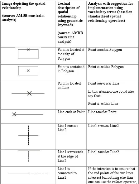
Table 1 – Spatial relationships as identified by the AMDB constraint analysis, and their implementation using standardized operators
Image depicting the spatial relationship
Analysis with suggestion for implementation using vocabulary terms (based on standardized spatial
relationship operators)
Point is located at the edge of
In this situation one could also say that:
Point is-within Line Line ends at Point Line touches Point
Line1 crosses
18 Copyright © 2015 Open Geospatial Consortium
Image depicting the spatial relationship
Analysis with suggestion for implementation using vocabulary terms (based on standardized spatial
relationship operators)
checking that:
the boundary of Line1 shall intersect the boundary of Line2 but the interior of Line1 shall not intersect the interior of Line 2
Line1 overlaps Line2 and Line1 does not cross Line2
Line is contained
The depicted relationship would also be covered by the crosses operator:
Line crosses Polygon Line crosses
Polygon
Line crosses Polygon
Image depicting the spatial
Analysis with suggestion for implementation using vocabulary terms (based on standardized spatial
relationship operators)
intersect the closure of the Polygon
The depicted relationship can be represented with varying degrees of complexity (and detail).
We can start with: Line touches Polygon
In order to ensure that the intersection is not just a point, we can also check the
dimension by adding: and the dimension of the intersection between the interior of the Line and the closure of the Polygon is equal to 1
Furthermore, in order to ensure that the end points of the line are not on the border of the polygon, we can add:
20 Copyright © 2015 Open Geospatial Consortium
Image depicting the spatial relationship
Analysis with suggestion for implementation using vocabulary terms (based on standardized spatial
relationship operators)
We can see that, depending on the desired outcome of the relationship test, we need to use a combination of spatial
relationship operators. The relates operator would allow us to express a complex
relationship directly.
Again, the depicted relationship can be represented with varying degrees of complexity.
We can start with:
Polygon1 touches Polygon2
In order to ensure that the intersection is not just a point, we can also check the
dimension by adding: and the dimension of the
Image depicting the spatial
Analysis with suggestion for implementation using vocabulary terms (based on standardized spatial
relationship operators)
Polygon2 is equal to 1
The relates operator would allow us to express the intended complex relationship directly.
Conclusions & Recommendations
The spatial relationships identified by the AMDB constraint analysis can be implemented using the set of named spatial relationship operators standardized by ISO/OGC. In
addition, the “relates” operator can be useful to identify specific relationships.
We recommend that a geospatial vocabulary used in the Aviation community uses the spatial relationship operators standardized by OGC and ISO. This would support understanding of geometric constraints by experts within the wider geospatial community.
Nevertheless, if other names for spatial relationship operators have already been
established within the aviation community, it would be possible to use those names in an aviation specific vocabulary while still adopting the definition and meaning of the standardized names. However, this requires that no conflict of terms is created (for example, defining “intersects” differently).
22 Copyright © 2015 Open Geospatial Consortium
7 Guidance for SBVR Rule Development
7.1 Identify Schema Level that SBVR Rule is written for
For automated derivation of Schematron from an SBVR rule, it is important to know the schema level for which the SBVR rule has been written3. This can be the conceptual level
and the implementation level.
If a rule has been written for the conceptual schema level, avoid using concepts that are only available in the implementation schema.
For example:
XPath like notation for noun concept concatenation using “/” and qualified names (ns:element).
Specific axis notation that is built upon the XML structure like descendant-or-self (see 8.1.4 for further details).
The [SBVR Profile for AIXM] should clearly identify for which schema level a construct defined by the profile is applicable. For example, “is-descendant-of” and “has
descendant” should only be used for rules on the XML implementation schema level. An exception would be if such constructs were also clearly defined for the conceptual level. In general, we recommend writing business rules only for the conceptual level. This allows deriving rule information for different implementation schema, for example XML (in form of Schematron code) but also SQL (as SQL constraints). This would also avoid that the business expert that writes the rules needs to understand a specific
implementation. Last but not least, it is also better because a specific implementation technology may be replaced at some point in the future by another technology, which would require that rules are re-written.
7.2 Be aware of implications when writing rules involving (dynamic) AIXM feature types
Each AIXM feature is a dynamic feature. Conceptually, these features are represented by a set of time slices. The AIXM UML model does not explicitly show this. The abstract AIXMFeature class has a set of timeSlices. The model does not show that AIXM feature types such as AirportHeliport inherit from AIXMFeature. Rather, this relationship is implicit. Furthermore, according to the UML model the properties of actual AIXM feature types belong to the feature. However, conceptually speaking they are owned by the according time slice type (e.g. AirportHeliportTimeSlice, which can be found in the XML implementation schema but not in the conceptual schema). This has implications for how business rules should be written.
We use the following (made-up) rule as example:
Each AirportHeliport shall have assigned designator value.
NOTE: there is an implicit quantification of “at-least-one” for “assigned designator value” (see description of the SBVR grammar in 8.2.5.1); the rule therefore is actually: “Each AirportHeliport shall have at-least-one assigned designator value.”
Let us assume that the intention behind this rule is to ensure that throughout the lifetime of an AirportHeliport feature, it shall always have a ‘designator’ value that is not null. The designator value is stored within time slices owned by the AirportHeliport feature – both conceptually and in actual XML encoded data. According to the AIXM Temporality Model [AIXMTM] there are different interpretations for time slices: baseline, permdelta, tempdelta, and snapshot. Without going into too much detail here, we can say that the time slices represent the state of an AIXM feature throughout its lifetime. Changes to property values are tracked through time and stored in time slices. A temporary change, for example, is stored in a tempdelta. A permanent change can be stored in a baseline and a permdelta. Last but not least, a snapshot represents the state of a feature for a given point in time. Values for the ‘designator’ property will be stored in all baselines and snapshots, but likely not in all permdeltas and tempdeltas.
A key question when evaluating AIXM business rules on actual AIXM data is for which time slices a condition must be checked. The rule from the example does not specify this. Discussions within Testbed 11 revealed that AIXM business rules can be defined for all four or a subset of time slice interpretation types. It therefore is not possible to
automatically select a specific subset of time slices – for example just baselines and snapshots – to evaluate a business rule against.
In order to automatically derive Schematron from SBVR rules, a software tool must therefore be able to identify which time slice types need to be checked. This can be achieved in two ways:
The rule itself contains the selection of time slices, as required.
Metadata for a rule states which time slice interpretations are to be checked. The excel file that contains AIXM business rules has such metadata.
The solution chosen for Testbed 11 was to express the necessary time slice selection in the business rule itself, for the following reasons:
A business rule may require different sets of interpretations for different
conditions, which cannot be expressed using a single field in an excel spreadsheet.
24 Copyright © 2015 Open Geospatial Consortium
Table 2 – Different ways of selecting AIXM feature time slices in a business rule
Business rule Selected time slices
Each AirportHeliport.timeSlice with interpretation equal-to
(‘BASELINE’,’SNAPSHOT’) shall have at least one assigned designator value.
Here we have an explicit selection of time slices based upon their interpretation value. Each baseline and snapshot is checked to see if it has a designator value (not being null), while tempdeltas and permdeltas are ignored.
Each AirportHeliport.timeSlice shall have at least one assigned designator value.
This can be problematic, because each and every time slice – thus also a tempdelta – must have a designator value (not being null); otherwise the translated rule will evaluate to false.
If the AIXM data to be checked with Schematron rules only contained baselines and snapshots then this should not be a problem. The validation of AIXM data and the way that AIXM business rule must be written in order to achieve correct results can thus be influenced by the
preprocessing (in this case: selection) performed on the input data.
Each AirportHeliport shall have at least one assigned designator value.
The tool recognizes that AirportHeliport is an AIXM feature type and therefore adds the “timeSlice” property as a segment before all calls to properties of that feature. The rule thus will become: Each
AirportHeliport shall have at least one assigned timeSlice.designator value.
This can be problematic, because if just one time slice – for example a tempdelta – exists that had a designator value (not being null), the translated rule will evaluate to true. The result would also be true if just one out of the possibly many baselines belonging to the feature had a designator value.
Business rule Selected time slices
problem. So again, the validation depends on the input data.
Conclusions & Recommendations
We can conclude that the way an AIXM business rule takes time slices into account can have an impact on the validation result and that the validation result can be influenced through a selection of the input data.
We recommend that AIXM business rules be written with explicit selection of time slices. This should be done whenever the rule states a condition that must be fulfilled for an AIXM feature property.
26 Copyright © 2015 Open Geospatial Consortium
8 Automated Derivation of SBVR Business Rules to Schematron Rules
8.1 Analysis of AIXM SBVR Rules and SBVR Profile for AIXM
NOTE: for simplicity reasons the rules presented in this section do not take time slice selection into account. For a detailed description of that topic, see section 7.2.
8.1.1 Assignment / Existence Checks
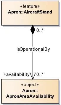
Example
AIXM-5.1_RULE-1A8519: It is obligatory that each AircraftStand with assigned availability value isOperationalBy exactly one ApronAreaAvailability
Analysis
In the context of AircraftStand, noun “availability” and verb “isOperationalBy” refer to the same property value, which is of type ApronAreaAvailability.
Figure 1 – Assignment check example – AircraftStand and ApronAreaAvailability in context
In this example, the cardinality of availability is 0..*. In other cases, it can be 0..1. The “assigned” keyword is an existential quantification. The SBVR profile adds to say that “… the referent thing is not null”. The use of “assigned” boils down to a null / existence check. It is a shortcut for the existential quantifier which, according to the SBVR profile, can be expressed with “at least one”.
“assigned” is part of a predicate that is (potentially part of) a filter on a set of values. In the example, this set is the set of all AircraftStand objects. In other words, the rule targets only those AircraftStand objects that have at least one availability value that is not null.
«feature»
Apron::AircraftStand
«object»
Apron:: ApronAreaAv ailability
0..*
isOperationalBy
This essentially constitutes a selection of AircraftStand objects. The expression “isOperationalBy exactly one ApronAreaAvailability” contains a quantification that targets the same property as the assignment used in the selection: availability (because “isOperationalBy” is the name of the association where availability is the role that represents a property of AircraftStand).
An existential quantification checks that a certain number of elements of a given set4
exist. For an element to exist, it must not be null. A quantification of a variable X therefore implies an assignment check for that variable.
In summary, the rule can be simplified to: it is obligatory that each AircraftStand isOperationalBy at most one ApronAreaAvailability
If the rule was intended to ensure that exactly one availability exists for each AircraftStand, it could be written as follows:
It is obligatory that each AircraftStand isOperationalBy exactly one ApronAreaAvailability or
Each AircraftStand shall have exactly one availability.
8.1.2 Handling of Choices
Example
AIXM-5.1_RULE-1A853D: It is obligatory that each ChangeOverPoint with assigned airportReferencePoint value isLocatedAt exactly one AirportHeliport
Analysis
The conceptual model of a ChangeOverPoint has an optional “location” property of type “SignificantPoint” (see Figure 2).
28 Copyright © 2015 Open Geospatial Consortium
Figure 2 – ChangeOverPoint and <<choice>> SignificantPoint with its options
The location.SignificantPoint has not been included in the SBVR rule because SignificantPoint is a “choice” class and at first it was decided to consider them “transparent”.
Using the association name as verb that identifies the choice and then the name of the class that represents the desired choice works if all choices have different types. However, this is not true in general. Consider the following figure.
Figure 3 – Construction of a <<choice>>, equivalent to a <<union>> as defined in the ISO 19100 series of standards
It is perfectly valid to have two choices of the same type, because the semantics of each choice would be different.
The rule “It is obligatory that each Class1 verb exactly one Class4” would be ambiguous, because it is not clear whether choiceB or choiceC is allowed.
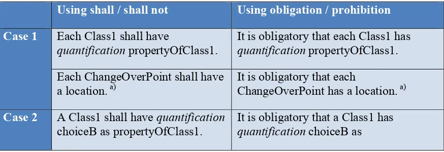
Thus, it is better to be explicit when formulating a rule that involves a <<choice>> type. Three cases need to be considered:
1. The <<choice>> itself shall be identified – for example for a general existence check.
2. One of the available choices shall be identified.
3. Two or more of the available choices shall be identified. Rules for the different cases can be formulated as shown in Table 3.
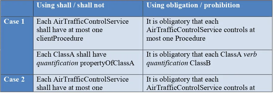
Table 3 – The various cases of formulating a rule that includes a <<choice>>
Using shall / shall not Using obligation / prohibition
Case 1 Each Class1 shall have
quantification propertyOfClass1.
It is obligatory that each Class1 has quantification propertyOfClass1.
Each ChangeOverPoint shall have a location. a)
It is obligatory that each
ChangeOverPoint has a location. a)
Case 2 A Class1 shall have quantification It is obligatory that a Class1 has
30 Copyright © 2015 Open Geospatial Consortium
propertyOfClass1. A ChangeOverPoint shall have an
airportReferencePoint as location.
It is obligatory that a ChangeOverPoint has an airportReferencePoint as location.
Case 3 A Class1 shall have quantification
choiceA or choiceB or choiceC as propertyOfClass1.b)
It is obligatory that a Class1 has quantification choiceA or choiceB or choiceC as propertyOfClass1.b)
a) The cardinality in the example (Figure 2) would theoretically allow a SignificantPoint (rather: a non-abstract subtype of SignificantPoint) without any actual choice value, because the choices themselves are optional. However, the <<choice>> class does not appear in the AIXM XML encoding. Instead, the name of an XML element that
represents a choice is a concatenation of the role name of the <<choice>> class with the role name of the target class of each choice branch, separated by “_” (see
[AIXMUML2XSD] for further details).
The UML to GML application schema encoding rules for <<union>> classes prevent this mismatch between conceptual and implementation schema. There, the properties of a <<union>> always have cardinality 1.
b) The choices must be concatenated with ‘or’.
We suggest the introduction of the construct “choice1 or … or choiceN as” to identify the choice or choices of interest. This appears to result in a suitable formulation of the rule. 8.1.3 Handling Inheritance
Example
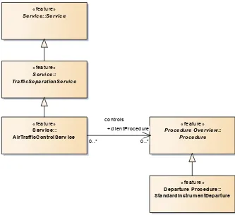
AIXM-5.1_RULE-BB801: It is obligatory that each Service
specialization TrafficSeparationService specialization AirTrafficControlService with assigned clientProcedure value controls exactly one Procedure specialization StandardInstrumentDeparture
Analysis
According to the SBVR profile for AIXM, “specialisation” is an additional categorisation fact-type used to target a specific non-abstract subclass in an inheritance hierarchy. In this case, the rule shall ensure that an AirTrafficControlService has at most one5
clientProcedure of type StandardInstrumentDeparture.
Figure 4 – Inheritance example – AirTrafficControlService and Procedure in context
Documenting all parents of the rule relevant classes is unnecessary and overly complicates the SBVR rule. The inheritance information is already contained in the conceptual schema from which it can be retrieved by the automation tool. The rule can therefore be simplified to:
“It is obligatory that each AirTrafficControlService controls at most one StandardInstrumentDeparture”
The context class – AirTrafficControlService – is clearly identified by the rule. The value type of property “clientProcedure” is the abstract type “Procedure”. It has multiple subtypes, StandardInstrumentDeparture being one of them. The tool can determine that StandardInstrumentDeparture is a valid substitution for Procedure. This should be sufficient information to derive schematron rules.
When it gets to inheritance, we need to consider two cases:
1. The set of classes composed of a given type and all its subtypes shall be identified.
«feature»
Service::Service
«feature»
Service:: TrafficSeparationService
«feature» Serv ice:: AirTrafficControlServ ice
«feature»
Procedure Overview:: Procedure
«feature» Departure Procedure:: StandardInstrumentDeparture 0..*
controls
+clientProcedure
32 Copyright © 2015 Open Geospatial Consortium
Rules for the different cases can be formulated as shown in Table 4. The rule
formulations in the table not only cover the specific AIXM SBVR rule used as example so far. They also cover a more general example, which is shown in the following figure.
Figure 5 – General case of an inheritance relationship
As we can see, both ClassA and ClassB have a set of subtypes. Keep in mind that any subtype can be used to represent its supertype, following the semantics of inheritance defined by UML. It therefore is not necessary - and in fact would even be wrong – to exclude a specific subtype in a rule when its supertype would be included (for example, excluding SubtypeB1 or SubtypeB11 when ClassB was included). We can therefore focus on rule formulations that allow us to identify those classes we are really interested in. All subtypes of these classes should automatically be identified as well.
Table 4 – The different cases of formulating a rule to identify classes in an inheritance hierarchy
Using shall / shall not Using obligation / prohibition
Case 1 Each AirTrafficControlService
shall have at most one clientProcedure
It is obligatory that each
AirTrafficControlService controls at most one Procedure
Each ClassA shall have
quantification propertyOfClassA
It is obligatory that each ClassA verb quantification ClassB
Case 2 Each AirTrafficControlService
shall have at most one
It is obligatory that each
clientProcedure of type StandardInstrumentDeparture
most one StandardInstrumentDeparture
Each ClassA shall have
quantification propertyOfClassA of type SubtypeB11 or SubtypeB2
It is obligatory that each ClassA verb quantification SubtypeB11 or SubtypeB2
Note that when using “shall” and “shall not” the keyword “of type” is introduced to support a more natural formulation of the rule. This is not necessary when obligation and prohibition is used as modality.
This approach allows rules to be expressed against abstract types, removing the need to create rules for each subtype if only properties of the supertype are rule relevant. Likewise, it would remove the need to list all possible subtypes in the rule. An example for this is:
34 Copyright © 2015 Open Geospatial Consortium
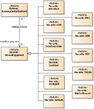
Figure 6 - Inheritance example (2) – RunwayCentrelinePoint and NavaidEquipment in context
When deriving Schematron rules the tool should automatically take inheritance into account. The schema-element() XPath 2.0 function would be very useful to identify a type and all possible subtypes. However, schema aware XPath processing may not always be available in Schematron processors. As a fallback, the tool uses the names of all subtypes found in the model. The drawback of that approach is that any potential extension that is not contained in the model and that added further subtypes will not be recognized by the Schematron rules generated by the tool.
8.1.4 Expressions for XPath Axis Names
Example
Analysis
The keywords “has/have descendant” and “is-descendant-of” are introduced by the SBVR Profile for AIXM as additional fact-types/verbs. They heavily relate to the descendant-or-self axis notation in XPath expressions.
Use of these verbs is suitable when the XML implementation is the schema level that an SBVR rule targets (see 7.1). If the schema level is the conceptual level, i.e. rules are written for the UML model, the “descendant” verbs are not appropriate because the structure of a UML model is different compared to an XML document. The relationships between elements in the UML model are not only parent-child relationships. There can be reflexive associations and cyclic relationships which are not covered by XPath axes. Apparently, the rule in the example has been written for the XML implementation schema. It uses “Curve” and “ArcStringByBulge” instead of “GM_Curve” and
"GM_ArcStringByBulge" which are contained in the conceptual model of ISO 19107. If the rule was written for the conceptual schema, it should read: “Each GM_Curve shall not have a segment of type GM_ArcStringByBulge.” Derivation of Schematron for this rule would require additional knowledge about the specific implementation of ISO 19107 in XML. Testbed 11 focused on rules for a given application schema – AIXM – which has well-defined encoding rules to derive XML Schema from the conceptual model. Support for rules written for external models, especially with a very specific XML implementation, is therefore a future work item.
8.1.5 Regular Expressions
Example
AIXM-5.1_RULE-1A4A7A: Each AerialRefuellingAnchor with refuellingBaseLevel.uom equal-to ('FL', 'SM') shall have refuellingBaseLevel value expressed with 1, 2 or 3 digits
Analysis
It is very hard for a tool to recognize conditions like “value expressed with 1, 2 or 3 digits”. Whenever the textual representation of a property value must comply with a specific structure, regular expressions could be used. They provide a rich feature set to control text structure.
Using a regular expression, the rule from the example can be formulated as follows: Each AerialRefuellingAnchor with refuellingBaseLevel.uom equal-to ('FL', 'SM') shall have refuellingBaseLevel matching ‘\d{0,3}’.
36 Copyright © 2015 Open Geospatial Consortium
familiar with regular expressions write the expression for him. The benefit would be that the tool is then able to automatically derive Schematron code from the rule.
XPath 1.0 does not support regular expression matching. Its successor, XPath 2.0, provides such functionality. By default, Schematron uses the XPath language as used in XSLT 1.0 – which is XPath 1.0. Modern tools also support XSLT 2.0 and thus XPath 2.0 for Schematron validation. At this point it is not clear whether the regular expression support offered by XPath 2.0 is sufficient or not. If not, a new function could be introduced that realizes regular expressions as required6. This would have the added
benefit that the function can be defined for both XPath 1.0 and 2.0. The cost would be that it requires an extension of the Schematron processor.
8.1.6 Inclusion of External Vocabularies
Example
AIXM-5.1_RULE-29FE0: A Note shall not (be-descendant-of FeatureTimeslice with assigned descendant event:theEvent value) and have assigned translatedNote.note value using a different character set from
{'A','B','C','D','E','F','G','H','I','J','K','L','M','N','O','P','Q','R','S','T','U','V','W','X','Y','Z', 'a','b','c','d','e','f','g','h','i','j','k','l','m','n','o','p','q','r','s','t','u','v','w','x','y','z','0','1','2','3','4','5 ','6','7','8','9','-','?',':','(',')','.',',',"'",'=','/','+'}
Analysis
The presence of “be-descendant-of” indicates that this rule is targeting the XML implementation schema, rather than the conceptual schema (see 8.1.4). The rule would also be a candidate for using a regular expression (see 8.1.5). Of primary interest in this section, however, is the presence of “event:theEvent” in the rule.
"theEvent" is a property introduced by the Digital NOTAM Event Specification (DNES). The construct “event:theEvent” very likely represents a qualified name. In the XML encoding qualified names uniquely identify the namespace to which an element belongs. In this case “event” hints at the namespace assigned to the DNES, because “event” is often used as the XML namespace abbreviation for elements of this schema.
The conceptual schema of the DNES is not included in the core AIXM UML model. The DNES is an AIXM application schema that is an extension of the AIXM 5.1 model. As such, it is not part of the AIXM vocabulary represented by the core conceptual schema of AIXM. According to [1] there are different ways to include a term (noun or verb) from an external vocabulary in SBVR rules written against a given vocabulary (in our case: AIXM):
6 Such an approach has been taken before, for regular expression matching in OCL expressions (for further details, see
Adopt the term and its definition
Quote the term
Include the external vocabulary
Suffice to say that in the context of writing SBVR rules with a conceptual schema providing most of the vocabulary7 these approaches essentially represent a schema
import. Qualification of a term is only needed in case that the (rule) context of the term does not uniquely identify the vocabulary that the term belongs to. For the example, this means that “theEvent” can be used without using “event:” as qualifier, because the core AIXM schema does not contain a property or association named “theEvent”.
Qualification can be achieved in different ways:
Using qualified names as in XML – example: event:theEvent
Using a UML style – example: {DNES application schema name}::theEvent
Using a namespace identifier (often used in [1]) – example: theEvent [DNES namespace]
The latter may be easier to read and write for someone who is not familiar with XML. In order for a tool to recognize terms that belong to an external schema, the tool must know that schema. In order to recognize DNES terms, the tool would therefore need to know all classes that belong to the conceptual schema of DNES, their inheritance relationships, their attributes and associations, as well as any schemas that DNES
imports. The best way to achieve this is to provide a consolidated UML model to the tool, with all these details readily available. The consolidated model would include the core AIXM schema as well as the DNES schema plus any imported schema.
8.1.7 SRS Name
Example
AIXM-5.1_RULE-3E8: Each assigned srsName value shall be equal-to 'urn:ogc:def:crs:EPSG::4326'
Analysis
“srsName” is not part of the conceptual model of ISO 19107. Apparently the SBVR rule is written for the XML implementation schema of AIXM, not its conceptual schema. It makes sense to do so because this covers all cases where an SRS name can occur with just a single rule.
Note that this rule creates a bit of tension, because (OGC 12-028r1) implies that – at least theoretically – EPSG::3395 could be used to express a rhumbline where the latitudes of two consecutive points of a curve segment are different.
38 Copyright © 2015 Open Geospatial Consortium
8.2 Schematron Derivation
8.2.1 Overview
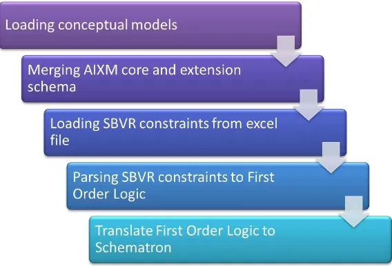
The process of deriving Schematron code from business rules expressed in SBVR consists of five steps (Figure 7) which are described in detail in the following sections.
Figure 7 – Schematron derivation process
The functions required for the execution of each step are implemented by ShapeChange8,
an open source tool that converts application schemas in UML to GML application schemas, Schematron schemas, JSON schemas and many other representations. 8.2.2 Loading the Conceptual Models
The conceptual schema of AIXM 5.1 was made available via a Sparx Systems Enterprise Architect Project (.eap) file. Within Testbed 11, the conceptual schema for the Digital NOTAM Event Specification has been added to the model as well.
Figure 8 – package structure of AIXM, including the core conceptual schema and extensions
Loading the model from the .eap file is achieved using readily available ShapeChange functionality. Only the packages “AIXM” and “Digital NOTAM Event Specification” (see Figure 8) are loaded as application schema.
While loading the schema contents, stereotypes used in AIXM are mapped to stereotypes that are well-known by ShapeChange. Well-known stereotypes for the purposes of ShapeChange are those defined in the UML specification, and in the ISO 19100-series of specifications, specifically ISO/TS 19103:2005, ISO 19109:2005 and GML 3.2/ISO 19136:2007. Table 5 documents the stereotype mapping applied in Testbed 11.
Table 5 – Mapping of AIXM stereotypes to well-known stereotypes
Stereotype used in AIXM model Well-known Stereotype
object, message <none> (an empty stereotype identifies an object type)
choice union
feature featureType
40 Copyright © 2015 Open Geospatial Consortium
8.2.3 AIXM Model (Core and Extensions) Merging
AIXM has a specific way of adding information to core schema classes that is different to how it is usually done in UML and in ISO application schema. Where usually
information is added through subtyping, AIXM has the concept of extensions. An extension schema is a schema that:
Can define <<extension>> classes that extend: o either a specific feature or object type o or all feature types9
Can define <<codelist>> classes that extend code lists from the core schema
Can define new code lists as well as feature and object types
The objective of this approach is described in [AIXMASGEN] section 1.3 as follows: “The core AIXM model provides the definition of standardised aeronautical
information features. In order to use AIXM for a specific application, a Community of Interest (COI) will have to agree upon how instances of AIXM features are to be exchanged and communicated in the community. […]
In the definition of the AIXM Application Schema, the COI might also want to extend the core AIXM with additional properties and features. Some principles that regulate such extensions include:
An extension of an existing AIXM feature should remain valid against the definition of the core AIXM XSD element with the same name (for that purpose, the
AbstractSomeFeatureExtension element is provided in the core AIXM XSD). A consequence is that it is not possible to extend <<datatype>> classes. Only <<codelist>> may be extended.
An additional feature and objects shall follow the core AIXM modelling conventions (stereotypes, naming, data types, etc.)”
A consequence of this approach is that actual AIXM data can contain information that is specified by multiple extensions, and that an AIXM processor is able to ignore unknown extensions to core AIXM features.
With the AIXM extension mechanism, AIXM feature and object types conceptually own all the properties that are added to them via <<extension>> types. This is useful for writing business rules, because it allows rules like the following:
Each RunwayDirection.timeSlice that belongsTo Event with scenario equal-to
'RWY.CLS' and with version equal-to '2.0' shall have exactly one assigned availability
9 An example for such an extension is the “AnyAIXMFeature” type defined in the Digital NOTAM Event
value and shall have availability.ManoeuvringAreaAvailability.operationalStatus equal-to 'CLOSED'.
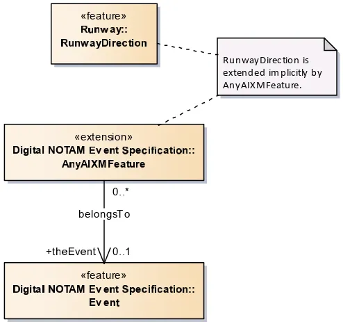
“belongsTo” is the name of an association that is added via the Digital NOTAM Event Specification to all AIXM feature types (see Figure 9).
Figure 9 - AIXM extension mechanism - RunwayDirection belongsTo Event
In order to parse AIXM business rules and generate Schematron code with correct XPath expressions, ShapeChange checks that the noun and verb concepts declared in business rules are compliant to the conceptual model of AIXM. This means that a business rule can only make statements about properties of an AIXM feature if the feature actually has these properties.
The rule chosen as example in this section makes use of the property “theEvent” via the verb “belongsTo” that refers to “Event”. The property is defined in the DNES extension schema and accessed as if it belonged to the feature type RunwayDirection. According to the conceptual model shown in Figure 9 RunwayDirection does not have this property. ShapeChange would therefore report an error while parsing the business rule10 – unless
the AIXM schemas are merged on-the-fly.
10 The reason is that there is no explicit inheritance relationship between RunwayDirection and the extension class. The
AIXM extension mechanism appears to prefer extensions of specific feature and object types through explicit «extension»
Digital NOTAM v e t pe at ::
A AIXMFeature
«feature»
igita OTAM v e t pe at :: Ev e
«feature» ay:: ay ire ti
RunwayDirection is extended implicitly by AnyAIXMFeature.
0..*
belongsTo