Date:2012-01-25
Reference number of this document:OGC 11-072r2
Category:OGC® Public Engineering Report
Editors:Wenny Rahayu, Torab Torabi, Andrew Taylor-Harris, and Florian Puersch
OGC
®OWS-8 Aviation – Weather Information Exchange
Model (WXXM) Engineering Report
Copyright © 2012 Open Geospatial Consortium
To obtain additional rights of use, visit http://www.opengeospatial.org/legal/.
Warning
This document is not an OGC Standard. This document is an OGC Public
Engineering Report created as a deliverable in an OGC Interoperability Initiative and is not an official position of the OGC membership. It is distributed for review and comment. It is subject to change without notice and may not be referred to as an OGC Standard. Further, any OGC Engineering Report should not be referenced
as required or mandatory technology in procurements.
Document type: OpenGIS® Engineering Report Document subtype: NA
Preface
This document is a deliverable for the OGC Web Services 8 (OWS-8) testbed activity. OWS testbeds are part of OGC's Interoperability Program, a global, hands-on and collaborative prototyping program designed to rapidly develop, test and deliver proven candidate standards or revisions to existing standards into OGC's Standards Program, where they are formalized for public release. In OGC's Interoperability Initiatives,
international teams of technology providers work together to solve specific geoprocessing interoperability problems posed by the Initiative's sponsoring organizations. OGC
Interoperability Initiatives include test beds, pilot projects, interoperability experiments and interoperability support services - all designed to encourage rapid development, testing, validation and adoption of OGC standards.
The OWS-8 sponsors are organizations seeking open standards for their interoperability requirements. After analyzing their requirements, the OGC Interoperability Team
recommend to the sponsors that the content of the OWS-8 initiative be organized around the following threads:
* Observation Fusion
* Geosynchronization (Gsync)
* Cross-Community Interoperability (CCI) * Aviation
More information about the OWS-8 testbed can be found at:
http://www.opengeospatial.org/standards/requests/74
OGC Document [11-139] “OWS-8 Summary Report” provides a summary of the OWS-8 testbed and is available for download:
License Agreement
Permission is hereby granted by the Open Geospatial Consortium, Inc. ("Licensor"), free of charge and subject to the terms set forth below, to any person obtaining a copy of this Intellectual Property and any associated documentation, to deal in the Intellectual Property without restriction (except as set forth below), including without limitation the rights to implement, use, copy, modify, merge, publish, distribute, and/or sublicense copies of the Intellectual Property, and to permit persons to whom the Intellectual Property is furnished to do so, provided that all copyright notices on the intellectual property are retained intact and that each person to whom the Intellectual Property is furnished agrees to the terms of this Agreement.
If you modify the Intellectual Property, all copies of the modified Intellectual Property must include, in addition to the above copyright notice, a notice that the Intellectual Property includes modifications that have not been approved or adopted by LICENSOR.
THIS LICENSE IS A COPYRIGHT LICENSE ONLY, AND DOES NOT CONVEY ANY RIGHTS UNDER ANY PATENTS THAT MAY BE IN FORCE ANYWHERE IN THE WORLD.
THE INTELLECTUAL PROPERTY IS PROVIDED "AS IS", WITHOUT WARRANTY OF ANY KIND, EXPRESS OR IMPLIED, INCLUDING BUT NOT LIMITED TO THE WARRANTIES OF MERCHANTABILITY, FITNESS FOR A PARTICULAR PURPOSE, AND NONINFRINGEMENT OF THIRD PARTY RIGHTS. THE COPYRIGHT HOLDER OR HOLDERS INCLUDED IN THIS NOTICE DO NOT WARRANT THAT THE FUNCTIONS CONTAINED IN THE INTELLECTUAL PROPERTY WILL MEET YOUR REQUIREMENTS OR THAT THE OPERATION OF THE INTELLECTUAL PROPERTY WILL BE
UNINTERRUPTED OR ERROR FREE. ANY USE OF THE INTELLECTUAL PROPERTY SHALL BE MADE ENTIRELY AT THE USER’S OWN RISK. IN NO EVENT SHALL THE COPYRIGHT HOLDER OR ANY CONTRIBUTOR OF
INTELLECTUAL PROPERTY RIGHTS TO THE INTELLECTUAL PROPERTY BE LIABLE FOR ANY CLAIM, OR ANY DIRECT, SPECIAL, INDIRECT OR CONSEQUENTIAL DAMAGES, OR ANY DAMAGES WHATSOEVER RESULTING FROM ANY ALLEGED INFRINGEMENT OR ANY LOSS OF USE, DATA OR PROFITS, WHETHER IN AN ACTION OF CONTRACT, NEGLIGENCE OR UNDER ANY OTHER LEGAL THEORY, ARISING OUT OF OR IN CONNECTION WITH THE IMPLEMENTATION, USE, COMMERCIALIZATION OR PERFORMANCE OF THIS INTELLECTUAL PROPERTY.
This license is effective until terminated. You may terminate it at any time by destroying the Intellectual Property together with all copies in any form. The license will also terminate if you fail to comply with any term or condition of this Agreement. Except as provided in the following sentence, no such termination of this license shall require the termination of any third party end-user sublicense to the Intellectual Property which is in force as of the date of notice of such termination. In addition, should the Intellectual Property, or the operation of the Intellectual Property, infringe, or in LICENSOR’s sole opinion be likely to infringe, any patent, copyright, trademark or other right of a third party, you agree that LICENSOR, in its sole discretion, may terminate this license without any compensation or liability to you, your licensees or any other party. You agree upon termination of any kind to destroy or cause to be destroyed the Intellectual Property together with all copies in any form, whether held by you or by any third party.
Except as contained in this notice, the name of LICENSOR or of any other holder of a copyright in all or part of the Intellectual Property shall not be used in advertising or otherwise to promote the sale, use or other dealings in this Intellectual Property without prior written authorization of LICENSOR or such copyright holder. LICENSOR is and shall at all times be the sole entity that may authorize you or any third party to use certification marks, trademarks or other special designations to indicate compliance with any LICENSOR standards or specifications.
This Agreement is governed by the laws of the Commonwealth of Massachusetts. The application to this Agreement of the United Nations Convention on Contracts for the International Sale of Goods is hereby expressly excluded. In the event any provision of this Agreement shall be deemed unenforceable, void or invalid, such provision shall be modified so as to make it valid and enforceable, and as so modified the entire Agreement shall remain in full force and effect. No decision, action or inaction by LICENSOR shall be construed to be a waiver of any rights or remedies available to it.
Contents
Page1 Introduction ... 1
1.1 Scope ... 1
1.2 Document contributor contact points ... 1
1.3 Revision history ... 2
5 WXXM Assessmentoverview ... 5
5.1 Overview ... 5
5.2 WXXM data in OWS-8 ... 6
5.2.1 Data from CSISS,GMU ... 6
5.2.2 Data from NCAR (contact: Aaron Braeckel) ... 7
6 WXXM 1.1.1 Architectural Overview ... 7
6.1 WXXM Audit ... 7
6.1.1 Overview ... 7
6.1.2 Design Considerations ... 9
6.1.3 Deployment ... 9
6.1.3.1 Design Considerations ... 9
6.1.3.2 Deployment Issues and Recommendations ... 11
6.1.4 Issues and Recommendations ... 11
6.1.4.1 Overview ... 11
6.1.4.2 Specific Rules in Naming GML Schema objects ... 11
6.1.4.3 General Issues ... 12
6.1.4.4 Generic Weather Domain Issues ... 12
6.1.4.5 Aviation Domain Issues ... 16
6.1.5 WXXM Coverage Representation ... 18
6.1.5.1 Introduction ... 18
6.1.5.2 Comparison with OGC coverage model, GMLCOV ... 20
6.1.5.3 Recommendation ... 22
6.2 Unit of Measure (UOM) ... 23
6.2.1 Overview ... 23
6.2.1.1 Encoding Allignment ... 23
6.2.1.3 Interoperability ... 25
6.2.2 Architectural Design Options for Distributed UOM ... 26
6.2.2.1 Centralized Architecture ... 26
6.2.2.2 De-Centralized Architecture ... 27
6.2.2.3 Local Copy Architecture ... 29
6.2.2.4 Local Transformation Architecture ... 31
6.2.3 Deployment ... 32
6.2.3.1 Separation of semantic and physical layers ... 32
6.2.3.2 Data & Schema ... 33
6.2.3.3 Transformation ... 34
6.2.3.4 Profiles ... 36
6.2.3.5 Implementation ... 36
6.2.4 Issues and recommendations ... 40
6.2.4.1 Comparison ... 40
6.2.4.2 Performance: what is desired, what is to be expected? ... 41
6.2.4.3 Local versus remote access ... 42
6.2.4.4 Version Management ... 42
6.2.4.5 Open vs. Secure ... 42
6.3 Coordinate Reference System (CRS) ... 43
6.3.1 Overview ... 43
6.3.2 Design Considerations ... 44
6.3.3 Deployment ... 44
6.3.4 Issues and Recommendations ... 45
6.4 Web Coverage Services (WCS) ... 45
6.4.1 Overview ... 46
6.4.2 Operations ... 46
6.4.2.1 GetCapabilities ... 47
6.4.2.2 DescribeCoverage ... 47
6.4.2.3 GetCoverage 2D ... 47
6.4.2.4 GetCoverage 3D ... 47
6.4.3 CSISS-GMU Deployment ... 48
6.4.3.1 WCS deployed operations ... 48
6.4.3.2 GetCapabilities ... 48
6.4.3.3 DescribeCoverage ... 49
6.4.3.4 GetCoverage ... 49
6.4.4 Issues and Recommendation ... 49
6.4.5 Jacobs University | rasdaman GmbH WCS & WCPS & WPS Deployment ... 50
6.4.5.1 By Scenario ... 50
6.4.5.2 By Dataset ... 51
Figures
Figure 1: WXXM Model Layers ... 6
Figure 2: WXXM Weather Data Model ... 8
Figure 3 Mapping Process ... 11
Figure 4 Weather Domain Schema Dependencies ... 15
Figure 5: WXXM Schema Dependencies ... 17
Figure 6: The WXXM Coverage structure ... 19
Figure 7: The WXXM coverage hierarchy ... 19
Figure 8: The GMLCOV Coverage structure ... 21
Figure 9: Centralized Architecture ... 26
Figure 10: Centralized Initialization ... 27
Figure 11: Centralized Sequence ... 27
Figure 12: De-Centralized Architecture ... 28
Figure 13: De-Centralized Initialization ... 28
Figure 14: De-Centralized Sequence ... 29
Figure 15: Local Copy Architecture ... 29
Figure 16: Local Copy Initialization ... 30
Figure 17: Local Copy Sequence ... 30
Figure 18: Local Transformation Architecture ... 31
Figure 19: Local Transformation Initialization ... 31
Figure 20: Local Transformation Sequence ... 32
Figure 21: Greater picture architecture ... 33
Figure 22: UOM in the Schema ... 34
Figure 23: UOM Transformation step by step ... 36
Figure 24: UOM Profiles ... 36
Figure 25: Process implementation ... 37
Figure 26: Web Implementation ... 40
Table 2: Redundant Imports and Includes ... 13
Table 3: AVWX Domain GML Naming Non Conformance ... 16
Table 4: WXXM vs. GMLCOV coverage types ... 20
OGC
®OWS-8 Aviation – WXXM Engineering Report
1 Introduction
1.1 Scope
This OGC™ document specifies the advancement of WXXM and Weather Concepts in the OWS-8 Aviation Thread. The focus is on investigating and demonstrating the applicability and suitability of WXXM in producing accurate, real-time aircraft weather radar data using OGC™ Web Coverage Services (WCS) to be used by meteorological applications and services supporting aviation. Such applications provide information which enhances safe and efficient tactical and pre-tactical decision making during planning and execution of a flight.
Attention is drawn to the possibility that some of the elements of this document may be the subject of patent rights. The Open Geospatial Consortium Inc. shall not be held responsible for identifying any or all such patent rights.
Recipients of this document are requested to submit, with their comments, notification of any relevant patent claims or other intellectual property rights of which they may be aware that might be infringed by any implementation of the standard set forth in this document, and to provide supporting documentation.
1.2 Document contributor contact points
All questions regarding this document should be directed to the editor or the contributors:
Name Organization
Wenny Rahayu (Editor) La Trobe University
Torab Torabi (Editor) La Trobe University
Florian Puersch La Trobe University
Andrew Taylor-Harris Airservices Australia
Peter Baumann Jacobs University Bremen, Rasdaman GmbH
David Burggraf Galdos
Richard Martell Galdos
Russ Gillespie Northrop Grumman Corporation
1.3 Revision history
Date Release Editor Primary clauses modified
Description
2011-05-04 0.1.0 WR TT All Definition of initial document outline
2011-06-23 0.2.0
OGC 11-072
All All Combination of all subclauses of clause 6
2011-08-26 0.3.0
OGC 11-072r1
AT FP 6.1, 6.2 Update to reflect input from other participants as well as own development
2011-09-30 1.0
OGC 11-072r2
All 6 Update to reflect input from other participants as well as own development and implementation
1.4 Future work
This document version is subject to formal review. Therefore, it is envisaged that it will be modified later when all contributions are collated.
1.5 Forward
Attention is drawn to the possibility that some of the elements of this document may be the subject of patent rights. The Open Geospatial Consortium Inc. shall not be held responsible for identifying any or all such patent rights.
Recipients of this document are requested to submit, with their comments, notification of any relevant patent claims or other intellectual property rights of which they may be aware that might be infringed by any implementation of the standard set forth in this document, and to provide supporting documentation.
2 References
The following documents are referenced in this document. For dated references, subsequent amendments to, or revisions of, any of these publications do not apply. For undated references, the latest edition of the normative document referred to applies. ISO 19115 (all parts), Geographic information – Metadata
ISO 19139, Geographic information - Metadata - XML schema implementation
ISO 19136:2007, Geographic information — Geography Markup Language (GML)
ISO/DIS 19142, Geographic information — Web Feature Service
ISO/DIS 19143, Geographic information – Filter Encoding
ISO/DIS 19156, Geographic information – Observations and Measurements
OGC 09-110r3, OGC® WCS (Web Coverage Service) 2.0 Interface Standard - Core
OGC 06-121r3, OGC® Web Service Common Standard
OGC 09-032, OpenGIS® OWS-6-SWE Event Architecture Engineering Report
OGC 09-050r1, OpenGIS® OWS-6-AIM Engineering Report
OGC 10-079, OWS-7 Aviation Architecture Engineering Report
OGC 10-131, OWS-7 Aviation AIXM Assessment Report
OGC 10-146r1. OGC® GML 3.2.1 Application Schema for Coverages, version 1.0.0 FAA/EATM. WXXM 1.1 Primer, draft version
Encoding Representative Weather Datasets
https://portal.opengeospatial.org/twiki/pub/OWS8/AviationWeather/WXXS-Compliance.doc
3 Terms and definitions
For the purposes of this report, the terms and definitions are defined in the OWS-6 Event Architecture Engineering Report 032) and the OWS-6 AIM Engineering Report (09-050r1).
4 Conventions
4.1 Abbreviated terms
AIM Aeronautical information Management
AIXM Aeronautical Information Exchange Model
API Application Programming Interface
ER Engineering Report
FE Filter Encoding
FES Filter Encoding Specification
FIR Flight Information Region
FL Flight Level
FPS Feature Portrayal Service
GML Geography Markup Language
HTTP HyperText Transport Protocol
ICAO International Civil Aviation Organization
ISO International Standardization Organization
METAR Metorological Aviation Report
NNEW NextGen Network Enabled Weather
NOTAM Notice to Airmen
OGC Open Geospatial Consortium
OWS OGC Web Services
OWS-8 OWS Testbed phase 8
O&M Observation & Measurement
SIGMET Significant Meteorological Information
SLD Styled Layer Descriptor
SOA Service Oriented Architecture
SWE Sensor Web Enablement
UCAR University Corporation for Atmospheric Research
UDP User Datagram Protocol
UML Unified Modelling Language
UOM Unit of Measure
VA Volcanic Ash
WCS Web Coverage Service
WFS Web Feature Service
WFS-T Web Feature Service –Transactional
WMS Web Mapping Service
WXXM Weather Information Exchange Model
XML Extensible Markup Language
4.2 UML notation
Most diagrams that appear in this standard are presented using the Unified Modeling Language (UML) static structure diagram, as described in Subclause 5.2 of [OGC 06-121r3].
5 WXXM Assessment overview
5.1 Overview
WXXM, the Weather Data Model, is a UML-based structural definition for the exchange of weather information, featuring an Aviation-specific layer. It was designed by
EUROCONTROL, in partnership with NNEW.
WXXM is not a piece of software, nor does it have any function on its own. It defines a common vocabulary for exchanging weather information between organizations, but it does not inherently provide any sort of functionality to facilitate this exchange. It is, fundamentally, a set of guidelines for how to think about weather data.
The Weather Data Model is, in fact, a set of three-tiered data models, only one part of which is actually called WXXM: Weather Exchange Model. Together, the three models provide conceptual, structural, and physical representations of weather data:
The Weather Conceptual Model (WXCM) provides a high-level, implementation-independent look at how weather data concepts are connected.
The Weather Exchange Model (WXXM) provides a more logical and structural (if still implementation-independent) perspective of the same data, in more
complete detail — the interrelationships of every weather data concept are spelled out.
The Weather Exchange Schema (WXXS) is a machine-generated,
XML-formatted implementation of the Exchange Model — a "physical" code version of it.
As it has become a commonly used, "generic" term, WXXM will be used in the following sections of this document, irrespective of which part of the model is being referred to.
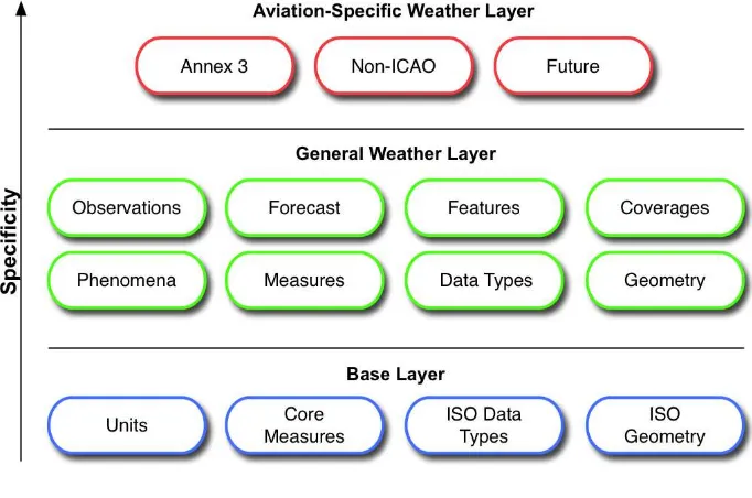
The different layers of the WXXM model are represented in Figure 1 below:
Figure 1: WXXM Model Layers
5.2 WXXM data in OWS-8
During OWS-8, the following data sets have been encoded which are relevant for WXXM:
5.2.1 Data from CSISS,GMU
NOAA GOES Inflight Icing product
NOAA GOES Clear Air Turbulence product
NOAA GOES Volcanic Ash product
NOAA GOES Wind product
NOAA GOES Aviation products shown in Google Earth (last updated April 04, 2011):
o KML example 1:
http://geobrain.laits.gmu.edu/ows8/kml/20110405wind/wind20110405.km l
o KML example 2:
http://geobrain.laits.gmu.edu/ows8/kml/wind.kml
Reference: http://www.star.nesdis.noaa.gov/smcd/opdb/aviation/
Introduction for WCS for NOAA GOES Wind products: http://geobrain.laits.gmu.edu/ows8/aviationWCS.html
5.2.2 Data from NCAR (contact: Aaron Braeckel)
Two files from the RUC weather model, which are available at http://www.ral.ucar.edu/staff/braeckel/ows8/ruc-model/.
This is generated on a CONUS geographic scale at roughly 20km resolution, where each file represents an entire forecast run. For example, the 1400 file was run at 1400 and generated an analysis of current conditions (can be considered a 0-hour forecast in some ways) as well as forecasts into the future. Therefore, these two files are representing different forecasts for the same actual time.
6 WXXM 1.1.1 Architectural Overview
6.1 WXXM Audit
The development and improvement of the WXXM 1.1.1 is by further analysis of the architecture and the WXXS exchange schema. The version for analysis in this test bed is WXXM Version 1.1.1.
6.1.1 Overview
This layer has a hierarchical structure of data types, measurements, phenomena,
observations and forecasts. The geospatial aspects of WXXM, the physical data model, and the WXXS exchange schema are catered for by use of Geographic Markup Language (GML). Conformance to the GML specification will allow compatibility and use of other standards such as AIXM. WXXM 1.1.1 has been developed using ISO 19136:2007 (GML 3.2.1).
Compliance of WXXM 1.1.1 to ISO 19136:2007 (GML 3.2.1) was approached by two processes, a manual scan and an automated scan. The manual scan involved a review of all schema objects and test conformance to GML. The Galdos® GML SDK performed the automatic scan and has a GML validation feature which checks criteria for
compliance. Both scans uncovered no critical compliance issues.
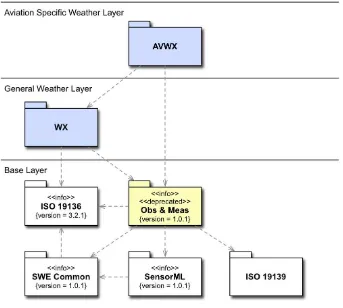
Figure 2: WXXM Weather Data Model
6.1.2 Design Considerations
The ISO 19136:2007 (GML 3.2.1) standard stipulates rules and recommendations regarding the construction of GML application schemas; these constraints are documented in the following clauses:
(a) Clause 7.1: GML model and syntax
(b) Clause 21: Rules for GML application schemas
(c) Annex A.1: Abstract test suite for GML application schemas
6.1.3 Deployment
A team at La Trobe University Melbourne has carried out a mapping of Australian weather messages from a textual format into an XML representation to investigate the issues around the development of a collaborative decision support system, particularly the integration of information in the Aeronautical Information Exchange Model (AIXM) and the Weather Exchange Model (WXXM).
The Australian briefing system publishes ICAO Annex 3 weather messages to the Australian industry via many methods. The messages used for the work at La Trobe University were intercepted from the Aeronautical Fixed Telecommunications Network (AFTN). Message types include TAF, METAR, SPECI, TTF and AREA messages.
6.1.3.1 Design Considerations
An Interface Control Document (ICD) published for weather message dissemination in Australia defines the grammar for each message type. An XML schema was designed to correspond to the structure of the message grammars for each type in the ICD document with some inclusions. Message instances based on this schema were transformed by the use of XSLT. TAF messages were used as a test case. Figure 3 shows a snapshot of a WXXM conversion for an Australian TAF message.
The XSLT sheet contains the mapping structure from text into WXXM
Figure 3 Mapping Process
6.1.3.2 Deployment Issues and Recommendations
6.1.3.2.1 Schema Extensions
Schema extension was required to capture the message grammars published for the Australian data.
Provisional TAF
In Australia an aerodrome report can be deemed provisional if it is likely to be deficient in accuracy by virtue of its origination.
Capture Australian textual descriptors describing cloud, weather and wind information
6.1.3.2.2 Non ICAO forecast information
Australia publishes aerodrome forecasts which include forecasts as per ICAO Annex 3. Exploiting of the remark area (RMK) of the message, a 12-hour period projection for the temperature and QNH are included.
6.1.3.2.3 Enumeration Conflicts
Enumerations for Australian data are mapped to WXXM with a high level of
correspondence. However, some groups of enumerations were in conflict or needed an extension for weather, cloud and turbulence information.
6.1.4 Issues and Recommendations
6.1.4.1 Overview
Issues and recommendations are classified under the following headings:
General Issues
Issues that may impact more than one domain of the WXXM model.
Generic Weather Domain Issues
Issues relevant to the generic weather sub-domain of WXXM.
Aviation Weather Domain Issues
Issues relevant to the aviation sub-domain.
6.1.4.2 Specific Rules in Naming GML Schema objects
UpperCamelCase naming convention for Object element names
UpperCamelCase naming convention for Complex Type names
lowerCamelCase naming convention for Property names
Type name suffix convention ‘Type’ should be at the end of Complex Type name
Abstract element naming conventions ‘Abstract’ should be at the beginning the element name
6.1.4.3 General Issues
No version information is provided for any schemas.
Resolution of relative XLink references. The xml:base attribute is not declared in any WXXS schema. A consequence of this is the resolution of relative XLink references, in particular those that are not same-document references. This may be problematic in cases such as when data is retrieved via WFS.
No object property rule violations were identified by the automated scan.
6.1.4.4 Generic Weather Domain Issues
Abstract features in wxCoverage.xsd nominally can be instantiated:
wx:AbstractCoverageDomain, wx:AbstractCoverage.
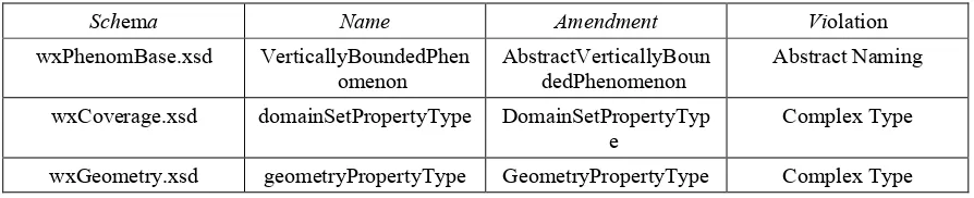
6.1.4.4.1 GML Naming Violations
Table 1: WX Non Naming Conformance to GML
Schema Name Amendment Violation
wxPhenomBase.xsd VerticallyBoundedPhen omenon
AbstractVerticallyBoun dedPhenomenon
Abstract Naming
wxCoverage.xsd domainSetPropertyType DomainSetPropertyTyp e
Complex Type
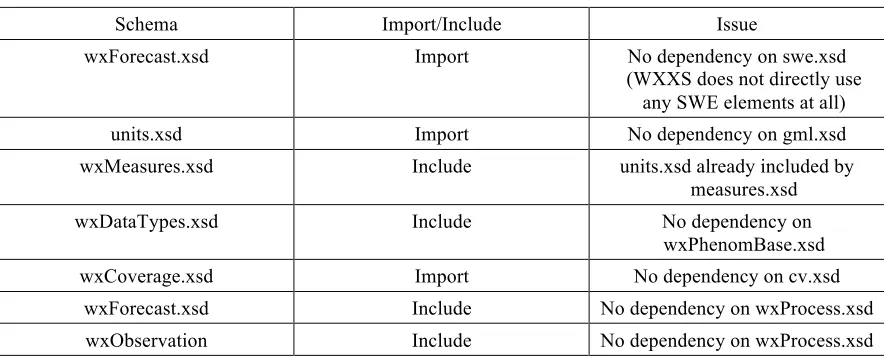
6.1.4.4.2 Spurious Imports and Includes
Table 2: Redundant Imports and Includes
Schema Import/Include Issue
wxForecast.xsd Import No dependency on swe.xsd
(WXXS does not directly use any SWE elements at all)
units.xsd Import No dependency on gml.xsd
wxMeasures.xsd Include units.xsd already included by measures.xsd
wxDataTypes.xsd Include No dependency on
wxPhenomBase.xsd
wxCoverage.xsd Import No dependency on cv.xsd
wxForecast.xsd Include No dependency on wxProcess.xsd
wxObservation Include No dependency on wxProcess.xsd
6.1.4.4.3 Disjoint Referencing
The wx:AbstractWxFeature may be related to any GML feature which may not be the intent. Nothing can substitute for wx:AbstractMeasure(measures.xsd): Speed, Percentage, Temperature, Distance, Angle, Luminance, Pressure all have
corresponding subtypes but are not placed in a substitution group.
WeatherPhenomenonPropertyType (wxPhenomBase) is defined using the GML property type pattern. However, wx:WeatherPhenomenon does not represent a GML object but simple properties that can never be referenced in the usual manner (i.e. using a shorthand pointer1).
WeatherModifierPropertyType (wxDataTypes) is defined using the GML
property type pattern. However, wx: WeatherModifier does not represent a GML object but simple properties that can never be referenced in the usual manner.
AbstractMeasurePropertyType (measures.xsd2) is defined using the GML
property type pattern. However, wx:AbstractMeasure is not a GML object and can never be referenced in the usual manner.
1 Alternative XPointer schemes might be used in some contexts.
wx:Forecast/relatedObservation may refer to any GML feature, which may not be desirable.
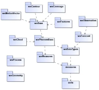
6.1.4.4.4 Redundancies and General Issues
Duplicated (anonymous) type definitions in wxForecast.xsdand in other WX schemas. Observations and Measurements 1.0 3is deprecated. Consider upgrading
to the current v2.0 release (OGC 10-025r1), which uses GML 3.2.1 so an “adapter” is not required.
A circular dependency exists between the wxBase and wxPhenomBase schemas. While this is not a critical shortcoming, these are best avoided as they can pose complications for profilers.
With this change, the (include) dependencies among the WX schemas are shown in Figure 4 Weather Domain Schema Dependencies.
6.1.4.5 Aviation Domain Issues
6.1.4.5.1 GML Naming Violations
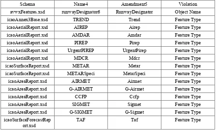
Table 3: AVWX Domain GML Naming Non Conformance
Schema Name4 Amendment5 Violation
avwxFeatures.xsd runwayDesignator6 RunwayDesignator Object Name
icaoAnnex3Base.xsd TREND Trend Feature Type
icaoAerialReport.xsd AIREP Airep Feature Type
icaoAerialReport.xsd AMDAR Amdar Feature Type
icaoAerialReport.xsd PIREP Pirep Feature Type
icaoAerialReport.xsd UrgentPIREP UrgentPirep Feature Type
icaoAerialReport.xsd MDCR Mdcr Feature Type
icaoSurfaceReport.xsd METAR Metar Feature Type
icaoSurfaceReport.xsd METARSpeci MetarSpeci Feature Type
icaoAreaReport.xsd AIRMET Airmet Feature Type
icaoAreaReport.xsd G-AIRMET G-Airmet Feature Type
icaoAreaReport.xsd CCFP Ccfp Feature Type
icaoAreaReport.xsd SIGMET Sigmet Feature Type
icaoAreaReport.xsd G-SIGMET G-Sigmet Feature Type
icaoSurfaceForecastRep ort.xsd
TAF Taf Feature Type
6.1.4.5.2 Spurious Imports and Includes
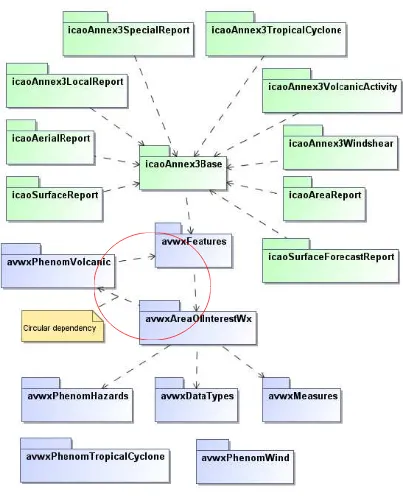
Spurious import in avwx.xsd: there is no apparent dependency on swe.xsd in any AVWX schemas.
Spurious import of gml.xsd in avwxDataTypes.xsd.
Several spurious include dependencies appear. The actual schema dependencies are shown in the Figure 5 package diagram. Note the circular dependency
involving the avwxAreaOfInterestWx, avwxPhenomVolcanic, and avwxFeatures schemas.
4 Expand the acronym if appropriate
5 Also update all related type definitions accordingly
Figure 5: WXXM Schema Dependencies
6.1.4.5.3 Disjoint Referencing
.
Unfounded GML property types defined in avwxMeasures. The references are neither GML objects nor possess schema-determined identifiers.
Profligate use of anonymous property types in icaoAnnex3VolcanicActivity.xsd, icaoAnnex3Windshear.xsd, icaoAreaReport.xsd, icaoSurfaceForecastReport.xsd .
VolcanicActivity/volcano property (in avwxPhenomVolcanic.xsd) has an anonymous type definition that resembles avwx:VolcanoPropertyType.
VolcanicActivityReport (icaoAnnex3VolcanicActivity.xsd) makes no use of the schema components in avwxPhenomVolcanic.xsd.
6.1.4.5.4 Redundancies and General Issues
The element declaration “isDefinedFor” (in avwxAreaOfinterestWx.xsd) has an anonymous type definition that is not consistent with the Schematron assertions.
Redundant name property in avwx:TropicalCyclone7. The type inherits gml:name
(0..*) from gml:AbstractGMLType.
TropicalCycloneAdvisory/number property (icaoAnnex3TropicalCyclone) allows negative integers.
Redundant description property on VolcanicActivityType in avwxPhenomVolcanic.xsd. The type inherits gml:description from gml:AbstractGMLType.
6.1.5 WXXM Coverage Representation
6.1.5.1 Introduction
WXXM extensively uses coverages. These are defined in the WXXM WX_Coverage package as one possible implementation of the ISO 19123 coverage model.
7This also applies to the following types defined in avwxFeatures.xsd: MeteorologicalWatchOfficeType,
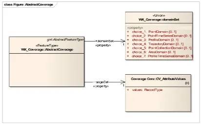
Figure 6: The WXXM Coverage structure
Figure 6 shows the concrete (instantiable) coverage types defined in WXXM.
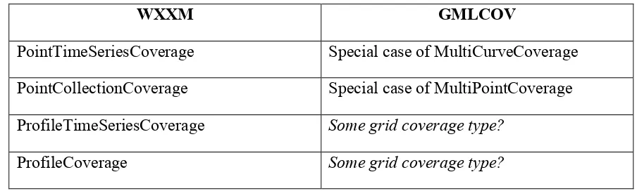
With the WXXM coverage hierarchy shown in Figure 7, it appears that it doesn’t align closely with the ISO 19123 definitions. For example, the WXXM PointCoverage corresponds to the ISO 9123 CV_DiscretePointCoverage; WXXM ProfileTimeSeries does not have a correspondence in ISO 19123; etc.
The Northrop Grumman Technical Paper suggests that “the main issue in dealing with the above types of data has been that the ISO coverage model specifically restricts coverages to 4D (1-3 spatial dimensions and 0-1 time dimension)”. This report is
specifically focused in scope on dealing with the two data types (i.e. Forecast model runs and Radar data) and encoding them into an ISO 19123:2005 compliant coverage. The position postulated by the weather community, referred to in Annex B: OWS-8 section 4.5.2.3.2 is that if additional dimensions are required in order to record this information, the resulting artifact would be non-compliant with the ISO 19123:2005 coverage model. Here again the question is that of domain versus range. The ISO 19123:2005
specification limits the domain (collection of direct positions) to the four spatial-temporal dimensions as previously noted.
On a side note, there seem to be some copy-and-paste errors resulting from copying and modifying GML schema code. For example, DiscreteCoverage (wxCoverage.xsd) is documented as “This element serves as the head of a substitution group which may
contain any discrete coverage whose type is derived from gml:DiscreteCoverageType”
whereas this element certainly is not meant to be in the gml namespace.
6.1.5.2 Comparison with OGC coverage model, GMLCOV
Both WXXM and GMLCOV share the notion of a coverage consisting of domain and range. Further, the approach of sub-typing an abstract coverage into instantiatable con-crete coverage types is common to both. The coverage types provided by WXXM and GMLCOV are compared in Table 4. Note that this does not mean schema compatibility, rather this inspects informational contents.
Table 4: WXXM vs. GMLCOV coverage types
WXXM GMLCOV
PointTimeSeriesCoverage Special case of MultiCurveCoverage PointCollectionCoverage Special case of MultiPointCoverage ProfileTimeSeriesCoverage Some grid coverage type?
PointCoverage MultiPointCoverage
TrajectoryCoverage MultiCurveCoverage
No correspondence RectifiedGridCoverage
No correspondence ReferenceableGridCoverage
No correspondence GridCoverage (Deprecated)
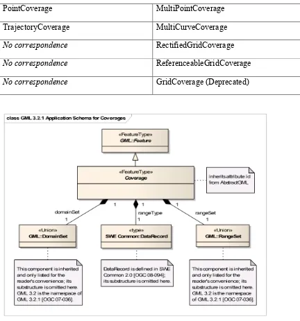
Figure 8: The GMLCOV Coverage structure
The major differences between the two models can be summarized as:
WXXM coverages do not have a range type definition like GMLCOV. This element has been added to provide comprehensive information about the range (“pixel”) data structures. Hence, the WXXM coverage is informationally incomplete.
spatial/temporal domain (as per ISO 19123)”. While GML already considers time, the new element actually is not compatible when disregarding the extra item added.
Another example for incompatibility is the special treatment of z coordinates codified into element names, rather than explicit semantics:
<element name="timePositionList" type="wx:TimePositionListType"/> <element name="locationZ" type="gml:DirectPositionListType"/> <element name="location" type="gml:DirectPositionType"/>
This will lead to problems in the context of n-D coverages and CRS handling.
The range set is modeled as a SWE Common DataRecord. This actually allows more than the set and sequence concepts of coverages, but also, for example, structs and arrays, as well as arbitrary nesting. As such, it transcends the idea of a coverage and is incompatible with GML and GMLCOV.
In summary, the WXXM model is different from the OGC definition of coverages, as laid down in [OGC 10-146r1] and in the sequel abbreviated as GMLCOV, to the extent that it indeed is incompatible. In other words,
implementations adhering to said OGC coverage definition will not be able to produce or consume WXXM coverages, and vice versa.
On a side note, it is a common misconception that relying on ISO 19123 yields interoperable coverage definitions. ISO 19123, by its purpose and definition, establishes an abstract coverage model on which many diverging
implementations can be based. To achieve concrete interoperability, one such concrete implementation model has to be chosen.
6.1.5.3 Recommendation
It is recommended to base the WXXM coverage concept on the common OGC definition of coverages to achieve interoperability at the document and service level. Technically, this means replacing the coverage root WX_AbstractCoverage by GMLCOV::Abstract-Coverage. Those coverage types not yet present in the (generic) OGC coverage model might be introduced, in collaboration with the WCS.SWG. In principle, there are two options:
Define an Application Profile specification (as has been done in the Earth Observation domain with EO-WCS).
Write a Change Request to add further coverage types to GMLCOV.
various stakeholder groups. According to EO-WCS experience, XML definitions can be conveniently crafted through a combination of XML Schema and Schematron.
Generally, it is strongly recommended to liaise with the WCS.SWG for coverage model-ing, as the WCS.SWG is the central maintenance point for coverages in OGC. This ensures harmonization and interoperability across communities.
This should not constitute a devaluation of the work accomplished. On the contrary, the contributions made by WXXM are of great value in the further development of the concept of coverages for manifold practical use cases.
Consequences if not done:
WXXM uses the term “coverage” without compatibility to OGC coverage concept; this can lead to confusion in the target communities and, hence, is adverse to OGC’s mission.
WXXM coverages cannot be used interchangeably with other coverages in OGC at the instance level.
WXXM coverages cannot be served through OGC conformant WCS services, plus further services like WCPS, EO-WCS, forthcoming WPS coverage processing application profile, and others in future.
In particular, WXXM cannot make use of the coverage encoding format
extensions currently under development within OGC (ie, in OWS-8), as these are fitted into GMLCOV.
6.2 Unit of Measure (UOM)
6.2.1 Overview
We identify three categories of issues in relation to distributed Unit of Measure (UOM) namely the encoding, deployment, and interoperability of UOM. We define these groupings as part of the weather’s group thoughts, discussions and incremental explorations on the issues surrounding distributed UOM in general. Each of these categories will be discussed in the following sections.
6.2.1.1 Encoding Allignment
The pre-defined UOM may be:
based on the International Systems of Units (SI), or other conventional /well-known systems for general geospatial domains.
based on the unit of measures defined in the underlying model of the application, e.g. Weather Exchange Model unit of measures for weather related applications.
New UOMs that are not specified in the pre-defined dictionary will have to be ‘derived'
from the existing pre-defined unit. The new UOM will be represented in a UOM repository together with the conversion/derivation method.
The standard representation of the UOM encoding remains an issue to be convened. The following section is a summary of the contributions of:
https://portal.opengeospatial.org/twiki/bin/view/OWS8/AviationWeatherWxxm#Harmoni zation
http://metadata.ces.mil/mdr/ns/GSIP/uom http://metadata.ces.mil/mdr/ns/GSIP/uom/doc Luciad (Jeroen Dries)
Eurocontrol (Eduard Porosnicu) MITRE Corporation (Paul A. Birkel) Jacobs University (Peter Baumann) NCAR (Aaron Braeckel)
Even though AIXM and WXXM are both based on GML all three use a different
measure system. This has already been discussed with the WXXM group in 2010 and in OWS-7. It is widely agreed on that a unification of the measure systems would be preferable. Issues holding back the process are backward compatibility with AIXM 4.5 and uncertainty surrounding the ISO standard forming the basis for UCUM.
The following solutions were proposed:
The use of (OASIS) code lists for the UOMs and schematron.
An own namespace for gml:MeasureType.
The use of UCUM wherever possible.
Linkage between measures and code list.
To create a new complex type that is a <choice> between a gml:MeasureType and a metadata-type (to cater for values such as UNL or CEILING (in AIXM).
Allow for authoritative and common unit and measure definitions from multiple authorities (UCUM, US National Weather Service, ICAO, Eurocontrol) plus their extension.
Allow for distributed, formal definitions (e.g., GML unit dictionaries) that are preferably resolvable (i.e., http://ucum.org/uom/meter).
Allow for non-numeric and mixed numeric and non-numeric types.
Allow for "local" (new) definitions. This could perhaps be handled through local authorities.
6.2.1.2 Deployment
The second challenge is the deployment of the distributed UOM. The basic underlying deployment approach is that UOMs are encoded in a UOM repository, registered, and deployed as simple URL or web services, which are accessible by end-users. While this might be suitable for pre-defined UOMs, which have clear authoritative ownership, there is a need for a clearer guideline for the deployment of new UOMs that considers:
the issue of management, validation, and registration processes of new UOM repositories (created and referenced by different research groups all around the world). There might be a need for a ‘registration' method for a new UOM and a central registry, which hosts a global index of the location/URI of these new UOMs.
the issue of embedding/exchanging a new UOM Dictionary together with the existing WXXM message that utilizes the new UOM versus referencing a ‘registered’ new UOM repository each time the new UOM is used in a WXXM message.
6.2.1.3 Interoperability
The third challenge is the interoperability of the distributed UOMs.
For example, a user may submit a request/query which requires access to a number of UOM repositories. The idea is to have a mechanism for conversion from one UOM repository to another, depending on the context of the user (e.g. geographical location). This requires another set of services on top of the repositories that can convert or translate from one repository to another.
source of the original UOM data provider. This will require a mechanism for conversion from multiple dictionaries to a uniform dictionary.
6.2.2 Architectural Design Options for Distributed UOM
In all cases, it is necessary to maintain a central repository (or a number of mirrored repositories) that contain the so-called base UOMs and conventional UOMs. Base UOMs and conventional UOMs are generally agreed on and widely used (e.g. SI-based UOM).
Every other, new UOM must be derived from a base UOM / multiple base UOMs. This derivation needs to be encapsulated into a remotely accessible method, such as a URL or web service. But the question arises as to where to store these new UOMs and their associated/relevant services.
6.2.2.1 Centralized Architecture
A new UOM is registered at one of the global repositories (which then is mirrored). This needs to be a defined process to ensure correctness.
The shareholder of the new UOM also needs to deliver web services to transform their new UOM into base UOM(s). See Figure 9 for the architecture, Figure 10 for the initialization sequence and Figure 11 for the data exchange sequence.
Figure 10: Centralized Initialization
Figure 11: Centralized Sequence
6.2.2.2 De-Centralized Architecture
Participants can create their own repository. They “register” the new UOM and the associated services in the local repository.
unknown to the receiver, it might become necessary to also access the central, global repository for transformation from base UOM to base UOM. See Figure 12 for the
architecture, Figure 13 for the initialization sequence and Figure 14 for the data exchange sequence.
Figure 12: De-Centralized Architecture
Figure 14: De-Centralized Sequence
6.2.2.3 Local Copy Architecture
This is a third option which minimizes network traffic. Instead of accessing a web service, the necessary translation functionality is downloaded into a local repository. Whenever the receiver needs to transform this particular UOM in the future, they can access it locally. See Figure 15 for the architecture, Figure 16 for the initialization sequence and Figure 17 for the data exchange sequence.
Figure 16: Local Copy Initialization
6.2.2.4 Local Transformation Architecture
In this design base, UOMs and conventional UOMs can be thought of as a standard. All transferred data must be encoded in those UOMs. This means the creator of a new UOM has to transform their data before sending it to a broader audience. This step is
unnecessary if the sender can be sure that the receiver understands his new UOM (e.g. two research groups sharing information). See Figure 18 for the architecture, Figure 19 for the initialization sequence and Figure 20 for the data exchange sequence.
This approach renders it unnecessary to register and maintain new UOMs in a repository outside the creator’s domain. It significantly reduces network traffic and allows for offline applications.
Figure 18: Local Transformation Architecture
Figure 20: Local Transformation Sequence
6.2.3 Deployment
6.2.3.1 Separation of semantic and physical layers
The previous sections focused on the physical architectural design that will facilitate the conversion process in a distributed UOM rather than the representation of the distributed UOM itself (i.e. separation of the semantic and logical layers of the conversion process). It has been suggested to establish a ‘semantic’ or definition layer - separate from the physical deployment layer - which will address the re-use, interoperability and governance issues.
Our exploration takes one form, i.e. the GML dictionary as the encoding representation, simply because we can create scenarios/data sets based on our existing WXXM and AIXM data and explore the possibility of running experiments with the UOM in the data instance itself by following the given UOM GML schema. Other approaches such as UCUM are available as well. Having a generic definition in the semantic layer and then letting local sites deal with their own libraries/services will fit into the “local copy” architecture based on the Design Options as described in section 6.22.
It is necessary to cater for re-use and the potential to reduce governance and management overhead, as well semantic interoperability.
Figure 21: Greater picture architecture
6.2.3.2 Data & Schema
It is necessary to find the transformation corresponding to the currently evaluated
value/UOM. Hence, every XML element which has a UOM attribute must either include its well-known (i.e. standard) name (e.g. m or ft) or the corresponding link to its
transformation web service. Alternatively, one could think of a general link to the repository as an attribute of the root node. See the code listing below and Figure 22 for the schema implementation.
<asa:AustralianTAFProduct
xsi:schemaLocation="http://www.airservicesaustralia.com.au C:/wxxm/AustralianProductsSchemas/AustralianTAFproduct.xsd" gml:id="ID_46c691d5-aa88-4ca6-9879-1e507f065b32"
xmlns:uuid="xalan://java.util.UUID" xmlns:gco="http://www.isotc211.org/2005/gco" xmlns:gmd="http://www.isotc211.org/2005/gmd" xmlns:xlink="http://www.w3.org/1999/xlink"
xmlns:wx="http://www.eurocontrol.int/wx/1.1" xmlns:xsi="http://www.w3.org/2001/XMLSchema-instance" xmlns:om="http://www.opengis.net/om/1.0/gml32" xmlns:fn="http://www.w3.org/2005/xpath-functions" xmlns:avwx="http://www.eurocontrol.int/avwx/1.1" xmlns:gml="http://www.opengis.net/gml/3.2" xmlns:asa="http://www.airservicesaustralia.com.au"
xlink:href="urlToGeneralWebService">
<avwx:rawText>
TAF YMGB 180015Z 1802/1811 11010KT 9999 SCT025 RMK
T 30 32 29 28 Q 1011 1009 1008 1011
</avwx:rawText>
<avwx:aerodromeWxForecast>
<om:samplingTime>
<gml:TimePeriod gml:id="ID_f3bdffee-a2c6-4d05-8097-e32943c1a5f8">
<gml:beginPosition>2010-12-18T 02:00:00Z</gml:beginPosition>
<gml:endPosition>2010-12-18T 11:00:00Z</gml:endPosition>
</gml:TimePeriod>
</om:samplingTime>
<om:result>
<avwx:AerodromeWx gml:id="ID_9449d9d2-601c-4187-8ff5-e25feaf815e4">
<avwx:windDirection uom="deg">110</avwx:windDirection>
</avwx:aerodromeWxForecast> </asa:AustralianTAFProduct>
Figure 22: UOM in the Schema
6.2.3.3 Transformation
Figure 23: UOM Transformation step by step
6.2.3.4 Profiles
UOM Profiles could play a vital role in the area of distributed UOM and would allow the alignment of sender and receiver, which minimizes the number of necessary
transformations. This can minimize calculation errors as well. Figure 24 visualizes this approach in the Local Transformation environment.
Figure 24: UOM Profiles
6.2.3.5 Implementation
Figure 25: Process implementation
An Input XML file (here WXXM, see below) is scanned for unknown UOMs by a
Scanner Process. This process refers to a profile outlining known UOMs. Transformer 1
is only used in cases where unknown, new UOMs are found in the input file. If all UOMs used in the input file are known to the system, nothing happens and the output file is identical to the input file.
<avwx:AerodromeWx gml:id="KCRW_04">
<avwx:windDirection uom="deg">0</avwx:windDirection> <avwx:windSpeed uom="kt">0</avwx:windSpeed> <avwx:cloudCondition>
<wx:CloudCondition gml:id="KCRW_05">
<wx:base uom="ogs.cs.latrobe.edu.au/newUOM">10500</wx:base> <!-- used to be 25000 ft -> * 0.42 (fictional new UOM) --> <wx:cloudAmount>SCATTERED</wx:cloudAmount>
</wx:CloudCondition> </avwx:cloudCondition> </avwx:AerodromeWx>
<gml:Dictionary gml:id="ID_1"
<gml:ConventionalUnit gml:id="newUOM"> <gml:name>new UOM</gml:name>
<gml:quantityType>distance</gml:quantityType> <gml:catalogSymbol>nU</gml:catalogSymbol> <gml:conversionToPreferredUnit uom="#ft"> <gml:factor>0.42</gml:factor> </gml:conversionToPreferredUnit> </gml:ConventionalUnit>
</gml:dictionaryEntry> </gml:Dictionary>
It is now necessary to create an actual transformation implementation of the new UOM. In this example, XSLT is used to achieve this (Transformer 1, see below). Transformer 1 uses the UOM definition as input and creates an XSLT template for this specific UOM. The template will transform an element with a UOM attribute with the unknown UOM as its value. It incorporates the gml:factor information as well as the gml:
conversionToPreferredUnit value. In a similar fashion, gml:formula with its up to four
child nodes corresponding to y = (a + bx) / (c + dx) could be facilitated instead of the gml:factor.
<xsl:stylesheet version="2.0" xmlns:xsl="http://www.w3.org/1999/XSL/Transform"
xmlns:xs="http://www.w3.org/2001/XMLSchema" xmlns:fn="http://www.w3.org/2005/xpath-functions" xmlns:gml="http://www.opengis.net/gml" >
<xsl:output method="xml" version="1.0" encoding="UTF-8" indent="yes"/> <xsl:template match="/gml:Dictionary/gml:dictionaryEntry/gml:ConventionalUnit">
<xsl:text disable-output-escaping="yes"><![CDATA[<xsl:template match="node()[@uom=']]></xsl:text> <xsl:value-of select="gml:catalogSymbol"/>
<xsl:text disable-output-escaping="yes"><![CDATA[']">]]></xsl:text>
<xsl:text disable-output-escaping="yes"><![CDATA[<xsl:variable name="factor" select="]]></xsl:text> <xsl:value-of select="gml:conversionToPreferredUnit/gml:factor"/>
<xsl:text disable-output-escaping="yes"><![CDATA["/>]]></xsl:text>
<xsl:text disable-output-escaping="yes"><![CDATA[<xsl:element name="{name()}">]]></xsl:text> <xsl:text disable-output-escaping="yes"><![CDATA[<xsl:attribute name="uom">]]></xsl:text> <xsl:value-of select="substring(gml:conversionToPreferredUnit/@uom,2)"/>
<xsl:text disable-output-escaping="yes"><![CDATA[</xsl:attribute>]]></xsl:text>
<xsl:text disable-output-escaping="yes"><![CDATA[<xsl:value-of select=". div $factor"/>]]></xsl:text> <xsl:text disable-output-escaping="yes"><![CDATA[</xsl:element>]]></xsl:text>
<xsl:text disable-output-escaping="yes"><![CDATA[</xsl:template>]]></xsl:text> </xsl:template>
</xsl:stylesheet>
The resulting XSLT template is created as output (see below). This happens dynamically and as a result of the UOM definition.
<xsl:template match="node()[@uom=’ogs.cs.latrobe.edu.au/newUOM’]"> <xsl:variable name="factor" select="0.128016"/>
<xsl:element name="{name()}">
</xsl:template>
Together with an XSLT Framework which only copies input to output (for all those known UOMs and elements without the UOM attribute) this forms Transformer 2 (see
XSLT Framework below).
<xsl:stylesheet version="2.0" xmlns:xsl="http://www.w3.org/1999/XSL/Transform"
xmlns:xs="http://www.w3.org/2001/XMLSchema" xmlns:fn="http://www.w3.org/2005/xpath-functions" xmlns:wx="http://www.eurocontrol.int/wx/1.1">
<xsl:output method="xml" version="1.0" encoding="UTF-8" indent="yes"/>
<xsl:template match="@*|node()"> <xsl:copy>
<xsl:apply-templates select="@*|node()"/> </xsl:copy>
</xsl:template> </xsl:stylesheet>
When applied to the original Input WXXM file, it transforms the new UOM to its base UOM while copying everything else to the output without change. The resulting Output WXXM looks like this:
<avwx:AerodromeWx gml:id="KCRW_04">
<avwx:windDirection uom="deg">0</avwx:windDirection> <avwx:windSpeed uom="kt">0</avwx:windSpeed> <avwx:cloudCondition>
<wx:CloudCondition gml:id="KCRW_05"> <wx:base uom="ft">25000</wx:base>
<wx:cloudAmount>SCATTERED</wx:cloudAmount> </wx:CloudCondition>
</avwx:cloudCondition> </avwx:AerodromeWx>
Figure 26: Web Implementation
6.2.4 Issues and recommendations
This section discusses the issues found and possible recommendations. It compares the different architectures, presents thoughts about performance and localization as well as the use of UOM profiles.
6.2.4.1 Comparison
Table 5 compares the different architectures discussed earlier.
Local Copy inherits the shortcomings of the centralized approach but would perform better by reducing network traffic. It is important to keep in mind that reliability and security can only be achieved if updates are properly managed.
Local Transformation, on the other hand, outperforms the previous approaches in terms of network traffic and performance. However, as it restricts encoding to the known standard only, it lacks flexibility and support for the new UOM in the long term.
Table 5: Comparison of different UOM architectures
Centralized De-Centralized Local Copy Local Transform
Network traffic - - + +
Registration process - + - -
Growing repository - + - -
Political issues - + - -
Availability + - + +
Reliability + - +8 +8
Security + - +9 +9
Performance - - + +
In our implementation approach, we use the local copy architecture combined with a de-centralized repository. This provides a highly flexible system while catering for network traffic and performance. Certainly, availability, reliability and security are challenges which need further discussion in this scenario.
6.2.4.2 Performance: what is desired, what is to be expected?
Performance will be a critical criterion in a real-time environment such as in-flight updates. After speaking to industry shareholders, it became clear that XML data with its tag overhead might be a problem in itself. An online connection to transform data “on the fly” seems to be out of the question for some applications.
It is considered beneficial to conduct a series of real-life benchmarks and surveys to obtain a better understanding of current performance, possible performance and required minimum performance.
8 If updates are managed.
6.2.4.3 Local versus remote access
Remote access raises the connectivity issue. It might be complicated to ensure that an application can, at any time, access a remote service via a network. Local services might not always be available and could be compromised by a third party.
The Local Transformation takes remote or local services out of the equation and replaces them with a local transformation plus a de-facto UOM standard.
6.2.4.4 Version Management
With the architecture proposed in section 6.2.3 on page 32, only the definition of a new UOM is stored in a centralized or decentralized repository. The actual implementation, on the other hand, remains under the control of the user of the data. This raises the question of how to push new versions of a UOM definition to the shareholders. This will need further discussion should the approach with separated definition and implementation be applied. One possibility would be to include a version number in the UOM attribute’s value. A new version would be considered a new UOM all together which requires a new implementation. Different versions could co-exist.
6.2.4.5 Open vs. Secure
There may not be “one solution that fits all” for dealing with the distribution of UOM. Instead of either a very open and flexible or very secure system, a level-based
implementation for UOM distribution, depending on the application environment could be considered. A participant could be certified for certain levels.
The levels proposed are:
Level 0 - Zero restrictions: new UOM definitions and implementations can be hosted locally, without a registration process.
Level 1 - Centralized repository for UOM definitions; new UOMs can only be added via a stringent verification process.
Level 2 - Only known/standard UOMs are shared; new UOMs are kept only locally (e.g. in a research institution); they are converted locally into the standard UOMs (using a conversion function hosted by the owner of the UOMs) before sharing the data.
Level 3 - Highest restriction: no new UOMs are allowed as long as “the
6.3 Coordinate Reference System (CRS)
The following sections have been extracted from:
https://portal.opengeospatial.org/twiki/bin/view/OWS8/AviationWeatherCrs
OGC Web Coverage Service specification v 2.0 http://www.opengeospatial.org/standards/wcs
WCS Core change request CR
https://portal.opengeospatial.org/files/?artifact_id=44308
Weather Exchange Information Model WXXM
http://www.eurocontrol.int/aim/public/standard_page/met_wie.html
Encoding Representative Weather Datasets
https://portal.opengeospatial.org/files/?artifact_id=46115
6.3.1 Overview
The Coordinate Reference System (CRS) Domain Working Group develops strategies for encoding the earth coordinate reference systems and transformations between coordinate reference systems. The group has worked consistently on the joint OGC-ISO Document 19111 - Spatial Referencing by Coordinates.
The Aviation Thread of OWS-8 will explore ways to address the following two issues: - How can a WCS client request a specific Coordinate Reference System (CRS) (including projection, projection parameters, datum, etc) when there is no existing EPSG (or other) code associated with the CRS? How can such CRSs be encoded in this case (well-known text, GML, etc)?
- Can a WCS 2.0 server formally advertise the capability to support arbitrary CRSs (as opposed to a fixed number of possible CRSs), as specified in the client query? As a background, in the weather domain, the set of projected spaces of interest to clients is potentially infinite. For example, a data set available in a Lambert Conformal
6.3.2 Design Considerations
The proposed method for referencing CRSs is to use URL.
The issue here is that not all known standardized CRSs are URLified (not even all EPSG codes, not to speak of climate community 4D CRSs etc.). Task here seems to be to
collect, unify, and define URLs.
The challenging task here is that the advanced functionality as offered, e.g., by WCS requires a dynamic axis combination into a new CRS. As these are generated on the fly, as a side effect of coverage processing, they cannot be predefined, hence a client cannot know them in advance. Further, the sheer combinatorial complexity prevents from enumerating them as URLs. So we need a mechanism to transport CRS definitions. Specific core issues are:
Non-standard axis combination. By "non-standard" mainly EPSG is meant. Example: 4D data need a combination of x/y (EPSG!), z, and t (ISO 8601!) axes; x/t slices from such a 4D cube need to return a coverage having an x/t based CRS.
Parametric CRSs. Example: Polar stereographic CRSs can have a reference angle of 0 (Greenwich) or any other angle.
"Abstract" axes: axes having no spatio-temporal semantics, such as "extra" time axes, pressure, products offered, etc.
6.3.3 Deployment
Following the evaluation of different approaches, the following set of work items has been suggested for the deployment:
1. WCS Core change request CR: adding a CRS GetCoverage request parameter and provision of CRSs supported in the Capabilities. The Change Request can be found at: https://portal.opengeospatial.org/files/?artifact_id=44308
2. Complete replacement of 07-092r3 through the creation of an OGC-NA Name Type Specification (NTS) for predefined, combined, and parameterized CRSs to augment the /def/ NTS (which defines http URIs for standard CRS).
3. Devise AUTO CRS definitions.
4. Specification of CRS registry service (cf. WCTS).
6.3.4 Issues and Recommendations
Aaron Braeckel has raised the issue of Client/server differentiation:
How would clients request a specific CRS (including projection, projection parameters, datum, etc.) where there is no existing EPSG (or other) code that covers it?
How would servers formally advertise the capability to produce arbitrary CRSs?
Other issues are:
Issue 1: How to represent ad-hoc combined CRSs in a request capability document etc.? Following different considerations including the use of URNs, Well-Known Text, URLs, and GML, the recommendation is to establish a registry service resolving complete, combined, and parameterized CRS URLs. This service would return "flat",
non-parameterized GML definitions per invocation (i.e., with good luck we can reuse GML as is).
Issue 2: How to inform clients about CRS support?
Description: A client needs to know in which CRS it can request coverage. To this end, the identifying URLs need to be provided by a server.
Alternatives:
Alternative 1: associate CRSs with the service (ServiceMetadata) and deliver as part of the capabilities.
Alternative 2: associate CRSs with individual coverages (ServiceParameters) and deliver as part of a coverage description.
As delivering information only in the service, not the coverage description saves volume, and since ServiceMetadata is simpler for the client to use, it seems that the use of
ServiceMetadata is a better approach.
6.4 Web Coverage Services (WCS)
The following sections have been extracted from:
http://www.opengeospatial.org/standards/wcs
WCS Core change request CR
https://portal.opengeospatial.org/files/?artifact_id=44308
http://geobrain.laits.gmu.edu/ows8/aviationWCS.html
Encoding Representative Weather Datasets
https://portal.opengeospatial.org/files/?artifact_id=46115
6.4.1 Overview
The OpenGIS® Web Coverage Service Interface Standard (WCS) defines a standard interface and operations that enables interoperable access to geospatial "coverages" [http://www.opengeospatial.org/ogc/glossary/c]. Coverage is a feature that associates positions within a bounded space (its spatiotemporal domain) to feature attribute values (its range). GIS coverages (including the special case of Earth images) are two- (and sometimes higher-) dimensional metaphors for phenomena found on or near a portion of the Earth's surface. A coverage can consist of a set of features or Feature Collections. Earth images are seen as Grid Coverages that contain features whose geometries are of the type "set of cells" or "set of pixels" (surfaces).
The term "grid coverages" typically refers to content such as satellite images, digital aerial photos, digital elevation data, and other phenomena represented by values at each measurement point.
Radar data is sometimes represented in more than 4D representation, such as when multiple radars make observations at the same physical point. The requirement is to recommend ways for representing such 5D data as a WCS coverage.
The analysis of the problem statement concluded that the issue is entirely one of encoding and extending the WCS specification to include governance over content data is
significantly outside the scope of the specification.
6.4.2 Operations
The web coverage service supports the following operations: WCS GetCapabilities