© 2011 Faculty of Humanities, University of Indonesia
I MADE ANDI ARSANA is a lecturer and researcher in the Department Geodetic Engineering, Gadjah Mada University, Indonesia. He is currently an Australian Leadership Awards Scholar (PhD candidate) at the Australian National Centre for Ocean Resources and Security (ANCORS), University of Wollongong. He obtained a master degree from the University of New South Wales, Australia, focusing on the maritime delimitation between Indonesia and Timor Leste. He is also an alumnus of the UN-Nippon Foundation Fellowship, a research and internship program organized by the UN Division for Ocean Affairs and the Law of the Sea (DOALOS). He has been focusing his research on technical/geodetic aspects of the law of the sea, especially
on maritime boundaries and has published several works in the field including, journals, books, popular-scientific articles and conferences both in English and Indonesian. I Made Andi Arsana
may be contacted at: [email protected].
Mending the imaginary wall
between Indonesia and Malaysia
The case of maritime delimitation in the waters off
Tanjung Berakit
I MADE ANDI ARSANA
Abstract
Due to its geographical location, Indonesia shares border areas with at least ten neighbouring countries with which maritime boundaries must be settled.
As of March 2011, Indonesia is yet to finalize its maritime boundaries with
various States including Malaysia with which four maritime boundaries need to be settled: the Malacca Strait, the South China Sea, the Sulawesi Sea, and the Singapore Strait (off Tanjung Berakit). It is evident that pending maritime boundaries can spark problems between Indonesia and Malaysia. The dispute over the Ambalat Block in 2005 and 2009 and an incident in the waters off Tanjung
Berakit on 13 August 2010 are two significant examples. This paper discusses the
incident in the waters off Tanjung Berakit, but will be preceded by a description of the principles of coastal States’ maritime entitlement pursuant to international law of the sea. Following the discussion, this paper provides suggestions for settling maritime boundaries in the area from technical/geospatial and legal perspectives.
Keywords
Indonesia, Malaysia, maritime boundary, delimitation, sovereignty, sovereign rights, technical/geospatial aspects of the law of the sea.
1 Introduction
Frost (1917) seems to be right with his observation that “good fences make good neighbours”.1 This is confirmed by the pattern of relationships between
Indonesia and Malaysia in the last few years. Both countries have yet to settle their maritime boundaries and it is the pending these boundaries that sparked problems and tensions. It is intriguing to observe that these tensions are by
no means new despite both countries’ sincerity in finding solutions.
Tensions built between Indonesia and Malaysia in early 2005 and mid-2009 about the Ambalat Block.2 In Indonesia, the media widely and excessively
covered the issue and aggravated many Indonesian people. It was clear that
the Ambalat issue was not the last unfinished business in relation to pending
maritime boundaries between Indonesia and Malaysia.
In August 2010, similar tensions built once again between the two countries in relation to an incident in the waters off Tanjung Berakit involving
Indonesian officials, Malaysian fishermen and members of the Royal Malaysia
Police (RMP). Like other issues regarding border disputes, the Indonesian media intensely covered the incident causing the tension to build even higher.
The official press release of the Indonesian Ministry of Marine Affairs and Fisheries (MMAF) stated that three officials of a MMAF patrolling team were
arrested by RMP when they were patrolling the waters off Tanjung Berakit. According to a press release, the Indonesian patrolling team was on duty to
protect the maritime area from a group of Malaysian fishermen who were allegedly fishing in Indonesian waters (MMAF 2010). A press release issued
by the Indonesian Minister of Foreign Affairs (MoFA) further asserted that the incident took place in Indonesian waters and that MoFA would be responsibly to do whatever needed to deal with the issue (MoFA 2010a). Similar stories were featured also through newspapers and other electronic news media in Indonesia. At the time of writing (March 2011), no tension is building even
though the issue has not been settled. Both countries are cooperating to find
a solution by intensifying negotiations regarding the delimitation of the maritime boundaries between them.
This paper analyses the aforementioned incident by focusing on technical/
geospatial and legal aspects in the context of sovereignty and/or sovereign
rights. Suggestions for dispute resolution through maritime boundary delimitation by considering legal and technical aspects are also provided. To begin with, the principle of maritime zones and the jurisdiction of coastal States3 are presented, followed by the principle of maritime boundary
delimitation. This part thoroughly describes how coastal States in the world
1 Robert Frost wrote a metaphoric poem entitled “Mending Wall”, published in 1914
and appeared as the first selection in Frost’s North of Boston (see Frost 1917).
2 For a detailed legal and technical analysis of the Ambalat case, see for example,
Arsana (2010).
3 The term ‘coastal State’ refers to a State that geographically connects to sea/maritime
are entitled to the maritime area around their land territory and why they have to share these maritime areas with their neighbours, which is known as
maritime delimitation (United Nations 2000). Since this is a neutral scientific analysis, positions and information expressed here are not those of any
government. However, any relevant parties may consider the suggestions provided in this paper as alternatives in settling maritime boundaries between Indonesia and Malaysia.
2 Maritime claims and delimitation
In modern times, coastal States have extended their authority beyond their land territory to maritime areas. Efforts to this extension can be seen as early as the fifteenth century involving Spain and Portugal through the bullInter Caterea dated on 4 May 1493 by Pope Alexander VI (Davenport 1917: 75-78).4
By the twentieth century, coastal States sporadically claimed maritime areas
adjacent to their land territory. A good example is the proclamation made by the American President, Harry S. Truman, in 1945. The proclamation explicitly
states that “the Government of the United States regards the natural resources of the subsoil and sea bed of the continental shelf beneath the high seas but contiguous to the coasts of the United States as appertaining to the United States, subject to its jurisdiction and control” (Presidential Proclamation No. 2667 1945). This was soon followed by countries in Latin America such as Argentina, Chile, and Peru (United Nations 1982a). At that time, many other
countries also expressed their unilateral claim over the maritime area around
their land territory.
In order to regulate these sporadic and unilateral maritime claims by
coastal States, the United Nations (UN) implemented a codification process, which officially started in 1958 (United Nations 1958). The most recent codification process was the United Nations Conference on the Law of
the Sea (UNCLOS) III concluded in 1982 in Montego Bay, Jamaica, after a nine-year-long negotiation process. In the conclusion of the conference, the
United Nations Convention on the Law of the Sea 1982 was finalized and
open for signing. The world has embraced this Law of the Sea Convention (hereinafter referred to as the LOSC)5 ever since (United Nations 1982b).
LOSC is considered the most comprehensive law of the sea convention ever and is termed “A Constitution of the Ocean” (Koh 1982: 1). Both Indonesia and Malaysia are parties to the convention, which means that both countries
ratified the LOSC, and have adopted it in their national laws and regulations.
Pursuant to the LOSCa coastal State is entitled to zones of maritime jurisdiction measured from its baselines. In accordance to the LOSC, coastal States can opt to designate ”normal” baselines (LOSC, Article 5) or straight baselines (LOSC, Article 7). According to the LOSC (Article 46), a State
that qualifies as an archipelagic State can designate archipelagic baselines
4 For a detailed historical context of the bull Inter Caterea, see Van der Linden (1916). 5 United Nations Conventions on the Law of the Sea (LOSC), opened for signature 10
“joining the outermost points of the outermost islands and drying reefs of the archipelago” (LOSC, Article 47). Being an archipelagic State, Indonesia is entitled to archipelagic baselines. In addition to these, baselines can also include lines closing mouths of rivers (LOSC, Article 9) and mouths of bays (LOSC, Article 10), and baselines related to ports (LOSC, Article 11) and roadsteads (LOSC, Article 12). A State may use a combination of different types of baselines to construct the overall baseline around its coastline (LOSC, Article 14). In the Indonesian case, archipelagic baselines serve as a belt enclosing the entire archipelago that encompasses big and small islands. This belt serves as the reference from which maritime zones are measured.
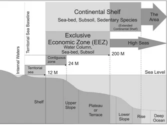
Measured seaward from its baselines, a coastal State may theoretically claim the full suite of zones of maritime jurisdictions provided for in accordance with the LOSC. These zones include a twelve-nautical-miles (M)6
breadth territorial sea (LOSC, Article 3), a contiguous zone out to 24 M from
baselines (or 12 M from territorial sea limits) (LOSC, Article 33), an exclusive
economic zone (EEZ) out to 200 M (LOSC, Article 57) and a continental shelf
that may extend up to 350 M or even more (LOSC, Article 76) as Figure 1
illustrates. The outer limits of a continental shelf, unlike the limits of other zones, which depend only on distance, depend also on the geology and the geomorphology of the seabed. That is why the outer limit of a continental
shelf is not as fixed as other zones. In addition to the aforementioned zones,
a coastal State is also entitled to, when applicable, internal waters measured landward from baselines.
6 The symbol used for nautical miles in this paper is ”M”, where 1 M = 1,852 metres.
Figure 1. Maritime jurisdictions of a coastal State pursuant to the LOCS
Technically speaking, a maritime claim involves the application of
geospatial discipline such as sea tide observation/definition in defining baselines. Geodetic application is also involved in, for example, defining the
distance from baselines to the outer limits of a particular maritime zone. For practical purposes, distances are measured on a nautical chart so that nautical charts play an important role in maritime claims and delimitations (Arsana and Sumaryo 2008).
For each maritime zone, coastal States exercise either full sovereignty or sovereign rights limited to specific purposes. Coastal States have sovereignty
over internal waters, over archipelagic waters within archipelagic baselines
(such as those defined by archipelagic States) and over the territorial sea. With regard to all of these zones, coastal State’s sovereignty extends through the
seabed and subsoil, to the water column and airspace above. Within the EEZ
and the continental shelf, by contrast, coastal States have specific sovereign rights (not full sovereignty) to utilize and manage natural resources (fishing,
oil and gas mining, etcetera). While the EEZ relates to both seabed and subsoil and the water column above the seabed, the continental shelf relates solely to the seabed and the subsoil.7 The High Seas are that part of the sea that
excludes the EEZ, the territorial sea or the internal waters of a coastal State, or
the archipelagic waters of an archipelagic State (LOSC, Article 86). The Area covers the seabed region beyond coastal States’ continental shelf, which is considered the common heritage of mankind (LOSC, Article 136).
A further difference between the various maritime zones of jurisdiction is that some of them, such as the EEZ, require an active claim on the part of the coastal State while some do not. In particular, continental shelf rights are inherent and “do not depend on occupation, effective or notional, or on any
express proclamation” (LOSC, Article 77 (3)). This means that a coastal State may explore and utilize natural resources within its continental shelf without making an express claim to it. The basis for this distinct treatment rests on
the concept that the coastal State possesses rights to its continental shelf as the “natural prolongation of its land territory” into and under the sea (LOSC,
Article 76 (1)). LOSC provides that a coastal State’s continental shelf extends
beyond the limits of its territorial sea “to the outer edge of the continental margin” or, to 200 M from its relevant baselines where the continental margin
does not extend to that distance. The procedure to delineate the outer limits
of the continental shelf beyond 200 M is set out in Article 76 of the LOSC. The limits of a coastal State’s maritime jurisdiction can be established in
one of three ways. First, maritime claims can be generated to the full extent
allowed for under international law, provided there are no analogous claims by neighboring States. Second, where overlapping claims to maritime jurisdiction
exist, maritime boundaries may be delimited between neighbouring States.
Thirdly, with respect to continental shelf limits, the delimitation of its outer
7 It is worth noting, however, that rights over seabed and subsoil claimed as part of
the EEZ under Part V of LOSC are exercized in accordance with LOSC Part VI dealing with
limits involves a submission process to the United Nations Commission on the Limits of the Continental Shelf (CLCS) as previously mentioned.
Provided that a coastal State does not have any neighbours making
overlapping claims for a particular zone, it can define its maritime limits unilaterally. For example, if the coastal State has no neighbours within 24 M distance from its baselines, it can unilaterally define its territorial sea limits.
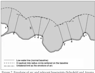
With regard to this option, the outer limits of maritime zones are commonly
defined using the method of envelope of arc (Carleton and Schofield 2001) as
illustrated by Figure 2. The limits of such claims are generally dependent on the baselines from which these maritime claims are measured and thus may change as the baselines shift. However, it is worth noting that this method employs only relevant basepoints along baselines to generate maritime limits.
Depending on the shape and the configuration of the baselines, not every point along these baselines will dictate the location of maritime limits (Schofield
and Arsana 2010). In other words, while some parts of the baselines may be crucial in constructing maritime limits, other parts may not contribute to the
same extent due to their geographical locations along the baselines. However,
it is generally true that changes in baselines can shift maritime limits.
Figure 2. Envelope of arc and relevant basepoints (Schofield and Arsana 2010: 8).
It has been observed that if all coastal States were to make their maximum
maritime claims permitted by the LOSC, around 44.5% of the world ocean could possibly fall under some form of national jurisdiction. This means that
without having overlapping claims with its neighbours. To be able fully to
claim the EEZ, for example, the distance of a coastal State from its neighbours
must be at least 400 M (that is, the breadth of two EEZs). In case of a continental shelf, the distance required may be even more (LOSC, Article 76). However, this situation does not affect the way the breadth of maritime zones is, theoretically, measured from baselines.
Considering the geographical location of coastal States in the world and
the configuration of their coasts, overlapping claims of maritime zones among
coastal States is inevitable (see Figure 3). Consequently, maritime delimitation differentiates maritime boundaries. Maritime delimitation between States is
therefore another way for coastal States to define the limits of their maritime zones. While the first option is a unilateral process, maritime delimitation
in the second option is a bilateral or multilateral process. The agreed line resulting from the delimitation process will then serve as the outer limit of
maritime zones of a coastal State. In other words, in many cases, the definition
or the outer limits of maritime zones/jurisdiction cannot be accomplished unilaterally but multilaterally where overlapping claims occur among several States.
In line with the above principle, Indonesia, for example, cannot unilaterally define the outer limit of its territorial sea in maritime area to the north of Batam
and Bintan Islands (the Singapore Strait) since the breadth of the strait is less than 24 M. The shortest distance between Indonesia’s archipelagic baselines
and Singapore’s Pulau Sentosa, for example, is around 7 kilometers, which
equals 3.8 M.8 If Indonesia defines the breath of its territorial sea up to 12 M
northward then the claim will encompass Singaporean and Malaysian land territories. This is undoubtedly unfair for Malaysia and Singapore, which also posses the same rights or entitlements over maritime area as they, like Indonesia, are also parties to the LOSC. To overcome the potential overlapping
claim, the three countries need to compromise and define lines to divide
maritime entitlements among them. Following the provision set forth by the LOSC, Indonesia has ten neighbouring countries with which maritime boundaries need to be settled. Those countries are India, Thailand, Malaysia, Singapore, Vietnam, the Philippines, Palau, Papua New Guinea, Australia and Timor-Leste (Oegroseno 2009). It is understandable that maritime delimitation is by no mean an easy task for Indonesia with that many neighbours.
The process of maritime boundary delimitation between two or more coastal States is governed by the principles and rules of public international
law (Prescott and Schofield 2005). International law provides the “rules of the game” explaining how maritime boundary delimitations should be
established. However, maritime boundary delimitation is usually resolved either through negotiation among affected parties or by submission of the
case to a third party (Prescott and Schofield 2005). This third party can be
8 Measurement was conducted on British Admiralty Chart (BAC) Number 3831 of the
arbitrators, mediators, courts, or tribunals such as the International Court of Justice (ICJ)9 and the International Tribunal for the Law of the Sea (ITLOS).10
Figure 3 shows that overlapping claims takes place in the EEZ and the continental shelf because the distance between State A and B is less than 400 M but more than 24 M. If the distance between two neighboring States is less than 24 M, their territorial seas will overlap. This is to illustrate that maritime boundary delimitation can be required for the territorial sea, the EEZ, or the continental shelf, depending on the distance between the States in question. In this regard, rules governing maritime boundary delimitation for these different
zones are also different. For the territorial sea, for example, it is explicitly stated
in the LOSC that “neither of the two opposite or adjacent States is entitled to
extend its territorial sea beyond the median line” unless either State involved agrees otherwise, or due to the existence of “historic title or other special
circumstances” (LOSC, Article 15). It is understood from this provision that
the method to delimit the territorial sea is explicitly mentioned in the LOSC
as the median or equidistance line.11 However, the LOSC does not mention
9 See International Court of Justice at <http://www.icj-cij.org>.
10 See International Tribunal for the Law of the Sea at <http://www.itlos.org>. 11 The manual on the technical aspects of the LOSC published by International
Hydrographic Bureau (2006, 6: 3) states that the term “median line” is similar to “equidistance
Figure 3. Maritime zones based on the LOSC (Carleton and
specific methods for delimitating EEZ and continental shelf boundaries in case
of overlapping claims between two or more States. Provisions in the LOSC only state that EEZ boundaries between States with opposite or adjacent coastlines should be established to “achieve an equitable solution” (LOSC, Article 74). “Equitable solution” is also the term used for the delimitation of the continental shelf in case of overlapping claims between States (LOSC, Article 83). Notwithstanding the positive intention of the LOSC in using the phrase “equitable solution” in delimiting the EEZ and the continental shelf
boundaries, as said, the Convention does not specifically mention the method
to be used in establishing boundary lines so this leaves the phrase open to interpretations.
It is worth restating that the dimension of maritime zones is not only horizontal in nature but also vertical. While one particular zone like the territorial sea encompasses the seabed, the water column and airspace superjacent to the water, other zones like the continental shelf only covers the seabed. In addition, according to the LOSC as shown in Figure 3, particular maritime spaces may fall within two different zones/jurisdictions. For
example, the maritime area beyond 12 M but within 200 M from baselines is
considered part of both the continental shelf and the EEZ. Accordingly, the
zone delimited by a line must specifically define whether the delimitation
line is for both the continental shelf and the EEZ or for the continental shelf
only. Take for example that two countries, opposite each other at a distance
of 300 M, manage to delimit the continental shelf between them but not the EEZ. This delimitation only divides the seabed but not the water column. One might see lines drawn on a map but the lines only deal with the seabed, while the water column has yet to be divided between the two.12
The practical consequence of the aforementioned arrangement is that clarity has been established regarding seabed resources such as oil, gas and
sedentary species but not fish. Sedentary species are organisms that at their
harvestable stage either are “immobile on or under the seabed or are unable
to move except in constant physical contact with the seabed or the subsoil”
(LOSC, Article 77 (4)). It is also worth noting that the continental shelf
regime emerged and was accepted significantly earlier (in 1958) than the
EEZ (in 1982). Accordingly, maritime delimitation conducted between 1958 and 1982 for maritime areas beyond the territorial sea, was generally for the
continental shelf (seabed), excluding the water column. In the recognition
of the EEZ regime (water column) by the international community through
the LOSC, it is not difficult to find a situation where the continental shelf
(seabed) has been delimited but not the EEZ or the water column. For the case
of Indonesia and Malaysia, for example, both countries have agreed upon
seabed delimitation in some locations, but have yet to establish EEZ (water
line”, “a line every point of which is equidistant from the nearest points on the territorial sea baselines of two States”.
12 For an analysis of maritime delimitation in a multizonal context (see Papanicolopulu
column) boundaries. Good examples of this situation are in the northern part
of the Malacca Strait and the northern part of the South China Sea, close to
Natuna Islands. An existing situation can be found in the Timor Sea between
Indonesia and Australia. Seabed boundaries were delimited in the 1970s and the EEZ boundaries were only agreed in 1997 (Prescott 1997). Interestingly, the two boundary lines do not coincide so that in this particular maritime area, the seabed belongs to Australia but the waters superjacent to it belongs
to Indonesia. It is not hard to imagine how complex the arrangement is when
it comes to ocean management (Herriman and Tsamenyi 1998).
The third option to define the outer limits of maritime jurisdiction is
through a submission to a third party as in the case of the continental shelf
beyond 200 M from baselines. In order to confirm its sovereign rights over areas
of the continental shelf beyond 200 M from its baseline, the LOSC provides that a coastal State should make a submission regarding its proposed outer continental shelf limits mainly on the basis of geological and geomorphologic evidence, and submit this to the United Nations Commission on the Limits of the Continental Shelf (CLCS or the Commission).13 The continental
shelf beyond 200 M from the baseline is commonly termed the ”outer” or
”extended” continental shelf or ECS (see Figure 1). Determining the outer
limit of the ECS involves complicated procedures and enormous resources.
The Commission in its Scientific and Technical Guidelines (CLCS/11) which
were adopted on 13 May 1999 also detailed the procedure for the delineation of the outer limits of the continental shelf beyond 200 M.14 Once the Commission
has delivered its recommendations to the coastal State, that State may declare
the outer limits of its outer continental shelf which are “final and binding” when defined “on the basis of” the Commission’s recommendations (LOSC,
Article 76 (8)). In other words, even though the outer limit of the continental
shelf is not definitive in terms of distance from baselines, unlike the outer limits of other zones, the limit is fixed in terms of location once it has been properly established pursuant to Article 76 of the LOSC. Unlike defining the outer limits of other maritime zones, defining outer continental shelf limits is much more complex, time consuming and costly. Relevant analyses on its complexity have been carried out, for example, by Arsana (2007a) and Schofield, Arsana and Van de Poll (2010).
Irrespective of the way the limits of maritime zones/jurisdiction are established, one important fact is that the lines are imaginary or virtual in
13 The Commission on the Limits of the Continental Shelf was established pursuant to
LOSC, Annex II. It consists of 21 experts in Geology, Geophysics, Hydrography, and Geodesy, who are elected from State parties to the LOCS every five years. More information of the Commission can be obtained from its official website: <http://www.un.org/Depts/los/
clcs_new/clcs_home.htm>.
14 The Scientific and Technical Guidelines of the Commission contains technical
and scientific procedures to define the outer limits of continental shelf. It is published in
document CLCS/11 and is available online at <http://www.un.org/Depts/los/clcs_new/ commission_documents.htm#Guidelines>. For another analysis concerning outer continental
nature. Unlike land boundaries that can be marked with monuments/pillars, maritime boundaries are marked usually with nothing. It is almost impossible to install pillars, monuments, or walls to mark maritime boundary lines, so that the boundaries are invisible. Establishing maritime boundaries, in this case, is like mending a virtual wall between two neighbouring States. In the language of Claussen (2009), they are “invisible borders”. Accordingly, the approach for law enforcement should reasonably be different compared to that of land boundaries. Understanding and the utilization of navigational aids such as maps/charts and global navigation satellite systems (GNSS) such as the American Global Positioning System (GPS) is essential in relation to maritime boundaries delimitation and maintenance (Arsana 2007b).
3 Tanjung Berakit incident
3.1 Location does matter
Similar to other boundary issues involving Indonesia and Malaysia, the Tanjung Berakit incident on 13 August 2010 easily made it to the headlines of newspapers and television news in Indonesia. As previously mentioned
the incident involved the apprehension of seven Malaysian fishermen by Indonesian officials and was followed by the seizure of three Indonesian officials by the Royal Malaysian Police (MoFA 2010a).
In analysing a case of border crossing, information on location is essential. Unfortunately, for the purpose of this paper, information on the accurate position of the incident is unavailable from official sources. However,
descriptive information provided by officials from the Indonesian MMAF and MoFA in their official press releases indicate that the incident took place
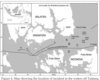
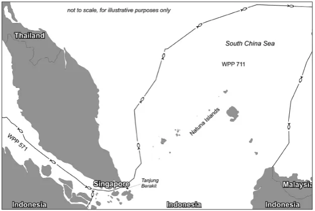
in the waters off Tanjung Berakit (MMAF 2010; MoFA 2010a) as illustrated by Figure 4.
The waters off Tanjung Berakit are located to the north of Indonesia’s Pulau Bintan, which in the international geographical naming convention is part of the Singapore Strait. The incident took place in the maritime area close to three small geographical features (islands/rocks): Pedra Branca, Middle Rock, and South Ledge as illustrated by Figure 4 (see also subsection 3.2). Malaysia and Singapore have disputed these three features for around 30 years until the dispute was decided by the International Court of Justice on 23 May 2008 (International Court of Justice 2008). The shortest distance between Indonesia (Pulau Bintan) and Malaysia (Johor) in the area is less than 24 M so that the maritime area between the two is territorial sea.15 Considering that Indonesia,
Malaysia, and Singapore have ratified the LOSC,16 the three States are entitled
to a 12-M territorial sea measured from their respective baselines/coastlines. Since the distance and maritime space available is limited, it is impossible for the three States to claim a full 12-M territorial sea without having overlapping
15 The distance was measured on a British Admiralty Chart (BAC) Number 3831. 16 Indonesia was first to ratify the LOSC in 1985 by Law UU No. 17/1985 followed by
claims. Accordingly, the maritime delimitation for the territorial sea among the three neighbouring States is inevitable.
3.2 The absence of maritime boundaries and existing
unilateral claims
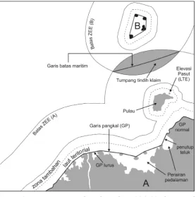
Indonesia and Malaysia have yet to agree on maritime boundaries (territorial sea) around Tanjung Berakit. One of the reasons is the long-standing three decades old dispute between Malaysia and Singapore regarding the sovereignty over three geographical features that is still pending maritime delimitation. They both claim sovereignty over three features Pedra Branca (Batu Puteh), Middle Rock, and South Ledge as illustrated by Figure 4 (International Court of Justice 2008). Maritime entitlement cannot be decided when the sovereignty over these three features remains uncertain. The dispute was brought before the ICJ and was decided on 23 May 2008 (International Court of Justice 2008). The court decided that Pedra Branca is awarded to Singapore and Malaysia
gains Middle Rock. Interestingly, the court did not specifically decide the
ownership of South Ledge and the decision merely declares that the low tide elevation (LTE)17 belongs to the State in the territorial waters of which it is
located (International Court of Justice 2008: paragraphs 299-300).
It is worth noting that even though no maritime boundaries have been agreed upon, Indonesia and Malaysia both have interest in the waters off
17 A low-tide elevation or LTE is a naturally formed area of land which is surrounded
by and above water at low tide but submerged at high tide (LOSC, Article 13 (1)).
Tanjung Berakit. This interest is, among other things, economically motivated
to explore and utilize maritime natural resources. In addition, both Indonesia
and Malaysia have made their own maritime claims (unilateral claims) in
the area although any final agreement is yet to be reached. These unilateral
claims seemed to be the cause of the incidents on 13 August 2010. Indonesia’s unilateral maritime claim is depicted on an Indonesian Map issued in 2009. According to the MMAF’s press release on 15 August 2010, Indonesia bases its claim on the MMAF’s Regulation number 1 of 2009 on Fisheries Management Area or Wilayah Pengelolaan Perikanan (WPP) of the Republic of Indonesia (MMAF 2009, 2010). The regulation is visualized by a map showing WPP in eleven different locations/zones, pursuant to Article 1 (2) of the Ministry Regulation. Based on the descriptive information provided by MMAF and MoFA, it can be concluded that the incident took place in WPP-711, a zone of
fisheries management around the Singapore Strait extending northeastward
to the South China Sea. As illustrated by Figure 5, WPP-711 is an area within
a polygon represented by lines with fish symbols. The map was issued by the Indonesian Navy Hydro-Oceanographic Office (Dishidros 2009) and was officially published by MMAF in November 2009. Similarly, MoFA also
asserted that the incident took place in Indonesian waters, based on map No. 349 of 2009, which clearly depicts the Indonesian claims (MoFA 2010a).
On the other side, Malaysia also has its unilateral claim in the water area off Tanjung Berakit. As asserted by the Indonesian Minister of Foreign Affairs, Malaysia bases its claim on a map it calls Peta Baru 1979, issued in December 1979. The 1979 map visualizes the outer limits of Malaysia’s maritime claim,
which is reasonably excessive in nature, particularly for those in the Sulawesi
Figure 5. Part of WPP Map pursuant to MMAF’s Regulation number
Sea and the Singapore Strait. The map clearly includes most of the maritime area around Tanjung Berakit to be part of Malaysia’s territory. Indonesia, as the other States in the region, refuses to recognize the map and sent notes of protest notes to the Malaysian Government (Haller-Trost 1998). According to Haller-Trost (1998), Indonesia sent the protest note in February 1980 in relation to the fact that Pulau Sipadan and Pulau Ligitan were also included on the map as part of Malaysian territory, while the dispute over their sovereignty had not yet been settled. Protest notes were also sent by the Philippines and China in relation to the Spratly Islands. Singapore sent its protest note in April 1980 in relation to Pedra Branca that was included as part of Malaysia’s territory, the sovereignty over which was not yet decided at that time. Some other protest notes were also sent by Thailand, Vietnam, Taiwan, and United Kingdom on behalf of Brunei Darussalam. Simply put, the 1979 map is Malaysia’s unilateral map that is not recognized by its neighbours and the international community.
However, the 1979 map remains an official map of Malaysia even until the
present time (March 2011).
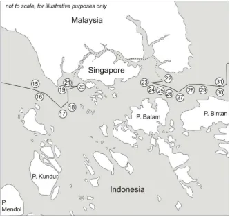
On the 1979 map, Malaysia’s claim in the maritime area around Tanjung Berakit is depicted by lines labeled with numbers in circles as illustrated by Figure 6. On the other hand, the Malaysian media reported that the Malaysian
fishermen the Indonesian officials captured were fishing in Malaysian waters.
An article in The Star Online (2010), for instance, asserted that the fishermen were in the waters off Middle Rocks, which apparently under Malaysian’s domestic law is part of Malaysian territory.
The Indonesian Ministry of Foreign Affairs, Marty Natalegawa, asserted
that both Indonesia and Malaysia base their justification of border crossings on their unilateral claims. It is worth noting that official statements in responding
to this kind of issue are usually highly diplomatic in nature. Sentences like “it is undisputable that the area is part of our territory” or “we have had indisputable sovereignty over the area since time immemorial” are usually
used in public statements. These expressions or statements are common in
order to strengthen each party’s position in diplomacy. For instance, in actual negotiations, those asserting statements serve as supporting evidence that a State is consistent and persistent with its unilateral claim. This, in turn, enables a State to maintain its position with strong arguments on the negotiating table. Ideally speaking, the management and the utilization of maritime natural resources can start after the establishment of maritime boundaries. In practice, it is not impossible for two or more States to agree on resources management
even before definitive border lines have been clearly defined, as long as the
arrangement does not prejudice future maritime delimitation (LOSC, Article
83 (3)). In addition, it is common that a State starts exploring/utilizing natural
resources in maritime area where maritime boundaries are pending, based on unilateral claims. This undoubtedly can build tension between neighbors and seems to be the case with Indonesia and Malaysia.
3.3 Geospatial analysis on the Tanjung Berakit incident
In finalizing this paper, the author used the geospatial and legal approach.Malaysia’s 1979 map and Indonesia’s 2009 map were used to analyse each party’s unilateral claims. Both of them were then combined to produce a new map showing the overlapping claims of the two States. The Indonesian 2009 map was overlaid with Malaysia’s 1979 map using the principles and functions in geographic information system (GIS)18 to generate a new map as
illustrated by Figure 7.19
18 Simply speaking, GIS refers to a computer-based technology for retrieving, storing,
and organizing data based on its location on a map. For further explanation on GIS, refer to, for example, Longley et al. (2001).
19 Technically speaking, the process involves geo-registration of coordinates and geodetic
datum unification into a widely used geodetic datum called WGS 1984 datum. Put simply,
geodetic datum is a reference from which measurements are made so that position can be
expressed in coordinates. It was then followed by overlaying process to identify overlapping
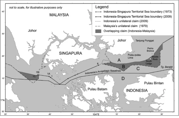
Figure 7 shows that Indonesia and Singapore have established territorial sea
boundaries that consist of two segments. The first segment is the line starting
from point 1 and ends at point 6, agreed by the two States in 1973.20 The second
segment starts at point 1 heading westward and ends at point 1C, agreed by
the two States on 10 March 2009 (MoFA 2009). Indonesia ratified the latest
agreement of 2009 through Law No. 4 of 2010, promulgated on 22 June 2010 (MoFA 2010b). Figure 7 also shows that Indonesia and Malaysia have yet to establish maritime boundaries between them for maritime areas to the east
of the existing Indonesia-Singapore boundary lines signed in 1973 and 2009.
As previously mentioned, Indonesia and Malaysia both made unilateral maritime claims in the waters off Tanjung Berakit. By combining Malaysia’s 1979 map and Indonesia’s 2009 map, an overlapping area was generated as represented by the shaded area enclosed by dashed lines in Figure 7. The
possible locations of the fishermen’s boat/vessel, according to this new
synthetic map, are in the areas labeled A, B, C, and D in Figure 7. The location
labeled A is safe and legal for Malaysia’s fishermen since it is within Malaysia’s
claim and is beyond what Indonesia claims on its 2009 map. Meanwhile, the
location labeled C and D are also safe and legal for Indonesia’s fishermen since
they fall within Indonesia’s claim and are beyond Malaysia’s claim.
If, for some reason, Malaysian fishermen enter area C or Indonesian fishermen enter area A, it may be considered an encroachment. Under a different scenario, infringement is more obvious if Malaysian fishermen come
20 The treaty and an analysis on it can be obtained from the US State Department.
Available from <http://www.state.gov/documents/organization/61500.pdf>.
to Indonesia’s archipelagic waters within the belt of Indonesia’s archipelagic
baselines (area D). Complications will arise when fishermen from either Malaysia or Indonesia enter area B. Indonesian fishermen entering into area
B will undoubtedly be considered an infringement by Malaysia’s patrolling
officials. Likewise, Indonesia’s patrolling officials will also declare that Malaysian fishermen have committed a border crossing if they enter area B. In
such a situation, clash and tension can be avoided if Indonesia and Malaysia implement a common standard operational procedure in the overlapping/ disputed area. This provisional agreement is important before the two States
agree upon final maritime delimitation.
3.4 Maritime boundary delimitation
Maritime delimitation to establish final and binding maritime boundaries
between Indonesia and Malaysia in the waters off Tanjung Berakit is an ideal approach to settle maritime disputes between the two States. Ideally speaking, the boundary line should be the prolongation or continuation (eastward) of the Indonesia-Singapore territorial sea boundary, starting at point 6 (see Figure 7). Accordingly, this delimitation process needs the involvement of not only Indonesia and Malaysia, but also Singapore. To deal with the particular area where maritime boundary segments among the three States potentially
converge, a trilateral meeting/negotiation is required. This is to define what
it is usually termed as a ”tri-junction point”. Having said this, even though at a particular moment in time Indonesia will be ready to negotiate, the process cannot proceed if one of its two neighbors (Malaysia or Singapore) is not yet ready or unwilling to do so. In line with this theory, Indonesia’s Minister of Foreign Affairs asserted that Indonesia was ready to negotiate at any time but Malaysia, at the time of speaking (August 2010), was not (MoFA 2010a). The process of maritime delimitation considers legal and geospatial/ technical aspects in its completion. Pursuant to LOSC, Article 15 of LOSC governs territorial sea boundary delimitation. The provision states that where “two States are opposite or adjacent to each other, neither of the two States
is entitled, failing agreement between them to the contrary, to extend its
territorial sea beyond the median line every point of which is equidistant from the nearest points on the baselines from which the breadth of the territorial seas of each of the two States is measured” (LOSC, Article 15). This implies that in territorial sea delimitation, the use of the equidistance line is preferred. However, this provision does not apply “where it is necessary by reason of historic title or other special circumstances to delimit the territorial seas of the two States in a way which is at variance therewith”. In other words, even though the use of the equidistance or median line is the preferred method in delimiting the territorial sea, there is a possibility to implement other methods for “historic title” and “other special circumstances” (LOSC, Article 15).
Two comprehensive analyses on maritime delimitation in the Singapore Strait involving Indonesia, Malaysia, and Singapore have been carried out
Sumaryo (2010) with attention given to legal and technical aspects. One important issue to consider in maritime delimitation is the sovereignty over South Ledge, which is currently uncertain. In addition, the impact that the three islands/rocks (namely Pedra Branca, Middle Rock, and South Ledge)
can have to the future maritime delimitation is also worth noting. The extent to which the three features affect the location of final boundary lines depends
on the effect/weight given to each of them. Meanwhile, the effect given to the three features depends on their status, whether they are considered islands or rocks, pursuant to Article 121 of LOSC or merely LTE which is governed by Article 13 of LOSC.
An island, according to LOSC, is an area of land, which is “naturally formed”, “surrounded by waters” and is always “above water at high tide” (LOSC, Article 121 (1)). An island that meets the aforementioned criteria is entitled to territorial sea, contiguous zone, EEZ, and continental shelf (LOSC, Article 121 (2)). Meanwhile, a rock that cannot sustain human habitation can only claim a 12 M territorial sea (LOSC, Article 121 (3)). A geographical object that is a naturally formed area of land, surrounded by and above water at low tide but submerged at high tide is called a LTE. It can only be used as part of baselines so that it can claim a 12 M territorial sea if it is located “wholly
or partly at a distance not exceeding the breadth of the territorial sea from
the mainland or an island” (LOSC, Article 13 (1)), or it has a lighthouse on it (LOSC, Article 7 (4)). This provision indicates how much technical aspects are
involved in the definition of islands, rocks, and LTE. In order to identify low and high tide, for example, tide observation involving hydro-oceanography is required. It requires the involvement of geospatial/mapping expertise to
identify whether a geographical feature can be regarded as an island, rock, or LTE. As asserted by Arsana and Sumaryo (2008), geodetic surveyors play an important role in ocean affairs and the law of the sea issues. With regard to Pedra Branca, Middle Rock, and South Ledge, these technical aspects need to
be taken into account to define whether the three features are islands, rocks, or merely LTEs. Their status is important, as it will affect the extent of the
maritime area they can claim in the Strait of Singapore, which in turn will affect maritime delimitation in the area.
and Singapore are well presented by Beckman and Schofield (2009) and Arsana, Yuniar, and Sumaryo (2010). There are several possibilities that the
States in question may consider by taking into account relevant factors. In addition to the ownership and status of the three geographical features, the use of different types of baselines is also worth considering. Indonesia, being an archipelagic State, can implement archipelagic baselines that theoretically, will enable Indonesia to gain more maritime space in the Singapore Strait.
With regard to the status of the features, it will not be surprising that Singapore may regard Pedra Branca as an island that is entitled to not only territorial sea but also EEZ and continental shelf. If the feature is considered an island, it may generate an EEZ triangle in the maritime area to the northeast
of Pedra Branca (see Beckman and Schofield 2009). However, Malaysia in this
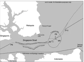
case may argue that the small feature does not constitute an island and is only entitled to territorial sea. Meanwhile, Indonesia may also argue that the three features should be given only nil effect in the delimitation process, considering that they are only small features that should not cause disproportionate effect in maritime delimitation, as stated by the ICJ in several of its decisions (Lowe, Carleton, and Ward 2002; Shi 2010). Figure 8 illustrates options of maritime delimitation in the Strait of Singapore (waters off Tanjung Berakit) by considering relevant factors such as the ownership and the status of Pedra
Branca, Middle Rock, and South Ledge. A more detailed explanation on the options is provided by Arsana, Yuniar, and Sumaryo (2010).
Figure 8. Maritime delimitation options in the Strait of Singapore (Arsana, Yuniar,
4 The way forward
While several maritime boundary disputes between Indonesia and Malaysia seem to be unrelated each other, they all have to be viewed as one big issue that is closely related to pending maritime boundaries delimitation between the two States. In other words, pending maritime boundaries between Indonesia and Malaysia is the root of many border problems between the two neighbours. It is worth noting that maritime boundaries are not only pending in the Sulawesi Sea (Ambalat) or the waters off Tanjung Berakit (Singapore Strait) but also in the Malacca Strait and the South China Sea. Even though every segment of the maritime boundary is unique, negotiation of one particular segment should not be viewed completely independent from that of other segments as a solution to one case/segment may indirectly affect the settlement
of other cases/segments. For example, an agreement/decision in giving full
or nil effect to a small island that affects one maritime boundary segment may be used as a reference in treating another small island in a different location.
As previously highlighted, maritime boundary delimitation can be settled through negotiation or submission to a third party. To date, Indonesia and Malaysia apparently opt for negotiation in settling their border disputes. Since
the first Ambalat Block issue sparked in 2005, Indonesia and Malaysia have
conducted at least seventeen technical-level negotiations, both in Malaysia
and in Indonesia. The sixteenth negotiation was conducted in Kuantan,
Malaysia where the two parties attempted to identify potential agreement compromising unilateral position/claim of both States (MoFA 2010c). According to Indonesia’s MoFA’s press release, the seventeenth would be conducted on 23-24 November 2010 the result of which would be available for public consumption early December 2010. However, for the purpose of this paper, the latest information regarding the seventeenth negotiation could not be obtained. Apart from the fact that Indonesia and Malaysia have been consistently making progress in maritime delimitation, it is worth noting that maritime delimitation is by no means an easy job (MoFA 2010a). The
negotiation with Malaysia started in the 1960s with the first agreement signed
in 1969 concerning seabed boundaries in the Malacca Strait and the South China Sea.
Another intriguing question in relation to border dispute settlement between Indonesia and Malaysia is whether the two States will bring the case before a third party such as ICJ or ITLOS. While an analysis and a prediction can be made, there is no guarantee that Indonesia and Malaysia will or will not bring the case before a third party. However, it is worth noting, as previously highlighted, that bringing the case to ICJ or ITLOS is one alternative apart from negotiation, mediation, and arbitration. There are several normative considerations when it comes to bringing the case before a third party, particularly ICJ. Firstly, bringing the case before ICJ will limit the
roles of parties in question and their control of the case can be significantly
documents prepared by both parties. Secondly, ICJ’s decision is final and
binding without opportunities to appeal (ICJ Statute, Article 60). This certainly has to be agreed upon by parties in question prior to bringing the case before ICJ. Thirdly, ICJ’s decision are often ”surprising” to parties in question since they are not in full control of the decision-making. The case concerning the Gulf of Fonseca involving Honduras, El Salvador, and Nicaragua (intervention)
is a good example in this regard. ICJ decided that a historical bay could be
divided among two or more States. In addition, ICJ also allowed Honduras,
to claim maritime zone in the Pacific Ocean (International Court of Justice
1992). Thirdly, even though this is debatable, dispute settlement through ICJ can be highly costly. The sovereignty case over Pulau Sipadan and Pulau Ligitan (International Court of Justice 2002), for instance, cost Indonesia
around IDR 16 billion as confirmed by the Indonesian former Foreign Minister,
Hassan Wirajuda (Tempo 2002). As to date, Indonesia and Malaysia have been showing consistency in opting to negotiation to pave the way toward maritime boundary settlement between them, instead of submitting the case to ICJ (Bernama 2009).
One positive impact of the Tanjung Berakit incident is that both States agree to accelerate the settlement of maritime boundaries between them (Indonesia National Portal 2010). The President of Indonesia, Susilo Bambang Yudhoyono
(SBY), responded to this incident by delivering a speech on 1 September
2010.21 Even though some opine that the response was relatively late, SBY
addressed the issue proportionally by acknowledging relevant technical and legal aspects to the case. He rightfully described the case in a legal and
technical framework as well as in the context of international relations between
Indonesia and Malaysia. However, as opined by several parties, the speech did not seem adequately to represent the feeling of the Indonesian people in general. Laymen’s limited knowledge of international law and the maritime delimitation principle has been one of the contributing factors to the tensions
that were building in Indonesia. It seems that SBY opted to put legal and technical aspects first, even though, consequently, he sacrificed his popularity in his response to the case. In his speech, SBY also specifically mentioned that
he encouraged that negotiations between Indonesia and Malaysia to settle the maritime boundary be accelerated and completed.
Following Spy’s speech, negotiations were carried out by the two States where the Ministers of Foreign Affairs of both States served as chief of delegation. The negotiations were held on 6 September 2010 in Kota Kinabalu, Malaysia (MoFA 2010d). Even though much hope and pressure were put on the negotiations, it was not surprising that they could not solve the problem in
the first instance. It is worth noting that no maritime boundaries can be settled in only one short meeting. However, considering the complexity of the issue,
the meeting may be considered as having been reasonably successful since the
21 The full text of SBY’s speech (in Indonesian) can be obtained from the President’s official
website. Available from <http://www.presidensby.info/index.php/pidato/2010/09/01/1473.
two States managed to agree to accelerate the process by conducting a series of negotiations in October and November 2010 as previously highlighted. As noted in a press conference in Jakarta by Indonesia’s foreign minister, Marty Natalegawa, maritime boundary negotiation can be a lengthy process. The seabed boundary between Indonesia and Vietnam was negotiated for around 30 years before it was agreed in 2003. However, some other negotiations took relatively less time to accomplish. Negotiations between Indonesia and Singapore for the western segment of their territorial sea boundary were
finalized in five years (MoFA 2010a).22
Like other boundary disputes, the solution to the case involving Indonesia and Malaysia cannot be easily predicted. Having advantages and disadvantages, bilateral negotiation seems to be the most preferable way
for Indonesia and Malaysia. In a negotiation, all parties are free to express
their claims and arguments and to take full control of the process toward reaching a decision. However, it is worth noting that the main characteristic of negotiation is that each party wants something and at that in the end none of the parties will gain everything they want. In fact, each party will gain less than what they want/propose. This is what negotiation is all about. However, this is apparently preferable than the possibility that one party may not gain anything, while the other party gains everything it proposes which is what may happen if a case is brought before a court or a tribunal.
Beyond the delimitation process, boundary administration and management is important in the future for Indonesia and its neighbours. As previously mentioned, maritime boundary lines are imaginary or virtual in nature so that the possibility of boundary infringement is relatively higher than in the case of land boundaries. Accordingly, a proper understanding of coordinates and positioning principles and the utilization of navigation aids such as maps and Global Navigation Satellite Systems (GNSS) like Global Positioning System (GPS) are essential for those who deal with maritime boundary issues. This knowledge is not only important for government
officials, but also for those who spend most of their time in border areas such as fishermen and sailors. Intimate and integrated collaboration among
stakeholders is inevitable to pave the way toward the establishment and maintenance of the virtual fences between States.
5 Concluding remarks
Pending maritime boundary delimitation between Indonesia and Malaysia in several locations is one of the reasons of tension building between the two
neighbouring countries. Indonesia and Malaysia have yet to finalize maritime
boundary delimitation in four locations: namely, the Malacca Strait, the South China Sea, the Sulawesi Sea, and the Singapore Strait. Pending maritime boundaries in the Singapore Strait seems to have been the main reason for the Tanjung Berakit incident on 13 August 2010.
22 For Minister Marty Natalegawa’s more detailed explanation, listen to the recorded
The Tanjung Berakit incident involved the apprehension of Malaysian
fisheries and Indonesian officials around the waters off Tanjung Berakit,
the sovereignty over which is currently uncertain. However, Indonesia and Malaysia have their own unilateral maritime claims in the area which and there
are therefore areas on which both States extend their claim. Consequently,
there is no consensus about the boundary line in the area and each State has its own version of the boundary line based on its own unilateral claim. Law enforcement through sea patrol and similar activities conducted by both States were based only on unilateral claims, not on an agreements or
regulations agreed upon by both States. Indonesian officials view the presence
of Malaysians in an area of overlapping claim as an infringement and so do
Malaysian officials in case of Indonesian presence in the same area. A geospatial
analysis of the maps of Indonesia and Malaysia’s unilateral maritime claims shows that there are several options and scenarios of infringement committed by one party against the other.
The key to resolving the Tanjung Berakit incident is maritime boundary delimitation between Indonesia and Malaysia in the Strait of Singapore. This is being undertaken by both parties through a series of bilateral negotiations. Ideally speaking, maritime boundary delimitation is based on the principles governed by the LOSC and relevant jurisprudences with proportional attention given to relevant, such as geographic factors (length of relevant coastlines/ baselines, the presence of small islands/rocks and LTE). In addition, current
and existing activities Indonesia and Malaysia have conducted for generations
in the area should also be taken into consideration.
A series of negotiations between Indonesia concerning maritime
delimitation have been progressing. Indonesian experts and officials led by
the Ministry of Foreign Affairs and supported by technical agencies such as National Coordinating Agency for Surveys and Mapping (Bakosurtanal) and Dishidros, are involved in facilitating these negotiations. There is no denying that the public may not be well informed of the progress they have
been making since there is substantial confidentiality. It is worth noting that
the public may not always be able to obtain the most updated and actual information about maritime boundary delimitation between Indonesia and its neighbours. Disproportionate reactions from the public and inaccurate information provided by media (newspapers, electronic media, etcetera) regarding border disputes indicate that the communication process between the government and the public needs to be improved. It is a challenge for
the government to find a balance between providing as much information as possible to the public while securing confidential information in order to
maintain good relations during the ongoing negotiation process.
Indonesia is the largest archipelagic State in the world and two third of its area is ocean. Indonesia views its area as an integrated unity of land territory and maritime jurisdiction. Due to its geographical position, Indonesia has ten neighbours to deal with, so that maritime delimitation should always be
academics (researchers, lecturers, students, scholars) should be able to play strategic roles through critical studies and quality publications. In order to balance information news media provide, which are sometimes provocative
and biased, academics should publish articles that based on scientific and
legal analysis. The availability of improved information derived from many different sources will enable the public to understand more comprehensively and respond more accurately to border dispute cases. All relevant stakeholders need to collaborate in building and maintaining the virtual wall between Indonesia and its neighbours.
Abbreviations
BAC : British Admiralty Chart
Bakosurtanal : Badan Koordinasi Survei dan Pemetaan Nasional/National Coordinating Agency for Surveys and Mapping
CLCS : United Nations Commission on the Limits of the Continental Shelf
ECS : ”Outer” or ”Extended” Continental Shelf EEZ : Exclusive Economic Zone
GIS : Geographic Information System GNSS : Global Navigation Satellite Systems GPS : Global Positioning System
ICJ : International Court of Justice
ITLOS : International Tribunal for the Law of the Sea JCBC : Joint Commission for Bilateral Cooperation
LTE : Low Tide Elevation
LOSC : Law of the Sea Convention
MMAF : Indonesian Ministry of Marine Affairs and Fisheries MoFA : Indonesian Minister of Foreign Affairs
RMP : Royal Malaysia Police
SBY : Susilo Bambang Yudhoyono
UN : United Nations
UNCLOS : United Nations Conference on the Law of the Sea WPP : Wilayah Pengelolaan Perikanan
References
Arsana, I Made Andi. 2007a. The delineation of Indonesia’s outer limits of
its extended continental shelf and preparation for its submission: status
and problems. [United Nations-Nippon Foundation of Japan Fellowship Paper.]
Arsana, I Made Andi. 2007b. Batas maritim antarnegara; Sebuah tinjauan teknis dan yuridis. Yogyakarta: Gadjah Mada University Press.
Arsana, I Made Andi and Clive H. Schofield. 2009. “Extending Indonesia? Opportunities and challenges related to the definition of Indonesia’s extended continental shelf rights”, in: Robert Cribb and Michele Ford
(eds), Indonesia beyond the water’s edge; Managing an archipelagic state, pp. 70-93. Singapore: ISEAS.
Arsana, I Made Andi and Sumaryo. 2008. “Aspek geospasial batas maritim internasional Indonesia dalam pengelolaan wilayah perbatasan”. Paper, Seminar dan Workshop “Pengelolaan Wilayah Perbatasan” Jurusan Ilmu Hubungan Internasional, Universitas Pembangunan Nasional “Veteran”,
Yogyakarta, 18-19 November.
Arsana, I Made Andi, F. Yuniar, and Sumaryo. 2010. “Geospatial aspects
of maritime boundary delimitation in the Singapore Strait involving Indonesia, Malaysia, and Singapore”, Proceeding of the IV FIG International Congress - Facing the Challenges, Building the Capacity, Sydney, 11-16 April,
accessed from <http://www.fig.net/pub/fig2010/papers/ts01i/ts01i_
arsana_yuniar_3939.pdf> on 15 March 2011.
Beckman, Robert and Clive H. Schofield. 2009. “Moving beyond disputes
over island sovereignty; ICJ decision sets stage for maritime boundary delimitation in the Singapore Strait”, Ocean Development and International Law 40: 1-35.
Bernama. 2009. “Ambalat case may not be brought to International Court”, accessed from < http://www.bernama.com/bernama/v5/newsgeneral.
php?id=415208> on 11 September 2009.
Carleton, Chris and Clive H. Schofield. 2001. “Developments in the technical
determination of maritime space; Charts, datums, baselines, maritime
zones and limits, maritime briefing”, International Boundaries Research Unit Vol. 3 No. 3. Durham, United Kingdom.
Claussen, Kathleen. 2009. “Invisible borders; Mapping out virtual law?”,
Denver Journal of International Law and Policy 37: 2.
Davenport, Frances Gardiner (ed.). 1917. European treaties bearing on the history of the United States and its dependencies to 1648. Washington, D.C.: Carnegie Institution of Washington.
Dishidros. 2009. Map of fisheries management area of the Republic of Indonesia [in Indonesian]. Jakarta: MMAF.
Frost, Robert. 1917. North of Boston. New York: Henry Holt and Company. Haller-Trost, R. 1998. The contested maritime and territorial boundaries of Malaysia;
An International law perspective. Cambridge, MA: Kluwer Law International. [International Boundary Studies Series.]
Herriman, Max and Martin Tsamenyi. 1998. “The 1997 Australia-Indonesia
maritime boundary treaty A Secure Legal regime for offshore resource
development?”, Journal of Ocean Development and International Law 29: 361-396.
International Court of Justice. 1969. “North Sea continental shelf cases (Federal Republic of Germany/Denmark; Federal Republic of Germany/Netherlands), Judgement of 20 February 1969, The Hague, The Netherlands”, accessed from
<http://www.icj-cij.org/docket/files/52/5561.pdf> on 21 February 2011.
International Court of Justice. 1982. “Case concerning the continental shelf (Tunisia/Libyan Arab Jamahiriya), Judgement of 24 February 1982, The Hague, The Netherlands”, accessed from <http://www.icj-cij.org/docket/
files/63/ 6267.pdf> on 22 February 2011.
International Court of Justice. 1985. “Case concerning continental shelf (Libyan Arab Jamahiriya/Malta), Judgement of 3 June 1985, The Hague, The
Netherlands”, accessed from < http://www.icj-cij.org/docket/files/68/ 9573.
pdf> on 20 January 2011.
International Court of Justice. 1992. “Case concerning land, island and maritime frontier dispute (El Salvador/Honduras: Nicaragua intervening), Judgement of 11 September 1992, The Hague, The Netherlands”, accessed from <http://
www.icj-cij.org/docket/files/75/6671.pdf> on 15 February 2011.
International Court of Justice. 2001. “Case concerning maritime delimitation and territorial questions between Qatar and Bahrain, Merits, Judgement of 16 March 2001, The Hague, The Netherlands”, accessed from <http://www.
icj-cij.org/docket/files/87/7027.pdf> on 24 February 2011.
International Court of Justice. 2002. “Case concerning sovereignty over Pulau Ligitan and Pulau Sipadan (Indonesia/Malaysia), Judgement of 17 December 2002, The Hague, The Netherlands”, accessed from <http://www.icj-cij.org/
docket/files/102/7714.pdf> on 14 February 2011.
International Court of Justice. 2008. “Case concerning sovereignty over Pedra Branca/Pulau Batu Puteh, Middle Rocks and South Ledge (Malaysia/ Singapore), Judgement of 23 May 2008, The Hague, The Netherlands”,
accessed from <http://www.icj-cij.org/docket/files/130/ 14492.pdf> on 20
February 2011.
Koh, Tommy T.B. 1982. “A constitution for the oceans”, accessed from <http://
www.un. org/Depts/los/convention_agreements/texts/koh_english.pdf>
on 15 February 2011.
Linden, H. van der. 1916. “Alexander VI and the demarcation of the maritime and colonial domains of Spain and Portugal, 1493-1494”, The American Historical Review Vol. 22 No. 1 (October): 1-20.
Longley, Paul A., Michael F. Goodchild, David J. Maguire, and David W. Rhind. 2001. Geographic information systems and science. New York: John Wiley and Sons Ltd.
Lowe, V., C. Carleton, and C. Ward. 2002. “In the matter of East Timor’s maritime boundaries opinion”, accessed from <http://www.petrotimor. com/lglop. html> on 20 February 2011.
MMAF. 2009. “Peraturan Menteri Kelautan dan Perikanan Nomor 1 Tahun 2009”, accessed from <http://www.infohukum.dkp.go.id/produk.php?cmd=
MMAF. 2010. “Press release: 3 fisheries observers detained by Royal Malaysia Police [in Indonesian]”, accessed from <http://www.dkp.go.id/ archives/c/34/ 3221/3-pengawas-perikanan-ditahan-oleh-polisi-perairan-marine-police-diraja-malaysia> on 17 August 2010.
MoFA. 2009. “Penandatanganan perjanjian antara Republik Indonesia dan Republik Singapura tentang penetapan garis batas laut wilayah kedua negara di bagian barat Selat Singapura”, accessed from <http://www.deplu.go.id/_
layouts/mobile/PortalDetail-PressReleaseLike.asp?l=en&ItemId=c148acb8-88c6-4e24-9dd3-352ec9cd90c2> on 20 August 2010.
MoFA. 2010a. “Indonesia sent a diplomatic note conveying protest to Malaysia”,
accessed from <http://www.deplu.go.id/Lists/News/ DispForm.asp?ID= 3878&l=en> on 20 February 2011.
MoFA. 2010b. “Indonesia and Singapore exchange the instruments of ratification of the treaty relating to the delimitation of the territorial seas”, available at
http://www.deplu.go.id/manila/Pages/News.asp? IDP=3912&l=en.
MoFA. 2010c. “Siaran Pers No. 183/PR//2010/53: Perundingan tingkat teknis perbatasan maritim RI-Malaysia ke-16, Kuantan, Malaysia, 13-14 October 2010, accessed from <http://www.deplu.go.id/Pages/PressRelease.
asp?IDP=1011> on 15 November 2010.
MoFA. 2010d. “Joint Commission for Bilateral Cooperation (JCBC) Indonesia – Malaysia”, available from < http://www.deplu.go.id/kotakinabalu/Pages/
Embassies.asp?IDP=19&l=id>
Oegroseno, Arif Havas. 2009. “Indonesia’s maritime boundaries”, in: Robert Cribb and Michele Ford (eds), Indonesia beyond the water’s edge; Managing an archipelagic state, pp. 49-58. Singapore: ISEAS.
Papanicolopulu, Irini. 2007. “A note on maritime delimitation in a multizonal
context; The case of the Mediterranean”, Ocean Development and International Law 38: 381-398.
Prescott, Victor. 1997. “The completion of marine boundary delimitation between Australia and Indonesia”, Geopolitics Vol. 2 No. 2 (Autumn): 132–149.
Prescott, Victor and Clive Schofield. 2005. The maritime political boundaries of the world. Second Edition. The Hague: Martinus Nijhoff. [First edition 2004.] Presidential Proclamation No. 2667. 1945. Policy of the United States with
respect to the natural resources of the subsoil and sea bed of the Continental Shelf, Washington, 28 September 1945.
Schofield, Clive Howard and I Made Andi Arsana. 2010. “Imaginary islands?
Options to preserve maritime jurisdictional entitlements and provide
stable maritime limits in the face of coastal instability”. Paper, The Sixth Ablos Conference “Contentious Issues in UNCLOS – Surely Not?”,
Monaco, 25-28 October.
Schofield, Clive Howard, I Made Andi Arsana, and R. van de Poll. 2010. ”The outer continental shelf in the Asia-Pacific region; Progress and prospects”,