_____________________________________________________________________________
Coral Reef Protection in Quintana Roo, Mexico.
Intercoast #34
_____________________________________________________________________________
Bezaury, Juan and
Jennifer McCann
1999
Citation:
Narragansett, Rhode Island USA: Coastal Resources Center.InterCoast Network Newsletter,
Spring 1999
For more information contact: Pamela Rubinoff, Coastal Resources Center, Graduate School of
Oceanography, University of Rhode Island. 220 South Ferry Road, Narragansett, RI 02882
Telephone: 401.874.6224 Fax: 401.789.4670 Email: [email protected]
This five year project aims to conserve critical coastal resources in Mexico by building capacity of NGOs,
Universities, communities and other key public and private stakeholders to promote an integrated
approach to participatory coastal management and enhanced decision-making. This publication was made
possible through support provided by the U.S. Agency for International Development’s Office of
I N T E R N A T I O N A L N E W SL E T T E R O F C O A ST A L M A N A G E M E N T
N ar r agansett, Rhode Island, U .S.A. • # 31 • Spr ing, 1998
Highlights
3
Managing Tourism in East Africa
4
South Africa Launches Coastal Program
8
Resource Conservation in Malaysia
16
Urbanization in Denmark
22
Reports From The Field
Intercoast
Survey Results
Show Diverse
Readership
M
ore than 200 people worldwide responded to Intercoast‘s recent readershipsurvey, and the results reveal a truly global audience with diverse areas of interests in coastal resource management.
Readers from more than 50 countries, representing an array of cultures, knowledge and inter-ests, provided personal and pro-fessional profile information, fields of interests, and sugges-tions to improve the look and usefulness of Intercoast. Although the majority of those who responded hold a Ph. D.,
Intercoast appealed to many who
did not. Readers are employed as environmental consultants, uni-versity professors and lecturers, government employees, research scientists and employees of non-governmental organizations.
Those surveyed indicated that
Intercoast is a valuable tool that
can be used by some to develop national policies, create research projects, compare coastal man-agement strategies and interna-tional trends, network, and pre-pare seminars and workshops; while for others Intercoast serves
as a source for general insight. The more than 200 readers
(continued page 2)
Protecting the Maya Reef
Through Multi-National
Cooperation
By Juan Bezaury and
Jennifer McCann
O
n Earth Day, June 5, 1997, heads of state from Belize, Honduras, Guatemala and Mexico, united in Tulum, Mexico to show their commitment towards the protectionand wise use of their shared coastal habitats, especially the coral reef, by signing onto the Mesoamerican Caribbean Coral Reef Systems Initiative. All four countries under-stand that this rich and diverse ecosys-tem, second in size only to the Great Barrier Reef in Australia, is the bases for many of their industries including tourism and fisheries. Currently, land-based activities, including coastal development, have placed increased pressures causing, in many cases, destruction or irreversible damage.
The Mesoamerican Caribbean Coral Reef Systems Initiative provides a forum for all four nations to act and
manage their coastal resources region-ally. The overall goal is to take advan-tage of growing opportunities for sus-tainable development, through the rational use and conservation of reef resources. Involvement and support by coastal communities, private compa-nies, national and international non-profit organizations and government
officials is crucial to the success of this regional and integrated initia-tive. Some of the objectives include the establishment of protected areas; strengthen-ing regulations; ecotourism plan-ning; securing international funding; and encouraging coastal man-agement to address the need for the sustainable use and conservation of this area. Providing opportunities for train-ing, scientific research and monitoring are also encouraged.
O ther agreements have been signed by these four nations, includ-ing the Tuxtla I and II Agreements; Agreements of the Central American Commission on Environmental and Development that encourage conserva-tion acconserva-tions on the Mesoamerican Biological Corridor; and the Cartagena Agreement on the protection and use of marine life in the Greater Fisher in Quintana Roo, Mexico.
that replied indicated that, on average, four other people read each issue.
Intercoast’s audience is even wider as
a result of readers contributing their copies to libraries, after making the rounds among coastal managers. This is in addition to those sent directly to libraries.
Intercoast readers suggested many
topics for future issues, including marine environment restoration; envi-ronmental techniques and methodolo-gies; geographic information systems
(GIS) and remote sensing; effects of climate change; aquaculture and fish-eries; water pollution; environmental law and policy; integrated coastal man-agement case studies; among others. W hether the readers of Intercoast are
from Algeria, Germany, or Tokyo, they all shared the common desire to learn about and understand coastal issues.
Survey respondents rated the fea-ture articles the most valued element of the newsletter, with “Reports from the Field,” “Intercoast Insider
Information” and the editorials follow-ing close behind. Intercoast’s editors
will use the survey results to tailor the
newsletter to what readers want to see and what is most relevant and benefi-cial to their work. Intercoast strives to
keep the articles and networking infor-mation topical and up-to-date.
Readers’ suggestions on how to improve Intercoast are useful and
appreciated, and the editors urge you to continue giving feedback, even in addition to the survey. Those who responded to the survey have already taken the first step to help shape the publication. We welcome your future involvement with Intercoast through
the contribution of articles and by offering your valued opinions.
Survey
(continued from page 1)
Intercoast to Begin Subscription Fee in 1999
In the past two years, Intercoast has expanded both its size and its global readership. Due to the costs
associated with printing and mailing, the expense of getting Intercoast to our increasing readership has risen.
O ne purpose of the recent Intercoast survey was to determine the willingness of our readers to pay a nominal
annual subscription fee to offset these growing costs.
The response we received was that, on average, Intercoast readers would be willing to pay a subscription
price of US$ 10 for three annual issues with a featured topic of interest; and periodically a special edition which would be devoted to a single topic, such as last year’s very popular Intercoast Special Edition # 1 on
mangroves. Based upon the survey response, beginning with the January 1999 issue, subscribers to Intercoast
will be asked to pay an annual fee of $10.
Some respondents raised concerns about charging a subscription price. These included the issue of costly international exchange rates, the desire to use credit cards rather than money orders and, most significantly, the inability of some individuals and organizations to pay a $10 annual fee. In regard to the first two concerns, we will develop systems for payment which minimize extraneous costs and complications. As for the last con-cern, we will provide the opportunity for individuals and organizations from developing countries who wish to continue to receive Intercoast for free if the subscription rate is a financial hardship.
Instructions for submitting payment or requesting a waiver will be published in the Fall edition of
Intercoast. We greatly value our audience and would not like to lose even one reader. We will try to accom-modate you and make the transition easy and equitable. Thank you for your continuing interest in and support of Intercoast.
By Friederike Ziegler
M
anaged tourism can often con-tribute to the survival of local communities. This was discussed during the workshop “Experiences in Local and Community Integrated Coastal Management (ICM) Projects – Lessons to Date” held in Zanzibar, Tanzania, March 4-6, 1998. The workshop was organized by the Secretariat for Eastern African Coastal Area Management (SEACAM, see Intercoast Network # 30) and the Western Indian O cean Marine Science Association (W IO M-SA). Fifteen local, community-based ICM projects from the East African region presented their results achieved and lessons learned. Some 70 partici-pants agreed that tourism, if contribut-ing to community development and respectful of local traditions, is a rea-sonable means of supporting long-term development and increasing com-munity awareness of the coastal area. Two experiences, one good and one bad, are described here.Bazaruto Archipelago –
Learning From Mistakes
Bazaruto is located 20 km off the south coast of Mozambique, about 800 km north of Maputo. The archipelago has 2, 700 inhabitants of which most are dependent on fisheries. Three of the islands constitute Mozambique’s only marine national park established in 1971.
The Bazaruto Project was established in 1989 to implement ICM. O ne initia-tive is to establish sustainable tourism that also benefits the local community. From the start, a major problem has been the lack of a legal mechanism to ensure that tourism revenues were returned to the local community. However, last year an informal agree-ment was reached between island tour operators, the national park and the Bazaruto project; now US$ 5 is
col-lected from each tourist entering the park. To date, about US$ 10,000 has been collected, representing some 2, 000 visitors. The money has been used to build schools, a health clinic and provide other community services. Also, this money funds two full-time educators who patrol the beaches, answer tourists’ questions, burn litter, and monitor for illegal fishing and destructive fishing methods.
Tourism still cannot be called sustain-able. A big problem is that cruise ships carrying 200-400 passengers visit the island, debark for shopping, snorkeling and diving (often creating environmen-tal problems) without contributing to the tourist fund. The number of ships has increased dramatically over the last year. Another problem is that neither the tour operators or the project em-ploys many local people, mainly because locals lack higher education.
To benefit the local community it is necessary for the tourism industry to contribute to the island community; to consult with the community before granting tourism concessions (to avoid conflicts of interests); and to market the marine park and its ecological diversity.
Misali Island in the
Zanzibar Archipelago,
Tanzania – A Successful
Venture
A tourism project started on Misali Island, Zanzibar, as part of the already existing Misali Island Conservation Project, begun in 1996. Misali is a small island with an area of 0.9 sq km. It is covered with forest and surround-ed by relatively undisturbsurround-ed mangroves and coral reefs. The World Tourism O rganization recommended that Misali become a nature conservation area, and the introduction of low-impact tourism be evaluated. A small-scale pilot pro-ject was started in December 1997. The project emphasizes that the local community should participate in and
benefit from the project. So far, four Misali fishers have been trained as tour guides. A tour operator in Zanzibar Stone Town takes tourists by high-speed
ferry to Pemba Island, where they stay and make day trips to Misali. Tourists give a voluntary US$ 10 donation that is spent on the local fishers and their families.
Conflicts between the fishers and conservation interests have not arisen on Misali, since the guides are also fishers and the conservation efforts have led to increased fish catches. Rather, the fishers are very enthusias-tic about the project and want to establish a nongovernmental conserva-tion organizaconserva-tion.
Misali, because of its small size, represents a manageable and realistic model for development of an ICM strategy which includes conservation, community development and tourism. However, larger efforts are required to conserve marine resources on a regional level.
For further information contact: SEACAM, 874 Av. Amlcar Cabral, Maputo, Mozambique. Tel: 258-1-300641/ 2. FAX: 258-1-300638. E-mail: [email protected].
Small-Scale Tourism in Eastern Africa:
Helpful or Harmful to Local Communities?
T
he South African coast stretches for some 3, 200 km between Namibia and Mozambique. It is the meeting place of the Atlantic, Southern and Indian oceans. People are attracted to this coast because of the many dif-ferent opportunities it offers through its rich natural resources, beauty andeconomic potential. The history of racially exclusive political and economic development has meant that indigenous populations have had limited access to the coast and its resources.
The growing demands of more and more people concentrated in coastal towns and cities have resulted in overuse, damage and destruction of some coastal resources. The Ministry of Environmental Affairs and Tourism has initiated a Coastal Management Policy Programme to prepare a policy that will guide the management of the coast for the benefit of current and future generations of all South Africans.
South Africa’s Coast
The South African coast is diverse. The biophysical features range from desert conditions in the northwest to tropical conditions in the northeast. Compared with many other coastal countries, South Africa has few large rivers, due to relatively low seasonal rainfall, and few sheltered bays. For much of the year, strong winds and stormy seas are experienced along this high-energy coastline, moving large amounts of sediment northward along the west and east coasts.Socioeconomic conditions also vary greatly, from isolated and poor subsis-tence farming to the urbane and sophis-ticated activities associated with mod-ern cities, notably in Cape Town, Por t Elizabeth, East London and Durban. This diversity is reflected in the range of activities that take place at the coast, including commercial farming activi-ties; residential, recreational and resort developments; port activities; marina developments; mining; fishing; nature reserves; and transport infrastructure, among others. There are a variety of cultures and languages, with four of the country’s eleven official languages being spoken along the coast, namely Afrikaans, English, Xhosa and Zulu.
Institutional characteristics and capaci-ty also vary along the coast. W hile a single national constitution applies along the coast, there is a marked variation in local and regional government struc-tures, with the incorporation of tradi-tional leadership structures being a sig-nificant feature of administration in some regions.
History and Structure
The election of South Africa’s first democratic government in April 1994 has provided a fundamentally different context for public policy making. Now all South Africans can engage in a meaningful dialogue to address issues of common concern. It is in this con-text that the Coastal Management Policy Programme has been developedand implemented.
The program was born out of the need to redress the imbalances of past apartheid policies, and to address the problems inherent in an uncoordinated approach to coastal management. Ex-tensive negotiations with a broad spec-trum of national interest groups led to agreement on a process for formulat-ing the coastal management policy and the structures that should guide it.
Policy Committee: The Minister of Environmental Affairs and Tourism appointed a policy committee to make recommendations about a draft policy for managing the coast. The policy committee is a partnership between government and civil society, and rep-resents the interests of national gov-ernment, provincial govgov-ernment, business, labor, community-based organizations, environmental non-governmental organizations, and the sport and recreational sector. Each pol-icy committee member has equal sta-tus, and decisions are made by consen-sus. The policy committee has been constituted as a not-for-profit compa-ny to administer the program.
Project Management Team: A project management team has been appointed by the policy commit-tee to implement and manage the program. It is made up of individuals from the consulting firms of Common Ground Consulting and Watermeyer, Prestedge, Retief. It also includes individuals with skills and expertise in coastal management, general project and process management, facilitation and public participation, and commu-nications.
Regional Managers: A group of five regional managers has been appointed to facilitate the involvement of interested and affected parties around the coast, and to consolidate information relevant to their regions.
Funding: The British Department for International Development has generously provided the financial support for this program.
South Africa Launches Coastal Management
Program
allel program of interaction with gov-ernmental actors has been implemented to ensure that national and provincial levels of government are fully informed and involved in the process.
Specialist studies: Four specialized investigations to inform the policy for-mulation process have been initiated.
They include:
• Related initiatives currently underway • Characterization and assessment of coastal regions and resources
• Lessons learned from past experience • Legal and institutional context and capacity
Conclusion
The Coastal Management Policy Pro-gramme marks a fundamentally new approach to coastal management in South Africa. Central to this approach is building new partnerships within and between government, civil society and the private sector. Through these part-nerships the program hopes to develop an integrated approach to coastal man-agement based on a practical policy that addresses key coastal issues and realizes a common vision for the South African coast.
For further information on this pro-gram, please refer to the following website: http:/ / www.cmpp.co.za.
Program Aims
The coastal management program aims to achieve the following:
Meaningful public participa-tion: The program wants to ensure that all interested and affected parties will have the opportunity to participate in all stages of the policy formulation pro-cess. Participation is necessary to make sure that the policy addresses real issues of concern, is based on a common vision for the future of the coast, leads to broad ownership of and commitment to the policy, and results in its effective implementation. Government support and active participation is therefore vital, as is broad public participation.
Scientific integrity: The policy must build on the knowledge and understanding of coastal systems and resources. Scientific research also needs to be integrated with sources of tradi-tional and common knowledge, and with the information generated through the public participation process of the program. O nce the policy has been formulated, there will be a need for ongoing, integrated scientific research.
Integrated coastal manage-ment: Coastal management is a process that ultimately requires creative part-nerships to be established between government, civil society and the pri-vate sector. Such partnerships should aim to promote a scientifically rigorous, but inclusive management approach that will improve the quality of life of coastal communities, and those who depend on, use and enjoy the coast. The approach should also maintain the bio-logical diversity, productivity and eco-logical integrity of coastal ecosystems.
Practical policy: This policy will only be effective if it results in better management of the coast. The policy must therefore be practical and address priority and strategic coastal issues. Coastal management is best thought of as a process – it is not a one-time activity. This process involves policy formulation, implementation, monitor-ing and evaluatmonitor-ing the results, and, where appropriate, making revisions to both the policy and implementation
measures to ensure that the desired outcome is achieved. The process of policy formulation must therefore include opportunities to learn from and adapt to direct experience and to that gained by others. The policy for-mulation process must also strive to promote partnerships that will help the policy to be implemented. O nly in this way will an effective policy be developed.
Program Components
Integration and analysis of in-formation: The project management team is integrating and analyzing information from a range of sources including information generated in the course of the public participation process, related initiatives currently underway in South Africa and past research, among others.Capacity building: This aspect of the program seeks to address the unequal access to resources, education, knowledge and power experienced by dif-ferent groups within South Africa. The focus of this activity is to enhance the capacity of people to participate in the poli-cy formulation process. Approx-imately 30 percent of the project budget is devoted to this end. It should be noted that it is not only disadvantaged groups who need capacity building. A recurrent theme in processes with a strong emphasis on public participation is the relative distance between specialist profession-als and lay people.
Communications: The communi-cations program includes activities at the national and regional level to pro-vide information about the program and encourage the involvement of interested and affected parties. It includes media coverage, the preparation of pamphlets, posters and booklets written in plain language, as well as the production of a website dedicated to the program and an introductory video.
par-By Alan T. White,
Virginia Barker and
Gunatilake Tantrigama
H
ikkaduwa and its marine sanctu-ary are representative of the is-sues facing many coastal areas in tropical Asia where tourism and coastal devel-opment have nearly ruined valuable coastal resources. For Sri Lanka, the Hikkaduwa Marine Sanctuary is theonly accessible coral reef on the south coast. The 4-km coastal strip (about 100 hectares) is known for its coral reef, clean water and beaches. Tourists continue to come despite increasing environmental degradation, primarily because the damage is not obvious to new visitors. However, tourists are beginning to recognize the problems and threaten to go elsewhere.
Integrated coastal management (ICM) and the investment in environ-mental management to prevent degra-dation and loss of biodiversity are the key issue in Hikkaduwa. The question is whether or not the tourism industry, the town and the national government can economically justify the rehabilita-tion and conservarehabilita-tion of the coastal environment of Hikkaduwa. The con-clusion is that the program proposed
here, if carried out for more that five years with any level of tourism growth equal to or exceeding 3 percent, is financially beneficial.
Coastal Management
in Sri Lanka
Sri Lanka's national coastal zone management program, established in 1990, allows development within a
coastal strip 300 meters wide on land and 2 km out to sea, while preventing unnecessary environmental degradation, pollution and erosion.
In 1992 Hikkaduwa was selected as one of two
Special Area Management (SAM) sites under the Coast Conservation Department and the Coastal Resources Management Project of the University of Rhode Island’s (USA) Coastal Resources Center and the United
States Agency for International Development. A cost-benefit analysis of the tourist industry and key coastal resources was done to justifying man-aging the coastal resources which sup-port tourism. Economic scenarios that assume different levels of tourism were used to portray the potential future economic benefits from improved environmental management.
Management Issues and
SAM Plan Objectives
Tourism in Hikkaduwa has declined in recent years. The reason is unplanned and uncoordinated development causing degradation of the coral reef, declining water quality, sedimentation, inade-quate solid waste disposal and coastal erosion, among others. In addition, coral mining, a socioeconomic and environmental problem, continues near the Hikkaduwa Marine Sanctuary.
The overall goal of the SAM plan is to protect and manage coastal resources so the community can bene-fit from a healthy environment, and the local tourism and fishing econo-my can remain sustainable. Benefits from resource management include protection of the coral reef and regula-tion of activities within the marine sanctuary; maintenance of water qual-ity and control of waste disposal;
Using ICM and Economics to Conserve Coastal
Tourism Resources in Sri Lanka
Figure 2: Cumulative socio economic NPV for 9, 6 and 3 percent tourism growth.
control of shoreline development; and more nature-based tourism development.
Economic Evaluation of
Hikkaduwa’s SAM Plan
For the SAM plan to merit imple-mentation, it must be competitive with other development and conservation projects and contribute to the economic benefits of Hikkaduwa’s tourism econ-omy. Management costs reflect past poor planning, infrastructure and en-forcement. These threaten the marine habitats crucial to the tourism indus-try. The SAM plan resolves competing demands on area resources by planning for optimal and sustainable resource use. It addresses resource degradation as well as the social and economic impacts of tourism.
To determine the project lifetime, an appraisal should consider all years for which the project produces bene-fits or costs. For Hikkaduwa, since the project has been designed to prevent irreversible environmental degrada-tion, project benefits are expected to accrue into perpetuity. In the interest of predictable analysis results, benefits and costs of the project are only esti-mated over the first 20 years.
The economic analysis is based on four field surveys: 1) a survey of 168 Hikkaduwa business establishments and their revenues, costs and employ-ment; 2) a survey of 122 randomly selected foreign visitors to Hikkaduwa in 1993; 3) a survey of 96 foreign tourists’ willingness to pay for protec-tion of the beach and coral reef resources 1995; and 4) a survey to count reef users in 1995.
Financial Analysis and
SAM Plan Costs
The simplest form of economic evaluation for the SAM plan is the cash flow impacts of management options to direct project beneficiaries and contrib-utors. If the management plan is fully implemented by the direct beneficiaries of Hikkaduwa tourism, then this analy-sis evaluates the financial profitability of
the plan for the local tourism indus-try. Unlike the fixed nature its are depen-dent on visita-tion levels.
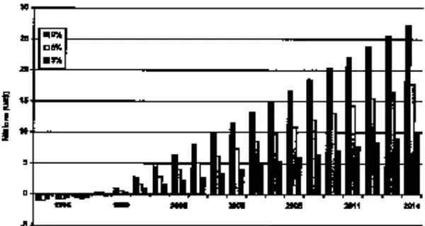
To account for the uncertainty of growth projections, three different rates of annual growth are used: an optimistic 9 percent increase, a mod-erate 6 percent, and a conservative 3 percent increase. Hikkaduwa guest night projections for 1995 to 2014, considering with and without plan implementation, are shown in Figure 1. W ithout plan implementation, the resources of interest to Hikkaduwa tourists are
“scrap values.” A positive FNPV indi-cates that the project is at least as prof-itable to the owners or stakeholders as the next best investment alternative. FNPV calculated over the 20-year life of the project reveals that the plan is financially viable.
Social and Environmental
Analyses of SAM Plan
Implementation
Social benefits to area residents due to SAM plan implementation include
solid waste management, sewage collection and treatment, improved roads and other public infrastructure, environmental education programs, vocational training and heightened law enforcement. The net present value (NPV) of quantifiable socioeconomic costs and benefits of implementing the SAM plan are estimated for the three visitation rates (Table 1). Calculation of cumulative net benefits indicates that for any project lifetime exceeding
four years, with any level of tourism growth equal to or exceeding 3 per-cent, the cumulative benefits exceed cumulative costs and the project pays for itself (Figure 2).
The financial analyses considered only the costs and benefits to the tour-ism industry within the Hikkaduwa SAM site, whereas the socioeconomic analysis included impacts on the entire economy of the management area and some aspects of the national economy.
Table 1. NPV of Benefits (US$ millions) From SAM Plan Implementation Derived From Various Economic Analyses
Growth Financial Socioeconomic Environmental Environmental
Scenario Economic Economics
(net profit (with less SAM cost) consumer surplus)
H igh (9%) 13.2 27.8 24.5 27.1
Medium (6%) 8.1 17.2 15.2 10.0
Low (3%) 4.6 9.8 8.7 2.2
Table 2. Absolute and Percentage Share of SAM Project Beneficiaries/Cost Burdens
Project Beneficiary/ NPV of Benefits Percentage Burden Holder (US$ millions) Share
Local tourism industry 8.86 72.5
International community 5.64 21.7
Local community 0.52 2.0
N ational economic welfare 0.98 3.8
SAM plan costs 3.47 72.6
Coral miners 1.31 27.4
By Donna J. Nickerson,
George Chong and
Kevin Hiew
I
n Malaysia, the Department of Fisheries (DO FM) established a sys-tem of marine parks to protect impor-tant marine resources including coral reefs, which contribute to biodiversity and fisheries production. Tourism has been a natural development of the marine parks and also one of the rea-sons for expanding the scope of marine park management.DO FM is establishing a Special Area Management Plan (SAMP) for Pulau Payar Marine Park and the surrounding area. The SAMP project is being imple-mented by DO FM in collabo-ration with the Bay of Bengal Programme of the Food and Agriculture O rganization (FAO ). The goal of the SAMP is to promote the conservation and sustained production and use of the area’s reef resources. Building on existing marine park man-agement, the SAMP will be used as a model for other marine park islands in Peninsular Malaysia and to develop a national integrated coastal manage-ment (ICM) framework.
Pulau Payar Marine Park, established originally as a Fisheries Protected Area in 1987, was the first marine park in Malaysia. Since then, marine waters surrounding 34 additional islands were gazetted as marine parks by DO FM. Prior to the SAMP, park management focused mainly on the environment within two nautical miles and on activ-ities directly associated with tourism. The SAMP expands on the progress made under the park management to now begin to address a wider scope of issues (and stakeholders) that affect the sustainability of the park.
The SAMP approach is incremental. The first phase was to form a working group to complete the groundwork needed to take the SAMP process to a
wider audience. The second phase was to characterize the geographic area under the SAMP to help identify and understand the issues and problems, their probable causes and the possible solutions. The third phase is developing solutions with input from a wider audience of local decisionmakers.
The Alor Star Workshop
The project held a workshop in Alor Star, Malaysia, in October 1997, that marked the transition between the sec-ond and third phase. The results of the scientific characterization activities under the second phase were presented to the SAMP participants. The work-shop enabled interactions between the state agencies, universities and non-governmental organizations that will participate in the SAMP.Participants were invited from 17 agencies and organizations. Topics included: 1) progress in the SAMP activities at the national level to pre-pare for the interagency state level SAMP development and implementa-tion work; 2) early results of the scien-tific characterization findings; and 3) participants’ recommendations on issues for management, probable caus-es of the issucaus-es and possible solutions.
Scientific
Characterization
Results
The study indicated that reef fish catch increased between 1986 to 1996 in the vicinity of the Pulau Payar Marine Park. This included landings of 10 coastal districts of Kedah State and 18 coastal districts of Langkawi Island. Fish catch of non-reef fish had declined during this same period. Further, the status and trends analysis compared catch of fishers that fished outside the vicinity of the marine park (i.e., greater than 25 nautical miles) to catch taken in the vicinity of the park (i.e., less than 25 nautical miles). Results indicated
that while catch near the park had been consistently higher during 1986-1994 than catch outside the park, catch taken near the park decreased during 1995-1996 relative to catch outside the park.
Findings of the coral reef habitat analysis indicated a similar decline in 1996. Live coral coverage between 1982 and 1994 at five sites were ana-lyzed; the same sites were again moni-tored in 1996. While coverage increased after the establishment of the marine park, coverage at the sites most heavily used by tourists (i.e., Jetty and Float) declined after 1994; declines were less at those sites less used by tourists and only visited by divers (i.e., Kaca).
A study of tourism trends and im-pacts revealed that divers caused little damage to the reef. However, snorkel-ers and swimmsnorkel-ers caused significant damage by trampling of corals. Park visitor numbers have increased from 1,373 in 1988 to over 91,000 in 1997. The number of visitors is monitored daily by the DO FM park rangers. Demographic trends analysis of Kedah State indicated that the coastal population in the study area has expe-rienced a 38 percent growth from 1970-1991. However, Kedah’s coastal districts have experienced a negative growth rate in the three sub-districts. This may reflect the high out-migra-tion rate of young family members from fishing as an occupation.
Thirty-one percent of fishers inter-viewed reported improvements in fish stocks, while 20 percent felt that fish stocks are worse off than 10 years ago. However, the majority agreed that government has taken adequate steps to conserve the fishery resources, but that stricter enforcement was needed, particularly on the number of boats in the fishery. The majority also were not satisfied with the current environmen-tal conditions along the coasenvironmen-tal areas of Kedah.
At the workshop, smaller working groups discussed SAMP issues: decline in the fishery resources (overfishing); impacts from tourism development; impacts from changes in land and sea-based development; and protection of marine biodiversity and ecosystem health.
A second workshop is being planned that will ensure greater participation from stakeholders who are direct users of the resources, such as fishers and tour/ dive operators. The workshop will be geared towards exchanging views with the wider public on the SAMP objectives and potential actions, and identifying and committing to the roles and responsibilities of all stakeholders.
Tourism in Pulau Payar
Marine Park
Economic revenue for the local area and for Malaysia as a whole is generated from the use of both land and marine resources. However, sustainable use and sustainable economic revenue re-quires a healthy ecosystem. For exam-ple, much of the land development in the coastal districts of Kedah and in Langkawi, including the Port of Langkawi and along the mainland, has been for tourism. Tourism, like fisheries, while a large revenue generator for the state, is dependent over the long term on a biologically diverse marine and coastal ecosystem.
Demographic trends indicated that the population in the Langkawi Islands is more stable than in the Kedah coastal districts. The stability of Langkawi’s population was explicitly linked to the development of Langkawi as a tourist area. The population has not needed to migrate outside the districts for em-ployment because of the economic opportunities offered by the tourism-associated industries. However, results also showed that maintaining the tour-ism industry also means maintaining the health of the marine park ecosys-tem. Pulau Payar is a main item in the tour itinerary to Langkawi. A survey indicated that tourists want a marine park with clean beaches, an abundance
of reef fish, diverse coral life, peace and quiet, friendly and helpful park staff, adequate facilities and adequate information on the marine environ-ment. More than half indicated that the opportunity to dive and snorkel was an important factor. The survey revealed dissatisfaction with the high number of visitors and lack of both guided activities and information on the marine environment. A large per-centage indicated that an increase in visitor numbers would affect their enjoyment of the park.
Results presented at the workshop
also indicated that unbalanced use of the area’s resources may also have an impact on fisheries resources and coral reef habitats. As stated earlier, while live coral coverage increased after the establishment of the marine park, live coverage at the sites most used by tourists declined after 1994 during years of heavy tourism. However, declines were less at sites more infre-quently used by tourists and only visit-ed by divers.
Results of the studies are not con-clusive, given the limited number of sampling periods and gaps in informa-tion. Rather, the results were viewed
as indicative of probable effects of the identified problems. Results strength-ened the fact that the local economy was dependent on the health of the marine park’s ecosystem.
Discussions at the workshop clearly concluded that both federal and state level participation would be equally important in achieving a balance between development and conserva-tion. The next step in the SAMP is to work out a formal mechanism for the long term where the federal and state levels of multiple agencies can contin-ue to understand the interlinkages of
their activities and coordinate solutions to ensure sustainability of the park’s resources.
For further information contact: George Chong, Head, Marine
Resources Branch, Department of Fisheries Malaysia, W isma Tani, Kuala Lumpur 50628, Malaysia. Tel: 603-298-2011. FAX: 603-291-0305. E-mail: [email protected]; or
Donna J. Nickerson, Coastal Management Officer, FAO Regional Office for Asia and the Pacific, Maliwan Mansion, Bangkok 10200, Thailand. FAX: 662-280-0445. E-mail: [email protected].
By Paul Geerders, Christiane
Klöditz and Orhan Uslu
A
ccurate and up-to-date knowl-edge of land use and land cover in the coastal area is a basic and essential element for planning and management activities. The term “land use” in this context relates to human activities or the economic function associated with an area (e.g., urban, industrial, agricul-tural, or recreational), while “land cover” specifies the type of feature pre-sent on the earth’s surface (e.g., forest, lake, or highway).Rapid urbanization and industrializa-tion of the world’s coasts, and resulting conflicts and problems, underline the global importance and vulnerability of coastal areas. There are many requests for the application of integrated coastal zone management (ICM) for improved planning and management of these areas. ICM implies managing coastal zones as complete systems, including the com-plex relations and interactions between different constituents and local com-munities. Sustainable development can only be achieved in this way.
The successful application of conven-tional aerial photographs to map land use and land cover has been recognized for decades. But recently digital photo-cameras have become a new and rapid-ly developing technology for aerial photography with several advantages over conventional photography. First, the images are immediately available in a computer-compatible format for quick inspection during the flight as well as for further digital processing immedi-ately afterwards. Digital images can be directly displayed, manipulated and processed using digital image processing techniques, including image enhance-ment, geographic information systems (GIS) and classification techniques. Furthermore, the output quality of digital photocameras is more reliable since there is no “developing” process
which introduces uncertainties. Applications include updating maps quickly, surveying remote areas, and doing frequent surveys, for instance, to identify illegal building and dumping activities.
During 1997, the Institute of Marine Sciences and Technology (IMST) of Dokuz Eylül University in Izmir, Turkey, in cooperation with its Dutch partners first started to use digital images in coastal zone management. A survey was done in January 1997 in Turkey, using similar means as used in 1996 on a Dutch test site. The first application was during the planning of a marina in southwestern Turkey. Encouraged by the good results, IMST carried out many more flights using digital photography over several areas along the Aegean coast. Parallel to this work, IMST fur-ther developed the technology and started to use digital video cameras to obtain continuous images from coastal areas. The use of video necessitated the development of software to snap indi-vidual frames out of the series of images; this complicated the processing as compared to digital photography. O n the other hand, shooting images from the airplane became fully automated.
Marine Construction
in Fethiye
Digital aerial photographs were taken from a locally hired plane along the southwestern coast of Turkey near Fethiye. This survey was conducted in conjunction with planned coastal con-struction related to the development of a marina. The images were taken from about 3-km altitude at predeter-mined positions. A small hand-held global positioning system (GPS) was used to check the position and course of the plane. Each position was marked in the GPS memory for later reference during processing.
Immediately after the flight, the dig-ital pictures were downloaded to a
computer and processed in two ways: 1) they were merged into mosaics using Photostyler and 2) they were converted to a GIS format using IDRISI (IDRISI is computer software with professional-level GIS, image processing and spatial statistics analytical capability). Piecing together the individual digital pho-tographs into one image (mosaic) resulted in a overview of the area. The GIS format allowed comparison to the 1978 map of the area and showed the up-to-date planned construction.
The advantages of using digital pho-tograph images were numerous:
■ The existing maps of the area did not show land use changes that resulted from rapid development of the area during the last 20 years. Changes relevant to planning the marina could be detected without new mapping efforts, with minimal cost and time expenditures.
■ The images that contained both land and sea areas were an ideal basis for the computer-aided design (CAD) of the marina and for visualization of the entire project for demonstration and presentation purposes.
■ The digital images contained a wealth of information able to be used as base-line data for the first steps of the envi-ronmental impact assessment for the marina.
■ For coastal engineering studies (e.g., design of wave breakers) the images were more reliable than existing maps.
■ The coast delineation was accurately depicted in the images which, combined with the bathymetric information, made it possible to determine dredge and fill quantities for the marina construction to the utmost satisfaction of the client. These quantities constituted one of the most important items in the overall cost estimates of the planned construction.
The Çesme Region
Çesme Peninsula is a rapidly devel-oping tourist resort area on the west coast of Turkey. Besides touristment, many second (summer) houses are being built. The local administra-tors have been overwhelmed by this development and are finding manage-ment difficult. To promote and dem-onstrate the potential of digital aerial photography/ video, IMST proposed to the municipality of Çesme to prepare a GIS, based on Landsat images and aeri-al photography. Landsat images and existing regional maps constituted the baseline of the planned system. Aerial digital images have been indexed to this baseline at subregions where additional detail was desired. Work started in late 1997 and numerous applications of the GIS have already been substantiated:
■ Areas that need a sewage system and water supply could be delineated with great accuracy. Population densi-ties (variable between summer and winter) could easily be assigned to these regions. The total wastewater collection and disposal system could be divided into self-sustained subregions that opti-mise the construction and operation of the whole system. The priorities and construction sequence of system com-ponents could be developed based on information extracted from the GIS.
■ In the semi-arid Mediterranean re-gion, treated wastewater can be used for irrigation purposes. In Çesme, dig-ital imagery could define possible irri-gation areas.
■ Aquaculture areas that cause environ-mental problems could be delineated by digital imagery. Illegal operations could be detected. For legally operating fish farms, remediation measures can be undertaken.
■ A new drinking water reservoir has been completed to supply the region. The digital images were invaluable to plan and manage the land use and to define protection measures in the catchment area of the reservoir.
■ The mayor of Çesme was very happy to show the new facilities to his colleag-ues from neighbouring municipalities. He could boast that his town was the most up-to-date among the municipal-ities on the western coast of Turkey.
Detection of Coastal
Erosion in the Altynova
Region
The Altynova region is famous for its sandy beaches south of Ayvalik on the northern Aegean coastline of Turkey. Construction of an irrigation dam up-stream of the Madra Creek resulted in sediment input to the beach region be-ing cut off. Consequently the sediment balance at the coast has been disturbed resulting in heavy erosion. O ver seven years, 50,000 sq meters of beach has been lost, and the coastline has receded by 200-250 m. The region’s harbour authority asked IMST whether the extent of beach erosion could accurate-ly be determined by digital imagery and whether beach protection measures could be proposed. IMST concluded that this could be achieved with high resolution digital images together with exiting maps and Landsat images.
Digital Images in
Environmental Impact
Assessment Studies
Environmental impact assessments (EIA) require detailed information on the present environmental conditions of the development area. Digital images/ videos have proven to be a very quick and inexpensive way to provide the geographic information at a scale that is appropriate for an EIA. Moreover, the images provide more information on recent land cover and land use than conventional maps. Specifically, it is possible to detect the extent and varia-tion of flora from the images that previ-ously required extensive reconnaissance surveys. Also, recent development of housing, roads, amoung others, can easily be determined. The digital imagery/ video has become an integral part of almost every impact assessment undertaken at the IMST.
Cost Effective and
Flexible
The use of digital aerial photography for monitoring and surveying is very cost effective. Digital cameras are rela-tively cheap and the ad hoc hire of a
small plane is generally not too expen-sive. Digital images require no special hardware to process, and good, inexpen-sive photo-processing software packages exist. In addition, packages such as IDRISI present additional options for processing, including precise rectifica-tion and classificarectifica-tion.
Digital aerial photography as described, forms a cost effective and flexible alternative to the traditional methods of monitoring and mapping coastal areas. The method is simple and straightforward, and can be implement-ed successfully with minimal investment. Digital aerial photography is a valuable tool in the development and imple-mentation of ICM models, especially
since digital land use maps can be manipulated by computer to allows the presentation of numerous alternative management options.
For further information contact: Paul Geerders, P. Geerders Consult-ancy, Kobaltpad 16, 3402 JL IJsselstein The Netherlands. Tel/ FAX: 31 30 6884942. E-mail: [email protected].
By Riyad Mistry
T
he Republic of Marshall Islands consists of 29 atolls and five large islands in the central Pacific O cean. There are 1,225 small islands and islets with a total area of 181 sq km. Bikini and Enewetak atolls were used for atomic weapons testing by the United States during the 1940-50s. Copra pro-duction, licensing agreements for fish-eries, aid through the Compact of Free Association with the United States and external assistance are the primary sources of revenue to the economy. Tourist attractions include underwater remains of World War II ships, Japanese war relics, coral reefs and sportfishing.Aquaculture of black pearl oysters and giant clams, and recovery of sand from offshore areas hold promise for eco-nomic development.
In 1988 the total population was 43,380, with an annual growth rate of 3.8 percent. Almost half the population lives on Majuro Atoll, the capital (five sq km), and 19 percent live on Ebeye Island in Kwajelein Atoll. Although the population may be low compared to other developing countries, the litany of symptoms associated with rapid urban-ization are evident on Majuro Atoll.
The greatest coastal impacts occur in the urban center of Majuro, while Ebeye is less affected. Impacts are due to shoreline changes related to con-struction over the past 50 years, increasing population pressure, the growing economy, and inadequate
plan-ning and regulations.
In Majuro, erosion problems are a result of the construction of causeways and coastal structures and dredging activities. The causeway along the southeastern coast has also restricted water circulation in Majuro Lagoon, lowering the water quality. A 1988 report declared seven areas of the lagoon unsafe for swimming or fishing, primarily due to high coliform.
Dredging activities are minimally regulated. Land reclamation and beach-front stabilization are often done using poorly designed concrete seawalls or coral rubble enclosed in wire mesh. Armor rock blasted from reef flats is used for revetments to protect the air-port runway and several stretches of coastline in Majuro.
A recent influx of Asian-based live reef fish export operations and the rapid increase in commercial fishing are causing concerns about the sustain-ability of the coastal fisheries.
A strong legislative framework exists to support coastal management efforts. The Coast Conservation Act of 1988, the Marshall Islands Marine Resources Act, the National Environment Protection Act of 1984 and subsequent regulations modeled on U.S. law provide a solid framework for coastal management. Yet the existence of a traditional land-tenure system and negligible enforcement are obstacles to coastal programs.
Recently, the Majuro Atoll Local Government (MALGO V) has taken an active role in coastal management. Erosion control efforts and fisheries management are the areas of focus. MALGOV’s activities and effectiveness have increased as a result of a two-year pilot project titled “Formulation of a Coastal Management Plan for Majuro Atoll,” and the creation of an intera-gency Coastal Management Project Working Group. This project, support-ed by the Unitsupport-ed Nations Development Programme with technical assistance from the South Pacific Applied
Geosciences Commission (SO PAC), was based on recommendations of the South Pacific Regional Environment Programme and SO PAC, and proposes to integrate public education, scientific studies, government policies and proce-dures and local participation to form a coastal management program.
During the design phase in 1996, the Environment Protection Authority, the Marine Resources Authority, MALGOV, the Division of Lands and Surveys, and a few private organizations formulated goals and activities. Since project resources were limited, only four com-ponents were targeted. The first is to look at sand mining and dredging activi-ties. Sand is needed for construction; however its supply is limited. Sand transport is affected by coastal mor-phology and circulation, and nearshore dredging aggravates erosion problems and reduces reef habitat. Sand mining is governed by law, but regulations are not enforced. The importance of sand usage deemed it the starting point for the management program. Technical activi-ties include coastal mapping (using a geographic information system) and the development of shoreline erosion con-trol strategies.
Two other components being addressed are governance and public awareness. A fourth activity is to inte-grate the first three to formulate a coastal management plan. To ensure the information from this program is avail-able, report summaries and publications describing coastal problems and solu-tions were translated to Marshallese.
In a country with relatively meager natural resources and dwindling rev-enues, it was important to highlight the economic importance of its natural resources. Working group members participated in resource economics workshops. An economic valuation study of Majuro Atoll's coastal resources indicated that its resources were valued at $6.4 million per year and approxi-mately $115 million total present value (only the direct and indirect resource
Development on Majuro Atoll, Marshall Islands
values were considered). Legislation is being introduced to regulate coastal fisheries. This occurred only after local council members were convinced that planning and manage-ment were essential to prevent stock depletion. Rather than restricting fish-ing itself, the ordinance provides for regulation and enforcement at the
point of sale. It also designates protect-ed areas in the lagoon and encourages wiser anchoring practices by installing five mooring buoys.
Rapid, unmanaged urbanization of Majuro is occurring. In order to ensure the sustainability of Majuro's coastal resources, a management program must be implemented. The progress of
the Majuro Atoll project demonstrates that the Marshall Islands is ready to participate in a strong coastal manage-ment program.
For further information contact: Coastal Management Project, MAL-GOV, P.O. Box 796, Majuro, Marshall Islands MH 96960. FAX: 692-625-3757. E-mail: [email protected].
The Economic Benefits of Tourism in the
Marine Reserve of Apo Island, Philippines
By H.P. Vogt
A
po Island is located in Negros O riental in the central Philippines. It is a volcanic island covering 72 hectares (ha), with a population of 460. Fishing is the main source of income.In 1979 Silliman University, in the provincial capital of Dumaguete, focus-ed its coral reef conservation program on the fishing community of Apo. The underlying principle was that only the primary reef users could provide effec-tive protection for small-sized reserves. Since 1985, when the marine reserve of Apo was formally established, it has developed into a model site, attracting scientists, reef managers and an increas-ing number of tourists. Tourism in Negros O riental is still in its infancy; however, it has a real potential to flourish.
Financial Benefits of the
Marine Reserve
Besides the scenic setting of Apo Is-land, a major attraction for tourists is the marine reserve. Income generated by tourists visiting Apo was estimated based on data obtained during site visits. These data were grouped into categor-ies covering economic advantages and disadvantages for fishers, resort owners, dive-tour operators, scientists and envi-ronmental groups. Results were as fol-lows:
Fishers- The financial benefits to
fishers of transporting tourists to the island in outrigger boats is substantial. Selling souvenirs is less profitable, though. The net increase in income to fishers is less than other groups.
The core area of the marine reserve of Apo is a no fishing zone. Thus when the reserve was established, the fishers had to stop fishing at a site where fishing may have been profitable before. However, this potential loss may be compensated by fish migrating from the reserve to adjacent areas, thus allowing increased fish catches in these alternate areas.
Resort Owner- Accommodations on Apo Island are very limited. The owner of the only resort took a serious risk and made a substantial investment when building the facility. Income gener-ated by the resort is considerable. Its future is strongly dependent on the health of the coral reefs and the reputa-tion of the Apo reserve.
Dive-Tour Owner- The Apo coral reefs are regarded as one of the top dive spots in the Visayas, thus divers frequently visit Apo as part of an ex-tended dive tour. Dive-tour operators potentially benefit the most without having to invest in the site. Economic risks are limited because success/ in-come is not dependent on one dive site alone. However, in the long term it benefits the dive operators to support the sustainable use of the reserves because the number of alternative sites is limited.
Scientists and Environmental Groups- Neither group directly benefits financially. However, the Apo reserve provides a study site for both groups.
There are no documented negative effects of tourism on the environment of Apo Island.
Can This Model be
Duplicated in Other
Reserves in Negros
Oriental?
In a province where native and foreign travelers are welcome, ecotourism may be considered an additional economic benefit of marine reserves. As of March 1997, Negros O riental had 19 active coral reef reserves covering a total area of 177 ha. Thus, almost 7 percent of the reefs are protected by law and managed by the local fishing communi-ties. Designation of these reserves does result in a loss of fishing grounds.
As a means to compensate for the loss
(continued page 14)
in fishing ground, it has been suggested that a fee for entering the reserve be charged. The fee should be made avail-able to the local Bantay Dagat (fishers volunteer watch organization). This is not done regularly because the small number of tourists makes it uneconom-ical to hire a person to collect
dona-tions. Also, fees must be collected by the municipality and not by the local fishers, thus much of the money is not spent on maintaining the reserve. Recently, small-scale ecotourism (e.g., huts made of bamboo) has devel-oped rapidly. However, these struggle to survive because the visitor numbers are still small. Most of these places can
accommodate about 10 people and are rarely fully booked. However, more up-market hotels and resorts have opened in the vicinity of Dumaguete and appear to be doing well. This may be due to the its rapid growth and the increasing number of businesspeople.
Given the unspoiled conditions of
Apo Island
(continued from page 13)
Beach Marketing Schemes –
A Welsh Perspective
By Cliff Nelson
I
n the United Kingdom (UK) a day at the beach was once perceived a healthy pursuit. However, over the past few years media headlines concerning quality of bathing waters and beach cleanliness has put strain on the British seaside, with potential to damage tour-ism. In particular South Wales, heavily reliant upon coastal tourism, has come under intense pressure over the past two years due to a large oil spill in February 1996 off the Pembrokeshire Coast, where the Sea Empressoil tanker went aground spilling over 70, 000 tons of crude oil, affecting 30 miles of coastline.To preserve and improve coastal tourism in Wales, the Wales Tourist Board, in conjunction with Welsh Water, have set up a relatively new program, the Green Sea Initiative, designed to improve coastal waters and promote sustainable tourism. The intent is to bring bathing-beach waters up to European Bathing Water Directive standards through the use of high technology ultra-violet light disinfection sewerage systems around the coast. The Welsh coast is to be pro-moted and marketed through its goal of achieving the European Blue Flag beach award by the millennium.
Beach award systems come under a variety of formats, designed for use by local authorities and coastal managers to encourage tourism. In general, the
criteria that guide these schemes are based on safety, management, cleanli-ness, public information and water quality. The most prominent system operating in Europe is the European Blue Flag, introduced in 1987 by the Foundation for Environmental Edu-cation in Europe. In the UK, the Blue Flag is coordinated by the Tidy Britain Group (TBG), the national indepen-dent litter abatement agency. The TBG also own their own beach flag, under the title of Seaside Award. In order to display the beach flag, resorts and rural beaches must have bathing waters that meet the European Bathing Water Directive standards. In addition, the Marine Conservation Society publishes an annual Good Beach Guide, grading British beaches.
Although the aims of the beach award schemes are commendable, their pro-fusion has created conpro-fusion leading to continued debate over their effective-ness in marketing beaches. As part of a doctoral research program, the author investigated the knowledge and under-standing of beach awards at three beaches along the South Wales coast. Beaches of both resort and rural nature with a gradation of water quali-ty were examined. The research was conducted during the summer of 1996. In general, results indicated that beach users were only marginally aware of beach award schemes, with only 53 percent claiming to have heard of them.
O f those that claimed to know some-thing about the awards, most did not have an accurate understanding of the awards’ specific criteria. Just over 20 percent could identify which beach flags indicated safety versus danger. A higher percentage were aware of the Blue Flag designation compared to any other award. However, when shown a photograph of the Blue Flag, only 26 percent recognized it. Further, only 15 percent ranked attainment of a beach award to be important when asked to compare with other beach attributes such as views, landscape and distance travelled from home.
The Green Sea Initiative and the future of cleaner bathing waters is very promising and will surely benefit coastal tourism in Wales. The only caveat is the lack of recognition and knowledge regarding beach award schemes, on which the Green Sea Initiative is reliant. Results of this study indicate that the existence of many different beach award schemes is only serving to confuse the beach user. For the Green Sea Initiative to be fully effec-tive, an intensive education program needs to be implemented to create a greater awareness of beach awards. It is suggested that more emphasis be placed on developing and marketing a unified beach award scheme, such as the European Blue Flag.
For further information contact: Cliff Nelson, University of W ales, Faculty of Business, Leisure and Food, Colchester Avenue, Cardiff, W ales, United Kingdom. Tel: 01446-741976. E-mail: [email protected].
By Henrik Suadicani
D
enmark has a 7,300 km coastline, a population of five million and an area of 43,000 sq km, entirely with-in 50 km of the coast. In Denmark there are 170,000 summer cottages in455 sq km. Surrounding Copenhagen there are 36, 100 summer cottages. Frederiksborg County alone has 32,000 cottages of which 26 percent are locat-ed in Graestlocat-ed-Gilleleje municipality.
History of the Area
Gilleleje is a fishing village dating back to before the Middle Ages. In early times, villagers transported goods to and from Copenhagen and other cities around Kattegatt. Trade increased and the first harbor was built in 1873. In 1896 the first railroad was constructed, thus beginning the expansion of the small isolated village to a major fishing community.Tourism in the coastal villages began in the 1890s. Artists came to paint the primitive people living an exotic life-style; with the painters came curious tourists. The first tourists rented rooms in the local fishers’ houses. By the turn
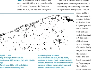
of the century the first hotels and summer homes were built in the area at Gilleleje (Figure 1 – 1898).
Starting in the late 1800s, Copen-hagen’s upper classes spent summers in the country, often building villas and cottages on the nearby coast. The
rail-road, and later the car, made it possible to trav-el further from Copenhagen and some families built cottages first at Hornbaek (10 km east of Gilleleje) and later in Gilleleje. O ften the family stayed there for the summer while the hus-bands commuted to Copenhagen. By 1940 the heath, dunes and grazed lands were completely develop-ed. At that time there were only 3,000 cottages in the county.
The late 1950s marked the start of a general building boom in Denmark. In the Graested-Gilleleje municipality, ap-proximately 64 percent of the cottages were built between 1960-79. O nly 23 percent were built before 1960; the
remainder are newer than 1979 (Figure 2 – 1962).
The need for building regulations became apparent, and laws were passed to protect the coastal zone in Denmark. The Nature Conservation Act of 1937 provided a coastal protection zone of 100 meters. The Danish Planning Act of 1974 divided the country into three zones that were regulated differently: an urban, a rural and a summer cottage zone. A Summer Cottage and Camping Act was passed, mandating that summer cottages only be used as secondary houses; no one was allowed permanent residence in a cottage. The 1990 modi-fication to the Summer Cottage and Camping Act made it possible for a municipality to permit owners who owned their house for longer than eight years to make it their permanent residence.
The planning act was supplemented in 1994 (Nature Protection Act) by increasing the coastal protection zone to 300 meters and imposed stricter regulations addressing altering of the natural habitat, erecting fences, park-ing caravans and subdividpark-ing proper-ties. The aim was to protect the coastal zone from further development, and at the same time allow the needed development of cities and their infra-structure, and tourism. It prohibited the designation of new summer cot-tage zones and required existing areas be reserved for holiday and leisure purposes. Existing summer cottage zones must not be used for urban
Urbanization of the North Coast
of Zealand, Denmark
Figure 1: 1898.
Map coverage: 7 km x 3.5 km
Heath area: 68.5 hectares (ha) with 2 build-ings
Forest area: 36 ha with no buildings Total number of buildings: 172
Remaining area: farmland
Loss of natural habitats, mostly heath, replaced by houses (both cottages and city houses) and forest. Forest area increases as summer cottages owners plant trees and convert farmlands to forest area.
Figure 2: 1962
Heath area: 6.8 ha with 4 buildings
development, even if these areas are close to cities and towns.
Nevertheless, in the newest regional plan of 1997, Frederiksborg County allowed the municipalities to convert nine areas from cottage zones to urban zones, a change from vacation to per-manent settlements. This violates the coastal planning zone of the planning act. County officials justify their deci-sion by claiming that the areas already have many houses built for permanent residence. These houses were given permanent resident status as a result of the 1990 modification to the Summer Cottage and Camping Act. These own-ers have rebuilt the small cottages to meet the demands for higher living and building standards, thus many areas have changed from cottage areas to perma-nent home areas. Also, since regulations do not exist for the construction of summer cottages, cottages will contin-ue to be upgraded to permanent struc-tures. As this occurs, and as demand for urban zones increases, these summer cottage zones will be transformed to urban zones. This sort of development is happening throughout Denmark (Figure 3 – 1985, present stage).
The municipality and the county of the North Zealand coastal area attempt-ed to allow the conversion of areas from cottage to urban zones; in essence from vacation to permanent housing. This effectively violated the countries plan-ning act. However, the Ministry for
Energy and Environment vetoed this effort. This is the result of the political differences between the liberal county and the municipality on the one side, and the new government which is Social Democratic on the other. The more liberal tend to disregard the restrictions in the 3-km coastal pro-tection zone while the Minister for Environment wants to follow the plan-ning act. This attempt, if nothing else,
demonstrates that the intention of the national planning act is not very strict and will be interpreted according to political considerations.
Urbanization of the North Zealand coast of Denmark has resulted in loss of coastal habitat, as well as loss of pub-lic access to the shore. Although there is to be public access to all beaches, it is often difficult to get there. Several roads do end at the beach; however, most landowners directly on the coast
have built fences to protect their prop-erties (Figure 4). There is a national initiative to secure public access; how-ever, this can only be done by buying sites and establishing public facilities for amenities such as parking areas and toilets. This is expensive and funding would be from the local government.
Another issue is coastal erosion. Since the 1930s, groins have been built to stop coastal erosion and protect the cottages and houses. Not only has this impacted the scenic quality of the area, but it has caused continued loss of the sandy beaches resulting in continued building of new groins and breakwaters. Until recently, coastal protection was done by the individual landowners with no county regulations; now the county must approve new projects. Also, the understanding of coastal dune dynamics has improved, and the management strategy is slowly changing from con-structing breakwaters and still bigger groins to letting nature take its course.
There is an urgent need to address problems of continued urbanization
along the Danish coast. Despite the planning act’s coastal planning zone of 3 km, and the attempts to move the urbanization inland behind the 3-km zone, urbanization can still takes place along the coast and especially in the summer cottage areas.
For further information contact: Henrik Suadicani, Roskilde University, Building 10.2, P.O. Box 260, DK-4000 Roskilde. Denmark.
E-mail: [email protected].
Figure 4: Restricted public access to the beach.
Figure 3: 1985
Heath area: 9.4 ha with 3 houses