Engaging Farmers’ community in climate
change response and adaptation plans: in
Sub-district Sedayu, Lampung Province, Indonesia
Tumiar Katarina Manik
1, Bustomi Rosadi
2, Onny Chrisna Pandu Pradana
3,Purba
Sanjaya
41,4Department Of Agronomy, Faculty of Agriculture, Lampung University, Indonesia 2Department of Agriculture Engineering, Faculty of Agriculture, Lampung University, Indonesia
3Department of Agronomy, Department of Seed Science, Politeknik Negri Lampung
Abstract— Farmers as the producers of food are one of vulnerable community related to climate change. Therefore assessing climate change impact on farmers’ community is necessary not only for their living but also for our food security. However, effective responses to climate change require at least community support and, ideally, genuine community participation. Sedayu is a village (450-550 m asl) with normal rainfall about 2500 mm/year and more than 30% has land slope about 8%; Sedayu had a possible risk of flash flood. Efforts to apply climate change adaptation are needed since 76.25 % of the population is farmers with paddy, cocoa and coffee as their main products. Decreasing disaster risk effectively and planning for handling emergency situation was started with analyzing the community condition physically and socially. The community participated with giving information and data needed. Through some trainings and using tools they were able to discuss and analyze the data and eventually formed the Local Resilience Action Plan (LRAP) which will be part of Regency Medium Term Development Plan. This paper reported the analysis of the village condition related to the possibility of disaster risk caused by climate and the action plan as an effort to climate change adaptation.
Keywords— action plan, adaptation, climate change, farmers, disaster
I. INTRODUCTION
Climate Change is defined as statistically significant variation in either mean state of the climate or in its variability, persisting for an extended period, typically decades or longer [1]. Rising fossil fuel burning and land use changes have emitted, and are continuing to emit, increasing quantities of greenhouse gases into the Earth’s atmosphere. These greenhouse gases include carbon dioxide (CO2), methane (CH4) and nitrogen dioxide (N2O), and a rise in these gases has caused a rise in the amount of heat from the sun withheld in the Earth’s atmosphere, heat that would normally be radiated back into space. This
increase in heat has led to the greenhouse effect, resulting in climate change and are expected to affect many aspects of human activities including tropical cyclones (hurricanes and typhoons), floods, droughts and heavy precipitation events ([2], [3]).
Climate change could severely exacerbate the impact of natural hazards, disaster and extreme weather and will have wide-ranging effects on the environment, and on socio-economic and related sectors, including water resources, agriculture and food security, human health, terrestrial ecosystems and biodiversity and coastal zones. Therefore, effective responses to climate change require at least community support and, ideally, genuine community participation.
There are some concepts in qualifying communities response to climate change: risk, vulnerability, adaptation and resilliance. Vulnerability is the degree to which a system is susceptible to, or unable to cope with, adverse effects of climate change. Adaptation is initiatives and measures to reduce the vulnerability of natural and human systems against actual or expected climate change effects. Resilience is the ability of a social or ecological system to absorb disturbances while retaining the same basic structure and ways of functioning, the capacity for self- organization, and the capacity to adapt to stress and change [7]. In other words, adaptation is a process through which societies make themselves better able to cope with an uncertain future. Therefore, safety and resilience can be addressed most effectively by building communities’ capacities to reduce their vulnerabilities to hazards, recognizing that risk is ultimately driven by the combination of the hazard environment and vulnerabilities to those hazards. Without addressing the vulnerability side of the equation, community exposure to natural hazards cannot be reduced in a sustainable way that contributes to resilience [5].
population lives in coastal regions; Besides common impacts of climate change, coastal communities face the additional threat of rising sea levels. Therefore, they need to plan ahead to adapt to these changes.
In North East Victoria, Australia three acitivities were conducted for activating communities involvement: workshops for the seniors in community, leadership trainings for the existing grassroot community groups and mobile outreach using fun activities for public [4]. In Batticaloa city, Eastern coast of Sri Lanka, the community was involved using participatory approach in developing coastal greenbelts, to prevent coastal erosion, and mitigate the adverse impacts of natural coastal hazards on human lives and property [7]. Over the last few years, unusual and erratic climate conditions have had a detrimental effect across global coffee producing belts leading to considerable economic losses in many countries. In Uganda, Farmers formed various type of asscociations that could support access to other service providers and networks, thereby developing vertical social capital and enhancing the adaptive capacity of smallholder farmers [6].
Sedayu is a village in mountainous area of Tanggamus District in Lampung Province. Located close to Semaka Bay and Bukit Barisan National Park makes this area vulnerable to flash flood, landslide but also drought. To prevent from potential disasters in the future,Sedayu needs better integrated and coordinated plans. The plans would be one part of disasters resilliance which composed from identification of potential disasters, disasters risk analysis and finally, actions and activities focus programs. Sedayu residence and local communities and government were involved in all of those processes and steps. The processes and results were documented in what we callled Local Resilience Action Plan (LRAP). LRAP was a proposal in community level contained efforts deals with adaptation to climate change and disasters reduction and resilliances. The LRAP was a tool for building synergic communications among the local residences, local government, academic institutions, NGO and others. In other words, LRAP was the result of Participatory Action research (PAR).
PAR is a reflective process of progressive problem-solving led by individuals working with others to improve the way they address issues and solve problems. PAR is generally applied within social learning contexts, where multiple actors collectively construct meanings (problem definition, objectives) and work collectively toward solutions [10] This research paper explains such methodology in composing the LRAP and the action plans following the LRAP as one example in engaging farmers community to adapt and response to possible disasters related to climate change.
The purpose of composing the LRAP were: increasing community understanding related to climate change, the
impacts and how we responds to it; arranged participation action plans to cope with climate change impacts and improving community resillience, to integrate the climate change action plan with local government development program, to guide the community leaders in running programs related to climate change.
II. MATERIALS AND METHOD
2.1 Climate data analysis to identify climate change Rainfall and air temperature trends were analysed in simple ways by arranging the data from 1976-2005 (30 years). By averaging the 30 years data series, normal value of the rainfall could be counted. The data series divided by 5 years period each and compared to the normal value to get descriptions of possible shifting and changing in rainfal patterns over the 30 years period. Rainfal data series was also arranged from the lowest to the highest and divided into certain ranges to calculate rainfall frequencies. Similar analysis was done to the temperature data.
2.2 Composing LRAP 2.2.1 Organizing Processes
Composing LRAP document started with forming the organization, set up the community commitments and trust; formed the working group in community level including stakeholders representatives, local government agencies, and community leaders. The working groups arranged and formulated what action plans would be excecuted to get data and information related to adaptation and reducing disasters risks. They also explored all stakeholders in order to structure them in their groups
2.2.2 Evaluation of community vulnerability and capacity For completing the materials for the LRAP, data and information about Sedayu condition and characteristics was collected. Data could be collected from secondary sources (literatures, documents) or primary sources (observations, interviews). In this steps trainings were conducted to introduce supporting tools to evaluate the community vulnerabilities and capacities.
The supporting tools were: hazzard mapping, historical hazzards analysis and season calendar. Hazzard mapping was done for identifying areas that had riks like flood, landslides, sea level rising, erosion, abrasion, drought, storms and endemic diseases. Historical hazards analysis used for getting deep descriptions about hazzards in the past whether they changed in time: characteristics, intesities and behaviours that the society could aware about the trends and variations in period of time. Season calendar used for analyzing periodic changes including stress, hazards, or diseases that could be used to evaluate climate information in making plans.
This step was conducted based on focus group discussion of the village community; they decided what actions and activities needed for their village.
2.2.4 Formulated the action plans
After made decisions about the actions that would be taken, then the community formulated the steps and plans for the actions so that the action plans met the target and the budget
2.2.5 Evaluation of the action plans and resilliance criterias In this part all activities that proposed by the community were evaluated whether they were related to resilliance criterias and could improve the community strength and ability related to adaptation and resilliance to clima change. 2.2.6 Making priority in action plans in climate change After evaluating all the actions proposals then the community set priorities for the action plans chosing the most important and gave major contributions for the community in facing climate change impacts and possible future hazards.
2.2.7 Monitoring and evaluation
During the implemention of the action plans, it is necessary to have ways in monitoring and evaluating the activities.
III. RESULTS AND DISCUSSIONS
3.1 Sedayu climate 3.1.1 Rainfall
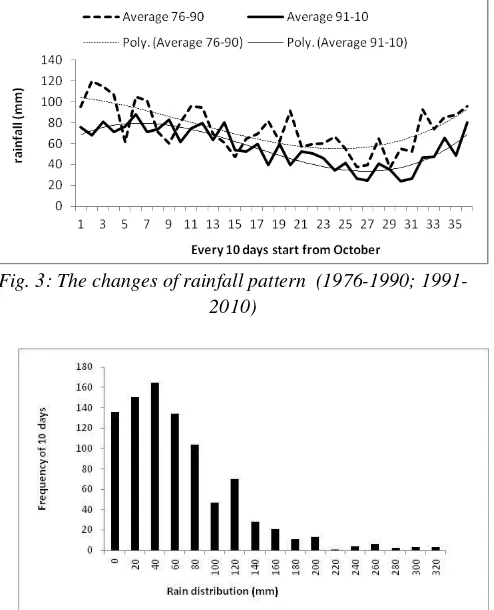
As a village in mountaneous area Sedayu has constant high rainfall al year, more than 50mm/10 days; no clear distinction between rain and dry season. Climate analysis in the period of 1976-2010 showed that Sedayu had 310 rain days (rain season) and only 50 no-rain days. The highest rainfall was 99,3 mm (the 2nd week of October) and the lowest was 29,1 mm (2nd week of June) (Fig.1). High rainfall in October to Februari should be a warning since it would be a potential for landslides in hilly areas The normal rainfall for total annual was 2314 mm. Rainfall tended to decrease below the normal line after 1992 (Fig. 2) and average 10 days reinfall in period of 1991-2010 was lower than in period of 1991-2010 (Fig. 3). Fig. 4 was rainfall distribution during the 30 years, rainfall most often fall on the range of 20 – 40 mm in 10 days.
3.1.2 Air temperature
Global data showed that air temperature tended to rise 0.0018/month with base temperaure was 26.7 oC (Fig. 5).
Fig. 1: Average 10 days rainfall in the period of 1976- 2010
Fig. 2: Normal rainfal pattern in Tanggamus District (1976 2010)
Fig. 3: The changes of rainfall pattern (1976-1990; 1991- 2010)
Fig. 5: Temperature rising trend (1980-2002)
3.2. Physical description of Sedayu 3.2.1 General information
Sedayu consists of 8 neighborhood communities; most of the residences live on low ground area but plant coffee and cocoa on the high ground or hills area. The population consisted of 52, 01 % male and 47,99 % female, in addition 13,32% was children and old age people who considered vulnerable to any disturbance. Most of them had permanent houses to live in quite good condition including the sanitarian facilities; however, the availability of clean water was limited in some area.
Education level in Sedayu was quite low, 44,79% graduated from primary and junior high school, 11,23% from high school and only 0,01% entered university level, but they had good knowledge about environment issues. Sedayu people was kind of “transition” in their way of life; they did not involve in communal works as tradition community do but they hold a belief on their ancestors protection.
Fig. 6: Administration border of Sedayu, Tanggamus District
Most of the Sedayu people made their living ftom agriculture activities (76,25%); small number (7,75%, 8,06%, 1,38% respectively) worked as local traders, various services and government officers. In general, they had moderate income level.
3.2.2 Land elevation, slopes and land cover
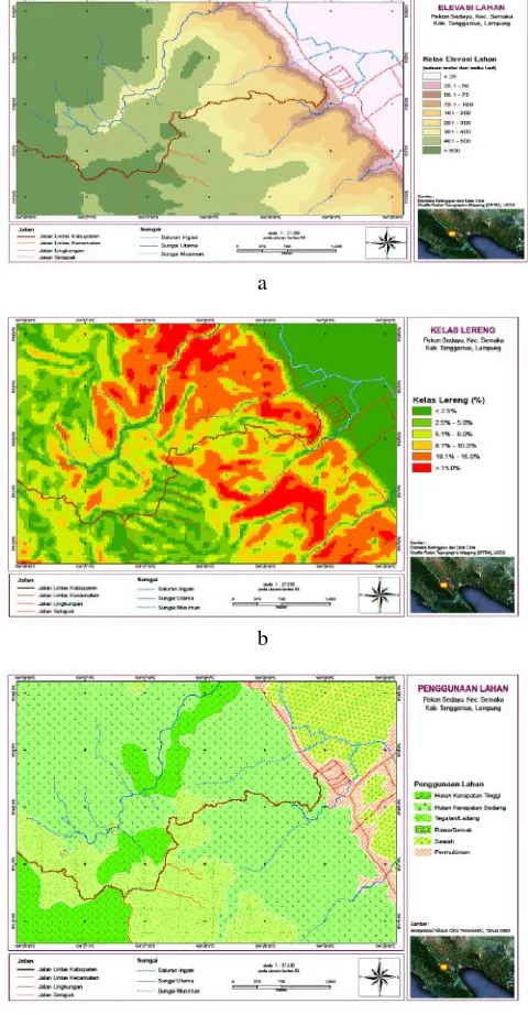
Sedayu had gradient elevation from low area (~ 25 m, 16.13%) up to > 500 m (41,27%). Lowland area, especially in riparian area, was proned to flood, while the highland was proned to landslides. Most of the Sedayu land was flat to a bit tilted (72,64%) and 27.36 % was steep. Sedayu was covered by forest (42,85%, both natural and secondary forest) while 52,69% was agricultural area (paddy and other commodities field) and the rest was residential area Fig.7.
a
b
c
Fig. 7: Land elevation (a), slopes (b) and land cover (c) of Sedayu, as factors of possible disasters
3.3 The possible hazards caused by integrated climate factors and the physical condition of Sedayu
on the physical environment of the area. In lowland area especially in riparian area rainfall could potentially cause flood. As stated above 16,13% of Sedayu was lowland area, therefore, floods could be one disaster of Sedayu.
Flash flood could happen because of cumulated water in highland soil and when the soil could not hold the water, it would rush to and flood the lower area. Flash flood had a higher possibility to occur in Sedayu since it surrounding by hillyarea.
Landslides did has a potential to happen in Sedayu but the probability might low since only 27.36 % was steep land while the rest was categorized as flat, except if the rain intensity was high and for long time.
Land cover influences the soil ability in absorbing and holding water, therefore, preventing from landslides. Sedayu has a good soil surface coverage in forest area; however it still had almost 50% for residential area and agricultural area which might not good in holding water. Flood from the river, flash flood and landslides were still had possibilities to danger Sedayu.
Those analysis above were closely reflected on disasters historical records in Sedayu (Tabel 1) flash floods were the major disasters in this area. Part of the forest upland area in was converted to coffee and cocoa fields, when the rain occured with high intensity or in prolong time, flash flood and landslides are most predicted disasters.
3.4 Community vulnerability and adaptation capacity related to social, economic and local government policies There are various factors in evaluating community vulnerability and adaptation capacity. From the interviews and quosioners the vulnerability and adaptation capacity of Sedayu was described as follows:
Tabel.1: Historical disasters records and management in Sedayu
1986 flash flood destroyed the cemetry and
3.4.1 Climate change adaptation on social matters
Health facilities and access and income ussualy were indicators for adaptation capacity. Health and sanitation in Sedayu was considered good; however it still lacked of health facilities especially medical doctor; only one midwife was available in Sedayu and no community health centre.
The majority of Sedayu made their living from agriculture activities by planting coffee and cocoa. Sedayu has formed farmers organization and it runs very well. The farmers organization was independent and able to manage the members raw productions into processed and comercial products. However, they still need more knowledge in improving cultivation techniques for their coffee and cocoa. In general, Sedayu residences had good income; they could be considered as had a good capacity in dealing with climate change impacts as along as there are some way to train them. For example, they could develop their own irrigation facilities. However, farmers did not have an easy access to bank and finacial facilities, no bank local branch offices in this area.
3.4.2 Climate change adaptation capacity on physical environment matters
Transportation including evacuation routes and infrastructures facilities were basic requirements in facing any disaster. Sedayu did not have permanent roads and bridges facilities; the main roads just had been constructed in 2012. Some public facilities like schools, mosques or other buildings could be used as shelter in disasters time but not adequate yet. In general, public and infrestructures facilities in Sedayu needed much improvement.
3.4.3 Climate change adaptation capacity on human resources matters
considered vulnerable. They needed more information and guidance to take care their environment to prevent them from disasters.
3.4.4 Climate change adaptation capacity on local government policies
Adaptation capacity of Sedayu local government was low since there was no plans and commitments on resiliance and climate change adaptation on its policies, no rules, mechanisms, structures and guidance for managing the village environment, no connections between policies and regulations in village development, and have no external partners in developing the village. All activities: economics, social, environment were community spontaneous and independent movements.
3.5 The LRAP processes and implementation 3.5.1 Organizing Processes
The team for writing the LRAP consisted of the Sedayu village government; Farmers organisation leaders; the district level of BNPB (Badan Nasioanl Penanggulangan Bencana; National Board of Disasters Resilliance), the NGO: Mercy Corps Indonesia and the academic: Universitas Lampung.
3.5.2 Evaluation of community vulnerability and capacity Hazard mapping has been done with results as desribed in Figure 8 (a.b,c); while the hitorical records of past disasters was presented in Table 1.
3.5.3 Identification choices of actions or activities
After some discussions among the stakeholders the activities that they proposed were: replanted tress on bare and open land to prevent the village from flash floods and landslides, developed and trained community organisations of disasters awareness, procurement of disasters resilliance equipments, renovation of public building dan made them as shelters during disasters, constructed walls along the river, gabion along the main road and water tunnel as landslides, flood and flash flood preventation.
3.5.4 Making priority in action plans in climate change adaptation
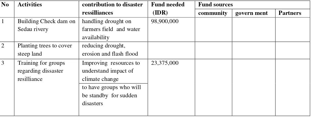
After evaluating all the actions proposals including budget source and time frame of this project, buiding a dam was set as the highest priority. All the proposed activities were presented in Table 2.
3.6 Integrated LRAP on mid-term local development plans of Sedayu
Eventually the activities proposed on LRAP of Sedayu which was discussed and planned by the communuty stakeholders was integrated in local government development mid term (5 years) plans. With this method and processes, adaptation action and disaster resilliance related to climate change was adopted on local government legal documents.
The Participatory research methods which was conducted in Sedayu could be considered successful ( Fig. 8). After delays due to mobilization of the construction machinery to the site, check dam construction was resumed and completed. Construction was implemented collectively by paid local labors and community volunteers while the construction machinery was constributed by Indonesian local board of dissasters management. All works was supervised by an NGO, Mercy Corps Indonesia.
There are many methods in engaging local communities to some action or pregram for dissaters resillience. In highland locations in Bolivia and Ecuadorthe poorest regions of the Andes the local organisations created program called Katalysis which focused on enhancing local knowledge of climate change and creating opportunities for coping with it [8]. However, Katalysis is in conflict with dominant institutional designs since its principle was donor and development agencies must hand over more trust and responsibility to communities to design and implement their own agendas.
Table.2: List of activities proposed by Sedayu community for adaptation capacity to climate change impacts
No Activities contribution to disaster
ressilliances
Fund needed (IDR)
Fund sources
community govern ment Partners
1 Building Check dam on Sedau rivery
handling drought on farmers field and water availability
98,900,000
2 Planting trees to cover steep land
reducing drought, erosion and flash flood 3 Training for groups
regarding dissaster resilliance
Improving resources to understand impact of climate change
23,375,000
No Activities contribution to disaster ressilliances
Fund needed (IDR)
Fund sources
community govern ment Partners
4 Procure
ment of disasters manage
ment equipments
to improve adaptation capacity of Sedayu
36,475,000
5 Renovation of community meeting place for shelters
for evacuation in disasters
81,293,000
for a meeting place of the disasters resilliance groups
for an information centre
6 Built river wall preventation from river flood and flash flood
120,500,000
7 Organic crops (paddy and cocoa) training
to improve farmers capacity in facing changing climate
32,625,000
8 Built clean water facility
to help the community during drought
-
8 Dredged the river and put gabion
to deepen the river base so that it could flow water from the upper part
-
to prevent soil erosion along the river bank
Total 393,168,000
Local people and outsiders need to be free to learn from each other, and to learn as they go along. In Solomon Islands, countries recognized by the IPCC as being among the most vulnerable to the impacts of climate change although contributing the least to GHG emissions [2].
Critics of top-down, expert-driven approaches to adaptation suggest the need for tools and methods capable of addressing the gap between scientific and local understanding of climate, therefore they formed Participatory Three-Dimensional Modelling (P3DM) for adaptation planning. The results showed that P3DM is able to bridge topdown and bottom-up approaches to adaptation by creating a space for mutual learning. Further research is necessary in order to overcome technical barriers to the integration of indigenous and scientific knowledge such as the downscaling of climate information to a scale compatible with community information as visualised on the relief model [11]. The LRAP methods applied in Sedayu was similar with urban participatory climate change adaptation appraisal (PCCAA) which was conducted in Mombasa (Kenya) and Estelí (Nicaragua). There the steps were community characteristics; severe weather; vulnerability to severe weather; asset adaptation; and institutions supporting local adaptation. It concluded that the PCCAA can become an important tool in the dialogue between communities and local authorities concerning the most appropriate interventions that will best
assist them to build long-term resilience in the face of changes in weather conditions associated with climate change [12].
It is obvious that informing local communities about likely change effects, for identifying and dealing with potential risks and vulnerabilities, and also for encouraging and mobilising community activities geared to minimising these risks is important. For that purpose it needed people with a willingness to engage with others in open, unfettered and respectful multi-disciplinary discussion [9].
Fig.8: Check dam construction as a project based on community adaptation plans
IV. CONCLUSIONS
adaptation capacity. However, Sedayu was considered vulnerable because of local government weakness in regulations and commitments to secure their environment and to strengthen its resilience in terms of disasters caused by climate change.
Engaging local community together with other stakeholders in understanding and taking action for adaptation capacity and disaster resilliance related to climate change is important. From doing analysis on the local condition, the community could propose activities and programs which were met their needs. Guidances from external partners (NGO, Academic and other agencies) helped the community to force local government to adopt the LRAP into their legal documents and integrated it to their mid-term development plans.
ACKNOWLEDGMENT
We would like to thank Mercy Corps Indonesia and BNPB Tanggamus District for providing financial supports and equipments during this work.
REFERENCES
[1] IPCC. Special Report on Emissions Scenarios. Intergovernmental Panel on Climate Change Secretariat. Geneva, Switzerland. <http://www.grida.no/climate/ipcc/emission/. 2000. [2] IPCC. Fourth Assessment Report. Intergovernmental
Panel on Climate Change Secretariat. Geneva, Switzerland. http://www.ipcc.ch/. 2007.
[3] G. A. Meehl, T. F. Stocker, W. D. Collins, P . Friedlingstein, A T Gaye, J M Gregory, A Kitoh, R Knutti, J M Murphy, A Noda, S C B Raper, I G Watterson, A J Weaver and Z-C Zhao. 2007. Global Climate Projections. In: Climate Change 2007: The Physical Science Basis. Contribution of Working Group I to the Fourth Assessment Report of the Intergovernmental Panel on Climate Change. [Eds Solomon S, Qin D, Manning M, Chen Z, Marquis M, Averyt K B, Tignor M and Miller H L]. Cambridge University Press. 2007.
[4] Riedy, Chris. Engaging Communities In Climate Change Adaptation: A Case Study From North East Victoria. Institute for Sustainable Futures, University of Technology, Sydney, NSW. http://www.coastal
conference.com/2012/papers2012. 2012.
[5] IFRC. Climate Change Adaptation Strategies for Local Impact. 2009
[6] J. Frank, and P. Buckley, C. 2012. Small-scale farmers and climate change. How can farmer organisations and Fairtrade build the adaptive capacity of smallholders? IIED, London
[7] D. L. Senanayake, P. K. S. Mahanama , K. S. Barthelot .“Community Participation For Climate Change
Adaptation: Participatory Approach For Planning And Design Of Coastal Green Belts In Batticaloa” In
SAITM Research Symposium on Engineering
Advancements (SAITM – RSEA, 2013). p:12-15 S. 2013.
[8] Sherwood and J. Bentley. Katalysis: helping Andean farmers adaptation to climate change. Participatory Learning and Action 60.Ed H. Ashley, Nicole. K, and A. Milligan. IIED. 2009.
[9] H. Ross, S. Shaw, D. Rissik, N. Cliffe, S. Chapman , V. Hounsell , J. Udy, Ng. Trong Trinh and J. Schoeman. “A participatory systems approach to understanding climate adaptation needs”. Climatic Change Volume 28 No 1 and 2. 2014. DOI 10.1007/s10584-014-1318-6 [10] L.A. German, A. M. Tiani, A. Daoudi, T. M.
Maravanyika, E.Chuma, C. Jum, N. Nemarundwe, E. Ontita and G. Yitamben. The Application of Participatory Action Research to Climate Change Adaptation in Africa. International Development Research Centre and Center for International Forestry Research.2012
[11] P. A, Paper. “Participatory mapping for adaptation to climate change: the case of Boe Boe, Solomon Islands”. Knowledge Management for Development
Journal 9(1): 24-36. 2013. available at
http://journal.km4dev.org/