INAFOR 2015-PAPER D4
INTERNATIONAL CONFERENCE
OF INDONESIA FORESTRY RESEARCHERS III – 2015
21-22 OCTOBER 2015
INTEGRATED APPROACH FOR LAND USE CHANGE ANALYSIS AS
AN EFFORT TO CLIMATE CHANGE MITIGATION IN MEDAN NORTH
SUMATERA PROVINCE
Rahmawaty1, Monnica Zalukhu1, Abdul Rauf2
1Forestry Study Program, Faculty of Agriculture, University of Sumatera Utara, Jl. Tri Dharma Ujung No. 1
Kampus USU, Medan 20155, Indonesia email: [email protected]/[email protected]
2Agroecotechnology Study Program, Faculty of Agriculture, University of Sumatera Utara, Jl. A.Sofyan No. 3
Kampus USU, Medan 20155, Indonesia
Paper prepared for
International Conference of Indonesia Forestry Researchers III – 2015 (3rdINAFOR 2015) 21-22 October 2015
INAFOR SECRETARIAT
Sub Division of Dissemination, Publication and Library
RESEARCH, DEVELOPMENT AND INNOVATION AGENCY MINISTRY OF ENVIRONTMENT AND FORESTRY
INTEGRATED APPROACH FOR LAND USE CHANGE ANALYSIS AS
AN EFFORT TO CLIMATE CHANGE MITIGATION IN MEDAN NORTH
SUMATERA PROVINCE
Rahmawaty1, Monnica Zalukhu1, Abdul Rauf2
1Forestry Study Program, Faculty of Agriculture, University of Sumatera Utara, Jl. Tri Dharma Ujung No. 1
Kampus USU, Medan 20155, Indonesia email: [email protected]/[email protected]
2Agroecotechnology Study Program, Faculty of Agriculture, University of Sumatera Utara, Jl. A.Sofyan No. 3
Kampus USU, Medan 20155, Indonesia
ABSTRACT
Changes in land uses is among the important issues in North Sumatra, especially in the city of Medan. To support climate change mitigation, this study aimed to analyze changes in land use during the period 2000 to 2011 and to identify main factors affecting the changes of land uses in Medan city. This study was conducted from March to August 2013. The Geographic information system (GIS) with overlay technique was used to analyze land use changes. The analytical hierarchy process (AHP) with questioner and interview was used to determine the cause of changes and the factors driving the changes in land use. Field observations were also undertaken to assess the biophysical conditions due to changes in land use. The results showed that for eleven years, the greatest extensive changes in land use were in the form of dry land farming mixed shrubs become dry land agriculture, followed by changes in rice fields becomes settlement. Other land use changes that affect widely were changes of shrubs into oil palm plantations and fish pond. Economic factors were the main cause of changes, followed by social factors and ecological factors. Economic criteria selected by respondents showed as the most important priority for activities in Medan City, that cannot be separated from economic activities that has strong alignment with spatial development. Changes on land uses basically is influenced by economic or financial considerations of agricultural land that has been converted into non-agricultural use, either for residential, offices, and other facilities. In order to mitigate climate change in Medan City, role of all stakeholders, especially local governments should be improved in order to minimize in land uses.
Keywords: AHP, climate change, GIS, Medan City, mitigation, plantation
1. INTRODUCTION
Increasing human population, has consecquences on accelerating demands and intensity of human activities on the land with various degrees of impact on all of the material and natural resources in the world. Population pressures have accelerated the increased in land values and diverse demand for land. Changes in land uses in Medan City need to be monitored because it affects on climate change, especially in the city. In North Sumatra,some studies on land use have
Some of these studies explain on how changes in forest land into plantations, agricultural land into non-agriculture. Other studies show on mangrove forest that turned into ponds, also changes on the uses of rice fields to other uses. Human activities brought on the changes of urban land uses from year to year. According to Parengkuan (1991) that urban activities will grow if the population is growing. Because the land is permanent, some land will be contested by the activities that have criteria in accordance with the land is located. Competition in land use has accumulated and caused land originally allocated for a particular activity in the city plan, often been used by other types of activities at implementation.
Human needs on goods and space impact on land use change. Increased interaction between people and land influence on the land use change. Remote sensing technology and Geographic Information System (GIS) are suitable methods to monitoring land cover change and to support management effort of these resources sustainability. Analysis of factors causing changes in land cover using Analytical Hierarchy Process (AHP) can provide several solutions in Medan to improve the situation. This study aimed to analyze changes in land use in the period 2000 to 2011 and to identify the main factors causing the changes of land use in Medan North Sumatera Province.
2. MATERIALS AND METHODS
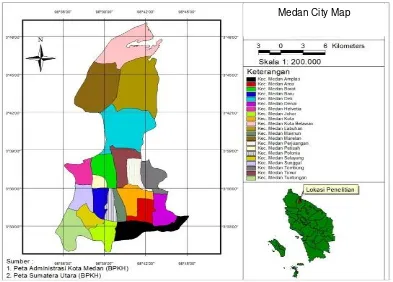
This study was conducted fromMarch to August 2013. Data collection was conducted from March 2013 to April 2013, and the data analysis was conducted from May 2013 to August 2013. The research was undertaken in the area of Medan, North Sumatra Province (Figure 1). Data processing was performed at the Laboratory of Integrated Forest Management Department of Forestry, Faculty of Agriculture, North Sumatra University.
The Geographic information system (GIS) with overlay technique was used to analyze land use changes. The analytical hierarchy process (AHP) with questioner and interview was used to determine the cause of changes and the factors driving the changes in land use. Field observations were also undertaken to asses the biophysical conditions due to changes in land use.
All data (thematic layers) gathered from different offices were projected on UTM (Universal Transverse Mercator) Zone 47 N before determination of land use/land use change. Then, Land use/land use change in the area was determined by overlaying maps of different periods, using ArcView GIS and ArcGIS (multi-thematic intersect operation). The data gathered were encoded in the computer using the spreadsheet program (Microsoft Office Excel) and output tables were exported as data based file (dbf) table.
Figure 1:Study site map
.
3. RESULTS AND DISCUSSION
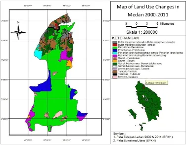
Landuse in the city of Medan consists of ten types according to Ministy of Forestry land cover map, namely: Secondary Mangrove Forests, ponds, settlements, oil palm plantations, rice fields, Shrub lands, Airport, Dry land Agriculture, dry land farming mixed shrubs, and Body Water (Table 1 and Figure 2). Based on the results of ground checking, the value of an accuracy of 96.25 % i.e. 80 points are 77 determined the correct point in a spreading ground check. It shows that the results of the interpretation of the maps are accurate. According to Rahmawaty et al.(2012), the accuracy level of ≥ 80 is considered to be correct. The matrix extensive changes in land use in the city of Medan during the period from 2000 to 2011 can be seen in Table 1.
The dominant changes of land area from 2000 to 2011 occurred on Shrubs become fish pond, (Table 1). Extensive land cover in 2011 showed an increase for settlement from 439.48 Ha (2.45%) to 18 344.09 Ha or 61.90%, oil palm plantation area from 2147.70 Ha or 7.25% to 18344.09 Ha or 61.90%, agricultural from 2166.62 Ha or 7.31% to 2573.35 Ha, or 8.68% of the total land area of the city of Medan. Extensive land cover in 2011 showed an decrease for shrub swamp from 2223.23 Ha or 7,50%, rice fields from 354.55 Ha or 1.20% of the total land area. Dry land farming mixed shrubs has decreased drastically in which this land use may no longer exist in 2011 (Figure 2). On the other land use types that did not change with no addition or reduction in the extent of the body of water, secondary mangrove forests, and airports. Matrix of extensive changes of land use in Medan from 2000 to 2011 is presented in Table 1.
Table 1. Matrix land use changes in Medan city for the period 2000 to 2011
dry land farming mixed shrubs 552.991 0.000 51.375
Figure 2: Map of Land Use Changes in Medan City
Based on observations and field surveys and maps of land use change in Figure 1, it can be seen that the location of changes in land use secondary mangrove forests into farms is located in the coastal area of Medan, namely district of Medan Belawan, Medan and Medan Labuhan Marelan. The potential of the coastal area is very supportive of the change. The coastal area in terms of various designations is a highly productive area. It became one of the causes of the changes to the mangrove forest. Changes occur can also be caused by a variety of interests and human activities. This is consistent with that expressed by Onrizal (2010) which stated that the change of the primary and secondary mangrove forests into non-forest areas caused by the conversion of mangrove, especially clearing forests for farms, oil palm plantations, settlements and other agricultural areas, the same was also presented by Rahmawaty et al (2011).
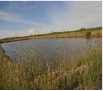
Human activities in urban areas, especially in the city of Medan which has been in the development stage were very rapidly pressing the existence of mangrove ecosystems with a view to economic aspects in meeting the needs of the surrounding community. Based on observations and field surveys, dry land farming mixed shrub turned into dry land agriculture may be because local communities using land that is not functioning initially located in the area of their agricultural land to expand agricultural land. Dry land agriculture commodities can be produced in larger quantities than before and there is no land is no longer productive. The land use changes are found in Marelan Sub District. Changes in land use shrubs into the pond through the observation of many found in Marelan Sub District (Figure 3 and 4). This is because the presence of Marelan which is the coastal area of Medan so it can potentially be a pond land. Communities also want to take advantage of nonproductive land at an earlier time to become ponds that can be productive and meet the needs of the community.
Figure3: Changes from mangrove forests into fish pond in Marelan Sub District
Figure 4: Changes from scrub into fish pond in Marelan Sub District
Likewise to changes in land use shrubs to oil palm plantations located in Medan Belawan Sub-district. Society is just solely utilizing non productive land into productive land. Moreover, the city of Medan is one of the coastal areas of the East Coast of North Sumatra, according Purwoko (2009). The agricultural sector has a strategic potential for development in Pantai Timur of North Sumatra, because the land is fertile and suitable for food crops, horticulture and plantation crops.For paddy fields land use changes into this settlement occurred in several Sub-districts in Medan city, namely: Medan Helvetia, Deli, Polonia, Selayang, Johor, Amplas, and Medan Area. Land use settlements as has been observed is dominating land use in Meda. This is due to the rapid development in various fields and high population growth, more lands are needed for the construction of various sectors as well as for tourist attractions. Viewed from the physical contours of the flat rice fields have potential and fit for settlement so that society or the various parties to convert them into settlements. This is consistent with the statement of Irawan (2005) and Rahmawaty (2011) which stated that the greater conversion occurs in rice fields compared to dry land because it is influenced by three factors and one of them is the development of non-agricultural activities such as residential complexes, shops, offices, and industrial areas easier carried out on paddy land is more flat compared to dry land.
reduced the amount of rice production. In addition, the decrease in agricultural land area, it can be indicated to the increasing number of buildings constructed in the city of Medan. The dominant factor influencing the decision of farmers in converting land productivity and the proportion of income is from agriculture.
Changes in secondary mangrove forests and shrubs into fish ponds by observation can occur due to changes in the region. According to Rabiatun ( 2012) in his research on Land Suitability Analysis and Settlement Policy in the Coastal Region of Medan, the coastal region is a unique area because it is a mixture of land and sea, it affects the physical conditions which are generally located in the surrounding area sea has a relatively flat contour. The existences of these conditions are very favorable for coastal areas used as areas of potential in the development of the whole region. Land use changes during the period 2000 to 2011 to change shrubinto palm oil plantations, and dryland farming mixed shrub became dry land agriculture occurs due to the mindset of the people to take advantage of unproductive land into productive. In addition, the land use changes occur in many coastal areas are also due to the potential and the physical state of the coastal area. According to Purwoko (2009) that the agriculture sector has a strategic potential for development in the East Coast region of North Sumatra, because the land is fertile and suitable for food crops, horticulture and plantation crops.
The dominant factors that cause changes in land use in Medan by using AHP analysis, was obtained by weighting the results of recapitulation weighting of criteria each respondent. Most of the respondents chose the economic criteria as the dominant factor causing changes in land use (0,425) or ranking1 in relation to the target or goal in a hierarchical structure. Furthermore, the social criterion is0.422 or ranking 2 and ecological criteria is 0,153 or ranking 3. Economic Criteria chosen as the most important priority by respondents as it is considered that the activity in the downtown area cannot be separated from economic activities that have a spatial alignment with development. This is also confirmed in research by Gani (2004) of the Land Use Pattern Changes in Binjai Based Land Use Relationship with Growth, stating that population growth and economic development for the city resulted in changes of urban land uses that will change the layout of the city. Therefore, economic criteria can be used as a dominant factor influencing changes in land use in the city of Medan.
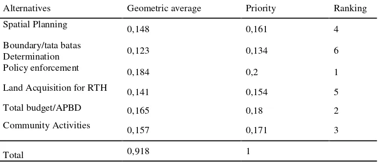
Based on calculations using the expert choice in AHP analysis method, in the same way with the calculation criteria for the calculation recapitulation of alternative level of each respondent can be seen in Table 2.
Table 2. Summary of the final calculation of alternative level of each respondent
Alternatives Geometric average Priority Ranking
Spatial Planning 0,148 0,161 4
land acquisition for RTH (0.154) and the determination of boundaries (0.134).Alternative policy enforcement chosen becomes the most important priority in accordance with the target structure of the hierarchy. They assume the policies set by the government for each space that make the city respond to human influence in it is very influential on land use change. Article 7 LAW No. 26 of 2007 also emphasized the importance of policy enforcement. Control on land uses is done through permit utilization of space, provision of incentives and disincentives, as well as the imposition of sanctions. Utilization of space that is not in accordance with the spatial plan, both of which are equipped with a license or not having a permit, subject to administrative sanctions, sanctions of imprisonment, and / or criminal penalties.
Lack of policy enforcement effect on land use change in Medan city. That can also be seen from the research results of Nababan (2012) about Studies on Land Use in the Bagan Deli Village which concluded that the lack of socialization of the RTRW make people do not understand and do not know the direction and policies. They became one of the factors of change in land use. Many housing and settlements had already been constructed with or without permit, and these constructions do not follow rules of the Spatial Plan of Medan City from 2011 to 2030. The city government should issue policies related with eviction, compensation, or relocation.
Medan city is dominated by residential land use which shows that the development and utilization in Medan over the demand of buildings for various fields as well as tourist attractions. This certainly influenced agricultural land converted into non- agricultural use either for housing, offices and other facilities. Therefore, it takes the role of government policy to provide good assertiveness through socialization RTRWK or in the case of IMB (Building Permit). As well as research of Supriyadi (2004) states that there are at least three important factors that lead to rice fields function transfer one of which is the aspect of regulations issued.
A close relationship between the alternative criteria that become dominant factors that cause changes in land use in the city of Medan is the economic and policy enforcement. According to Sitorus (2004), almost every human activity involves the use of land and because of the amount of human activity is growing rapidly, the land becomes scarce resource. The decision to change the land-use patterns may provide substantial gains or losses, both in terms of economic and environmental changes. Thus, making decisions about land use is heavily influenced by political activity as well associal and economic circumstances.
4. CONCLUSIONS
During eleven years (the period 2000- 2011), extensive changes in land use were greatest in dry land farming mixed shrubs become dry land agriculture, followed by changes in rice fields becomes settlement. Other land uses that also extensive changes are shrubs that turned into oil palm plantations and fish pond. The dominant factors that cause changes in land use in the Medan city based on AHP analysis is policy enforcement in terms of the economy.
REFERENCES
Alamsyah. (2011). Analysis of Factors Affecting Decision Making Being Conversion of
Agricultural Land Settlement in Medan (Analisis Faktor-Faktor yang Mempengaruhi
Pengambilan Keputusan Atas Konversi Lahan Pertanian Menjadi Permukiman di Kota
Medan). Medan : USU Press.
As-syakur, A.R. (2011). Changes in land use in the Province of Bali (Perubahan Penggunaan
Lahan di Provinsi Bali). Jurnal Pusat Penelitian Lingkungan Hidup. Ecotrophic, Vol 6, No.
1: 2011
Food and Agriculture Organization (FAO). (1995). Planning for Sustainable Use of Land
Resources. FAO Land and Water Bulletin 2. Rome: Food and Agriculture Organization of
United Nations.
Gani, T. (2004). Changes in Land Use Patterns in Binjai Based Land Use Relationship With
Growth (Perubahan Pola Penggunaan Lahan Kota Binjai Berdasarkan Hubungan
Penggunaan Lahan dengan Pertumbuhan) . Tesis Sekolah Pascasarjana. Medan :
Universitas Sumatera Utara.
Irawan. (2005). Conversion of rice field: Potential Impact, Utilization Patterns and Determinant
Factors (Konversi Lahan Sawah : Potensi Dampak, Pola Pemanfaatannya, dan Faktor
Determinan). Forum Penelitian Agro Ekonomi Volume 23, Nomor , Juni 2005. Bogor :
Pusat Analisis Sosial Ekonomi dan Kebijakan Pertanian.
Nababan, B. (2012). Study of Land Use in the Bagan Deli Village (Kajian Tata Guna Lahan di
Kelurahan Bagan Deli). Medan : USU Press.
Onrizal. (2010). Mangrove Forest Change on the Pantai Timur of North Sumatra Period
1977-2006 (Perubahan Tutupan Hutan Mangrove di Pantai Timur Sumatera Utara Periode
1977-2006). Jurnal Biologi Indonesia. Bogor: DIPA Puslit Biologi-LIPI Bogor.
Panjaitan, S. (2013). Urban Land use changes in Tanjung Sari district Medan Selayang (Ethnographic Studies On Agricultural Land use changes Being Non - Agricultural Land In
the of Tanjung Sari village of Medan Selayang subdistrict (Alih Fungsi Lahan Di
Perkotaan, Kel.Tanjung Sari, Kec. Medan Selayang (Studi Etnografi Tentang Alih Fungsi Lahan Pertanian Menjadi Lahan Non-Pertanian Di Kelurahan Tanjung Sari Kecamatan
Medan Selayang-Medan)). Medan : USU Press.
Parengkuan, E. (1991). Study of the City Land Tax Issues in Relation to the Land Use and
Kaitan dengan Penggunaan Lahan dan Pengendalian Guna Lahan di Kotamadya
Bandung). Jurnal PWK,Triwulan II/April, Bandung: LPP-ITB.
Purwoko, A. (2009). Analysis of Land use Change in Coastal Regions Using Satellite Imagery -Based Geographic Information System Case Studies in Margasatwa Karang Gading dan
Langkat Timur Laut (Analisis Perubahan Fungsi Lahan di Kawasan Pesisir dengan
Menggunakan Citra Satelit Berbasis Sistem Informasi Geografis Studi Kasus di Kawasan
Suaka Margasatwa Karang Gading dan Langkat Timur Laut). Wahana Hijau. Jurnal
Perencanaan dan Pengembangan Wilayah. Vol. 4 No.3 April 2009.
Putra, S. H. (2011). Mapping of Land Use Changes in the Coastal area at Medan and Deli Serdang (Pemetaan Perubahan Tutupan Lahan di Pesisir Kota Medan dan Kabupaten Deli
Serdang). Medan : USU Press.
Rabiatun. (2012). Land Suitability Analysis and Settlement Policy in the Coastal Region of
Medan (Analisis Kesesuaian Lahan dan Kebijakan Permukiman di Kawasan Pesisir Kota
Medan). Medan : USU Press.
Rahmawaty., T.R. Villanueva., and M.G. Carandang. (2011). Participatory Land Use
Allocation. Germany : LAP Lambert. Saarbrucken,
Rahmawaty., Y. Afiffudin., H. Kurniawan. (2012). Application of Geographic Information
Systems (GIS ) In Reviewing Deployment Palm Oil In Forest Area (Aplikasi Sistem
Informasi Geografis (SIG) Dalam Mengkaji Penyebaran Perkebunan Kelapa Sawit Pada
Kawasan Hutan). Prosiding Seminar llmiah dalam rangka DiesNatalis USU ke-59
(SI-DIES 2011). Medan : USU Press.
Sitorus, S.R.P. (2004). Evaluation of Land Resources (Evaluasi Sumberdaya Lahan). Bandung : Penerbit Tarsito.
Supriyadi, A.( 2004). Land Policy and Process of land Conversion of Agricultural Land
(Kebijakan Alih Fungsi Lahan dan Proses Konversi Lahan Pertanian. Fakultas Pertanian).