Journal of Geological
Resource and Engineering
Volume 3, Number 1, Jan. -Feb. 2015 (Serial Number 6)David
David Publishing Company www.davidpublisher.com Publishing
Publication Information:
Journal of Geological Resource and Engineering is published bimonthly in hard copy (ISSN 2328-2193) by David Publishing Company located at 240 Nagle Avenue #15C, New York, NY 10034, USA.
Aims and Scope:
Journal of Geological Resource and Engineering, a bimonthly professional academic journal. Its aim is to achieve the advancement and dissemination of information in the fields of geology, geotechnical, geological engineering and so on. And articles interpreting successful policies, programs or cases are also welcome.
Editorial Board Members:
Prof. Barbara, Maria Namysłowska-Wilczyńska (Poland), Dr. Morovvat Faridazad (Iran), Prof. Bahadur Singh Kotlia (Nainital), Dr. Behshad Jodeiri Shokri (Iran), Prof. Mustafa Aytekin (Kingdom of Bahrain), Prof. Vlado Gicev (Macedonia), Prof. Abdelaziz Lafi Khlaifat (Abu Dhabi), Dr. Hossein Masoumi (Australia), Prof. Sylejman Hyseni (Republic of Kosovo), Prof. Mohamed EL WARTITI (Morocco), Prof. José Fernando Thomé Jucá (Brazil) Manuscripts and correspondence are invited for publication. You can submit your papers via web submission, or E-mail to [email protected] or [email protected]. Submission guidelines and web submission system are available at http://www.davidpublisher.com.
Editorial Office:
240 Nagle Avenue #15C, New York, NY 10034, USA
Tel: 1-323-984-7526, 323-410-1082, 607-4416220; Fax: 1-323-984-7374, 323-908-0457 E-mail: [email protected], [email protected]
Copyright©2015 by David Publishing Company and individual contributors. All rights reserved. David Publishing Company holds the exclusive copyright of all the contents of this journal. In accordance with the international convention, no part of this journal may be reproduced or transmitted by any media or publishing organs (including various websites) without the written permission of the copyright holder. Otherwise, any conduct would be considered as the violation of the copyright. The contents of this journal are available for any citation. However, all the citations should be clearly indicated with the title of this journal, serial number and the name of the author.
Abstracted / Indexed in:
Chinese Database of CEPS, CNKI, China
Chinese Scientific Journals Database, VIP Corporation, Chongqing, China ProQuest
CiteFactor (USA), Ulrich’s International Periodicals Directory, USA Google Scholar
Summon Serials Solutions Pubicon Science Index SJournal Index
Scientific Indexing Services
Subscription Information:
Price (per year):
Print $520; Online $360; Print and Online $680 David Publishing Company
240 Nagle Avenue #15C, New York, NY 10034, USA
Tel: 1-323-984-7526, 323-410-1082, 607-4416220; Fax: 1-323-984-7374, 323-908-0457 E-mail: [email protected]
David Publishing Company www.davidpublisher.com DAVID PUBLISHING
Journal of
Geological Resource and
Engineering
Volume 3, Number 1, Jan.-Feb. 2015 (Serial Number 6)
Contents
Theoretical Research
1 Geomorphologic Model of Gunungsewu Karst, Gunung Kidul Regency, Yogyakarta Special Territory, Indonesia: The Role of Lithologic Variation and Geologic Structure
Sari Bahagiarti Kusumayudha, Jatmiko Setiawan, Ayu N. Ciptahening and Prabawa Dwi Septianta 8 Lineament Analysis Using ASTER Satellite Images in the Southern Part of the Korean Peninsula Weon-hack Choi, Sung-il Cho, Daiei Inoue, Makoto Yanagida, Dong-hee Park and Chun-joong Chang 17 The Influence of Soil Characteristics in Seismic Response of Embedded Structures
Adrian Popovici, Cornel Ilinca and Răzvan Vârvorea
Techniques and Methods
28 Punch Multi-slice Longwall Mining System for Thick Coal Seam under Weak Geological Conditions
Takashi Sasaoka, Akihiro Hamanaka, Hideki Shimada, Kikuo Matsui, Nay Zar Lin and Budi Sulistianto 37 WHR (Waste Heat Technology) Method in Tri-generation Model
Imrich Discantiny
42 Gas Ratio Analysis in Hovsan Oil Field Samir Hashimov
49 Calibration of Hydrological Streamflow Modeling Using MODIS
Geomorphologic Model of Gunungsewu Karst, Gunung
Kidul Regency, Yogyakarta Special Territory, Indonesia:
The Role of Lithologic Variation and Geologic Structure
Sari Bahagiarti Kusumayudha1, Jatmiko Setiawan1, Ayu N. Ciptahening1, Prabawa Dwi Septianta1
1. Geology Study Program, Faculty of Mineral Technology, UPN “Veteran” Yogyakarta Jl. SWK 104 Condongcatur, Yogyakarta. E-mail: [email protected]; [email protected]
Abstract: Gunungsewu is a karst terrain that shows unique geomorphologic phenomena. The area is mainly composed of limestone of Wonosari Formation. Interaction of tectonic, erosion, denudation, and deposition occurred since Miocene period brings about diversity of landforms that supporting the development of this area as a natural laboratory, specific interest, scientific and educational tourisms. In general the geomorphology of Gunungsewu can be classified into two groups of landforms, the first is positive relief and the second is negative relief. The positive relief includes hills of conical, dome, convex-cone, convex, and ridge. The negative relief involves cave, shaft, doline, uvala, locva, and polje. This diversity is influenced by variation of physical properties of rock composing the landforms, such as hardness, internal friction angle, and geologic structures including thickness, position of bedding plane, and joint pattern.
Key words: geomorphology, karst, rock properties, geologic structures
1.
Introduction
Gunungsewu is very famous in Indonesia, especially in Java Island, as a karst terrain that is geologically, geomorphologically, and hydrogeologically shows unique phenomena. Geology of Gunungsewu expresses tracks of tectonic, erosion, denudation, and deposition occurred since Miocene epoch. These processes brought about morphologic diversities that support for the development of this area as natural laboratory, special interest, scientific, and education tourisms. Therefore Gunungsewu is very potential to be promoted as an international level of geopark.
Gunungsewu displays a specific Tropical landform, characterized by the existence of hills, closed depressions, and caves. Although morphology of Gunungsewu area is as an ordinary karst landforms, but there is a diversity. The diversity seems to be reflecting the occurrence of various geologic factors influencing the landform process.
It is interpreted that the morphology is influenced by variation of physical properties of the lithology and the existing geologic structures. This hypothetical view has to be verified. In relation to that, such an assessment is needed to be done. Therefore, this study is aimed to identify geologic factors that role in the formation of karst morphology of the Gunungsewu, and develop a geomorphologic model of this area.
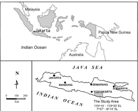
The study area is located in Gunungsewu karst area of Yogyakarta Special Territory, Indonesia, geographically lies of 7o57' - 8o14'
south latitude, and
110o19' - 110o50'
east longitude, about 25 km southeastern of Yogyakarta city. Case study was especially taken in the Ponjong and Karangmojo districts, Gunung Kidul Regency, on the coordinate of 468750mE – 473750mE and 9117000mN – 9122000mN. Fig. 1 shows the location of the study area that can be reached easily by cars from Yogyakarta city.
______________________
Fig. 1. Map showing the location of the study area
2.
Methods of Study
Approach method applied in the study was field surveying, surface geologic and geomorphologic mapping, topographic interpretation, remote sensing, petrologic and geologic structure assessment. Data used for the analyses were derived from field surveys and mapping, and from existing previous studies. Remote sensing method was run by using airphotoes of 1 : 35,000 scale and satellite images (Ers and Google Earth).
Survey and mapping were done to identify variation physical characteristics and distribution of the lithology. Geologic structure identification and measurements were operated for strike and dip and also shape of karst morphology such as hill, ridge, and valleys. Topographic and image interpretation were utilized for determining pattern and orientation of fracture system (joint, fractures, fault) also hills and valleys lineaments.
3.
Geology
Geologic setting of Gunungsewu belongs to western part of Southern Mountains [18]. The stratigraphy from the oldest to the youngest is composed of Semilir
formation, Nglanggran formation, Sambipitu formation, Oya formation, Wonosari formation, Kepek formation, and locally Terrarosa deposit.
Semilir formation belongs to deep sea sedimentary rocks consists of sandstone, tuff, tuffaceous sandstone, lapilli, tuff breccias, lappilli breccias, agglomerate, andesitic breccias, clay stone, siltstone, and shale of Oligocene – Early Miocene [17]. Semilir formation is overlain by Nglanggeran formation, consists of andesitic breccias, agglomerate, polymixed breccias, lava deposits, sandstone and tufaceous sandstone. Age of the formation is oligomiocene to Middle Miocene [17]. Nglanggeran formation is conformably overlain by sambipitu formation that comprises marl, claystone, calcareous siltstone, calcareous sandstone, and tuffaceous sandstone. Sambipitu formation is Middle Miocene age [17]. Oya formation conformably overlays Sambipitu formation. This rock unit consists of calcarenite, bedded limestone, calcareous sandstone, and tuffaceous-calcareous sandstone. Age of the formation is Middle Miocene to Mio-Pliocene [10]. Oya formation is overlain by Wonosari formation that consists of reef, massive and bedded limestones of Middle Miocene to Pliocene age [10]. Kepek formation consists of marl and calcarenite that lays over the Wonosari formation of Pliocene – Pleistocene epoch [10]. The geologic map of the study area is shown in Fig. 2.
Gunungsewu has been uplifted and a little bit folded since middle miocene or about 6 million years ago ([17]). There is a syncline expresses as the Wonosari plateau with axial orientation of N75oE - N255oE,
dipping no more than 10o, while the hills display
homoclinal dipping 5o to 15o relatively southward [9],
[10]. In the Ponjong and Karangmojo areas, dip of the bedding planes reaches 18o.
Fig 2. Geologic map of Gunungsewu area [10]
4.
Karst Geomorphology
According to White (1988), there are some requirements to form such a perfect karst, this include the existence of limestone of >200 m thickness, massive but jointed, and bedded. There must be valleys that the elevation is lower than the position of the limestone. Karstification also needs warm climate, high enough rainfall (>2000 mm/year); and relatively slow tectonic activity (uplifting) involving all of the area.
Beside the requirements mentioned above, morphologic diversity of karst is influenced by physical characteristics of the limestone, including strength and hardness. Joints, cracks, faults, bedding planes are factors that contribute in karstification process (Bogli, 1980), into which dissolution occurs.
All of the Gunungsewu area spreading is about 1500 km2. Based on air photo interpretation, there are more or
Fig 3. Cone karst
Fig 4. Convex cone karst
Fig 5. Dome karst
Fig 6. Ridge karst
5. Influence of Lithologic Variation and Geologic
Structure
Limestone of Wonosari Formation in the Gunungsewu Area is composed of some lithofacieses, such as bedded limestone consist of packstone and wackestone, and reef limestone or boundstone [8],[9],[10]. Beside wackestone, packstone and boundstone, there is also grainstone. The limestone physically shows karstification or hard and cavernous, and calichification (chalky limestone), weak or brittle. If such limestones is uplifted and exposed in the area with wet tropical climate, karstification will happen. But when the limestone is exposed in an arid with a few rainfall condition, calichification will occur. The sequence of caliche consists of hardpan, platty caliche, nodular caliche, and chalky caliche. [15].
In this study, result of geomorphologic and geologic mapping on the distribution and variation of lithology and geologic structure verifies that different physical characteristic of lithology forms different shape of morphology, either positive or negative reliefs. In this case, internal friction angle () of limestone has an important role in producing the slope of morphology of the karst. Table 1 contains various values of internal friction angle of limestone from some sources.
Table 1 Values of internal friction angle (of karstic limestone and caliche, quoted from some sources
Limestone (o) Dolomite, Chalky limestone (o) Source
33 - 40 27 - 31 Hoek & Bray (1981)
35 – 50 22 Jumikis (1983)
34,8 – 42 31,5 – 35,5 Goodman (1989)
32 - 49 30 - 41 Franklin & Dussault (1989)
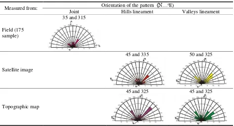
Table 2 Orientations of joint pattern, hills and valleys lineaments
Measured from: Orientation of the pattern (N…oE)
Joint Hills lineament Valleys lineament
Field (175 sample)
35 and 315
Satellite image
45 and 335 50 and 325
Topographic map
45and 325 45 and 325
6.
Karst Geomorphologic Model of
Gunungsewu
Karst geomorphology modeling of the Gunungsewu area refers to Verstappen (1983), comprises some aspecs including morphographic morphometric, and morphogenesis. Morphogenesis involves passive morphostructure, physical properties of the lithology, active morphostructure including tectonic, and morphodynamic. It is also related toexogenic processes such as erosion, dissolution, and mass wasting.
Geomorphologic diversity of Gunungsewu area involves positive and negative reliefs. Positive relief comprises hills of 10 m to 90 m height. The shape varies from conical (angular top cone), dome, rounded top cone (convex-cone), convex, and ridge. While negative reliefs includes doline, uvala, polje, and shaft, or cave.
Attractive morphology is not only found on the surface, but also in subsurface or in caves. There are various ornaments such as stalactite, stalagmite, pilar, sinter, and flowstones. The formation of endokarst in the caves are also influenced by the existence of fracture structures and bedding planes. The stalactites are always found in longitudinal raw following strike of fractures that is crosscutting the wall or roof of the cave.
Table 3 and Table 4 describe the model of karst morphology of Gunungsewu area. As already discussed above, it is controlled by variation of physical properties of the lithology and the existence of geologic structures.
Conclusions
1. Karst morphology of Gunungsewu area can be grouped into morphology with positive relief including hills of cone, convex-cone, dome, convex, and ridge shapes, and morphology with negative relief such as cave, shaft, doline, uvala, locva, and polje
2. The variation of karst morphology of Gunungsewu area is influenced by the variation of physical properties of the lithology such as hardness and internal friction angle, and geologic structures such as joint orientation, and existence, position, thickness of bedding plane.
3. Karstic limestone either massive or bedded forms hills of cone, convex-cone, and dome shaped, while caliche limestone displays convex hills. Internal friction angle (of the lithology determines the angle of slope inclination of the hills that are formed. The higher the value of friction angle (, the steeper the slope of hills which are formed. 4. Joint, crack, and fault patterns are correlated to the horizontal bedding plane will result dome, convex, and ridge shapes.
5. Cave, shaft, doline, and uvala are only formed in karstic limestone, while polje can be found either in karstic or caliche limestone.
Acknowledgment
Gratefulness is dedicated to the Institute of Research and Community Service, UPN “Veteran” Yogyakarta for its support to this successful study.
References
[1] Bogli, A., 1980, Karst Hydrology and Physical Speleology, Springer-Verlag, 284 p.
[2] Dunham, R. J., 1962, Classification of Carbonate Rocks According to Depositional Texture. In: W.E. Ham (Ed), Classification of Carbonate Rocks. AAPG Mem. 1, p 108 – 121.
[3] Esteban, M., 1996, Karst System from Prospect to Reservoir, Carbonate International Ltd, 168 p. [4] Franklin, J.A. & Dussault M.B., 1989, Rock
Engineering, McGraw Hill Publishing Company, 600 p.
[5] Goodman, R.E., 1989, Introduction to Rock Mechanics, 2nd ed, John Wiley & Sons, 56 p. [6] Hoek E & Bray J.W., 1981, Rock Slope
Engineering, Revised 3rd ed, The Institution of
Mining and Metallurgy London, 358 p.
[7] Jumikis, A.R, 1983, Rock Mechanics, nd ed, Gulf Publishing Company, 613 p.
[8] Kusumayudha, S.B., Zen, M.T., Notosiswoyo S., Gautama R.S., 1997, Study on the distribution of carbonate rocks based on fractal characteristics of the valley patterns and secondary porosity, case:
[10] Kusumayudha, S. B., 2004, Introduction of Karst Hydrogeology, Pusat Studi Karst UPN “Veteran” Yogyakarta, 137 p.
[11] Kusumayudha, S.B., 2005, Fractal geometry and hydrogeology of Gunungsewu Area, Adicita Publisher, Yogyakarta, 171 p.
[12] Kusumayudha S.B., 2008, Karst: cave, underground river, and spring, Citra Aji Parama Publisher, Yogyakarta, 44 p.
[13] Kusumayudha, S. B., 2011, Exploring the Prospective of Gunungsewu Area for a World Geopark, Malaysia – Indonesia Join Geoheritage Convention, 1 – 2 Oktober 2011, Terengganu, Malaysia
[14] Monroe, W.H., 1976, The Karst Landforms of Puerto Rico, United State Government Printing Office, 69 p.
[15] Moore, C.H., 1989, Carbonate Diagenesis and Porosity, Elsevier, 338 p.
[16] Setiawan, J. & Kusumayudha, S.B., 2011, Groundwater system of Gunung Kendil and Umbul Ponjong as a unique geoheritage, Malaysia
– Indonesia Join Geoheritage Convention, 1 – 2 Oktober 2011, Terengganu, Malaysia
[17] Suyoto, 1994, Stratigraphic sequence of the Geomorphology, Elsevier Science Publishers, 437 p.
Table 3 Model of the influence of lithologic physical properties and geologic structures to positive relief karst morphology
MORPHOLOGY MORPHOGENESIS
LITHOLOGY Morphographic Morphometric
Active Morphostructure
- Relatively top sharp - Height: 30 – 90 m
- Joint
- Thin bedded: < 1m - Bedding plane
inclination: > 5o
hard, cavernous, lapies, = 32 – 50
- Massive or bedded - Relatively horizontal
bedding plane: < 5o
hard, cavernous, lapies, = 32 – 50
bedding plane: < 5o
weak, chalky,
- Moderately inclined to
steep slope
Table 4 Model of the influence of lithologic physical properties and geologic structures to negative relief karst morphology
MORPHOLOGY MORPHOGENESIS
LITHOLOGY Morphographic Morphometric
Active Morphostructure
- Various height, reaching
30 m
- Various width, reaching
50 m
-Joint
-Massive or bedded -Incline to horizontal
bedding plane
hard, cavernous, lapies, = 32 – 50
-Gently incline to
horizontal bedded plane : <5o
hard, cavernous, lapies, = 32 – 50
-Massive of bedded -Incline bedding plane:
>5o
hard, cavernous, lapies, = 32 – 50
Karstification
Bedded limestone
Caliche limestone
Polje
- Moderately inclined to
steep slope
![Fig 2. Geologic map of Gunungsewu area [10]](https://thumb-ap.123doks.com/thumbv2/123dok/1648208.2069939/6.612.60.557.55.451/fig-geologic-map-gunungsewu-area.webp)