AND
R
EQUEST FOR
Q
UOTATION
&
C
ALL FOR
P
ARTICIPATION
FOR THE
A
RCTIC
S
PATIAL
D
ATA
P
ILOT
P
HASE
2
1
Introduction ... 3
1.1 OGC Reference Model ... 3
1.2 OGC Standards Baseline ... 3
1.3 Data ... 4
1.4 Services in the Cloud ... 4
2
Technical Architecture ... 4
2.1 ArcticSDP Architecture ... 4
2.2 ArcticSDP Components ... 5
3
Deliverables ... 8
3.1 Documents ... 8
3.2 Implementations ... 8
3.3 Work Items ... 9
4
Final Demonstration ... 10
1
I
NTRODUCTION
This Annex B provides background information on the OGC baseline, describes the ArcticSDP architecture, and identifies all work items. For general information on ArcticSDP, including deadlines, funding requirements and opportunities, please be referred to the ArcticSDP RFQ Main Body, which is available on the OGC ArcticSDP Web site.
1.1
OGC
R
EFERENCEM
ODELThe OGC Reference Model (ORM) version 2.1, document OGC 08-062r7, provides an architecture framework for the ongoing work of the OGC. Further, the ORM provides a framework for the OGC Standards Baseline. The OGC Standards Baseline consists of the member-approved Implementation/Abstract Specifications as well as for a number of candidate specifications that are currently in progress.
The structure of the ORM is based on the Reference Model for Open Distributed Processing (RM-ODP), also identified as ISO 10746. This is a multi-dimensional approach well suited to describing complex information systems.
The ORM is a living document that is revised on a regular basis to continually and accurately reflect the ongoing work of the Consortium. We encourage respondents to this RFQ to learn and understand the concepts that are presented in the ORM.
1.2
OGC
S
TANDARDSB
ASELINEThe OGC Standards Baseline is the currently approved set of OGC standards and other approved supporting documents, such as the OGC abstract specifications and Best Practice Documents. OGC also maintains other documents relevant to the Interoperability Program including Engineering Reports, Discussion Papers, and White Papers.
OGC standards are technical documents that detail interfaces or encodings. Software developers use these documents to build open interfaces and encodings into their products and services. These standards are the main "products" of the Open Geospatial Consortium and have been developed by the membership to address specific interoperability challenges. Ideally, when OGC standards are implemented in products or online services by two different software engineers working independently, the resulting components plug and play, that is, they work together without further debugging. OGC standards and supporting documents are available to the public at no cost. OGC Web Services (OWS) are OGC standards created for use in World Wide Web applications. For this pilot, it is emphasized that all OGC members have access to the latest versions of all standards. If not otherwise agreed with the testbed architects, these shall be used.
The OGC Testing Facility web page provides online executable tests for some OGC standards. The facility helps organizations better implement service interfaces, encodings and clients that adhere to OGC standards.
1.3
D
ATAAll pilot participants are encouraged to provide data that can used to implement the use cases that will be developed during the pilot. Sponsors will provide data, but it might be necessary to complement these with additional data sets. Please provide detailed information if you plan to contribute data to this pilot.
1.4
S
ERVICES IN THEC
LOUDPilot participants are encouraged to provide data or services hosted in the cloud.
2
T
ECHNICAL
A
RCHITECTURE
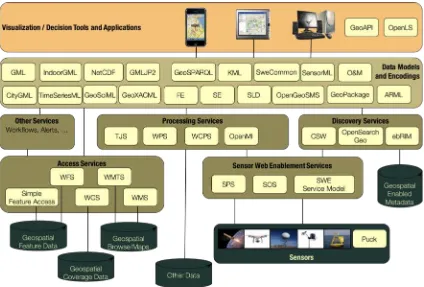
The goal of this pilot is to demonstrate the diversity, richness and value of SDI data-rich Web services to Arctic stakeholders for subsequent implementations and to influence Arctic Council information management practices. To achieve this goal, this pilot will implement a loosely confederated Spatial Data Infrastructure as described in phase-1 report, section 5.2.3 with focus “on infrastructures, platforms, and geoportals as they currently exist and emphasizes their integration into a loose confederation“, that allows clients to discover and accesses data via standardized open Web service interfaces.
2.1
A
RCTICSDP
A
RCHITECTUREFIGURE 1: ARCTICSDP ARCHITECTURE, SOURCE: OGC
An SDI based on this architectural approach allows an entirely decoupled and loosely federated infrastructure with minimized necessary a-priori knowledge required to interact with the various components.
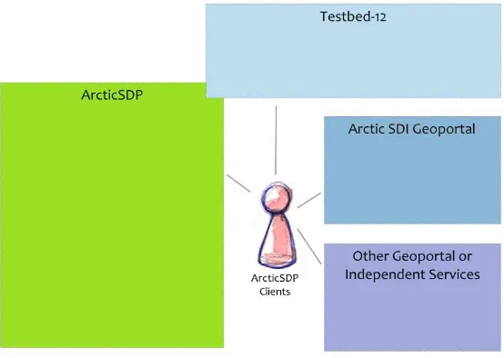
2.2
A
RCTICSDP
C
OMPONENTSThe components developed in this pilot (see section Deliverables for details) will interact with external Web services and Web portals such as the Arctic SDI1 as well as components made available as part of the OGC Testbed-12 initiative or other geoportals and independent Web services. The components implemented in this pilot shall be loaded with data provided by Sponsors and pilot participants.
The following figure provides a high-level overview of the envisioned interactions between ArcticSDP, Testbed-12, and externally provided resources.
FIGURE 2: ARCTICSDP INTERACTIONS
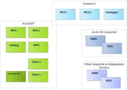
The ArcticSDP components shall provide for the key aspects of data discovery, data access and exploration, as well as data visualization and representation to meet this pilot’s goals and objectives. To achieve this goal, ArcticSDP client applications need to interact with ArcticSDP Web service components as well as externally provided resources. To acknowledge the particular Internet availability situation in the Arctic, at least one of the client applications of the ArcticSDP shall support GeoPackage handling. The following figure 2 provides a more detailed component view of figure 1 above, providing information on ArcticSDP and Testbed-12 components as well as externally provided services.
FIGURE 3: WORK ITEMS AND COMPONENTS VIEW OF THE ARCTICSDP
The following work items and components are part of the ArcticSDP:
Two Web Feature Service (WFS,version 2.0 or higher) instances that need to be loaded with data made available by Sponsors and pilot participants to make data available.
A Catalog Service Web (CSW version 2.0 or higher) that registers all data sources and services used in this pilot as well as externally provided Arctic data available at OGC standards compliant Web services.
A Web Processing Service (WPS, version 2.0) instance to create GeoPackages from data provided at Web Map Service (WMS), Web Coverage Service (WCS), or Web Feature Service (WFS) interfaces.
Two Client implementations that will be used in the demonstration use cases to interact with catalogs, data services, and mapping services. At least one client shall support GeoPackages. GeoPackage handling includes loading GeoPackages from a resource identified by a Catalog service, the visualization of the data, and the update of the GeoPackage content in an offline situation.
Report shall be developed in cooperation with the Arctic ER developed as part of Testbed-12. All pilot participants are required to support the development of the engineering report.
The following externally provided components shall be used by ArcticSDP clients to implement the use cases defined in Annex A:
Testbed-12 Two WCS providing access to Arctic coverage data
Catalog service CSW with services and data resources registered that are relevant for ArcticSDP
Arctic SDI Geoportal The Arctic SDI provides a portfolio of WMS services. These shall be used as part of the use case implementations. Additional services may be used as available
Other Geoportal or Independent Services
OGC standards compliant Web services as provided by third parties necessary to or available to enrich the ArcticSDP use cases
3
D
ELIVERABLES
ArcticSDP requires two types of deliverables: documents and implementations. All pilot participants are required to support the final demonstration by analyzing existing portals serving Arctic data for usability within the demonstration scenario and for registration in the Arctic data and OGC compliant Web service inventory.
3.1
D
OCUMENTSpilot for integration and interoperability testing in support of the agreed-up demonstration use cases and technical architecture.
3.3
W
ORKI
TEMSThe work items and deliverables for this project are identified in the following tables. The deliverable IDs provided in these tables shall be used to reference deliverables in RFQ responses and cost-sharing spreadsheets. The names of the various deliverables are printed in bold.
TABLE 1, ARCTIC SPATIAL DATA PILOT DOCUMENTATION DELIVERABLES
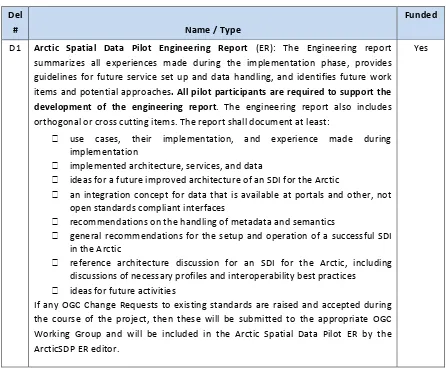
Del
# Name / Type
Funded
D1 Arctic Spatial Data Pilot Engineering Report (ER): The Engineering report summarizes all experiences made during the implementation phase, provides guidelines for future service set up and data handling, and identifies future work items and potential approaches. All pilot participants are required to support the development of the engineering report. The engineering report also includes orthogonal or cross cutting items. The report shall document at least:
use cases, their implementation, and experience made during implementation
implemented architecture, services, and data
ideas for a future improved architecture of an SDI for the Arctic
an integration concept for data that is available at portals and other, not open standards compliant interfaces
recommendations on the handling of metadata and semantics
general recommendations for the setup and operation of a successful SDI in the Arctic
reference architecture discussion for an SDI for the Arctic, including discussions of necessary profiles and interoperability best practices
ideas for future activities
If any OGC Change Requests to existing standards are raised and accepted during the course of the project, then these will be submitted to the appropriate OGC Working Group and will be included in the Arctic Spatial Data Pilot ER by the ArcticSDP ER editor.
TABLE 2, ARCTIC SPATIAL DATA PILOT COMPONENT DELIVERABLES
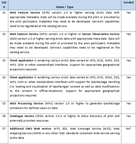
Del
# Name / Type
Funded
C1 Web Feature Service (WFS) version 2.0 or higher serving Arctic data with appropriate metadata. Data will be made available during the pilot or provided by the pilot participant; metadata may need to be developed. Service’s capabilities need to be registered at the catalog service.
Yes
C2 Web Feature Service (WFS) version 2.0 or higher or Sensor Observation Service
(SOS) version 2.0 or higher serving Arctic data with appropriate meta data. Data will be made available during the pilot or provided by the pilot participant; metadata may need to be developed. Service’s capabilities need to be registered at the catalog service.
Yes
C3 Client application 1 rendering various Arctic data served at WFS, WCS, WMS, SOS, WPS, CSW or other standardized interfaces. Support for appropriate geographical projections required.
Yes
C4 Client application 2 rendering various Arctic data served at WFS, WCS, WMS, SOS, WPS, CSW or other standardized interfaces with support for GeoPackage handling (i.e. loading and visualization of GeoPackges’ content as well as data modifications to the content in offline-situations). Support for appropriate geographical projections required. Mapping Service (WMS) or any other OGC standards compliant Web service serving Arctic data
SDI, can be efficiently combined and integrated with Web services set up as part of this pilot, and
the two use cases have been implemented including all communication and interaction between client, catalogues, and data services.
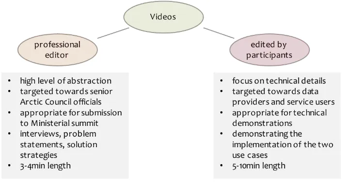
All videos are produced by OGC. Participants of this pilot are required to contribute to the final demonstration, which is the basis for video productions. All videos belong to one of the two groups described in the figure below. Examples of professionally edited videos are available here (short version) and here (long version).
FIGURE 4: DIFFERENT TYPES OF VIDEOS
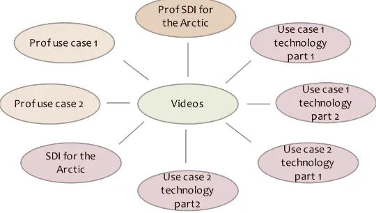
The series of videos shall implement a number of thematic aspects. Ideally, the pilot should generate three professionally edited videos that address: (i) the overall situation of geospatial data in the Arctic served at standardized interfaces, (ii) particular experiences made during use case 1 implementation, and (iii) particular experiences made during use case 2 implementation. Currently, funding has been made available for only one professionally edited video. If additional funding can be found, the professional videos 2 and 3 will be produced. For that reason, the list of work items is extended here with the two following items. Both are currently unfunded.
D2 Professional video 2 (implementation of use case 1) as documented in Figure 4: Different types of videos
No*
D3 Professional video 3 (implementation of use case 2) as documented in Figure 4: Different types of videos
No*
* We welcome fully in-kind proposals and we are seeking additional sponsorship to fund these deliverables.
technical details or experiences made while implementing use cases 1 and 2 as well as illustrating SDI for the Arctic from a more technical, hands-on perspective. The following figure provides an overview of the targeted videos.