VALORISATION OF CULTURAL HERITAGE THROUGH VIRTUAL VISIT AND
AUGMENTED REALITY: THE CASE OF THE ABBEY OF EPAU (FRANCE)
E. Simonetto a, *, C. Froment a, E. Labergerie a, G. Ferré a, B. Séchet b, H. Chédorge b, J. Cali a, L. Polidori a
a
ESGT, L2G, Campus Universitaire, 72000 Le Mans, France – [email protected], (elisabeth.simonetto,
eric.labergerie, ghyslain.ferre, jose.cali, laurent.polidori)@esgt.cnam.fr
b
Servive Patrimoine et Politiques Territoriales, Conseil Général de la Sarthe, rue Joinville, 72000 Le Mans, France –
[email protected], [email protected]
Commission
KEY WORDS: Cultural heritage, Terrestrial Laser Scanning, Three-dimensional modeling, Virtual reality, Augmented reality, Internet/Web
ABSTRACT:
Terrestrial Laser Scanning (TLS), 3-D modeling and its Web visualization are the three key steps needed to perform storage and grant-free and wide access to cultural heritage, as highlighted in many recent examples. The goal of this study is to set up 3-D Web resources for “virtually” visiting the exterior of the Abbaye de l’Epau, an old French abbey which has both a rich history and delicate architecture. The virtuality is considered in two ways: the flowing navigation in a virtual reality environment around the abbey and a game activity using augmented reality. First of all, the data acquisition consists in GPS and tacheometry survey, terrestrial laser scanning and photography acquisition. After data pre-processing, the meshed and textured 3-D model is generated using 3-D Reshaper commercial software. The virtual reality visit and augmented reality animation are then created using Unity software. This work shows the interest of such tools in bringing out the regional cultural heritage and making it attractive to the public.
* Corresponding author.
1. INTRODUCTION
1.1 Objectives
Terrestrial Laser Scanning (TLS), 3-D modeling and Web sharing are the three key steps needed to perform storage and free and wide access to cultural heritage. This has been underlined by many recent examples in various contexts, be they artistic heritage (Abate et al., 2011), archaeology (Meyer et al., 2006; Agugiaro et al., 2011, Alby et al., 2011, Appolonio et al., 2011, Koehl and Brigand, 2012), architectural (Mancera-Taboada et al., 2011, Guarnieri et al., 2010, Boeykens, 2011), and even industrial (Rojas-Sola and Castro-Garcia, 2011). The goal of this study is to set up 3-D resources for “virtually” exploring the exterior parts of the Abbaye de l’Epau (Figure 1), an old French abbey which has both a rich history and delicate architecture. This building has belonged to the French historical monuments inventory since 1961, which means that it is placed under specific legal provisions.
1.2 Monument history
The abbey of “Pitié Dieu” in l’Epau (CG72_1; CG72_2; Bouton et al., 1999), known as the Abbaye de l’ Epau, is located in Yvré l’Evêque, near Le Mans, the main city of the department of the Sarthe in France. It is a former Cistercian abbey founded in 1229 by Queen Berengaria of Navarre, daughter of Sanche VI, King of Navarre, and widow of King Richard the Lionheart. Berengaria died one year later as the first Cistercian monks settled. The building was extended until 1365 – during the Hundred Years’ War – when the inhabitants of Le Mans burned the abbey down.
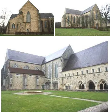
Figure 1. Abbey of Epau: Top: two views of theabbey-church. Bottom: cloister square.
After stages of reconstruction and extension, the domain was eventually sold in the eighteenth century, becoming an industrial and agricultural facility. Thus, it was subjected to extensive damage. The Conseil Général (General Council) of the department of the Sarthe (CG72) acquired the site in 1959.
CG72 has carried out major renovation works over fifty years to revive the main architectural features of the thirteenth and fourteenth centuries. Work to integrate conveniences has been undertaken, which has improved the functionality of the building and made it suitable for holding public events. Today, the plenary sessions of the departmental council are held at the abbey as well as numerous annual cultural events that highlight the departmental territory: a classical music festival in the spring, many concerts such as the Europa Jazz festival, a cycle of exhibitions in the summer and meetings and one-off events.
1.3 A short description of the monument
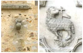
During its history, the abbey has undergone changes related to damage, reconstruction work, building extension or improvements. Today, it is made up of nine main parts: Eglise Abbatiale (abbey-church) (Figure 1), Sacristie (sacristy), Salle Capitulaire (chapter house) with the recumbent figure of Queen Berengaria (Figure 2), Dortoir (dormitory), Chauffoir (heating room), Réfectoire (refectory and former kitchen), Logis de l’Abbé (abbot’s lodging), and Cloître (cloister square) (Figure 1). The last part is a small building located approximately 100 m away, called the Cellier (storeroom), since it probably served as a pantry. The abbey-church is positioned in an east-west direction as recommended by the architectural Cistercian Order. Its length is about 150 m. The north-south transept, that is about 160 m long, continues with the sacristy, the chapter house and the dormitory, with a total length of 120 m. The following parts are at right angles (in an east-west direction) and stretch over 120 m. The former rooms are on the second floor. Between the chapter house and the Scriptorium (a part of the dormitory), a passage, called the Passage Charretier, connects the cloister to the eastern side of the abbey. The abbot’s lodgings, that are about 80 m long, is built from the southern tip of the dormitory at right angles. The cloister square is about 120 m side and is located at the center of this structure towards the west. However, only sandstone hooks and a dripstone along walls still attest its existence (Figure 3). Mainly sandstone, limestone and wood for frame and paneling were used to construct the building. Each part is of great relevance from a historical and architectural point of view (Bouton et al., 1999). Indeed, apart from the various shapes of the rooms and the different types of ceiling, many details are particularly important, among them: keystones, sculptures of importance (Figure 3), arches and paints.
1.4 Work issues
CG72 has expressed its interest for the storage of its cultural heritage and the 3-D modeling with a view to different objectives. In the first place, is the use of a 3-D model as a scenographic tool to preview events and exhibitions. Various possible setups can be simulated and the most appropriate one picked up. The digital model would also be useful at an early stage of renovation works to visualize future modifications before they are actually implemented.
Next, is the valorization and ease of access for the greatest number of people. The digital mockup should allow the public to discover the monument and/or to prepare a visit. Comfortably seated in front of their computer, internet users could explore the outside of the abbey before entering to gaze at its rooms and architecture. This virtual tour can offer a significant advantage over the real one, since it could encroach on areas that are generally not accessible to the public. Besides, augmented reality games could make the real visit more attractive and educational.
Figure 2. chapter house and recumbent figure of the Queen Berengaria.
Figure 3. On the left: hook and dripstone as evidence of the former cloister. On the right: the monastery’s emblem.
1.5 Content
This work aims to create the virtual mockup of the exteriors of the Abbey with a view to two uses: a virtual Web visit and a game using augmented reality (AR). It includes several steps: data acquisition and pre-processing (presented in part 2), the generation of a 3-D model (part 3), the creation of the virtual visit and its posting on the Web (discussed in part 4) and the production of the AR animation.
2. DATA ACQUISITION AND PROCESSING
2.1 Context
Data acquisition is the first key step leading to a textured 3-D model of the monument. A good rendering quality could be desired but it should be related to requirements. The professionals in charge of the site wish to recreate the original building with the greatest possible precision and level of detail (LoD). The user is less interested in geometrical precision and more in the aestheticism of the product (texture, lightning, shadows, etc). Indeed, the flowing of VR/AR applications will be limited by hardware and software performance when considering a large amount of data. A compromise between high precision/LoD and flowing/aestheticism of the final products is required. In this context, it is decided to acquire a large amount of data with high geometrical precision and LoD for storage or future uses. The data will be partly debased in the public applications. Four kinds of survey have been carried out:
GPS (Global Positioning System), tacheometry, TLS and digital camera.
2.2 The GPS and tacheometry surveys
Thirty-four GPS points were measured using LEICA GPS 500 instruments placed on tripods. Three instruments were available and two methods were used: the static survey and the rapid static survey. The first one was of interest when long baselines occurred, and the second was used when points were close to each other (here about 150 m maximum). One dual frequency GPS receiver was put on the ground as a master station taking its GPS measurement in static mode for the rapid static survey. Its position was determined by differential phase GPS measurements from one or several surrounding GPS stations that belong to the French GPS station network which is known as RGP. Tacheometry was used to localize targets in the chapter house. The georeferencing is based on the French geodetic reference system RGF93 and the coordinates are derived in the national map grid using the Lambert-93 map projection (conformal conic projection using the GRS80 ellipsoid). After GPS post-processing, the final 3-D uncertainty of these points is less than 5 cm.
2.3 The TLS survey
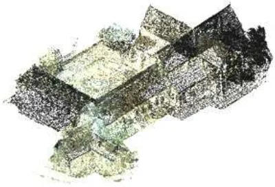
The point cloud was acquired during three measurement campaigns totaling eight days (Figure 4). The first was dedicated to surveying a part of the abbey-church, the second dealt with the east and south facades and the chapter house and the last dealt with the Passage Charretier, the cloister square, surrounding walls at the west side of the cloister and details such as arches, sculptures and rosette acquired using a finer spatial sampling.
In the first measurement campaign, the TLS survey was carried out using the Leica HDS 6000 which makes use of the phase-shift distance principle. According to the constructor, the scanner range reaches 79 m at a 90% albedo. Its position accuracy is 6 mm for a range of 25 m. The scan rate reaches 500 000 points per second. The wavelength is 670nm. For the other missions, a phase-based scanner was also used: a Leica ScanStation C10. The range reaches 300 m at a 90% albedo. Its position accuracy is 6 mm for a range of 50 m. Its acquisition speed reaches 50 000 points per second. The wavelength is 532 nm. This system is fitted out with a camera that acquires 4 megapixels per image.
The acquisition was carried out using different spatial samplings: 5 cm x 5 cm at a distance of 100 m over the whole monument and 2 mm x 2 mm over details. A total number of 55 stations were required. The point clouds have a total number of about 240 million points.
The point clouds were registered using georeferenced and non-georeferenced targets (Figure 5). The first ones were on tripods and correspond to the 34 GPS point locations. The second type of target was placed on the floor or walls. Leica Geosystems HDS 6" planar circular targets – both blue&white and black&white – were used. The target registration errors were less than 5 mm. After registering all the scans, the whole point could of the abbey was georeferenced using the GPS targets. The georeferencing accuracy depends on that of the GPS one (planimetric and height): about 5 cm RMS. As a prerequisite, the point cloud is cleaned up before working on it. This is semi-automatically performed thanks to Leica Cyclone v.7.3 software from Leica Geosystems. Thus, points relative to some targets, tripods, some trees and other surrounding points are deleted (Figure 6).
Figure 4. TLS acquisition plane during the three campaigns, superimposed on an aerial view (IGN BD Ortho®).
Figure 5. The third TLS campaign: laser stations and target (GPS and non georeferenced) locations.
Figure 6. Georeferenced point cloud.
2.4 Photography acquisition
Many photographs were used for texture mapping. They were taken as perpendicular as possible to each surface. Three cameras were used: Canon EOS 1000D (the image size is 3888
x 2592 pixels), Canon EOS 5D Mark II (5616 x 3744 pixels) and Sony DSC-R1 (2160 x 1440 pixels). These cameras enable the setting of the depth of field, the ISO sensitivity and the shutter speed in order to improve luminosity, contrast and level of details.
3. 3-D MODELLING
3.1 Data preparation
The point cloud is exported in two ways: a first point cloud with a debased spatial sampling of 10 cm and several point clouds without change of the spatial sampling. The first one will be used to produce a coarse mesh and totals more than 15 million points. The other point clouds will be introduced to correct the defects in the first mesh. We made a cut out into 10 clouds so that every cloud has a maximum number of about 55 million points. This figure depends on hardware performance. Indeed, our strategy is to produce a first coarse mesh and then improve it part by part with each sub-cloud. This resolves the hardware limitations to process the whole point cloud at one go.
3.2 3-D modelling
We generate the meshed model using commercial software (3-D Reshaper ® from Technodigit-Hexagon Metrology). Five steps are conducted:
1. Meshing of the debased point cloud: it is carried out by the software using a regular spatial sampling between points. The averaged distance between points in the mesh is set to 30 cm. Holes larger than about 60 cm are automatically detected and filled. After meshing, aberrant triangles are manually deleted. They mainly occurred under the building between low points away from one other. Finally, larger holes related to occluded areas (for instance under the gutters) are manually filled.
2. Filtering of the coarse mesh to remove the remaining tripods, trees or any other undesirable elements. This step is done manually by selecting and deleting sets of triangles.
3. Refinement of the coarse mesh using the 10 point clouds. For each part, we can superimpose the existing mesh and a point cloud and compute a new mesh. During this step, the software algorithm dismisses the aberrant points – points that are at least 10 cm or 20 cm away from the surface – and builds new triangles while authorizing small displacements of the points so as to obtain the most appropriate positions. This is done by measuring the distance between a point and the triangle faces; this is called the chord error. This error must be under a certain threshold. In our case, it is set to 1 mm. Besides, the refined mesh is limited to 500 000 triangles. The outer borders of each part are not modified. As a consequence, the merging of the refined parts does not show any connection defects.
4. Improvement of the refined mesh. It is necessary to improve many edges and to fill remaining holes. This is locally carried out using various approaches: drawing of polylines and constrained meshing with sharp corners, refined meshing using the chord error. 5. Mesh simplification: it consists in merging the
triangles corresponding to flat surfaces. This is done by selecting a set of triangles and merging them according to a reduction rate.
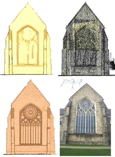
After step 2, the coarse mesh has about 185 000 points and 370 000 triangles. We obtain more than 4 million triangles in the final mesh (Figure 7).
Figure 7. Example of results over a side of the abbey-church. Coarse mesh (at the top left). Superimposition of the debased point cloud and the complete one over the rosette (at the top right). Refined mesh (at the bottom left). Texture image (at the
bottom right).
3.3 Model texturing
The main difficulty of this step is to manage a compromise between the size of the meshed and textured 3-D model and the preservation of the image quality. We choose to debase all images using JPEG compression so that the size of the compressed images is about 500 Ko. The advantage of this processing is that the rendering quality could be preserved while saving memory space. However, this choice is heuristic and depends on hardware and software performance. Each surface is textured using one or several images. The mapping relies on the manual tie point selection between an image and the mesh (Figure 8). Image overlay is managed owing to software functionalities. Indeed, we can manually rub out an undesirable texture and select the right one.
4. VIRTUAL REALITY AND AUGMENTED REALITY OF ABBEY’S EXTERIORS
4.1 Related works
Virtual reality (VR) implies full immersion in the digital environment. In our case, a virtual visit is proposed on the desktop. Two main approaches exist. In the first one, the model is downloaded by the client in a specific format and it is visualized in standalone mode using an adapted viewer. In the
Figure 8. Textured mesh over the rosette of the abbey-church using the refined mesh and the texture image from Figure 7.
second approach, the model is not downloaded on the local device; navigation is possible using a Web browser and a plugin. Typically, VRML (Virtual Reality Mark Up Language), and more recently X3D, are standard file format for 3-D model display, associated with viewers such as Cosmo Player, OpenVRML or FreeWRL (Meyer et al., 2006; Guarnieri et al., 2010). GoogleEarth is also used in some works as a Web player (Wells et al., 2010; Appolonio et al. 2011). The second strategy is preferred for two main reasons: easiness for the remote user and preservation of the data property.
The technical solution is commonly leveraged by video games based on graphic engines, relying on Direct3D, OpenGL or more recently WebGL. Thus, software exists for 3-D data viewing and manipulation, but not all are appropriate for interactive immersion (that is to say, the internet user can move in the virtual environment using a mouse, the keyboard or a touchscreen). Possible software is commercial, such as Unity (UNITY, 2013), or free, such as Blender (BLENDER, 2013). Our work is based on Unity. Moreover, this software was preferred in (Pauwels et al., 2011), where a recent comparison of game engine software in the context of architectural, engineering and construction domains is proposed.
Unity is developed in C/C++ languages and relies on Direct3D, OpenGL, OpenGL ES and proprietary API, depending on the programming platform. The regular version is a free download. It can be used to develop a virtual visit for a desktop in standalone mode or on the Web, using a specific plugin for browser rendering. It also supports the deployment on mobile devices and consoles. The implementation is straightforward with Unity. This software has already been used in the archaeological domain, for instance (Agugiaro et al., 2011). Otherwise, augmented reality offers another way of discovering the abbey. According to (Thomas, 2012), AR is defined as “the registration of computer-generated graphical information over a user’s view of the physical world”. For instance, AR has already been used to enrich a museum visit (Bationo-Tillon et al., 2010). For such an application, Unity contains scripts of Vuforia AR Extension for Unity, developed by QUALCOMM Austria Research Center. They are aiming at building vision-based AR application for Android and iOS (VUFORIA, 2013). These scripts are mainly written in C-Sharp and Visual Basic languages.
4.2 Virtual tour
Firstly, the 3-D model is exported in a standard format. Among the numerous possible formats (Thomas, 2012), we use the obj open file format proposed by Wavefront Technologies Inc. According to (Thomas, 2012), the obj format is able to preserve geometry, appearance (and so image texture) and scene groups.
After import into Unity, the model is described in several elements. Each element corresponds to one single texture image, but it was necessary to manually update the texture image file for each element to restore the texturing. Then the texture mapping is automatic, that is, the camera information was not lost.
An artificial environment is created with predefined components using Unity; it includes a ground, trees and sky. The abbey 3-D model is imported and texturing is restored. In the future, the rendering will be improved by adding the real DEM (Digital Elevation Model) with the real locations of the trees. Indeed, a land survey and the surveying of each tree around the abbey have already been carried out and processed. Next, the abbey 3-D model will be embedded into the DEM while preserving smooth connecting borders (Agugiaro and Kolbe, 2009).
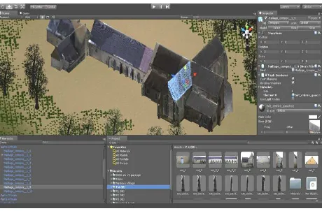
Then, a user camera is defined, which allows the displacement in the mockup. We limit the movement so that the user cannot go outside the defined box, too close to or through the walls. The last step is Web posting. For this purpose, the software proposes different exports. We export our visit to Web player. In this way, the virtual visit can be launched from any computer using an internet navigator and the related Unity plugin (Figure 9).
Figure 9. Virtual reality from Unity.
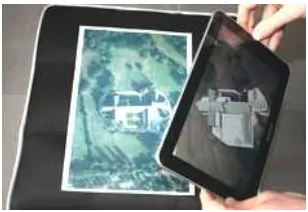
4.3 Augmented reality
Our second proposal is the embedding of the abbey 3-D model in a photograph taken by a user. The user utilizes his own mobile platform. The creation of this application requires the 3-D model and one background image. We take an aerial view (from IGN BDOrtho®) of the abbey as a background image. Using Unity and VUFORIA scripts, the 3-D model is manually positioned at the right place over the image. A light source is added to produce shadow effects. The product is exported for an Android operating system while a tablet computer is connected to the work station. In this way, an application is created and could be copied onto any touchscreen mobile device with an Android operating system.
Firstly, the application requires the reproduction of the background image on paper and made available to the user. Then, the user can fly over the copy thanks to the camera that is fitted to the mobile device, and the 3-D model appears in real time at the right place on the screen (Figure 10).
The correct running of this application depends on the quality of the background image, in terms of sharpness, luminosity and contrast. Indeed, the quality of real time 3-D model positioning relies on the correct matching of tie points between the image of the copy, taken by the camera, and that of the application.
Figure 10. Play activity based on AR.
5. CONCLUSIONS AND OUTLOOKS
Our work leads to first products of game activities so as to discover the abbey of Epau in the Sarthe in France: a virtual tour using a desktop and animation based on augmented reality using a mobile device. Both enable the discovery of the monument in an easy, pleasant and user-friendly way. The project will continue to enrich these applications in terms of quality and educational purposes.
Firstly, the rendering of the virtual visit will be improved by adding the real DEM with trees. Secondly, to increase the moving fluidity while maintaining high rendering quality, we will concentrate on the management of LoD and existing mapping solutions. Besides, the model will be completed by the addition of the inner parts of the building. The passage between the outer and inner parts should remain fluid, despite the amount of data being larger. In this framework, one solution could be that the user would be able to interactively “remove” a roof, revealing the inner room. Finally, an important task concerns the interactivity between the user and the virtual visit or the AR application. This interactivity will aim at adding educational content. The principle is that one could select a flag that appears in the model and visualize corresponding historical or architectural information, in the form of text, image, audio or video. This work will include the creation of the database and the flag embedding interface, the development of the connection between the database and the virtual model and the creation of an adapted Web interface.
6. REFERENCES
References from Journals:
Agugiaro, G., and Kolbe, T.H., 2009. Embedding of high resolution models into a low(er) resolution digital elevation model. DGPF, 18, pp. 217-226.
Guarnieri, A., Pirotti, F., Vettore, A., 2010. Cultural heritage interactive 3D models on the Web: An approach using open source and free software. Journal of Cultural Heritage, 11, pp. 350-353.
Pauwels, P., De Meyer, R., Van Campenhout, J., 2011. Linking a game engine environment to architectural information on the semantic web. Journal of Civil Engineering and Architecture, 5 (9), pp. 787-798.
Rojas-Sola, J. I., Castro-Garcia, M., 2011. Overview of the treatment of historical industrial heritage in engineering graphics. Scientific Research and Essays, 6 (33), pp. 6717-6729.
Thomas, B. H., 2012. A survey of visual, mixed, and augmented reality gaming. ACM Computers in Entertainment, 10 (3), pp. 1-33.
References from Books:
Bouton, E., Kervella, G., Niaussat, M., 1999. L’Epau – L’Abbaye d’une reine. Ed. de la Reinette.
References from Other Literature:
Abate, D., Furini, G., Migliori, S., Pierattini, S.., 2011. Multiple visualization Web approach for cultural heritage objects. In:
CIPA, Prague, Czech Republic.
Agugiaro, G., Remondino, F., Girardi, G., von Schwerin, J., Richards-Rissetto H., De Amicis, R., 2011. Queryarch3D : Querying and visualising 3D models of a Maya archaeological site in a Web-based interface. In: CIPA, Prague, Czech Republic.
Alby, E., Poitevin, V., Grussenmeyer, P., 2011. From 3D recording to virtual visit of archaeological sites: methodology applied to the medieval fortress of Châtel-sur-Moselle (France). In: CIPA, Prague, Czech Republic.
Appolonio, F.I., Benedetti, B., Gaiani, M., Baldissini, S., 2011. Construction, management and visualization of 3D models of large archeological and architectural site for e-Heritage GIS systems. In: CIPA, Prague, Czech Republic.
Bationo-Tillon, A., Houlier, P., Marchal, I., 2010. When augmented reality enriches museum visit: Lessons learned. In:
VRIC, Laval, France.
Boeykens, S., 2011. Using 3D design software, BIM and game engines for architectural historical reconstruction. In: CAAD Futures Proc., Lige, Belgium, pp. 493-509.
Koehl, M., Brigand, N., 2012. Combination of virtual tours, 3D model and digital data in a 3D archaeological knowledge and information system. In: ISPRS congress, Melbourne, Australia, XXXIX-B4, pp. 439-444.
Mancera-Taboada, J., Rodriguez-Gonzalvez, P., Gonzalez-Aguilera, D., Finat, J., San José, J., Fernandez, J. J., Martinez, J., Martinez, R., 2011. From the point cloud to virtual and augmented reality : digital accessibility for disabled people in San Martin’s Church (Segovia) and its surrounding. In: ICCSA Proc., Santander, Spain, part II, pp. 303-317.
Meyer, E., Grussenmeyer, P., Perrin, J.-P., Durand, A., Drap, P., 2006. Integration of Heterogeneous Cultural Heritage Data in a Web-based Information System: A Case Study from Vianden Castle, Luxembourg. In: CAA Conf., United States.
Wells, S., Frischer, B., 2010. Rome Reborn in Google Earth”. In: CAA Conf., Williamsburg, United States, pp. 373-379.
References from websites:
BLENDER, 2013. http://www.blender.org (April 2013)
CG72_1. “Histoire de l’Abbaye”, http://epau.sarthe.com (March 2013).
CG72_2. “Abbaye de l’Epau”,
http://www.sarthe.com/iso_album/abbayeepau.pdf (March 2013).
UNITY3D, 2013. http://unity3d.com (April 2013)
VUFORIA, 2013.
https://developer.vuforia.com/resources/sdk/unity (April 2013)