The State of Rhode Island's pioneering marine spatial plan
Stephen B. Olsen
a,n, Jennifer H. McCann
a,1, Grover Fugate
b aCoastal Resources Center, Graduate School of Oceanography, University of Rhode Island, 220 South Ferry Rd, Narragansett, RI 02882, USA b
Rhode Island Coastal Resources Management Council, Stedman Government Center, Suite 116, 4808 Tower Hill Road, Wakefield RI 02879, USA
a r t i c l e
i n f o
Article history:
Received 22 April 2013 Received in revised form 2 November 2013 Accepted 4 November 2013 Available online 7 December 2013
Keywords:
Marine spatial planning Rhode Island Ocean Special Area Management Plan
Ocean SAMP
Ecosystem-based management Public involvement
Policy
a b s t r a c t
The state of Rhode Island's Ocean Special Area Management Plan (Ocean SAMP) is thefirst marine spatial plan in the United States to be formally approved by the federal government as an element of a state's Coastal Management Program. The 3800 km2Ocean SAMP region includes waters under both state and federal jurisdiction. The Ocean SAMP applies the inclusive, ecosystem-based approach to marine spatial planning recommended by the National Ocean Commission in 2004 that is a feature of the National Ocean Policy promulgated in 2010. It places within a larger spatial planning context the impact assessment process that is the basis for the issuance of leases and permits requested by a developer for a specified activity at a defined marine site. The Ocean SAMP was prepared over a two and a half year period of information generation, analysis, consultation, planning and policy making prompted by the need to identify potentially suitable sites for anticipated offshore wind farms. Its highly consultative approach builds upon the 30 years of experience of the Rhode Island Coastal Program in developing and implementing special area management plans (SAMPs) for coastal and marine areas where conflicts over needs for both development and conservation demand special attention and negotiation among stakeholders with different interests. The phases in the development and approval of the Ocean SAMP, and the prospects for successful implementation are examined through frameworks suggested for the preparation of a governance baseline put forward by the international Land Ocean Interactions in the Coastal Zone (LOICZ) program.
&2013 Elsevier Ltd. All rights reserved.
1. Introduction
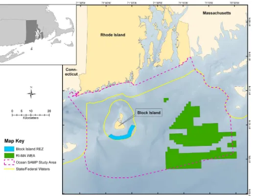
This paper analyzes the intensive process of applied research and sustained dialogue with multiple stakeholders that produced a marine spatial plan that defines regulatory policies and a site suitability assessment process for future forms of human activity and development. The plan encompasses a 3800 km2region that includes portions of the state's three-mile territorial sea and a larger area under federal jurisdiction in Rhode Island and Block Island Sounds (Fig. 1).
The preparation of this Ocean Special Area Management Plan (Ocean SAMP) was triggered by an initiative led by the then governor of Rhode Island designed to attract proposals for the construction of wind farms off the Rhode Island coast that would produce both a source of a renewable energy and a new industry anticipated to generate high paying jobs in a state with particu-larly high unemployment and low economic growth. The Ocean SAMP is designed to reduce the uncertainties of the often contentious environmental impact assessment process by placing
the assessment of proposals for new activities at specified sites within the context of a larger scale spatial plan. The plan examines trends in environmental conditions and in the distribution and impacts of existing human activities, and incorporates a spatial analysis methodology for identifying the areas that are potentially suitable for a new activity or structure. The Ocean SAMP builds upon Rhode Island's 30-year tradition of special area management planning for geographically defined areas where conflicts among competing human activities and threats to environmental qualities demand special attention. This approach is consistent with the scope and process set forth by the National Ocean Policy adopted by the Obama Administration in 2010.
The formulation and adoption of SAMPs has been a feature of the Rhode Island coastal management program since 1983. The six, smaller spatial scale SAMPs previously incorporated into Rhode Island's federally approved coastal zone management program required four or five years to proceed through the research, planning and adoption process. The Ocean SAMP, how-ever, was assembled on a two and a half year accelerated schedule. The research and planning phase got underway in mid-2008 and was adopted by the state's Coastal Resources Management Council (hereafter Coastal Council), the lead Rhode Island governmental agency for coastal management, in October 2010. In May of 2011, the Ocean SAMP was approved by the federal Office of Coastal and Contents lists available atScienceDirect
journal homepage:www.elsevier.com/locate/marpol
Marine Policy
0308-597X/$ - see front matter&2013 Elsevier Ltd. All rights reserved.
http://dx.doi.org/10.1016/j.marpol.2013.11.003 n
Corresponding author. Tel.:þ1 401 783 5379.
E-mail addresses:[email protected] (S.B. Olsen),
[email protected] (J.H. McCann),[email protected] (G. Fugate).
Ocean Resources Management (OCRM) in the National Oceanic and Atmospheric Administration (NOAA) as an element of the state's existing coastal management program. Following federal approval of the Ocean SAMP, a private firm, Deepwater Wind, initiated the permit application process for a pilot scaled wind farm offive turbines in state waters within the“Renewable Energy Zone” off of Block Island (BI REZ; seeFig. 1). Subsequently, the Bureau of Ocean Energy Management (BOEM), the federal agency that oversees activities related to oil, gas and renewable energy in the nation's outer continental shelf, began the process of desig-nating a Wind Energy Area (WEA) within the Area of Mutual Interest (AMI) identified by the Ocean SAMP as a potentially suitable area for a wind farm in federal waters. Applications for leases and permits for a full scale wind farm anticipated to contain approximately 200 turbines in federal waters is expected to follow if the pilot installation in the BI REZ moves forward successfully.
This paper examines the Ocean SAMP from the perspective of a governance baseline as suggested by the Land Ocean Interactions in the Coastal Zone (LOICZ) program, a member of the International Geosphere Biosphere Program baseline[1–3]. This calls for placing a new coastal or marine governance initiative within the context of the existing governance system. Part one of this paper therefore examines the evolution of coastal management in Rhode Island in which the
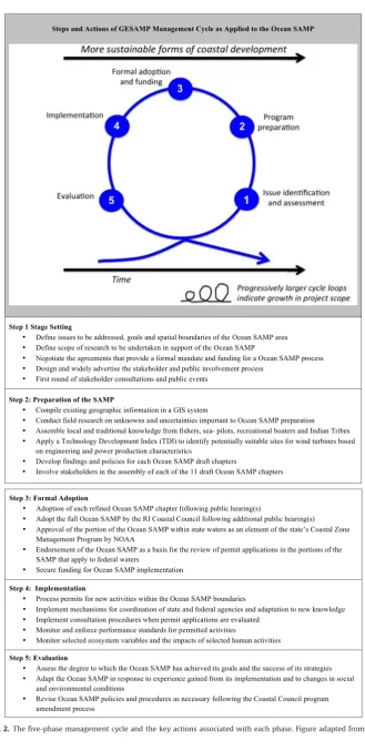
Ocean SAMP is the most recent chapter. Part two traces the process by which the Ocean SAMP was assembled by applying the five-phase policy cycle (Fig. 2)[4,5]that has structured all Rhode Island coastal management initiatives since the 1970s. The paper concludes with reflections on the dynamics of applying the ecosystem approach to planning and decision-making in the U.S. governance system in which state and federal levels of government share authority over new activities in marine waters.
The Ocean SAMP has been designed as an expression of the ecosystem approach. This calls for analysis, planning and decision making that considers the entire ecosystem, including humans, and evaluates the cumulative impacts of diverse human activities in order to regulate human activities in a manner that maintains or restores an ecosystem to a healthy, productive and resilient condition that provides the services that humans want and need [6]. Ecosystems are places, and maritime spatial planning is the process by which ecosystem-based management is organized to produce desired out-comes in marine environments [7,8]. In this paper governance is defined[9–11]as the formal and informal arrangements, institutions, and mores that structure and influence:
How resources or an ecosystem are utilized;and services within an ecosystem are distributed and used.
2. The context for coastal and marine management in Rhode Island
The state of Rhode Island adopted powerful coastal zone management (CZM) legislation in 1971, a year before the federal Coastal Zone Management Act was adopted. The Rhode Island Coastal Resources Management Act created a 17 member Coastal Council and granted it broad powers to both plan for and regulate activities that alter the state's 413-mile coastline and its three-mile territorial sea. The Coastal Council also has jurisdiction over specified activities anywhere in the state if they are shown to have an impact on the environment of the coastal region. The legislation provides the Coastal Council with authority to coordi-nate among agencies of government, serve as thefinal decision-maker in cases requiring multiple state and federal permits, and authority to serve as a binding arbiter in cases of conflict. The Coastal Council is charged with the task for the State of Rhode Island:
…to preserve, protect, develop and where possible restore
coastal resources for this and succeeding generations; through comprehensive long-range planning and management designed to produce the maximum benefit for society; and that preservation and restoration of ecological systems shall be the primary guiding principle by which alteration of coastal resources will be measured, judged and regulated.
Rhode Island's CZM program has evolved through two distinct generations of planning that have progressed through the five steps of the policy cycle (Fig. 2), and may be considered to be in its third generation since the implementation of the Ocean SAMP has doubled the geographic reach of the program's permitting program. Thefirst generation won federal approval in 1978 as a permitting program that relied upon a case-by-case impact assess-ment of applications for permits for the many activities under the program's jurisdiction. This approach proved to be inefficient, requiring many months to process routine permit applications and produced what the press and the public viewed as incon-sistent decisions in instances where the Coastal Council concluded that an alteration that was found to be suitable in one part of the state was judged to be unsuitable in another setting. The Coastal Council's decision-making criteria were seen as opaque and there were accusations of political interference in controversial deci-sions. These problems subjected the Coastal Council to strong criticism at public meetings and in the press. This prompted a redesign of the statewide regulatory program that required returning to the initial step of issue analysis and featured a complete overhaul of the Coastal Council's procedures, policies and permit granting criteria. The federal review process was repeated and the revised program became operational in 1983. This second generation program (1983–2011) features a zoning system for marine waters within the state's three-mile territorial sea with six “Water Use Categories.” Each water use category specifies permitted and prohibited activities and sets detailed standards that specify the types of alterations that can be made on the shoreline adjoining each Water Use Categories. Seventy percent of the state's waters are classified as Type 1, where no alterations are permitted, and Type 2, where only very limited construction and shoreline alterations may be permitted. Detailed performance standards are specified for all forms of coastal alterations and activities under the Coastal Council's jurisdiction.
This marine zoning component of the Rhode Island 1983 CZM program provided a foundation of experience and public accep-tance of marine zoning to into adjoining offshore waters under federal jurisdiction.
Rhode Island'sfirst SAMPs were developed in parallel with the redesigned statewide coastal permitting process. The SAMPs are the CZM program's response to those coastal areas where envir-onmental issues and competing human activities create complex situations that demand a comprehensive ecosystem analysis and a planning and policy making process for a spatial area that often extends beyond areas and activities subject to the Coastal Council's direct regulatory authority. The Coastal Council adopted thefirst SAMP in 1983. In the subsequent 30 yearsfive more SAMPs have been developed, formally adopted by the Coastal Council, and incorporated into the federally approved state CZM program. All SAMPs have featured research on the key management issues and sustained engagement with all interested stakeholders. The result is a detailed, spatially specific, plan of action and associated regulations that specify the roles and actions to be taken by the relevant municipal, state and federal government.
3. The challenges posed by the siting of wind farms in Rhode Island's offshore waters
Could an alternate to this well-established decision-making be put forward? The state's Coastal Resources Management Program pointed out that its SAMP process has demonstrated repeatedly that a carefully sequenced process that integrates interdisciplinary research, public education and consultation with issue-focused planning has successfully resolved conflicts and produced policies and a plan of action in a geographically defined area of concern to a variety of stakeholders. The coastal program suggested that an application of the SAMP process to identify potentially suitable sites for wind turbines in the context of a comprehensive spatial analysis of existing human activities and environmental sensitiv-ities would create the conditions for a less devise and lengthy permitting process. The suggestion was accepted by the Governor on the condition that an Ocean SAMP would be completed and formally adopted by the Coastal Council within two years. The scope of the effort was defined in a Memorandum of Under-standing (MOU) among the state's Renewable Energy Fund, with the Coastal Council, whose director served as the program man-ager, and the University of Rhode Island. Initial funding of $3.2 million was provided by the Rhode Island Renewable Energy Fund that is drawn from a tax levied on electrical user fees. This was subsequently expanded with other state and federal funds as well as in-kind contributions of the University of Rhode Island that together provided for a total budget of $7.6 million. The majority of the funds were allocated for data generation, integration and analytic process that feature a sophisticated geographical informa-tion system (GIS) andfield research undertaken by an interdisci-plinary team drawn from various departments of the University. The University of Rhode Island's Coastal Resources Center (CRC) assumed its usual responsibility for designing and managing the public education and stakeholder consultation process and draft-ing the Ocean SAMP.
4. The federal role in coastal and marine management
At the federal level, the delays and conflicts generated by the impact assessment process were also being recognized and a complex sequence of initiatives and reforms occurred in parallel with the Ocean SAMP design process. In the United States, indivi-dual coastal state's exercise authority over a territorial sea usually defined as extending 3 miles seaward of their shoreline. In marine and coastal areas under their jurisdiction, policy making, planning and decision-making is primarily the prerogative and responsibility of each state. Federal authorities take precedence over such topics as defense, navigation and interstate commerce in state waters and have the lead role in planning and decision making in federal waters overlying the outer continental shelf and exclusive economic zone (EEZ). The limitations of federal authority over areas and resources under state control have led the federal government to rely upon a combination of incentives and dis-incentives to encourage coop-eration between the federal government and counterpart state agencies and programs. One example is the Federal Coastal Zone Management Act that was enacted in 1972, a year after Rhode Island's coastal management legislation, and is administered by the federal office of Ocean and Coastal Resources Management (OCRM) in the Department of Commerce.
As a voluntary program, the federal Coastal Zone Management Act offers states two incentives to participate in the program. The first is federal funding, initially to formulate a state coastal zone management (CZM) program and, if the result is found to conform with federal standards and approved by OCRM, annual grants to support the implementation of each state's program over the long term. The second incentive is the“federal consistency clause.”This requires that "each federal agency conducting or supporting activities directly affecting the coastal zone shall conduct or
support those activities in a manner which is, to the maximum extent practicable, consistent with approved state management programs" (Coastal Zone Management Act, Section 307(c)(1), 1972). The consistency clause may be applied not only to federal actions within the state's coastal zone but also to federally licensed or permitted activities in the adjoining Outer Continental Shelf and EEZ that can be demonstrated to directly affect resources and activities within a state's coastal zone. The consistency provision is designed to encourage a state CZM program and the lead federal agency to work together when assessing the impacts and making permitting decisions on proposals for activities subject to the environmental impact assessment process in federal waters adja-cent to a state's territorial sea. These consistency provisions lie at the heart of the Ocean SAMP strategy and design.
The federal CZM Act was a response to the findings and recommendations of the hallmark report “Our Nation and the Sea”published in 1969 by the Stratton Commission. Three decades later the Oceans Act of 2000 called for another commission to make recommendations for a comprehensive and coordinated national ocean policy. The Commission's report released in 2004 documented the declining conditions of the nation's oceans and coasts and called for a new governance framework based upon the principles of ecosystem-based management. Complementary recommendations were made by the Pew Oceans Commission a year earlier, a private effort conducted in parallel with the Oceans Commission that issued its report in 2004. Both reports found that the degradation of coastal resources and the fragmentation of responsibility and of programs designed to address coastal and marine issues remain major national challenges. Both argued for integrated multi-use ocean planning.
In 2009, a year after the Ocean SAMP got underway, President Obama established an Interagency Ocean Policy Task Force that identified nine national priority objectives. One of these calls for the implementation of ecosystem-based coastal and marine spa-tial planning and management "designed to decrease user conflict, improve planning and regulatory efficiencies, decrease associated costs and delays, engage affected communities and stakeholders, and preserve critical ecosystem functions and services”[12].
In 2010, President Obama adopted thefinal recommendation of the Task Force by promulgating, as an Executive Order, a National Ocean Policy. This establishes a framework for coastal and marine spatial planning (CMSP) as an expression of integrating ecosystem-based management. Issued in the same year that the full Ocean SAMP was adopted by the RI Coastal Council, the CMSP calls for analyzing current and anticipated ocean uses, and identifying areas most suitable for various activities–precisely what the Ocean SAMP had accomplished.
5. The assembly of The Ocean Special Area Management Plan
and stakeholder involvement change in each phase. While the definition of the key actions associated with each phase may need to be adjusted for a given application, the version presented inFig. 2 captures the essential features of the phases and is used here as the organizing framework for examining the process by which the Ocean SAMP is assembled.
5.1. Phase 1: Stage setting
For the Ocean SAMP the most crucial actions associated with Phase1 of the GESAMP cycle were present when the initiative got under way in 2008. The authority and mandate for managing marine activities from an ecosystem perspective has been vested in the Coastal Council since 1971 and the well-established rela-tionship between the Coastal Council and the CRC had repeatedly demonstrated the capacity of the Rhode Island program to gen-erate policies and a spatial plan of action in areas of conflict. Good working relationships had matured over the years between the Rhode Island coastal program and federal agencies with important coastal and marine responsibilities. The remaining critical Step 1 tasks were therefore to define the issues that the Ocean SAMP would address, negotiate the appropriate spatial scale, identify the necessary research, design how a multidimensional stakeholder consultation process would proceed, and secure adequate funding.
5.1.1. An issue-centered approach
At the heart of the SAMP approach is the selection of the issues (both problems and opportunities) that a spatially defined SAMP process will attempt to resolve or mitigate. The issues determine the scope of the information gathering and research process and the delineation of the boundaries of the spatial area that will be the subject of the planning and policy development process. These crucial decisions are in turn the basis for identifying the stake-holders in government, civil society and the business community that need to be involved in the process. The primary issue that the Ocean SAMP was designed to address is the conflicts, expense, delays and uncertain outcomes that are typically associated with the federal environmental impact assessment (EIA) process. The central objective was therefore to design and incorporate into the state's coastal management program a complementary planning and decision-making process that would place the federal EIA process within a more inclusive, efficient and transparent decision making framework for evaluating proposals for new activities, including a wind farm in Rhode Island's offshore. The Ocean SAMP was designed to identify and map the spatial distribution of the environmental trends, cultural features, and current human activ-ities, as well as place current conditions in the context of long term trends and projections of future pressures–including those related to climate change. It would then identify spatial areas judged to be potentially suitable and unsuitable for a wind farm, while simul-taneously protecting existing uses and the flows of ecosystem goods and services with the planning region. The second issue was the need for a process of analysis and planning that would engage the many stakeholders in a sustained and informed dialogue that would build trust in the process itself and support for the conclusions reached regarding site suitability for wind turbines development. The third issue was the need to generate and make available to all parties the information required by the federal EIA process and would be the basis for evaluating and permitting the anticipated permit applications. By gathering data on resources and uses for the entire Ocean SAMP region, the analysis provided by a site specific EIA would be nested within a larger analytical framework and a place the site selected by a developer in a broader context of spatial analysis and planning.
5.1.2. Initial SAMP goals
In light of these three major issues the goals of the Ocean SAMP as set forth in the 2008 MOU were defined as the formulation of a framework for coordinated decision-making between state and federal management agencies that would:
Streamline the permitting process; Promote and enhance existing uses; Encourage marine-based appropriate economic development; and Restore and maintain the ecological integrity and resilience ofthe biophysical and socio-economic systems in the Ocean SAMP region.
These goals were complemented by a set of principles that call for basing decisions on the best available science, involving all stakeholders in an inclusive and transparent process and devel-oping a long-term monitoring and evaluation system as the basis for adaptive management.
5.1.3. Definition of the boundaries of the area of focus
Since the Ocean SAMP was undertaken in anticipation of proposals to construct wind turbines off the Rhode Island coast, the definition of the spatial dimensions of the area of focus needed to include all areas that might be considered suitable for such structures. From an engineering perspective, the furthest extent for the cables by which the alternating current energy produced by a wind farm would be connected to the on-land electrical grid remain cost effective is 20 miles from the coast. Initial studies suggested that sites within Narragansett Bay might be suitable for wind turbines but it was subsequently concluded that winds within the Bay are inadequate. Along the ocean shore it was seen as important not to alter the water use categories adopted in 1983 that regulate the intensity of development along the shoreline. The Ocean SAMP region was therefore defined to begin 500 ft seaward of the ocean shoreline and extend out to the 65 m depth contour. For pragmatic reasons, the eastern and western boundaries were defined as those established through existing agreements with the neighboring states of Massachusetts and Connecticut. This is the area considered by the U.S. Army Corps of Engineers when evaluating alternatives for the offshore dredge material disposal site and made the extensive information gathered for that effort directly transferable to the Ocean SAMP planning process. So defined, the Ocean SAMP region (Fig. 1) encompasses a marine area of 3800 km2(1467 square miles).
It was initially assumed that wind turbines would be con-structed on monopoles similar in design to those in Europe's offshore. However, Deepwater Inc, the anticipated developer of a wind farm off Rhode Island, announced that it would place turbines on the jacketed platforms used by the petroleum industry in offshore waters. As a consequence water depths within the sounds would not be a limiting factor and the analysis of potential sites had to include the Ocean SAMP region in its entirety.
5.1.4. Investments in research
absent or rudimentary when the Ocean SAMP got underway. Gathering and analyzing such data became a major feature of the research effort since endangered species are present that command special attention in an EIA process and, where present, have the potential to eliminate consideration of a proposed new human activity or structure.
The seabed and sub-bottom of the Ocean SAMP region are heterogeneous, the product of submergence of a glaciated landscape containing recessional moraines, outwash plains and valleys and occasional deep "holes". Since wind turbines have to be secured to the seafloor and the costs of construction vary greatly with bottom type, another focus of the Ocean SAMP research was to gather information on sub-surface geology in the areas that appeared to be potential candidate sites for wind farm construction. It was considered important, for example, to identify submerged glacial moraines and areas of glacial till that are likely to contain large boulders that would complicate the process of stabilizing the pilings of a platform and could significantly increase construction costs. The moraine areas were also found to be rich habitats and therefore both prime fishing grounds and areas of potential archeological interest as ancient settlements when sea level was lower.
5.1.5. The stakeholder consultation strategy
A crucial feature of Phase 1 is the design of a consultation process designed to create an informed and supportive constitu-ency for both the process by which a SAMP is assembled and the content of the resulting policies and plan of action. As soon as the process got underway in mid-2008, press releases described the objectives and scope of the Ocean SAMP and a user-friendly website was launched. A public education and involvement process featured seminars and public workshops designed to respond to the issues identified by the interested public as well as specific stakeholder groups. The consultative groups established at the beginning of the initiative included the following:
A 12 member Science Advisory Committee provided a forumfor discussion of the design of the research and the interpreta-tion of the researchfindings
A State Technical Advisory Committee that brought together allthe state agencies with interests in the Ocean SAMP region.
A Federal Technical Advisory Committee periodically broughttogether representatives of all federal agencies that will play a role in permitting new activities proposed in the Ocean SAMP region.
An inclusive Stakeholder Group, accessed through a websiteand list serve, held monthly meetings at which research findings were presented, their implications discussed and the scope and contents of the Ocean SAMP chapters reviewed. When major issues surfaced meetings with individual parties and groups were arranged. This consultative process featured particular attention to the federally recognized Narragansett Tribe hat has a special interest in the esthetic values of the region and areas of potential ancient settlement.
Technical Advisory Committees were established for each ofthe 11 chapters of the Ocean SAMP. These were composed of scientists, government agency representatives and resource users selected for their knowledge of the topics addressed by a given chapter. These committees advised and commented on the scope and content of each chapter.
Before the research, consultation and planning process got underway in 2008, the web site featured a calendar that specified the date at which each of the 11 chapters of the Ocean SAMP would be released for comment and the date by which each chapter and then the entire document would be adopted by the Coastal Council. Major public workshops and seminars that
featured experts on various aspects of the Ocean SAMP region and on the impacts of offshore wind farms were also listed. The calendar was displayed at every meeting and was prominent on the website. This gave all interested parties a common under-standing of how the Ocean SAMP would be formulated and reinforced the message that the process would be transparent and inclusive. Indeed the targets set by the calendar were met with only minor adjustments. All comments were posted and responded to on the web site for everyone to see.
5.2. Phase 2: Preparation of the Ocean SAMP
With the fundamental building blocks of Phase 1 in place, Phase 2 was devoted to developing the substance of the SAMP. This required conducting numerous research and data integration activities while maintaining a sustained and informed dialogue within the interdisciplinary team. The results of the information gathering and analysis process were conveyed to the many stakeholders as they emerged. Equally important was the need to engage with the governmental authorities so that options for policies and procedures were discussed and these crucial stake-holders were well informed when the plan entered the formal approval process.
5.2.1. Integrating Traditional Knowledge
A review of recent EIS documents for offshore permit applications identified the types of information that have emerged as most critical to this process and underscored the importance of the analysis of alternative sites for a proposed activity. The spatial analysis process began with the verification and transfer of existing spatial information on the Ocean SAMP region into a geographic information system (GIS). When presented at initial public workshops, this proved to be an engaging exercise that revealed that some of the information on navigation charts was erroneous (including nonexistent cableways) and identified important information gaps. Overlays showing the contours of average wind velocities and data on depth to bedrock and glacial moraines showed that some of the areas previously identified as suitable for wind turbines had major constraints from a construction perspective. The detail of this initial analysis and the complexity of the patterns of use and physical features of the Ocean SAMP region encouraged those with detailed traditional knowledge– such as commercial and sport fishers, sea pilots and organizers of yachting regattas–to work with members of the Ocean SAMP team to prepare detailed maps of the distribution of these activities. The GIS system encouraged overlaying and integrating scientific and tradi-tional knowledge in an engaging, visually accessible manner.
An important product of this initial analysis was the identifi ca-tion of potentially suitable areas where the limited resources for detailed field work were subsequently concentrated. This was critically important since the size of the Ocean SAMP region and the time andfinancial constraints for producing the plan made it necessary to focus elements of the field work on the areas of believed to be the likely candidates for a wind farm and for which detailed information would be required when preparing an EIS. This initial mapping provided a context for the compilation of technical information from multiple sources by teams of scientists at the university and an extensive program offield observations. This research was framed around two sets of issues that became the focal points for the spatial analysis.
Environmental and engineering issues
What is the distribution and abundance of coastal and offseveral bird species known to be present are classified as endangered.
What is the distribution and abundance of marine mammals including several species of endangered and threatened whales? What are the baseline seasonal distribution patterns andspecies composition of plankton?
What are the geological features of the seafloor that arerelevant to the construction of wind turbines?
What are the potential impacts of climate change on theecology of the Ocean SAMP region and the human activities it supports?
From an engineering perspective, what were the sitingrequire-ments that are critical to the placement and operation of turbine platforms?
What are the areas with the best potential to producerenew-able energy at the utility scale?
Societal issues
What is the distribution of commercial and recreationalfishinggrounds?
What is the distribution of recreational boating (sailingregat-tas, sport-fishing) and associated recreational businesses (whale watching, shark diving, charter boats)?
Where are the archeological sites of concern to theNarragan-sett Indian Tribe and significant shipwrecks?
What are the potential impacts of the construction, operationand decommissioning of wind turbines on existing human activities and associated living resources?
What are the potential impacts of offshore wind energy on jobsand electricity rates in Rhode Island?
5.2.2. The Technology Development Index
As the layers of spatial information accumulated a second tier of analysis was undertaken that considered the engineering and economic attributes of the wind turbines using a Technology Development Index (TDI) to identify areas that present major engineering and economic constraints[19]. This analytical method was used to identify potentially suitable sites for a wind farm and could be applied to analyze the siting issues raised by any other proposed activity or structures including, for example, an offshore aquaculture operation or the placement of a submarine cable.
For wind turbine construction, the TDI is defined as the ratio between the technical challenge of construction and the power production potential. The potentially suitable areas were gridded and an analysis was performed for each grid. The grids with the lowest TDI were classified as the most suitable sites for the proposed facility. Since this form of analysis requires calculating numerical estimates for each variable, and the uncertainties for some variables are relatively high, simulations could be performed deterministically using a Monte Carlo method to understand the impacts of such uncertainties on the conclusions reached. In the case of wind turbines, this required identifying the areas where the winds are insufficient and where there are major constraints to their construction. Such analysis identified the potential sites for a wind farm that are not constrained by significant human activities or natural resources, contain sufficient wind, are relatively close to a connection to the electrical grid and do not appear to contain significant construction constraints –such as boulderfields and shallow depth to bedrock. As this second tier information has become available the maps of potentially suitable areas in both state and federal waters were refined, shared with the various stakeholder groups and discussed at public meetings.
The TDI method has many similarities with the Marine Resource Assessment System (MarS) used by the UK Crown Estates (http://www.thecrownestate.co.uk/mars) that also employs a multi-step process based on GIS maps of the energy resource and the siting constraints on the proposed facility. The MarS analysis, like the TDI, identifies areas with use conflicts and areas with development potential. In both cases, this is followed by a sustainability andfinancial analysis that apply weighting factors to the different variables. However, the MarS methods are proprie-tary and are not available for review or evaluation. In the TDI system, in contrast, each step in the process is traceable and open to examination by any interested party.
5.2.3. Implementation policies, standards and decision-making procedures
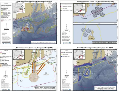
Chapter 11 of the Ocean SAMP sets forth the policies, proce-dures and regulations by which the SAMP will be implemented. The general policies address responses to the ecology of the Ocean SAMP region, climate change and the major categories of human activity including offshore renewable energy and other forms of offshore development. Regulatory standards detail policies and performance standards for Areas of Particular Concern (APCs) and for Areas Designated for Preservation (ADPs) and include stan-dards for pre-construction and construction (Fig. 3). Areas Desig-nated for Preservation include all waters within the 20 m depth contour. This belt of shallow waters has been found to be of exceptional value to sea ducks. All forms of large-scale offshore development are prohibited in the ADP zone. The ADP zone lies almost entirely in state waters where the Coastal Council exercises direct authority. The area that was found most suitable for wind turbines within state waters was classified as a Renewable Energy Zone (refer toFig. 1).
To achieve the goal of “protecting and enhancing existing activities”, the Ocean SAMP identifies APCs, which include areas:
With unique or fragile physical features or important naturalhabitats
Of high natural productivity Of significant historical or cultural value Of substantial recreational value Important for navigation, transportation, military or otherhuman uses
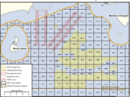
Of highfishing activityThe APCs encompass 53% of the Ocean SAMP region. The Ocean SAMP policies state that any application for a permit in these areas must demonstrate (1) that there are no practicable alternatives that are less damaging in areas outside the APC and (2) that the proposed project will not result in a significant alteration to the values and resources of that APC. The TDI analysis has identified the spatial areas in federal waters that are not within the APCs or the ADP that are considered to be potentially suitable for the placement of wind turbines. The analysis has identified an“Area of Mutual Interest”(AMI) along the offshore border between Rhode Island and Massachusetts that is considered by both states to be the most suitable site for a wind farm of the scale anticipated to be proposed by Deepwater Wind Inc.
5.2.4. Preparing for adaptive management
from both Rhode Island and Massachusetts will be requested to advise on the potential impacts of any proposed offshore activities on fisheries. A panel of scientists has been assembled as a Habitat Advisory Board to address the management implications of new insights into the condition and value of natural habitats in the Ocean SAMP region and the impacts of unfolding climate change. A Joint Agency Working Group of federal and state agencies will provide a forum for the review of applications for permits and the issues raised by the construction operation and decommissioning of any offshore development. A biennial public forum will feature discussion of reports on conditions in the Ocean SAMP region, and the ongoing assessments of any application for permits in the SAMP region. Another policy calls for a major review of the Ocean SAMP document everyfive years. Since the adoption of the Ocean SAMP by the Coastal Council in 2010, four amendments have been made to keep the SAMP congruent with changes in the federal leasing and permitting proce-dures. These reflect the adaptive nature of the document.
5.3. Phase 3: Formal adoption of the Ocean SAMP
Phase 3 is concerned with the formal adoption of the Ocean SAMP and is the bridge between planning and the implementation of a plan and its associated policies and regulations. While Phase 2 is concerned with the generation and interpretation of information and the
meaningful, often informal, engagement of stakeholders, Phase 3 is a formal policy making process that is shaped by the relationships among agencies of government with different interests and responsi-bilities at the different spatial scales of a nested governance system. The formal adoption step is critical for any party wishing to see alterations in the plan or, in some cases, to block its transition into law. In the case of Rhode Island, the structure of this formal adoption process is well known since the Coastal Council has long been the lead state agency for coastal planning and permitting and the standards for federal approval by the Office of Ocean and Coastal Resources Management are widely known and accepted.
Since each chapter engaged a somewhat different group of stake-holders, and since it was important to gauge reactions to the infor-mation and the policies developed for each topic, it was decided that the Ocean SAMP would be adopted by the Coastal Council chapter-by-chapter over a six month period. This required proceeding through the sequence of informal public workshops, formal public hearings, refinements and formal adoption by the Coastal Council for each chap-ter as set forth by the widely distributed Ocean SAMP calendar. When all the chapters had proceeded through this process some adjustments were made to the document as a whole. After three hearing on the refined version, the Ocean SAMP was approved by the Coastal Council on October 19, 2010, within the timeframe called for by the MOU negotiated at the beginning of the process two years before.
During Phase 2 the Ocean SAMP team worked closely with NOAA to assure that the policies and regulations were consistent with the mandate and authority of both the Council and the federal coastal and ocean management program. As a result, federal approval of the Ocean SAMP in May 2011 was processed as a routine program change. Three months later, through a process termed the Geographic Location Designation (GLD), NOAA identified all federal activities that will be subject to the consis-tency clause and thereby to review by the state. This means that the Ocean SAMP compilations of information and implementing policies will be a basis for all decision making by federal agencies of government and thereby sets the stage for collaborative plan-ning and decision making with the Rhode Island coastal manage-ment program.
In the same year that the Coastal Council formally adopted the Ocean SAMP, the federal agency, Bureau of Ocean Energy Manage-ment (BOEM), formerly Minerals ManageManage-ment Service (MMS), was established by the Secretary of Interior to oversee development of oil and gas, renewable energy and other mineral and energy resources on outer continental shelves under US jurisdiction. BOEM promulgated a new leasing and permitting process for renewable energy projects, the Smart From the Start Program that disaggregates the environmental impact assessment process into an incremental sequence of steps. This calls for BOEM to identify potential Wind Energy Areas, and to solicit information from states and interested parties on these areas as an Environmental Assessment is prepared. The next step is to publish leasing notices for tracts of potential interest to developers and schedule a lease sale. A developer who wins a lease through an auction process will then conduct surveys in their leasehold and prepare a Site Assessment Plan that is submitted to BOEM for review and approval. If, within five years, the leasee decides to proceed to
commercial development it must submit a Construction and Operational Plan to BOEM for review and approval. BOEM then prepares a fully detailed Environmental Impact Assessment and, if itfinds no significant impact, will approve the operational plan for a 25 year term in which to construct the facilities and generate electricity. After 25 years decommissioning is required or the lease may be renewed.
In 2012, in consultation with Rhode Island and Massachusetts, BOEM identified the “Wind Energy Area” (WEA) within the previously defined AMI identified by the Ocean SAMP as an area viable for wind energy development. The close working relation-ship with the variousfishing operations in this area and the Ocean SAMP team led to very detailed information being compiled that identified tracts that are particularly important to one to four fisheries (trawlers, seiners, lobster pots, sportfishing) in an area known as Coxes Ledge. The Rhode Island coastal program com-piled this information and BOEM agreed to remove the most heavily used blocks from consideration (Fig. 4). The auction for the remaining lease blocks that are of interest to wind farm developers was held on July 30th, 2013.
5.4. Phase 4: Ocean SAMP implementation
The critical issue is whether the process of assembling the Ocean SAMP and winning its approval at both the state and federal level will indeed simplify the process of sitting a new activity, such as a wind farm, in marine waters that generate a wealth of environmental goods and service and is already crowded with human activities. Will the existence of the Ocean SAMP prevent the years of delays and legal actions that have characterized the offshore permitting process in the past? CRC and its partners have
had to recognize from decades of experience in coastal and marine management in the US and several other nations that a well-designed and well-executed managementprocess, as suggested by the policy cycle, may not produce the desiredoutcomes. Especially critical is the transition from analysis, planning and policy making (Phases 1–3 of the cycle) to the effective implementation of a new governance initiative (Phase 4). The CRC's experience, not only in developing countries, but also in many instances in the U.S. and European Union, is that place-based analysis of complex socio-environmental issues, including often significant investments in research and the preparation of technically excellent plans, pro-posals and policy reforms, does not produce an efficient decision making that is accepted as reasonable and balance by stake-holders. This can be termed the“implementation gap”and it is frequently ascribed to an absence of sufficient“political will.”This has led the Coastal Resources Center to complementing the governance cycle with the Orders of Outcomes framework (Fig. 5)[2,5,11]. This framework disaggregates the ultimate goal of sustainable forms of development into a sequence of more immediate and tangible outcomes.
The 1st order addresses the enabling conditions that experi-ence in the practice of the ecosystem approach in a diversity of settings suggests as most critical to the successful implementation of a plan or program – in this case, the Ocean SAMP. These outcomes of a successful planning and policy making process have been defined as follows:
Unambiguous goals address both the societal andenvironmen-tal dimensions of the conditions that the Ocean SAMP is designed to achieve.
Well informed constituencies actively support the OceanSAMP's goals and the means by which they will be achieved;
The capacity is present within the institutions responsible forthe Ocean SAMP to successfully implement its procedures, policies and spatial plans; and,
Governmental commitment for the implementation of theOcean SAMP is expressed by the formal endorsement of the plan by the lead state and federal authorities; the authorities and thefinancial resources are in place to implement the Ocean SAMP over the long term.
The actions taken in Phases 1–3 of the Ocean SAMP were designed from their inception to generate these First Order preconditions. However, assessing the degree to which the Ocean SAMP and parallel revisions to the federal leasing and permitting process have created a better context for decision-making on proposals for renewable energy offshore facilities will be known only after the responsible state and federal agencies have acted upon proposals for wind farms within the Ocean SAMP region. It will then be apparent whether the application of the SAMP approach to a marine region spanning both state and federal jurisdictions has indeed produced a more efficient and less contentious decision-making process. As of 2013, the evidence is that the permitting process for the pilot scaled wind farm off Block Island is proceeding as expected. So far, major objections to the lease blocks selected for sale by BOEM in the Wind Energy Area. Resistance to an offshore wind farm has thus far been focused on the high cost of the energy that would be produced.
6. Discussion
The expansion in the geographic reach of the Rhode Island coastal management program brought by federal approval of the Ocean SAMP as an element of the state's Coastal Management Program may be considered as the beginning of a third generation of the Rhode Island coastal program. The geographic scope of the program's planning and permitting has doubled since the Ocean SAMP region is similar to the size to the land area of the state. It is notable that the Ocean SAMP has recapitulated several features of the transition from thefirst generation of the program to the second. The difficulties encountered by thefirst generation of the program was that basing permit decisions on case-by-case impact assessments let to incon-sistencies, conflicts, prolonged delays and an erosion of public support for the program. The response was to adopt a comprehen-sive spatial planning approach–first for the state's coastal region as a whole through the 1983 water use zoning and the associated performance standards for each potentially permitable activity–and then for spatially defined areas of particular concern through the preparation of SAMPs. The boundaries of thefirst six SAMPs have in
several cases extend into areas where the Rhode Island Coastal Program does not have direct permitting authority but can apply its legislative mandate to address “ecological systems” and play a coordinating function. In essence, the Ocean SAMP has repeated this process in a marine region the bulk of which is not under the direct jurisdiction of the state of Rhode Island.
Another major conclusion is that the initiative of an individual coastal state to extend its coastal and marine planning and management functions into adjoining federal waters may be a more effective way to negotiate where new offshore activities may be accommodated than the regional task forces called for by the National Ocean Policy and administered by BOEM. Such task forces have been established for the Atlantic, Pacific and Alaska to bring together affected states, local and tribal governments and federal agencies to discuss renewable energy options, exchange data and provide for a forum to discuss leasing and permitting options. They are designed to only serve a coordinating function and have an uncertain funding base[20]. State-based marine spatial plan-ning that extends into federal waters, as illustrated by the Ocean SAMP, may offer a stronger model for proactive ocean planning. This is because the Coastal Zone Management Act bridges the regulatory divide between state and federal waters by granting states the authority to review projects in federal waters for consistency with state coastal management plans that have been previously approved by the federal government. While the federal government retains thefinal word on federal permits, the federal consistency provisions can place such decisions within an explicit context of detailed spatial planning and policy making. Where states take the initiative to engage in an MSP planning process that involves all stakeholders and is constructed upon consideration of local conditions, local preferences and locally generated scientific knowledge provides an attractive alternative to a more centralized approach. The federal Coastal Zone Management Act provides states and federal agencies with a place to negotiate inter-jurisdictional issues and together develop marine spatial planning arrangements that have immediate legal force.
The attention given to understanding the context within a governance initiative is made as suggested by LOICZ governance baselines demonstrates that Rhode Island offers an unusually promising setting for an initial venture into MSP. An unusual feature of the Rhode Island context, as suggested by part one of this paper, is the relationship between the Coastal Council and the CRC at the University of Rhode Island. Over four decades these two organizations have developed a distinctive approach to coastal and marine planning and management that enjoys considerable trust and support among stakeholders in the private sector and govern-mental agencies.
The partnership between the CRC and the Coastal Council has been the central mechanism by which the SAMPs have been formulated. For such undertakings, the CRC assembles, at the Council's request, an interdisciplinary team that may include social and natural scientists and engineers drawn principally from the university. These work together as an interdisciplinary team to define and conduct the research that provides the foundation of relevant science for policies and plans to be developed through a sustained public consultation process and submitted to the Coastal Council for its consideration and adoption. The typically modest funding provided by the state's Coastal Management Program for the development of each SAMP has been complemented by competitive grants for research and extension services awarded by the Rhode Island Sea Grant College Program and, in many cases, grants and contracts awarded by various governmental programs and private foundations. When developing a SAMP, members of the CRC work with the Coastal Council to design and implement the workshops and other events at which the issues addressed by a SAMP are discussed. Potential Coastal Council policies and
courses of action are formulated in consultation with stakeholder groups and discussed at public workshops in the presence of Council members. Once afinal draft of a plan or policy has been assembled the Coastal Council enters the formal review and adoption process with its requisite hearings, the formal submis-sion and response to testimony, modification of the plan and formal adoption by vote of the Coastal Council members. Each SAMP is then reviewed by NOAA Office of Ocean and Coastal Resource Management and, if necessary after further refinement, incorporated as an element of the federally approved Rhode Island coastal program.
There are several advantages to this arrangement. In the case of the Ocean SAMP, for example, scientists that would otherwise be retained by the wind farm developer become members of the team assembled by the CRC. They agreed that they would not also contract with the developer and thereby risk a conflict of interest. All the information generated in support of a SAMP is in the public domain rather than proprietary as would be the case if produced under contract to a developer. The CRC operates as a university-based third party that coordinates workshops and educational events, presents the information gathered, and facilitates discus-sions of the implications of research findings to the emerging policies of the SAMP. The CRC and university researchers enjoy high credibility with the public and this creates a degree of separation between the processes of information gathering and analysis and the policy selection and eventual permit decisions that are the prerogative of the Coastal Council.
In conclusion, the Ocean SAMP offers other states with a potentially powerful model for marine spatial planning that capitalizes on the consistency clause of the federal Coastal Zone Management Act. It suggests that this expression of the ecosystem approach to planning and decision making need not be so all encompassing, complex and time consuming as to be practically untenable. To the contrary, the Ocean SAMP may prove to make offshore permitting a transparent and efficient decision-making process that benefits both existing activities and developers while promoting an ecosystem stewardship ethic.
Acknowledgments
The authors would like to thank the Rhode Island Sea Grant College Program for their long-term commitment to addressing coastal issues, including ecosystem and human health, resource protection and sustainability, responsible development of areas, and establishing sustainable coastal communities.
References
[1] Land–ocean interactions in the coastal zone, part of the International Geo-sphere–Biosphere Programme (IGBP) and the International Human Dimen-sions Programme on Global Environmental Change (IHDP). Available online at
〈http://www.loicz.org/〉[Last accessed: March 29, 2013].
[2] Olsen SB, Page GG, Ochoa E. The analysis of governance responses to ecosystem change: a handbook for assembling a baseline. Land–Ocean Interactions in the Coastal Zone (LOICZ) reports and studies #34. Germany: GKSS Research Center; 2009.
[3]Olsen SB, Olsen E, Schaefer N. Governance baselines as a basis for adaptive marine spatial planning. J Coast Conserv 2011;15:313–22.
[4] GESAMP. The contributions of science to integrated coastal management. GESAMP reports and studies No. 61, Rome, Italy; 1996.
[5]Olsen SB. Frameworks and indicators for assessing progress in integrated coastal management initiatives. Ocean Coast Manag 2003;46:347–61. [6] McLeod KL, Lubchenco J, Palumbi SR, Rosenberg AA. Scientific consensus
statement on marine ecosystem-based management (signed by academic scientists and policy experts with relevant expertise). Communication Partner-ship for Science and the Sea; 2005. Available online at〈http://www.compas sonline.org/sites/all/files/document_files/EBM_Consensus_Statement_v12.pdf〉
[Last accessed: April 2, 2013].
[8]Ehler C, Douvere F. Marine spatial planning: a step-by-step approach towards ecosystem-based management. Paris: International Oceanographic Commis-sion, UNESCO; 2009.
[9]Juda L. Considerations in developing a functional approach to the governance of large marine ecosystems. Ocean Dev. Int. Law 1999;30:89–125.
[10]Juda L, Hennessey T. Governance profiles and the management and use of large marine ecosystems. Ocean Dev Int Law 2001;32:43–69.
[11]Olsen SB, Sutinen JG, Juda L, Hennessey TM, Grigalunas TA. A handbook on governance and socioeconomics of large marine ecosystems. Narragansett, Rhode Island: Coastal Resources Center, University of Rhode Island; 2006. [12] The White House Council on environmental quality. Final Recommendations
of the Interagency Ocean Policy Task Force, 19 July 2010. Publication Title: Federal Register Volume 75, Issue 148 (August 3, 2010); 75 FR 45606. Available online at〈http://www.whitehouse.gov/files/documents/OPTF_FinalRecs.pdf〉
[Last accessed April 1, 2013].
[13]Cicin-Sain B, Knecht RW. Integrated coastal and ocean management: concepts and practices. Washington DC: Island Press; 1998; 519.
[14]Davis R, Hirji R, editors. Water resources and environment technical note C.2. Washington DC: The World Bank; 2003.
[15]Davis R, Hirji R, editors. Water resources and environment technical note D.1. Washington DC: The World Bank; 2003.
[16]Richter BD, Mathews R, Harrison DL, Wigington R. Ecologically sustainable water management: managing riverflows for ecological integrity. Ecol Appl 2003;13(1):06–224.
[17] Jønch-Clausen, T. Integrated Water Resources Management (IWRM) and water efficiency plans by 2005. Why, what and how? TEC background papers No. 10. Sweden: Global Water Partnership Technical Committee; 2004.
[18] Olsen SB, Ipsen N, Adrianse M. Ecosystem-based management: Markers for assessing progress. The global program of action on land-based sources of pollution, Amsterdam, The Netherlands; 2006.
[19]Spaulding ML, Grilli A, Damon C, Fugate G. Application of Technology Development Index and principal component analysis and cluster methods to ocean renewable energy facility sitting. J Mar Technol 2010;4(1):8–23 ([Special Edition on Offshore Wind]).
[20]Burger M. Consistency conflicts and Federalism choice: marine spatial plan-ning beyond the states' territorial seas. Environ Law Report, 4; 2011; 10602–10614.
[21] Rhode Island Coastal Resources Management Council. Rhode island ocean special area management plan. Adopted October, 2010. Available online at
〈http://www.crmc.ri.gov/samp_ocean.html〉[Last accessed: March 30, 2013]. [22] Bureau of ocean energy management. State activities: Rhode Island. Available
![Fig. 5. The orders of outcome framework considering spatial and temporal scales. Figure adapted from [5].](https://thumb-ap.123doks.com/thumbv2/123dok/1734272.1115153/11.595.138.447.66.302/orders-outcome-framework-considering-spatial-temporal-figure-adapted.webp)
