IJG Vol. 44, No.2, December 2012 (173 - 182) © 2012 Faculty of Geography UGM and The Indonesian Geographers Association
INITIATION OF THE
DESA TANGGUH BENCANA
THROUGH
STIMULUS-RESPONSE METHOD
S. Maarif
smaarif73@gmail.com
The National Board for Disaster Management (BNPB) of Indonesia
F. Damayanti
frietadamayanti@gmail.com
The Research Center for Disaster, Universitas Gadjah Mada
E.D. Suryanti
emi.suryanti@gmail.com
The Research Center for Disaster, Universitas Gadjah Mada
A.P. Wicaksono
adietya.geo@gmail.com
The Research Center for Disaster, Universitas Gadjah Mada
ABSTRACT
The model of “desa tangguh bencana” (disaster resilient village) has to be initiated through stimulus program. Social values existed in local community are basic capital in establishing disaster resilient village. Mapping the site properties and characteristics is an essential step to capture the community’s level of vulnerability and capacity. Establishment of “desa tangguh bencana” is one of methods to involve local community in community based disaster risk reduction (CBDRR). The initiation of disaster resilient in Pagubugan Kulon was done through stimulus-response method to introduce safe and resilient culture. Building up the good understanding of disasters becomes one important way to rise up the community preparedness. The community response in Pagubugan Kulon to the disaster stimuli is the establishment of “desa tangguh bencana pratama”.
Key words: initiation, desa tangguh bencana, stimulus – response, community readiness
ABSTRAK
Model desa tangguh Bencana (bencana desa tahan) harus dimulai melalui program stimulus. Nilai-nilai sosial yang ada di masyarakat lokal adalah modal dasar dalam membangun desa tangguh bencana. Pemetaan sifat dan karakteristik lokasi merupakan langkah penting untuk memahami tingkat kerentanan dan kapasitas masyarakat. Pembentukan desa tangguh Bencana merupakan salah satu metode untuk melibatkan masyarakat lokal dalam pengurangan risiko bencana berbasis masyarakat (CBDRR). Inisiasi ketangguhan bencana di Pagubugan Kulon dilakukan melalui metode stimulus-respon untuk memperkenalkan budaya aman dan tangguh. Membangun pemahaman yang baik tentang bencana menjadi salah satu cara penting untuk membangkitkan kesiapan siagaan masyarakat. Respon masyarakat di Pagubugan Kulon dengan adanya stimuli bencana adalah pembentukan desa tangguh bencana pratama.
INTRODUCTION
Pagubugan Kulon is located in the earthquake and tsunami prone area. Pagubugan Kulon is one of the desa (the smallest settlement unit in Java Island) located in the southern coastal area of Java Island that directly facing the subduction line between Eurasian and Indo-Australian plates. The high risk level of Pagubugan Kulon is highly influenced by the local socio-economical of the community. The socio-economical status of the community is very much determining the vulnerability and the capacity to cope disasters. Boughton, [1998] explained that community, environment, and hazard are element of risk. The risk itself is a result of interaction between hazard that may create damage and lost, community that may be affected, and the specific situation of environment which may reduce the level of hazard.
Vulnerability and capacity of the community to cope disasters is depending on the level of community preparedness. The level of community preparedness to cope earthquake and tsunami may alternate from time to time in line with the community experience to deal with disaster event. The current level of disaster preparedness in Pagubugan Kulon is becoming higher after the disaster event in Pangandaran on 17th July 2006. Pangandaran is located around 60-70 km west of Pagubugan Kulon. The flat topographic situation of Pagubugan Kulon may create high susceptibility status for tsunami. The occurrence of high level of susceptibility for earthquake and tsunami has been understood by the community of Pagubugan Kulon since the tsunami event in 2006. However, the community s perception that same disaster event will not hit in the same location twice has gradually declined the level of community preparedness. The decrease in community preparedness is also influenced by the location of Pagubugan Kulon and Nusakambangan Island. The island of
community that it is able to lessen the tsunami wave. The community who has been lulled by convenient life might scrape their preparedness for disasters. Low community preparedness for disasters is also seen the absence of disaster reduction aspects in Rencana Pembangunan Menengah Desa Pagubugan Kulon 2010 2014 (Midterm Development Planning of Pagubugan Kulon 2010 2014).
Community preparedness for disaster is necessary to be developed and strengthened by applying the community based disaster risk reduction (CBDRR). In CBDRR discourses, community is the key actor who plans, designs, acts, monitors, and evaluates the disaster risk reduction (DRR) activities. The community based approach places the main actor as planner and decision maker at once in strategic disaster management.
Establishment of desa tangguh bencana is becoming one of the ways to involve the community in disaster risk reduction. The Research Center for Disaster (PSBA) in Universitas Gadjah Mada defines desa tangguh bencana as a smallest settlement unit in the rural area where the people who live in are having no hopeless character and high motivation to cope disasters [Faida et al.2011]. The occurrence of well managed community organization may increase the capacity of the community itself. The capacity of the community will be the most basic capital in the formation of desa tangguh bencana, in this case for coping earthquake and tsunami.
HIJK LMN O LPQ HLRJ R PIS, KIT PUS I VM HLR J R PIS
bcvolvement of SIBAT Desa Widarapayung Wetan in initiation process.
[V W WUM L Py VYDde fWidarapayung Wetan
was the survivors of 2006 tsunami disaster
in Pangandaran. The western part of Ddef
Pagubugan Kulon was impacted by this
tsunami. In 2007, community of Ddef
Widarapayung Wetan implemented
CBDgg by establishing h de f tfijjkl
mdin fi f which is now known as Siaga
Bencana Berbasis Masyarakat (oIBAT). In
order to come across on the information,
SIBAT is bridging the gap between
researcher and the community of Desa
Pagubugan Kulon.
Brainstorming on disaster management.
Brainstorming is conducted to identify how depth the community s knowledge is. Focussed Group Discussion (FGD) is one of the methods to dig the community s knowledge and perception toward disaster.
All community elements such as
Perangkat Desa (government), Muspika (forum of sub-district leader), Posyandu, Karang Taruna (youth forum), and civil
society are involved in the FGD.
Questions on disaster related topics are
raised in the FGD and how participants
respond are then analysed.
Advocacy of disaster management for RPJMDes.
Desa tangguh bencana has been set up as
national programme for disaster
management. The aim of desa tangguh
bencana is building a resilient society,
management system, and also integrating the national planning into development planning in the village level. The primary
components of desa tangguh bencana
comprise of national system for disaster
management which is supported by
legislation. Disaster risk reduction entities have to be regulated in the statute, even in village level.
RESULT AND DISCUSSION
These research results four different parts following the stimulus applied. Responses of the community are listed below.
Comprehension of the area which is susceptible to earthquake and tsunami.
Social pattern developing in Desa
Pagubugan Kulon is rural society. In this structure, culture and tradition value remain used as the basis of social life. One of tradition values and cultures sustaining in the society is labuhan or sedekah laut. Labuhan or sedekah laut is a ritual dedicated to The God for His Mercy. By holding this ritual, community in the coastal area also beg God to protect them
from coastal disaster. Labuhan is regarded
as local wisdom of community in the coastal area and as spiritual approach of disaster management. Added value of this ritual is the social bonding of community which can heighten the capacity of disaster
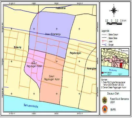
Social values found in community of Desa Pagubugan Kulon are regarded as social capital to establish desa tangguh bencana. According to Twigg [2007], community knowledge on disaster is one of desa tangguh bencana criterias. Furthermore, Twigg explains that one community comprehensively understand the hazard in their environment (see also Figure 1 for the location of Desa Pagubugan Kulon,
they will be able to adapt the situation.
According to the community, ‘We
understand that our two smallest settlement Units in the southern part are the most susceptible to the earthquake and tsunami. We plant coconut trees along the coastal area. We also propose the BPBD Kabupaten Cilacap to build sea wall in our beach.
Figure 1. Administration map of Desa Pagubungan Kulon, Kecamatan Binangun, Kabupaten Cilacap
Establishment of TLAGAMAS and its coordination system.
The socialisation of disaster management which is the basis of DRR campaign is not optimally carried by the local government or other institutions. The socialisation delivered by the outsider (researcher), has opened community insight on disaster topic. After having a series of socialisation and FGDs, the community of Desa Pagubungan Kulon declared themselves as TLAGAMAS (Tim Layanan SiaGA
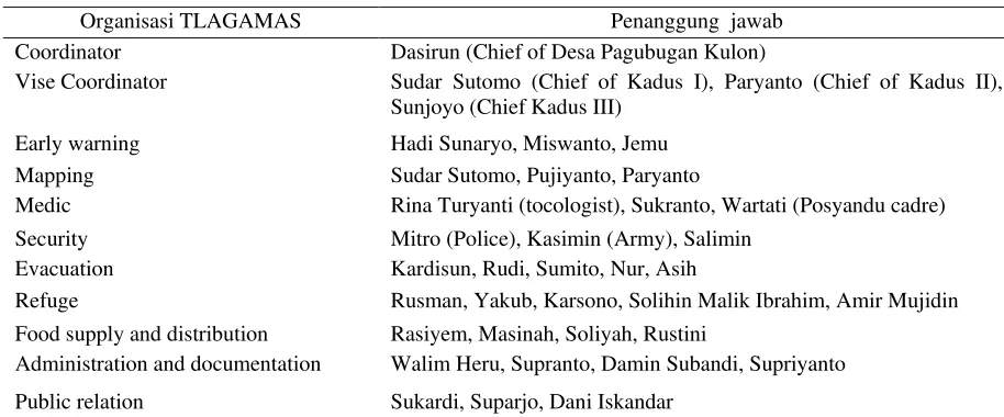
Bencana berbasis MASyarakat). In order to run TLAGAMAS systematically, structure of organisation, coordination system, and duties and function of each member were then set up. TLAGAMAS comprise several community elements such as government, civil security, youth forum, center for mother and child health, medical assistants, and civil society (see Tabel 1). The member of TLAGAMAS plays important role in reducing the disaster risk.
Table 1. Organisation structure of TLAGAMASDesa Pagubugan Kulon
Organisasi TLAGAMAS Penanggung jawab
Coordinator Dasirun (Chief of Desa Pagubugan Kulon)
Vise Coordinator Sudar Sutomo (Chief of Kadus I), Paryanto (Chief of Kadus II), Sunjoyo (Chief Kadus III)
Early warning Hadi Sunaryo, Miswanto, Jemu
Mapping Sudar Sutomo, Pujiyanto, Paryanto
Medic Rina Turyanti (tocologist), Sukranto, Wartati (Posyandu cadre)
Security Mitro (Police), Kasimin (Army), Salimin
Evacuation Kardisun, Rudi, Sumito, Nur, Asih
Refuge Rusman, Yakub, Karsono, Solihin Malik Ibrahim, Amir Mujidin
Food supply and distribution Rasiyem, Masinah, Soliyah, Rustini
Administration and documentation Walim Heru, Supranto, Damin Subandi, Supriyanto
Public relation Sukardi, Suparjo, Dani Iskandar
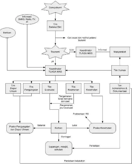
Every team in TLAGAMAS system has its own duty and function which has been set up to build strong institutional system. The forming of duty and function is carried out through several activities such as clarification of local institution, development of coordination system, and development of disaster management in local level. Clarification of local institution is aimed to identify the existing disaster management system by enhancing the supporting institutions. The development of disaster management in local level is carried out by setting a clear job description for every institution. In order to avoid overlapping duty and function, communication and coordination among the members are very important. The coordination system of TLAGAMAS is drawn in Figure 3.
Identifying safe area and mapping the evacuation route.
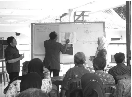
Community understands of disaster is not only translated into adaptive behaviour, but also ability to identify the safe area as
the basis of evacuation route mapping (see Figure 2. for the evacuation route mapping). Mapping safe area is also used to determine the location of paddy barn and logistic storehouse.
Figure 2. Participatory mapping to determine the evacuation route
Government set up the regulation on
CBDRR.
Development of Desa Pagubugan Kulon is focussed on three pillars, i.e. Infrastructure, Socio-culture, and Economic. Each of development pillars has its own priority in implementing the development plan. Development plan of Desa Pagubugan Kulon has basically included several pillars which can be used as the parameter of DRR. Policy on budgeting has not yet indicated the allocation for disaster preparedness and mitigation. Nevertheless, the development plan of Desa Pagubugan Kulon has mentioned several priorities which are related to disaster countermeasure, although they are still inclusive in other programmes.
Desa tangguh bencana is impossible to establish, unless initiation of this programme is carried out. Mapping the existing resources is the starting point toward desa tangguh bencana and substantially important to identify the factors of vulnerability and capacity. Strengthening community’s capacity both socially, economically, and environmentally is one of the priorities of in developing desa tangguh. The challenge that has to be faced by the outsiders is to deliver the disaster concept in simple and understandable way for the insiders. Disaster knowledge transfer is communication facility between outsiders and insiders. Successful risk communications can be carried out through gaming simulation (US Substance Abuse and Mental Health Services Admin, 2002 as cited by Abarquez dan Murshed, 2004).
Important aspect that has to be possessed by desa tangguh is legal entity which is translated in Peraturan Desa. Peraturan Desa regulates the disaster management and DRR activities in local level. The policy of budgeting to run the disaster management and DRR is regulated in Anggaran Pendapatan dan Belanja Daerah (APBD), Anggaran Pendapatan dan
Belanja Desa, and private sector. To be Pagubugan Kulon is to prepare the society living in disaster prone area. The initiation process has brought the community into TLAGAMAS with its coordination system and organisation structure. Community of Desa Pagubugan Kulon is now able to Desa Pagubugan Kulon is defined as desa tangguh pratama.
REFERENCES
Abarquez, I. Murshed, Z. (2004), Community Based Disaster Risk Management: Field Practitioner’s Handbook. ADPC.
BNPB (2011), Kunjungan Manager GFDRR ke BNPB. Diakses dari management in The Australian
Journal of Emergency
Management, 13(2): 2-5
Pusat Sudi Bencana (PSBA), Universitas Gadjah Mada, Yogyakarta. ISBN : 978-979-16011-7-7 (hal. 88-108)
Greiving, S. (2006), Multi-risk assessment
of Europe’s Region, in Birkmann, J. (Ed.), 2006, Measuring Vulnerability to Natural Hazards, Towards Disaster Resilient Societies, UNU-EHS, UNU-Press, Tokyo.
Kok, MTJ. and J. Jager. (2007), Vulnerability of People and the Environment – Challenges and Opportunities. UNEP.
Paripurno, ET. (2010), Bencana dan Peran Kita.
http://paripurno.blog.upnyk.ac.id/ diakses tanggal 12 November 2011.
Peraturan Desa Pagubugan Kulon No. 03/2010 tentang Rencana Pembangunan Jangka Menengah Desa (RPJM Desa) Tahun 2010 – 2014.
PP No. 64 Tahun 2010 tentang Mitigasi Bencana di Wilayah Pesisir dan Pulau-Pulau Kecil.
Pusat Studi Bencana (PSBA) (2007), Sosialisasi Mitigasi Bencana Gempabumi dan Tsunami di Pesisir Pantai Selatan Pulau Jawa, Laporan Akhir, Kerjasama antara PSBA UGM dengan Departemen Sosial RI, Yogyakarta.
Pusat Studi Bencana (PSBA). (2008), Kegiatan Pengurangan Risiko Bencana Alam dan Tsunami Wilayah Pantai Selatan Jawa, Laporan Akhir, Kerjasama antara PSBA UGM dengan Departemen Sosial RI, Yogyakarta.
Twigg, J. (2007), Characteristics of a Disaster Resilient Community: A Guidance Note. DFID, DRRICG.
Undang-Undang No. 24 Tahun 2007 tentang Penyelenggaraan Penanggulangan Bencana.
UNDP. (2004), Reducing Disaster Risk: A Challenge for Development. Global Report. UNDP, New York.
UNISDR. (2009), Terminology on Disaster Risk Reduction. UNISDR, Geneva.
US Department of Health and Human Services (2002), Communicating in a Crisis: Risk Communication Guidelines for Public Officials, Substance Abuse and Mental Health Services, Rockville, MD. Zamroni, I. (2011), Islam dan Kearifan
ISSN 0024-9521
IJG Vol. 44, No.2, December 2012 (183 - 194) © 2012 Faculty of Geography UGM and The Indonesian Geographers Association
LAND USE MODEL FOR BUILDING BASED ON CARRYING
CAPACITY OF CITY LAND (CASE STUDY: PALU CITY)
Amar
amarakbarali@gmail.com
Faculty of Engineering, Tadulako University
ABSTRACT
This study aims to model the growth trend of the extent of land use for building based on the carrying capacity of land in Palu city which is known as Bay City in accordance with the prediction of time. Methods of research were carried out with the approach of spatial and quantitative methods. The results show that Palu city as Bay City has the characteristics of urban land that is quite specific to the protected area. There is still available land for building i.e.: ± 13.151,13 ha (34.74%) with a growth rate of land use for building in the future 2.72% per year, area of cultivation will be fully filled in the year 2056 with the capacity of 1.052.730 people. Carrying capacity of land in Palu city until the year 2056 has not exceeded the threshold, either by the land consumption per capita or by the level density.
Keywords: land use, building, carrying capacity.
ABSTRAK
Penelitian ini bertujuan untuk memodelkan tren luas penggunaan lahan untuk bangunan berdasarkan karakteristik daya dukung lahan di kota Palu sebagai kota teluk sesuai dengan prediksi waktu. Penelitian dilakukan dengan pendekatan metode spasial dan kuantitatif. Hasil penelitian menunjukkan bahwa kota Palu sebagai kota teluk memiliki karakteristik lahan kota yang cukup spesifik dengan kawasan lindung mencapai hampir setengah dari total luas wilayahnya. Masih tersedia lahan untuk bangunan seluas: ± 13.151,13 ha (34.74%) dengan tingkat pertumbuhan penggunaan lahan untuk bangunan di masa akan datang sebesar 2,72% per tahun, maka kawasan budidaya belum terbangun akan penuh pada tahun 2056 dengan kapasitas 1.052.730 orang. Daya dukung lahan di kota Palu sampai tahun 2056 belum melampaui ambang batas, baik menurut konsumsi lahan per kapita maupun tingkat kepadatannya.
Kata kunci: penggunaan lahan, bangunan, daya dukung.
INTRODUCTION
Indonesia as a developing country still faces major problems in the development of cities. The development of economic activities and population growth which keep increasing will be followed by the demand of land, especially land for building as a place that holds a variety of urban activities such as housing and offices [Amar, et.al. 2011].
requirements (demand) in order not to exceed the carrying capacity of land. The population growth rate of Palu city from year to year has increased significantly on the number of people. In the period 2000 – 2010, the percentage rate of the population growth is in the average of 2.26% per annum with 336.532 people at the end of 2010 (The SP2010 number of buildings at the end of 2010 is ± 79.205 unit buildings with an extensive land use for building/yard and garden is ± 4.723,62 ha (12.48%), including urban infrastructure (primary survey, 2011). Besides the issue of increasing population and building, Palu city as bay city, by nature, also has ecological boundaries problems in the form of land availability which is a limiting factor for the development of the bay urban space, because the state of land resources are fixed (cannot be moved). Therefore, the land availability will determine wide distribution of the carrying capacity of space for land use in the Bay City [Amar, et.al. 2011)
Land use for building and ground which keep increasing, especially in the area of Palu, will cause problems later on. This is because of its limited land area, while the demand of land for building and yard always increases with the increasing population and urban activities, which at the certain times, the land in Palu city will be full of buildings.
THE METHODS
This study was conducted in Palu city towards population, families, hotel guests,
extensive areas/regions. The research data were in the form of primary data and secondary data which were categorized into two groups: spatial data and a spatial data. The research data were obtained through technique of survey, document noting and recording, mapping and satellite photo image digitization.
This study was carried out by using the approach and methods of quantitative spatial methods through several analytical techniques such as mapping analysis, namely an overlay technique and image analysis with the help of the GIS program to get the extensive availability of land, the regression analysis to see the growth trend of the extent of land use for building and the time limit of land available are capable of supporting the growth of the extent of land use for building, as well as analysis of the carrying capacity of land to see how much the capacity and the thresholds of the carrying capacity of land to the time limit of land availability for building.
RESULT AND DISCUSSION
Strategic Issues toward Regional Characteristics of Palu City
Due to having relevance to the issues and the objectives of the study conducted, discussion of strategic issues toward regional characteristic of Palu City is limited only to the physical and demographic characteristics as pointed out previously. Based on the above picture of the regional characteristic, it can be formulated that strategic issues taken into consideration in the structuring and developing of the Palu city in the future are as follows:
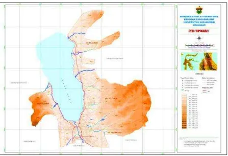
significant influence on the pattern of land use, where the availability of land for the cultivation area is only about 51.07% (± 19331.45 Ha) and the
protected area is approximately 48.93% (± 18529.38 ha) of the total area of land in Palu city (see Table 1 and Figure 1).
Table 1. Slope Classification of Palu City
Slope (%) Class Width (Ha) (%) Remarks
- 0 - - Waters
0 - <8 1 20,875.733 56.26 Flat
8 - <15 2 6,694.817 18.04 Sloping
15 - <25 3 5,157.395 13.90 Rather Steep
25 - <40 4 3,734.662 10.07 Steep
≥40 5 642.474 1.73 Very steep
Total 37,105.081 100.00
Source: Analysis Result of Delineation of Topographic Map, Palu City
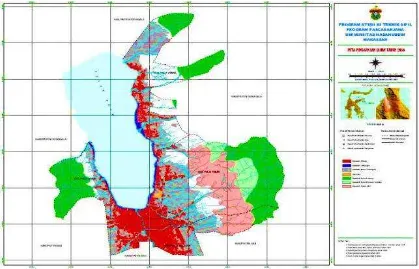
Figure 1. Map of Topographic of Palu City b. As the Bay City which has valley
shape and surrounded by the mountains, it makes Palu relatively crossed by the rivers and creeks which terminate into Palu bay, so that this condition can be used as a surface water source which is considerably potential for the needs of living things and activities of urban areas.
c. As a city that has three natural forces, namely mountains, rivers, and bay coasts, it makes of Palu as one of the exotic natural tourism cities becoming potential and prospective for the development as a tourist destination. It is through the planning of tourism infrastructure and the provision of tourist accommodate on with the
consideration to the carrying capacity and environmental quality (see Figure 2).
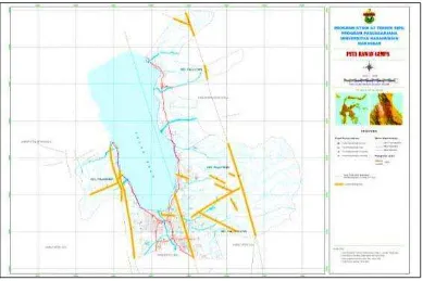
d. Asone of the cities passed by the fault line (Palu-Koro Fault) [Bellier, O. et al. 2001]; Palu city has relatively big
potential seismic and tsunami. This condition would be a serious concerning managing land use and technical feasibility of building to suit their quirements of zone and construction (see Figure 3).
Figure 2. Map of Land Use of Palu in 2010
e. As one of the cities located on the equator line, precisely located in the south line of the equator at coordinates 00,36”- 00,57” South Latitude (LS) and 1190,45”- 1200,01” East Longitude (BT), Palu city is a city that has the lowest rainfall categories when compared to other cities in Indonesia. In facing global climate change, this condition should be really paid attention when the opposite conditions occur, especially in anticipating the flood through the provision of land for green open spaces as the response to mitigation/disaster and environmental destruction.
f. As the capital of Central Sulawesi Province and the newly developing city, Palu will be the one of the alternative cities that is visited and inhabited if it is linked to public service and administration, and also business and creative opportunities. Characteristics of population growth
in Palu city are dominated by migrants (migration/urbanization), namely 82.32%, while natural growth (births minus deaths) is only 17.68%. This condition triggers a high growth of population for the last 30 years with a growth rate above 2.0% so it can be classified as the population explosion and also will have an impact on increasing to the demand for land.
Land Availability for Building
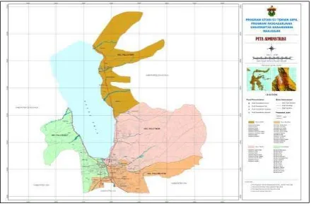
Spatially, the availability of land use for building to Palu area is ± 37.860,83 ha (see Figure 4). It can be done through an approach of overlay analysis technique to the base maps and thematic maps, which is derived both from the Bakosurtanal and RTRW Palu and from the results of digitization and classification of land use in image processing analysis. Based on spatial data processing, then it is obtained a map of the distribution and availability of land for building in Palu city, as shown on the map in Figure 5.
Figure 4. Map of Administration and Area of Palu City
Picture 5. Map of Land Availability for Building in Palu City Furthermore, land use maps quantitatively
obtained from spatial data processing can also be tabulated and grouped by type and area of each land use area, including: protected area (KL) is ± 18529.38 Ha;
developed cultivation area (KBT) is ±
4180.25 Ha; urban infrastructure area (KPK) is ± 543.27 ha; and strategic area of
city (KSK) is ± 1456.80 Ha, so the
extensive availability of land for building can be calculated in accordance with the needs of mathematical model equation:
The analysis shows that there are±
13.151,13 Haof land classified as land for cultivation activities, including the establishment of building. It is the biophysical land, especially from slope and topography aspects which are suitable to be used and developed as land for various cultivation activities [Amar, et al. 2012].
Relation Model of the Extent of land use for Timing Building for Future Time
The Equation of the Number of Land Users for Building in Palu
The equation of the population number and the number of families is classified on the total number, while the equations of the number of hotel guests consists of star hotel guests and non-star hotel guests and other accommodations. The equations obtained from regression method are changed from period to A.D. calendar/ year.
a. The Equation of the Population Number of Palu
Pjpk = 261.996,9824 e 0,0244 (t – 1999)
R2 = 0,9749
b. The Equation of the Population Number of Central Sulawesi Province Pjpp = 2.136.910,1758 e 0,0192 (t – 1999)
R2 = 0,9998
c. The Equation of The Number of Families of Palu
d. The Equation of the Number of Star Restaurants and Restaurant Seats in Palu
Pkrm = 2.135,6250 e 0,1184 (t – 2001)
R2 = 0,4826
The Extent of Land Use by One User for Building
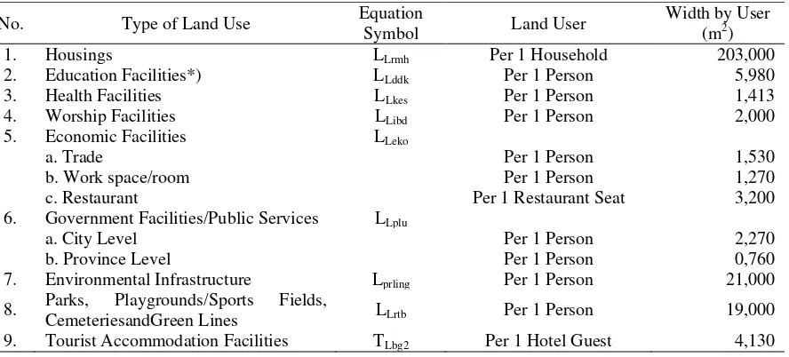
Overall, the extensive land use by one user for building in Palu city can be seen in Table 2.
Table 2. The extensive land use by one user for building in Palu
No. Type of Land Use Equation
5. Economic Facilities LLeko
a. Trade Per 1 Person 1,530
b. Work space/room Per 1 Person 1,270
c. Restaurant Per 1 Restaurant Seat 3,200
6. Government Facilities/Public Services LLplu
a. City Level Per 1 Person 2,270
b. Province Level Per 1 Person 0,760
7. Environmental Infrastructure Lprling Per 1 Person 21,000
8. Parks, Playgrounds/Sports Fields,
CemeteriesandGreen Lines LLrtb Per 1 Person 19,000
9. Tourist Accommodation Facilities TLbg2 Per 1 Hotel Guest 4,130
Source : Analysis Result of Researcher, 2011
*) dosen not include an area of higher education facilities
The Equation of the Extent of Land Use for Building
The equation of the extent of land use for building is the multiplication of the extent of land use by one user with the equation of the number of users. The extent of land use by one user from year to year is fixed. The equation of the number of users and the extent of land use by one user is already obtained in the previous stage. a. The Equation of The extent of land
use for Settlement
1) Land Use for Housings:
LLrmh = 1.109,7405,41 e0,0306 (t – 1999)
Ha
2) Land Use for Educational Facilities:
LLddk = 156,6741954752 e0,0244 (t – 1999)
+ 299,8 Ha
3) Land Use for Health Facilities: LLkes = 37,02017361312 e0,0244 (t – 1999)
Ha
4) Land Use for the Worship Facilities:
LLibd = 52,39939648 e0,0244 (t – 1999)
Ha
5) Land Use for Economic Facilities: 6) Land Use for Government
Facilities and Public Services:
LLplu = 59,473315005 e0,0244 (t – 1999)
Ha + 162,405173361 e 0,0192 (t – 1999)
Ha
7) Land Use for Environmental Infrastructure:
Lprling = 550,19366304 e0,0244 (t – 1999)
Ha
8) Land Use for Parks, Playgrounds / Sports Fields, Cemeteries and Green Lines:
LLrtb = 497,79426656 e0,0244 (t – 1999)
Ha
9) Total Area of Land Use for Settlement in Palu(TLbg1) :
TLbg1 = (1.109,740541 e0,0306 (t –
b. The Equation of the Area of Land Use for Tourist Accommodation Facilities
2) The use for non-star hotel and other accommodations:
c. Total Area of Land Use for Building in Palu
Total area of land use for building in Palu city is the accumulation of total land use for settlement and tourist accommodation facilities by using the following equation: T = [{(1.109,7405,41 e 0,0306 (t – 1999)) + for settlement and tourist accommodation facilities in Palu city is based on 5-year period of the extent of land use from 2015 to 2100 resulting from equation (18). Based on this equation, the extent of land use for building is 4.531,8520 Ha for the year 2015 (period 1), and 43.218,9591 Ha for the year 2100 (period 18). The growth rate of land use for building is calculated based on the discreate growth method of land use for building as follows:
Pt = P0 ( 1 + r )t
r = the average of the increasing proportion of land use every year.
43.218,9591 = 4.531,8520 ( 1 + r )84
The growth rate of land use for building in Palu city is 2.72% per year.
Figure 6. Shows graph showing the relationship between the extent of land use for building and the extent of available land in undeveloped cultivation area in Palu city.
Time Limit of Land Availability which is Capable of Supporting the Growth Area of Land Use for Building
b. The time limit for the tourist accommodation facilities in Palu city is able to support the growth of land use for building under the direction of the type and the extent of land use ± 263, 02 Ha until the year 2052.
The time limit for the undeveloped cultivation areas in Palu city is capable of
supporting the growth of land use for the building under the direction of the type and the extent of land use ± 13.151,13 Ha until the year 2056. Figure 7. shows map of land use for building in Palu city in year 2056.
Figure 6. Graph showing the relationship between the extent of land use for building and the extent of available land in undeveloped cultivation area in Palu city
Figure 7. Map of land use for building in Palu city in year 2056 Source : Analysis Result of Researcher, 2011
The Carrying Capacity of Land for
Building which is Capable of
Accommodating the Population Growth of Palu
a. The land capacity for settlement area in accordance with the time limit until the year 2055 with the land availability of ±12.493, 57 Ha is 1.027.354 people and the household capacity in settlement area of ±6.188, 0816 Ha is 303.345 households. b. The capacity for tourist
accommodation in accordance with the time limit until the year 2052 with the land availability of ±263, 02 Ha is 59.273 star hotel guests, as well as the capacity for non-star hotels and other accommodations in tourist accommodation facilities area of ±263.02 Ha is 585 362 non-star hotel guests and other accommodations. c. The capacity for the undeveloped
cultivation area in accordance with the time limit until the year 2056 with the land availability of ±13.151, 13 Ha is 1.052.730 people. per capita for 1.052.730 people should be ± 0,061 Ha/person.
While the carrying capacity threshold of land according to the population density is: 1.052.730 people/ ± 13151.13 Ha =80 people/Ha.
Based on the classification of the population density of urban settlement, the calculation result is still relatively low.
Efforts in dealing with the Land Use for Building
Based on the equation model for the extent of land use for building and the calculation of the carrying capacity of land in Palu city as bay city, then it is required some efforts to be able to support the growth of the extensive of land use for building longer in accordance with the carrying capacity, among others: a) improving efficiency of the extent of land use for building by one user; b) controlling population growth; c) increasing the extent of land for building, and d) developing multi-stories building.
CONCLUSION
a. Palu has regional characteristic which is quite specific and its protected area attains almost half of the total land area ±18.529, 38 Ha (48.94%) and the rest is cultivated area ± 19.331,45 Ha (51.06%).
b. The extent of land use for building in Palu in future has increased with the growth rate 2.72% per year.
c. The time limit for the settlement area is capable of supporting the growth of land use for building ± 12.493,57 Ha until the year 2055 with a capacity of 1.027,354 people and 303. 345 households. The time limit for the tourist accommodation is capable of supporting the growth of land use for the building ± 263, 02 Ha until the year 2052 with a capacity of 59.273 star-hotel guests and 585.362 non-star hotel guests and other accommodations. At the same time, the time limit for undeveloped cultivation area is capable of supporting the growth of land use for building ± 13.151,13 Ha until the year 2056 with a capacity of 1.052.730 people.
environmental carrying capacity thresholds.
e. Efforts needed to support the growth of the extent of land use for building in Palu city becoming longer are: to do the efficiency for the extent of land use for building by one user; to control the population growth; to increase the extent of land for building; and to develop multi-stories building.
REFERENCES
Amar, Selintung Mary, Barkey, Roland A., dan Thaha, M. Arsyad, (2012), Land Availability Analysis for Building Based On Land Characteristic of Palu City. International Journal of Civil & Environmental Engineering IJCEE-IJENS. 12(01): 70 – 80. ISSN: 2077-1258.
Amar, Selintung Mary, Barkey, Roland A, dan Thaha, M. Arsyad, (2011), Land Use Spatial Model for Building Based on Availability and Capacity of Land in Territory of Coastal City (Case Study: Palu City). Proceedings of the Sixth International Conference on Asian and Pacific Coasts (APAC 2011) December 14 – 16, 2011, Hong Kong, China. p. 517 – 524. ISBN: 978-981-4366-47-2.
Amar, Mary Selintung, Roland A. Barkey, dan M. Arsyad Thaha. (2011), Study of Land Capability to the Need of Land Use for Building Growth in Palu City. Paper International Seminar Geospatial and Human Dimension of Sustainable Natural Resource Management. IPB International Convention Centre. Bogor - Indonesia 12 – 13 September 2011.
Bellier, O. et al. (2001), High slip rate for a low seismicity along the Palu-Koro active fault in central Sulawesi .Terra Nova, 13(6): 463 – 470.
Briassoulis, H. (2002), Analysis of land Use Change, Theoretical and Modeling Approaches. Regional Research Institute, West Virginia University.http://www.rri.wvu.edu/W ebBook/Briassoulis/content.htm. Fatimah, Endrawati. (2011),
Keberlanjutan Pembangunan Kota Dilandasi Daya Dukung Lingkungan. Bunga Rampai Pembangunan Kota Indonesia dalam Abad 21: Konsep dan Pendekatan Pembangunan Perkotaan di Indonesia. Edisi 2. Yayasan Sugijanto Soegijoko URDI. Jakarta. Hasni. (2010), Hukum Penataan Ruang
dan Penatagunaan Tanah Dalam Konteks UUPA-UUPR-UUPLH. Rajawali Pers. PT. Rajagrafindo Persada, Jakarta.
Heung, Ivy. (2002), Land Capacity Analysis. Planning Quarterly– September 2002, Wellington City Council.
Jayadinata, J.T. (1999), Tata Guna Tanah dalam Perencanaan Perdesaan Perkotaan & Wilayah, Bandung: ITB.
Lambin, E.F. H.J. Geist, and E. Lepers. Interpretation. 4th Edition. John Wiley and Sons, Inc.
Murai, Shunji. (2008), Pengantar GIS, Tokyo University, terjemahan oleh Tri AgusPrayitnohttp://www.geografiana. com/makalah/teknologi/bab-i-gis-workbook-vol-i-pengantar-gis, diakses Pebruari 2008.
Neufert, Ernst. (1980), Architects’ Data. New International Edition.Granada
Publishing. Halsted Press John Wiley & Sons. Inc. New York.
Sudipta, I Gusti Ketut, dkk. (2008), Model Penggunaan Lahan Untuk Bangunan Di Wilayah Perkotaan Provinsi Bali, Jurnal Ilmiah Teknik Sipil, 12(2): 153 – 164.
Steinnocher, K. (1996), Integration of Spectral and Spatial Classification Methods for Building A Land-Use Model of Austria. International Archives of Photogrammetry and Remote Sensing, 31(IV):841-846,
Vienna. Departemen for
Environmental Planning Austrian Research Centre Seibersdorf, 2444 Seibersdorf.
