Open Geospatial Consortium
Publication Date: 2014-07-16 Approval Date: 2014-06-14 Posted Date: 2014-05-16
Reference number of this document: OGC 14-048
Reference URL for this document: http://www.opengeospatial.net/doc/PER/testbed10/cci-hydro-model
Category: Public Engineering Report
Editor(s): Genong (Eugene) Yu, Liping Di
OGC
®Testbed 10 Cross Community Interoperability (CCI)
Hydro Model Interoperability Engineering Report
Copyright © 2014 Open Geospatial Consortium.
To obtain additional rights of use, visit http://www.opengeospatial.org/legal/.
Warning
This document is not an OGC Standard. This document is an OGC Public
Engineering Report created as a deliverable in an OGC Interoperability Initiative and is not an official position of the OGC membership. It is distributed for review and comment. It is subject to change without notice and may not be referred to as an OGC Standard. Further, any OGC Engineering Report should not be referenced
as required or mandatory technology in procurements.
Document type: OGC® Engineering Report
Document subtype: NA
Abstract
This OGC® document gives guidelines for enabling interoperability among different hydro data models and services. The demonstration specifically gives out best practices for supporting interoperability among the National Hydrographic Network (NHN) of Canada, the National Hydrographic Dataset Plus (NHD+) of United States, and the OGC HY_Features model developed and proposed by the World Meteorological Organization (WMO). The discussed version of OGC HY_Features was adopted as the mediation bridge model to exchange information among heterogeneous hydrological models.
Keywords
ogcdoc, ogc documents, testbed10, cci, hydrology, modeling, hy_features, waterml, riverml, semantic mediation
Preface
License Agreement
Permission is hereby granted by the Open Geospatial Consortium, ("Licensor"), free of charge and subject to the terms set forth below, to any person obtaining a copy of this Intellectual Property and any associated documentation, to deal in the Intellectual Property without restriction (except as set forth below), including without limitation the rights to implement, use, copy, modify, merge, publish, distribute, and/or sublicense copies of the Intellectual Property, and to permit persons to whom the Intellectual Property is furnished to do so, provided that all copyright notices on the intellectual property are retained intact and that each person to whom the Intellectual Property is furnished agrees to the terms of this Agreement.
If you modify the Intellectual Property, all copies of the modified Intellectual Property must include, in addition to the above copyright notice, a notice that the Intellectual Property includes modifications that have not been approved or adopted by LICENSOR. THIS LICENSE IS A COPYRIGHT LICENSE ONLY, AND DOES NOT CONVEY ANY RIGHTS UNDER ANY PATENTS THAT MAY BE IN FORCE ANYWHERE IN THE WORLD.
THE INTELLECTUAL PROPERTY IS PROVIDED "AS IS", WITHOUT WARRANTY OF ANY KIND, EXPRESS OR IMPLIED, INCLUDING BUT NOT LIMITED TO THE WARRANTIES OF MERCHANTABILITY, FITNESS FOR A PARTICULAR PURPOSE, AND NONINFRINGEMENT OF THIRD PARTY RIGHTS. THE COPYRIGHT HOLDER OR HOLDERS INCLUDED IN THIS NOTICE DO NOT WARRANT THAT THE FUNCTIONS CONTAINED IN THE INTELLECTUAL PROPERTY WILL MEET YOUR REQUIREMENTS OR THAT THE OPERATION OF THE INTELLECTUAL PROPERTY WILL BE
UNINTERRUPTED OR ERROR FREE. ANY USE OF THE INTELLECTUAL PROPERTY SHALL BE MADE ENTIRELY AT THE USER’S OWN RISK. IN NO EVENT SHALL THE COPYRIGHT HOLDER OR ANY CONTRIBUTOR OF
INTELLECTUAL PROPERTY RIGHTS TO THE INTELLECTUAL PROPERTY BE LIABLE FOR ANY CLAIM, OR ANY DIRECT, SPECIAL, INDIRECT OR CONSEQUENTIAL DAMAGES, OR ANY DAMAGES WHATSOEVER RESULTING FROM ANY ALLEGED INFRINGEMENT OR ANY LOSS OF USE, DATA OR PROFITS, WHETHER IN AN ACTION OF CONTRACT, NEGLIGENCE OR UNDER ANY OTHER LEGAL THEORY, ARISING OUT OF OR IN CONNECTION WITH THE IMPLEMENTATION, USE, COMMERCIALIZATION OR PERFORMANCE OF THIS INTELLECTUAL PROPERTY. This license is effective until terminated. You may terminate it at any time by destroying the Intellectual Property together with all copies in any form. The license will also terminate if you fail to comply with any term or condition of this Agreement. Except as provided in the following sentence, no such termination of this license shall require the termination of any third party end-user sublicense to the Intellectual Property which is in force as of the date of notice of such termination. In addition, should the Intellectual Property, or the operation of the Intellectual Property, infringe, or in LICENSOR’s sole opinion be likely to infringe, any patent, copyright, trademark or other right of a third party, you agree that LICENSOR, in its sole discretion, may terminate this license without any compensation or liability to you, your licensees or any other party. You agree upon termination of any kind to destroy or cause to be destroyed the Intellectual Property together with all copies in any form, whether held by you or by any third party. Except as contained in this notice, the name of LICENSOR or of any other holder of a copyright in all or part of the Intellectual Property shall not be used in advertising or otherwise to promote the sale, use or other dealings in this Intellectual Property without prior written authorization of LICENSOR or such copyright holder. LICENSOR is and shall at all times be the sole entity that may authorize you or any third party to use certification marks, trademarks or other special designations to indicate compliance with any LICENSOR standards or specifications.
This Agreement is governed by the laws of the Commonwealth of Massachusetts. The application to this Agreement of the United Nations Convention on Contracts for the International Sale of Goods is hereby expressly excluded. In the event any provision of this Agreement shall be deemed unenforceable, void or invalid, such provision shall be modified so as to make it valid and enforceable, and as so modified the entire Agreement shall remain in full force and effect. No decision, action or inaction by LICENSOR shall be construed to be a waiver of any rights or remedies available to it.
Contents
Page1 Introduction ... 1
1.1 Scope ... 1
1.2 Document contributor contact points ... 1
1.3 Future work ... 2
6 Hydro model interoperability ... 7
6.1 Data and model resources ... 7
6.1.1 Data access services ... 7
6.1.1.1 Spatial feature data ... 7
6.1.1.2 Observation data ... 9
6.1.2 Information models ... 9
6.1.2.1 Conformance to ISO 19103 and ISO 19109 ... 9
6.1.2.2 Semantic feature type catalog ... 9
6.1.2.3 HY_Features common hydrological feature model ... 10
6.1.2.4 WaterML 2 model ... 11
6.1.2.5 RiverML model ... 11
6.1.2.6 NHD+ model ... 11
6.1.2.7 NHN model ... 11
6.2 Semantic mapping of hydrological models ... 12
6.2.1 Semantic mapping implementation in the Testbed-10 ... 16
6.2.2 NHD+ / NHN source models and HY_Features ... 17
6.3 Mediation system implementation ... 19
6.3.1 Overall system architecutre ... 19
6.3.2 Service components ... 21
6.3.2.1 Hydro model mediator ... 21
6.3.2.2 Hydro model service ... 21
6.3.3 Backend communication between service components ... 22
6.3.4 Mapping implementation using xlink ... 23
6.3.5 Semantic mapping implementation and example queries ... 25
6.4 Use cases ... 27
6.4.1 Use case 1: Mapping hydrographic features from NHD+ to HY_Features ... 27
6.4.1.1 Description ... 27
6.4.1.2 Demonstration ... 29
6.4.2 Use case 2: Mapping hydrographic features from NHN to HY_Features ... 32
6.4.2.1 Description ... 32
6.4.2.2 Demonstration ... 33
6.4.3 Use case 3: Hydrographic mapping between NHD+ and NHN ... 36
6.4.3.1 Description ... 36
6.4.3.2 Demonstration ... 38
6.4.4 Use case 4: Finding upstream service ... 39
6.4.4.1 Description ... 39
6.4.4.2 Demonstration ... 41
6.4.5 Use case 5: Heterogeneous hydrological model integration mapping (NHN/NHD+) ... 43
6.4.5.1 Description ... 43
6.4.5.2 Demonstration ... 47
7 Best Practices ... 51
7.1 Access hydrologic from multiple data sources ... 51
7.2 Mediation between hydrologic models ... 52
7.3 Mediation power of the HY_Features model ... 53
7.4 Best practices for a hydro model mediation system ... 54
Bibliography ... 56
7.5 Revision history ... 57
Figures
Page Figure 1 — Overall Architecture ... 7Figure 2 — Mapping framework ... 13
Figure 3 — NHD_Flowline - Mapping NHD_HydroElement to HY_FlowPath ... 14
Figure 4 — NHN_Flowline - Mapping NHN_nlflow to HY_FlowPath ... 15
Figure 6 — Conceptual Model Structure: HY_Features ... 17
Figure 7 —Data Model Structure: NHD+ ... 18
Figure 8 — Data Model Structure: NHN ... 19
Figure 9 — Overall Architecture ... 20
Figure 10 — Interactions between component services ... 21
Figure 11 — Service Communication ... 22
Figure 12 — Flow line mapping using Xlink ... 25
Figure 18 — Use case 1 step 2: Retrieve results in HY_Features ... 31
Figure 19. Result of the query in Table 5 ... 31
Figure 20 — Use case 2: Mapping flow line from NHN to HY_Features ... 33
Figure 21 — Use case 2 step 1: Define an area of interest In Canada ... 34
Figure 22 — Use case 2 step 2: Retrieve results in HY_Features ... 35
Figure 23. Result of the query in Table 6 ... 35
Figure 29 — Use case 4 demo: Result feature collection in NHN model ... 43
Figure 30 — Use Case 5: Hydrographic Mapping of Heterogeneous Hydro Models ... 45
Figure 31 — Use Case 5: Cross Model Framework ... 46
Figure 32 — Use Case 5: Cross Model Data Matching ... 47
Figure 33 — Use case 5 demo: Selecting a cross-border AOI ... 48
Figure 34 — Use case 5 demo: Merged features in HY_Features model ... 49
Figure 35 — Use case 5 demo: Merged features in NHD+ model ... 50
Figure 36. Result of the query in Table 7 ... 51
Table 1 — Contents of data dictionary tables ... 5
Table 2. An example query to find the entities in HY_Features ... 26
Table 3. An example query to find the fields of HY_FlowPath in HY_Features model ... 26
Table 4. An example query to find the models to be mapped from HY_FlowPath in HY_Features model ... 27
Table 5. An example query to find the mapping of HY_FlowPath to NHD+ ... 31
Table 6. An example query to find the mapping of HY_FlowPath to NHN ... 35
OGC
®Testbed 10 Cross Community Interoperability (CCI)
Hydro Model Interoperability Engineering Report
1 Introduction
1.1 Scope
The scope of this Engineering Report is to capture advancements, best practices, standard adoption, specification change requests, and interoperability surrounding the Hydro Model Interoperability work. The work is a sub-task under the Cross-Community Interoperability (CCI) thread of the OGC Testbed 10 within the Interoperability Program. The effort focuses on demonstrating interoperability among hydrographic and hydrologic data sources. It bears the similar scope of CCI but a narrow subject on hydro models and services. The ultimate goal is to build on interoperability within hydro communities sharing geospatial data and advance semantic mediation approaches for data discovery, access, and use of heterogeneous hydro data models and heterogeneous hydro metadata models.
This OGC® document gives guidelines for enabling interoperability among different hydro data models and services. The demonstration specifically gives out best practices for supporting interoperability among the National Hydrographic Network (NHN) of Canada, the National Hydrographic Dataset Plus (NHD+) of United States, and the OGC HY_Features model developed and proposed by the World Meteorological Organization (WMO). The discussed version of OGC HY_Features was adopted as the mediation bridge model to exchange information among heterogeneous hydrological models.
This OGC® document is applicable to hydro model and service interoperability adopting emerging OGC specification – HY_Features.
1.2 Document contributor contact points
All questions regarding this document should be directed to the editor or the contributors:
Name Organization
Genong (Eugene) Yu George Mason University, [email protected] Liping Di George Mason University, [email protected] Chenyu Hao GIS.FCU, [email protected]
Rob Atkinson CSIRO, [email protected]
1.3 Future work
Hydrological data and model integration requires not only reconciliation of variations in geometric mapping but also semantic mapping of data structures and content values. Semantic mapping is a complex process, often performed in data preparation activities in different systems and processes in different ways. In the Testbed-10 a prototype mapping was designed and tested to link hydrological information models of different design but comparable semantics. From the experience of this test bed, the following further work is recommended.
Semantic support for mediation – The prototype implementation was initially
using xlink to achieve the mapping between different models. The major reasons are the existing knowledge and technology of the implementation organization and the easy use of xlink technology for the purpose of rapid development. The semantic mapping was tested using a prototype knowledgebase developed and implemented in OWL using Protégé editor. The knowledgebase was released for testing through a standard SPARQL engine. The demonstration has limited use of features and examples to mapping the hydrological features across models and therefore the use of semantic mapping is also limited on equivalences. In reality, semantic mapping does not stop on just equivalence of single properties, but may include more complex overlapping semantics of different groups of properties. The further requirements of semantic mapping in depth may call for a semantic mapping technology other than simple equivalence. Along the line of both geographic and semantic matching, the use of GeoSPARQL with the topological relationship defined in the HY_Features model may be further tested.
Standards based persistent hydrologic feature data access – The
demonstration in the Testbed-10 did not present the data in a standards based persistent data service, such as Web Feature Service (WFS). Non-standard access methods lead to a fragile and limited-scope solution, typically bound to a specific version of specific software. In order to serve hydrological features in a WFS, hydrology-specific application schemas are required. These should be grounded in the common concepts of the HY_Features model..
Semantic mapping framework conforms to ISO baselines – The lack of a
integration. This would also limit the interoperability and reusability of semantic mapping tools and frameworks. The purpose of frameworks is to support the semantic mapping process with either re-usable tools or pre-tested mappings of some components. It was recommended that such a mapping framework should conform to the ISO baselines, particularly the evolving ISO19150-2 standard[1], for encoding application schema in Resource Description Framework (RDF). This is important because it provides for a unique, resolvable identifier for each model element participating in semantic mappings. . It was also recommended that OGC take further steps to explore how to encapsulate the complexity of the problem by identification of common patterns, promulgating exemplar mappings supporting the development of appropriate tooling to make it a sustainable process. For example, the community would benefit from reusable or example semantic mappings based on the Observation and Measurements abstract model (ISO 19156) to typical implementation models such as NetCDF. The example use cases of this test bed are suggested as a test case for a future standardization activity for model mapping frameworks.
1.4 Forward
Attention is drawn to the possibility that some of the elements of this document may be the subject of patent rights. The Open Geospatial Consortium shall not be held responsible for identifying any or all such patent rights.
Recipients of this document are requested to submit, with their comments, notification of any relevant patent claims or other intellectual property rights of which they may be aware that might be infringed by any implementation of the standard set forth in this document, and to provide supporting documentation.
2 References
The following documents are referenced in this document. For dated references, subsequent amendments to, or revisions of, any of these publications do not apply. For undated references, the latest edition of the normative document referred to applies. OGC 06-121r3, OGC® Web Services Common Standard
OGC 11-052r4, OGC® GeoSPARQL - A Geographic Query Language for RDF Data
OGC 11-039r3, OGC® HY_Features: a Common Hydrological Feature Model Discussion Paper
OGC 08-126, The OGC® Abstract Specification Topic 5: Features
OGC 99-110, The OGC® Abstract Specification Topic 10: Feature Collections
OGC 99-114, The OGC® Abstract Specification Topic 14: Semantics and Information Communities
OGC 05-007r7, OGC® Web Processing Service
OGC 09-025r1, OGC® Web Feature Service 2.0 Interface Standard
ISO 19142:2010, Geographic information -- Web Feature Service
OGC 04-094, OGC® Web Feature Service (WFS) Implementation Specification
NOTE This OWS Common Standard contains a list of normative references that are also applicable to this Implementation Standard.
In addition to this document, this report includes several XML Schema Document files as specified in Annex A.
3 Terms and definitions
For the purposes of this report, the definitions specified in Clause 4 of the OWS Common Implementation Standard [OGC 06-121r3] and in OGC® Abstract Specification Topic 5: Features [OGC 08-126], Topic 10: Feature Collection [OGC 99-110], Topic 12: The OGC Service Architecture [OGC 02-112], and Topic 14: Semantics and Information Communities [OGC 99-114] shall apply. In addition, the following terms and definitions apply.
3.1 HY_Features
HY_Features is a hydrologic feature model developed in the joint WMO/OGC Hydrology Domain Working Group [OGC 11-039r3].
3.2 National Hydrographic Network
Its acronym is NHN. It is a hydro model developed and used in Canada.
3.3 National Hydrographic Dataset Plus
Its acronym is NHD+. It is a hydro model developed and used in United States.
NOTE NHD+ and NHD are used interchangeable in the context of this report.
4 Conventions
4.1 Abbreviated terms
NHD+ National Hydrographic Dataset Plus NHN National Hydrographic Network WFS Web Feature Service
WPS Web Processing Service
4.2 UML notation
Most diagrams that appear in this standard are presented using the Unified Modeling Language (UML) static structure diagram, as described in Subclause 5.2 of [OGC 06-121r3].
4.3 Used parts of other documents
This document uses significant parts of document [OGC 06-121r3]. To reduce the need to refer to that document, this document copies some of those parts with small modifications. To indicate those parts to readers of this document, the largely copied parts are shown with a light grey background (15%).
4.4 Data dictionary tables
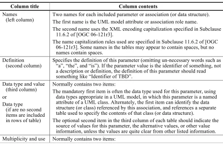
The UML model data dictionary is specified herein in a series of tables. The contents of the columns in these tables are described in Table 1.
Table 1 — Contents of data dictionary tables
Column title Column contents
Names (left column)
Two names for each included parameter or association (or data structure). The first name is the UML model attribute or association role name.
The second name uses the XML encoding capitalization specified in Subclause 11.6.2 of [OGC 06-121r3].
The name capitalization rules used are specified in Subclause 11.6.2 of [OGC 06-121r3]. Some names in the tables may appear to contain spaces, but no names contain spaces.
Definition (second column)
Specifies the definition of this parameter (omitting un-necessary words such as “a”, “the”, and “is”). If the parameter value is the identifier of something, not a description or definition, the definition of this parameter should read something like “Identifier of TBD”.
Data type and value (third column)
Normally contains two items:
The mandatory first item is often the data type used for this parameter, using data types appropriate in a UML model, in which this parameter is a named attribute of a UML class. Alternately, the first item can identify the data structure (or class) referenced by this association, and references a separate table used to specify the contents of that class (or data structure).
Column title Column contents
The mandatory first item specifies the multiplicity and optionality of this parameter in this data structure, either “One (mandatory)”, “One or more (mandatory)”, “Zero or one (optional)”, or “Zero or more (optional)”. The second item in the right column of each table should specify how any
multiplicity other than “One (mandatory)” shall be used. If that parameter is optional, under what condition(s) shall that parameter be included or not included? If that parameter can be repeated, for what is that parameter repeated?
When the data type used for this parameter, in the third column of such a table, is an enumeration or code list, all the values specified shall be listed, together with the meaning of each value. When this information is extensive, these values and meanings should be specified in a separate table that is referenced in the third column of this table row.
The data type of many parameters, in the third table column, is specified as “Character String type, not empty”. In the XML Schema Documents specified herein, these parameters are encoded with the xsd:string type, which does NOT require that these strings not be empty.
The contents of these data dictionary tables are normative, including any table footnotes.
4.5 Use of term NHD+ and NHD
For the convenience of diagram and description, NHD is used interchangeable with NHD+ to mean the hydro model currently used in USA. In text, NHD+ is used to represent the current hydro model used in US. In diagrams and some text, NHD is used to indicate the same model but for simplicity without using special “+” sign.
5 Hydro modelingoverview
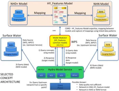
The specified Hydro Model Interoperability task addresses the interoperability among heterogeneous hydrographic and hydrologic data sources through adopting the HY_Features common hydrologic feature model. It is part of the Cross-Community Interoperability (CCI) Thread. The Testbed-10 seeks to specifically answer the following questions:
(1) How does the HY_Features model enable access to hydro data from multiple sources?
(2) How does the HY_Features model help the mediation between different hydro conceptual feature models?
(4) What are the best practices to build a hydrographic and hydrologic data source mediation system based on the HY_Features model to support interoperability across jurisdictions, between various data models, and data structures?
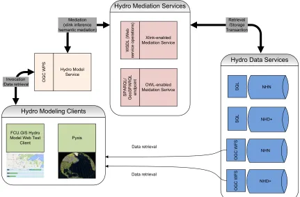
In answering these questions, the following overall architecture has emerged during the Testbed-10 as shown in Figure 1.
Figure 1 — Overall Architecture
6 Hydro model interoperability
6.1 Data and model resources
6.1.1 Data access services
6.1.1.1 Spatial feature data
NHD+, or NHDPlus, is an integrated set of application-ready geospatial data sets that incorporates features from the National Hydrography Dataset (NHD), the National Elevation Dataset (NED), and the Watershed Boundary Dataset (WBD)[7]. The NHD+ Flow Lines, catchments, and watershed boundaries are available packaged with numerous other data products from: ftp://ftp.horizon-systems.com/NHDPlus/NHDPlusV21/Data/ . Metadata for these are available from:
ftp://ftp.horizon-systems.com/NHDPlus/NHDPlusV21/Documentation/NHDPlusV2_Metadata.7z NHD data access can be accomplished by five approaches online:
(1) Access data through an online order system – http://nhd.usgs.gov/data.html. The order would be usually gone through the packaging process and delivery in 1 or 2 hours.
(2) Direct access to sub-regions identified by 4-digit identification number. This can be accomplished by using NHD Viewer (http://viewer.nationalmap.gov/viewer/).
(3) Download the data by state from the ftp site -
ftp://nhdftp.usgs.gov/DataSets/Staged/States/FileGDB
(4) Extract subset data of only Streamgages and Dams obtainable from
ftp://nhdftp.usgs.gov/DataSets/National
(5) Watershed boundaries can be download from NRCS Geospatial Data Gateway (http://datagateway.nrcs.usda.gov/)
NHD+ data can be downloaded from
http://www.horizon-systems.com/NHDPlus/V2NationalData.php by either http download or ftp download. The test dataset for the Red River can be downloaded at: ftp://ftp.horizon-systems.com/NHDPlus/NHDPlusV21/Data/NHDPlusSR/, where the NHDSnapshot (i.e. NHDSnapshot 04.7z) contains flowlines. The test dataset for the Great Lakes can be
downloaded at:
ftp://ftp.horizon-systems.com/NHDPlus/NHDPlusV21/Data/NHDPlusGL/.
The USGS National Water Census will be publishing WFS services for the NHD+ verison 2 Flowlines, catchments (One per flowline), and corresponding HUC12 watersheds (common aggregations of catchments). These services are not available at the time of this demonstration work. Therefore, the dataset are directly retrieved from the website through ftp or http download.
http://www.geobase.ca/geobase/en/find.do?produit=nhn
They are served online via three options to be accessed:
(1) By querying for a specific NHN Work Unit, for example, 05OB000, interactively through
http://www.geobase.ca/geobase/en/browse.do?produit=nhn&decoupage=units&m ap=canada . They are available in ESRI shapefile, KML, GML, or ESRI File GeoDatabase(FGDB).
(2) By searching NHN Work Units at
http://www.geobase.ca/geobase/en/find.do?produit=nhn
(3) By browsing the FTP directory at
http://www.geobase.ca/geobase/en/download.do?produit=nhn&items=official/nhn _rhn/&protocol=ftp .
In the Testbed-10 demonstration project, the NHN data in ESRI shapefile format for the Red river was made available in a special pre-subset package. The data had been subset at the border between Canada and the United States, for the purpose of demonstrating cross-border data integration. The data is available through FTP at
ftp://ftp.ctis.nrcan.gc.ca/pub/hydro/Denis/OWS10/RedRiver.zip.
6.1.1.2 Observation data
Gauge measurements or stream measurements can be retrieved from related website. For example Streamgages and Dams data can be extracted in NHD from
ftp://nhdftp.usgs.gov/DataSets/National.
6.1.2 Information models
6.1.2.1 Conformance to ISO 19103 and ISO 19109
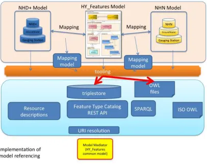
For information models to be interoperable a consistent UML style and data types are necessary. The ISO 19103 Conceptual Schema Language provides this, and the 19109 General Feature Model defines relevant Meta-classes. HY_Features, WaterML 2, and several other standards use this meta-standard. Conformance to this standard, and use of the ISO model library is necessary to generate GML and OWL using the automation tools available. Further information about the conformance to ISO standards in previous research can be found at https://www.seegrid.csiro.au/wiki/AppSchemas/WebHome
6.1.2.2 Semantic feature type catalog
information models. This is being prototyped and tested to support Testbed-10. Details can be found at https://wiki.csiro.au/display/SIRF/FeatureTypeCatalog.
The SPARQL endpoint for this is provided at: http://unsdi-dev.csiro.au/openrdf-sesame/repositories/ftc. Other API endpoints can be accessed at http://unsdi-dev.csiro.au/sissvoc/meta/.
To extend the functionality of the API, an application project should ideally provide a SPARQL CONSTRUCT query to generate a desired response, otherwise a description of the required function and its purpose. For easy visualization and display, a HTML interface to the API is required. The API could be extended to meet the specific requirements when the tools become completely available to developers through open source access in near future. The current HTML interface is enabled through a slightly hacked version of a very complex general purpose style sheet. Alternatives using Velocity are now available. Further details can be found at
https://code.google.com/p/elda/. In the Testbed-10 demonstration, these APIs were not adopted and extended, considering their developing stage. However, the concepts and the framework did help in implementing the semantic mapping with available tools and resources in the Testbed-10 project. As their APIs evolves, it is perceived that they could be directly adapted and re-used for the future implementation of semantic mapping with the common HY_Features mediation model.
6.1.2.3 HY_Features common hydrological feature model
The HY_Features model[2] is available via a Feature Type Catalog Linked Data API using a temporary domain name provided within the SIRF project in the framework of Australian Hydrological Geospatial Fabric (AU-Geofabric). The URIs for concepts defined in the OWL model are used as the basis for a URI, which may be resolved to alternative representations. The SIRF project is ongoing. Efforts are currently working to hook up all the views to all the resources.
Concepts in the HY_Features model may be accessed using the URI pattern: http://demo.sirf.net/def/schema/hydrology/{schemafilename}/{concept }
where {schemafilename} is the value of the tagged value "xsdDocument" (minus the .xsd extension) and {concept} is the name of the class or property, converted to standard conventions (UpperCamelCase? for classes, lowerCamelCase for properties).
For example, HY_Basin and outflowNode are given respectively at
http://demo.sirf.net/def/schema/hy_features/abstracthydrofeature/HY_Basin and
http://demo.sirf.net/def/schema/hy_features/abstracthydrofeature/outflowNode.
application/rdf+xml. The following is an example request that will return the OWL file containing the relevant definitions, using these same URI patterns.
https://svnserv.csiro.au/svn/SIRF/public/def/schema/hy_features/abstracthydrofeature.rdf #HY_Basin
6.1.2.4 WaterML 2 model
The WaterML-2.0 model[3], [4] could be a potential bridging model for integration of heterogeneous hydrologic data. This work is in progress. In this demonstration, the WaterML-2.0 model was not adopted and examined, considering the time constraints on implementation and existing technology of the testing implementation organizations.
6.1.2.5 RiverML model
RiverML[5], [6] is an intended standard format for river geometry and flow data by extending WaterML 2.0[3], [4] with specialization of river geometry and hydraulics. This model is still under development. It was not be used in the OWS 10 test bed.
6.1.2.6 NHD+ model
The NHD+ model is provided by the USGS model definitions .xmi, .ead, and gml schemas that are available at this link: http://www.fgdc.gov/standards/projects/incits-l1-standards-projects/framework/models/.
6.1.2.7 NHN model
Each NHN data from the ftp site (ftp://ftp.ctis.nrcan.gc.ca/pub/hydro/Denis/OWS10/) contains a corresponding descriptions file in both English and French. The description files provide metadata information about the data, including identification, data quality, spatial data organization, entity and attribute, distribution, and metadata reference.
The NHN model is divided in 4 main packages[8]–[10]:
W$R=KHG>MPHKD0A>AR=KHG>MPHKDBLF:=>NIH?G>MPHKDEBG>:K>E>F>GM:G=G>MPHKD
point element[8]. The network linear element includes network linear flow and water boundary entity. The network element represents hydro junctions.
W $R=KH@K:IAB< 0A> AR=KH@K:IAB< ?>:MNK>L BG<EN=> man made hydrogrphic entity, hydrographic obstacle entity, island, water body, simple line watercourse, and coastline[8].
W 0HIHGRFR: Toponymy is an external package that defines hydro traversal,
hydrographic entity, and named point, line, or polygon features[8].
For detailed catalogue distribution profile, further descriptions can be found on the following link[11], [12].
http://www.geobase.ca/doc/catalogue/GeoBase_NHN_Catalogue_1.0.1_EN.html
The descriptions cover feature classes, including bank, delimiter, external geometry event, external line event, eternal point event, flow property event, hydrographic obstacle entity, hydro junction, island, littoral, manmande hydrographic entity, manmade line event, manmande point event, named feature, network linear flow, obstracle line event, obstacle point event, single line watercourse, and waterbody[12].
6.2 Semantic mapping of hydrological models
The mapping between different hydrological models can be formalized through mediation by means of shared semantics. In the Testbed-10 a two-step mapping approach is applied using the HY_Features model in sense of a mediation service. At first, the hydrological models are mapped to common feature concepts of HY_Features. Secondly, the HY_Features model is “re-mapped” to the target models. Figure 2 shows the mapping approach intended to be used in this Testbed-10.
Figure 2 — Mapping framework
The semantic mapping is established through a mapping model which will allow a standard RDF/OWL encoding of data models conforming to ISO standards, particularly the emerging ISO19150-2 standard. Since each module of the HY_Features model is an ISO19109 application schema, which could be converted into RDF/OWL, the mapping to HY_Features common concepts will make NHD+ or NHN elements addressable and discoverable for automated web services following the Linked Data approach.
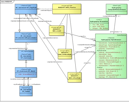
class NHD2HYF + featureCode :HydroFeatureCode [0..1] + featureType :HydroFeatureType + flowDirection :FlowCode [0..1] + geometry :Geometries
::HydroFeature
+ attribute :ExtendedAttributes [0..*] + featureDate :Date
+ featureID :Identifier
+ linkedResource :ExternalResource [0..1] + measure :Measurement [0..*] + metadata :CharacterString [0..*] + name :Name [0..*]
+ representation :Representation [0..*]
::Feature
+ attribute :ExtendedAttributes [0..*] + geometry :GM_Object [0..*] + identifier :Identifier + metadata :CharacterString [0..1] + topology :TP_Object [0..*]
«DataType» + polygon :GM_Surface
«mappingPro...
Figure 3 — NHD_Flowline - Mapping NHD_HydroElement to HY_FlowPath
Figure 3 shows the UML diagram expressing the mappings of a linear HydroElement in the NHD source model to HY_FlowPath in the HY_Features model. The following describe the three major property mappings of the mapping class:
1. NHD_InflowNode: This is the mappingProperty that maps the fromNode (relation) in NHD+ to the representedCatchment.inflowNode in HY_Features. 2. NHD_OutflowNode: This is the mappingProperty that maps the toNode (relation)
in NHD+ to the representedCatchment.outflowNode in HY_Features.
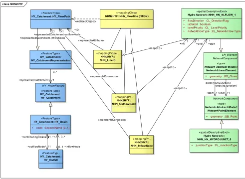
class NHN2HYF
+ flowDirection :CL_DirectionFlag + isolated :boolean
+ levelPriority :CL_ LevelPriority + networkFlowType :CL_Network Flow Type
«spatialDescriptiveEvol» Hydro Netw ork:: NHN_HN_HYDROJUNCT_0
+ junctionType :CL_JunctionType
«FeatureTyp...
+ geometry :GB_Curve
NetworkComponent
«type» Network Abstract Model::
NetworkPointElement
+ geometry :GB_Point
«mappingClass»
Figure 4 — NHN_Flowline - Mapping NHN_nlflow to HY_FlowPath
Figure 4 shows the UML diagram expressing the mappings of an nlflow feature in the NHN source models to HY_FlowPath in the HY_Features model. The following describe the three major property mappings of the mapping class:
1. NHN_InflowNode: This is the mappingProperty that maps the start node (fromJunction) relation in NHN to representedCatchment.inflowNode in HY_Features.
2. NHN_OutflowNode: This is the mappingProperty that maps the end node (toJunction) relation in NHN to representedCatchment.outflowNode in HY_Features.
6.2.1 Semantic mapping implementation in the Testbed-10
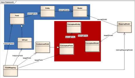
In the hydro demonstration thread of the Testbed-10, three types of semantic constructs have been implemented to support the semantic mapping among NHD+, NHN, and HY_Features, as shown in Figure 5. They are data model structure (blue shaded section in Figure 5), conceptual model structure (red shaded section in Figure 5), and mapping model structure.
1. Data model structures: The data model structure includes elements for model, entity, and field. Here, model is used to define data model, like NHN and NHD+. Entity is used to define the entity or table belong to a model, like nlflow in NHN. The relation “belongModel” can be used to connect Model and Entity. Field is used to define the field or attribute of an entity, like to_junct in nlflow. The relation “belongEntity” can be used to connect Entity and Field. IDField is a Field, which is used to uniquely represent an identifier of an Entity.
2. Conceptual model structures: The conceptual model structure has ConceptualModel, ConceptualEntity, and ConceptualField. They are similar in definition as those for the data model structure, but they are used as an intermediate data structures to bridge the source model structure and the target model structure. In this project, the HY_Features model is used as the basis for constructing these conceptual model structures.
3. Mapping model structures: The mapping model structure has three classes, FieldMapping, MappingModel, and CustomizaField. The basic mapping approach is Field to Field mapping under this framework. Mapping relationships are described by properties, i.e. mappingField, targetField, sourceModel, and targetModel, to represent source field, target field, source model, and target model respectively. Under this framework, the class FieldMapping can use the property mappingField to connect with the Field, which is a class of the data model. The class FieldMapping can also use property targetField to connect with the ConceptualField, which is a class of the conceptual model structure.
Figure 5 — Semantic Mapping Framework
6.2.2 NHD+ / NHN source models and HY_Features
The HY_Features model is used as the conceptual model structure under the mapping framework. Figure 6 shows the conceptual model relationship. The model has an entity HY_FlowPath and a field HY_FlowPath_ID.
object hy_feature
hy_feature : ConcepualModel
HY_FlowPath : ConcepualEntity
HY_FlowPath_ID : ConcepualField
Figure 6 — Conceptual Model Structure: HY_Features
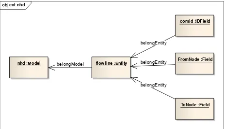
oect nhd
nhd :odel flow line ntity
FromNode :Field comid :IDField
ToNode :Field
belongEntity belongEntity belongEntity
belongModel
Figure 7 —Data Model Structure: NHD+
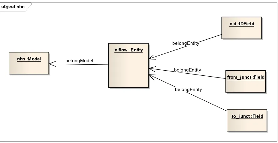
ect nhn
nhn :odel
nid :IDField
nlflow ntity
from_unct :Field
to_unct :Field
belongEntity
belongModel
belongEntity
belongEntity
Figure 8 — Data Model Structure: NHN
6.3 Mediation system implementation
6.3.1 Overall system architecutre
Hydro Model
Figure 10 — Interactions between component services
6.3.2 Service components
6.3.2.1 Hydro model mediator
The hydro model mediator consists of Web services and components that interact with different hydro data models and response to requests from clients through the hydro model service. The current implementation leverages the existing Web services and databases to interact with back end data services. The backend data can exist in database, data store, and semantic data store (e.g. RDF data store, OWL data store). Their access may be enabled through traditional SQL database query, SPAQRL query, GeoSPARQL query, or WFS requests. As shown in Figure 9, the results could be stored persistently through transaction capability of OGC WFS and made available to clients if persistent storage is desired. Alternatively, the result can be directly sent back to client, especially when the process can be done synchronously within a short period of processing time.
6.3.2.2 Hydro model service
6.3.3 Backend communication between service components
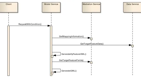
Figure 11 illustrates the communications between Model Mediator and Hydro Model Service at server side.
Figure 11 — Service Communication
This instance was assumed that initial POI located at RedRiver? of Canadian side.
1. Client sends a request with two parameters to model service, includes the POI(lat, lon) and data model that the user expects to get eventually.
3. Model service applies JUNCTION relationship(fields of NLFLOW attribute, matched juntion ID in both NLFLOW, isolated = 0) to find upstream NLFLOW features.
4. After all upstream NLFLOW has been processed out, Model Service will send junction fields to Mediation Service to get mapping field, class, feature in NHD.
5. Mediation Service uses HY_FEATURE to find the mapped fields of NHD 6. Mediation Service returns the NHD fields to model service.
7. Model service uses the location of upstream junction that nearest border as initial POI, and search all upstream watershed of the US side.
8. After Model service get entire upstream watershed from both sides, it sends a request to Mediation service with all fields and the target model.
9. Mediation service returns the mapping rules(not sure the implementation approach yet) 10. Model service re-generates the feature based on the mapping rules, and save as GML format with target data model.
6.3.4 Mapping implementation using xlink
Initially, xlink was used to quickly implement the relationships between classes of the HY_Features model. The reasons for adopting xlink are its ease of use, straightforwardness, and previous experiences of implementation team. A simple example is given below to illustrate the idea of using xlink in enabling the classes of the HY_Features model and their mapping to/from other models.
Using xlink to represent the relation between classess of the HY_Features model: The
association [representedCatchment] of HY_FlowPath links to a HY_Basin, here, basin2. The association can be expressed as follows.
<HY_FlowPath>
<representedCatchment xlink:href="#basin2"/> </HY_FlowPath>
<HY_Basin id="basin2" >
<inflowNode xlink:href="#outflow1"/> <outflowNode xlink:href="#outflow2"/> </HY_Basin>
Using xlink to link objects among HY_Features, NHN, and NHD+: The following
<HY_Basin id="basin1"
xlink:href="http://geobase.ca/geobase/nhn/nhn_hn_nlflow#d30e64b950f04319b"> <outflowNode xlink:href="#outflow1"/>
</HY_Basin>
Therefore, xlink can be used to establish a XML that links the real data model and the HY_Feature reference model. The Hydro Model Service can get the data through resolving this XML. The following is a complete HY_Features relationship in XML.
<HY_Features xmlns:xlink="http://www.w3.org/1999/xlink"> <HY_FlowPath xlink:href="http://nhn/nlflow#2b1b3456762d"> <representedCatchment xlink:href="#basin1"/>
<id xlink:href="http://nhn/nlflow/nid"/>
<fromnode xlink:href="http://nhn/nlflow/from_junction"/> <tonode xlink:href="http://nhn/nlflow/to_junction"/> </HY_FlowPath>
<HY_FlowPath xlink:href="http://nhd/FlowlineVAA#2b1b9b62d"> <representedCatchment xlink:href="#basin2"/>
<id xlink:href="http://nhd/FlowlineVAA/ComId"/>
<fromnode xlink:href="http://nhd/FlowlineVAA/FromNode"/> <tonode xlink:href="http://nhd/FlowlineVAA/ToNode"/> </HY_FlowPath>
<HY_Basin id="basin1" xlink:href="http://nhn/waterbody#2b1b3456762d"> <outflowNode xlink:href="#outflow1"/>
</HY_Basin>
<HY_Basin id="basin2" xlink:href=" http://nhd/waterbody#2b1b9b62d"> <inflowNode xlink:href="#outflow2"/>
<outflowNode xlink:href="#outflow3"/> </HY_Basin>
<HY_Outfall id="outflow1" xlink:href="http://nhn/#aa9729ee053"> <contributingBasin xlink="#basin1"/>
<receivingBasin xlink="#basin2"/> </HY_Outfall>
<HY_Outfall id="outflow2" xlink:href="http://nhd#1e7f53d2b29"> <contributingBasin xlink="#basin2"/>
<receivingBasin xlink="#basin3"/> </HY_Outfall>
<HY_Outfall id="outflow3"
xlink:href="http://geobase.ca/geobase/nhn/nhn_hn_hydrojunct#4ed6574fc6fc"> <contributingBasin xlink="#basin3"/>
A flow line has been described with different class names, attributes and fields in NHN and NHD/NHD+ source models. In this pilot implementation, HY_Flowpath, a predefined class in HY_Features, was used to represent flow lines using the HY_Features model as a reference model. Attributes, fromNode and toNode, were created for mapping from_Junction/to_Junction in NHN and fromNode/toNode in NHD. Figure 12 shows exemplarily the mapping of nlflow in NHN, flowline in NHD, and PlusFlowline in NHD+ to HY_FlowPath in HY_Features.
Figure 12 — Flow line mapping using Xlink
6.3.5 Semantic mapping implementation and example queries
The semantic mapping was implemented as a prototype OWL-based knowledgebase. The
http://59.120.223.164:443/hy_feature_mapping/query (last accessed 7/16/2014). It is a standard SPARQL endpoint.
Using the SPARQL engine, we can query different matching models, entities, and fields. In the following example, we focus on flowpath in terms of HY_Features. Table 2 shows the query to find out what entities available in HY_Features model. Figure 13 shows the results returned from the prototype SPARQL engine.
Table 2. An example query to find the entities in HY_Features
prefix mapf: <http://modelmapping/framework#> SELECT distinct ?entity
WHERE {
?entity mapf:belongModel <http://hy_feature> }
Figure 13. Result of the query in Table 2
The fields supported by the entity HY_FlowPath can be further found out through the query shown in Table 3. Figure 14 shows the fields returned from the prototype SPARQL engine.
Table 3. An example query to find the fields of HY_FlowPath in HY_Features model
prefix mapf: <http://modelmapping/framework#> prefix hyf: <http://hy_feature#>
SELECT distinct ?hy_field WHERE {
?hy_field mapf:belongEntity hyf:HY_FlowPath. }
Semantic mapping models for the entity can be found using the query shown in Table 4. Figure 15 shows the models that can be mapped to by the HY_FlowPath in HY_Features model. The SPARQL engine returns two matching models – NHD+ and NHN.
Table 4. An example query to find the models to be mapped from HY_FlowPath in HY_Features model
SELECT distinct ?model WHERE {
?hy_field mapf:belongEntity hyf:HY_FlowPath. ?mapping mapf:targetField ?hy_field.
?mapping mapf:belongMappingModel ?mappingModel. ?mappingModel mapf:sourceModel ?model.
}
Figure 15. Result of the query in Table 4
6.4 Use cases
6.4.1 Use case 1: Mapping hydrographic features from NHD+ to HY_Features
6.4.1.1 Description
The first use case is raised when user wants to convert a hydrographic feature in NHD+ database to a common feature in HY_Features. The following describes the general sequence of this use case.
1. Select a watershed or an area of interest (AOI) that lies in US where original data are stored and managed in NHD+ database or feature store.
2. The request of hydrographic features is sent to Hydro Model Service. The Hydro Model Service contact the NHD+ feature data store to retrieve the hydrographic features falling within AOI in original NHD+ model format.
4. The Hydro Model Service returns resulted feature collection in HY_Features to client in HY_Features model. The results can be direct feature stream or a feature collection stored and managed by a persistent feature data store such as WFS. 5. Provenance or lineage metadata is available to relate the identity of features in
source models to HY_Features types.
ecta nHD
HY_Flowath_InFlow Node :
CustomizedField
HY_Flowath_OutFlow Node :
CustomizedField
Figure 16 — Use case 1: mapping flow line from NHD+ to HY_Features
6.4.1.2 Demonstration
Demonstration endpoint: http://59.120.223.164/hydro/ (last accessed 7/16/2014). Figure 17 and Figure 18 show the two major steps to use Hydro Model Service and Hydro Mediation Service to map hydrographic features in NHD+ to those in HY_Features. As shown in Figure 17, an AOI covering between 97.237ºW, 48.984ºN, and 97.220ºW, 48.992ºN. The AOI lies in US. It covers a small area across Red River between North Dakota and Minnesota, close to the border of Canada.
Figure 18 — Use case 1 step 2: Retrieve results in HY_Features
Semantically, the match model can be queried through the SPARQL engine described in Section 6.3.5. Table 5 shows the example query to find the mapping models, entities and fields between HY_FlowPath in HY_Features to those in NHD+. Figure 19 the results returned from the SPARQL engine given in Section 6.3.5.
Table 5. An example query to find the mapping of HY_FlowPath to NHD+
SELECT distinct ?hy_field ?entity ?source_field WHERE {
?mapping rdf:type mapf:FieldMapping. ?mapping mapf:targetField ?hy_field.
?mapping mapf:mappingField ?source_field. ?hy_field mapf:belongEntity hyf:HY_FlowPath. ?source_field mapf:belongEntity ?entity.
?entity mapf:belongModel <http://nhd>. }
6.4.2 Use case 2: Mapping hydrographic features from NHN to HY_Features
6.4.2.1 Description
The first use case is raised when user wants to convert a hydrographic feature in NHN database to common feature in HY_Features. The following describes the general sequence of this use case.
1. Select a watershed or an area of interest (AOI) that lies in Canada where original data are stored and managed in NHN database or feature store.
2. The request of hydrographic features is sent to Hydro Model Service. The Hydro Model Service contacts the NHN feature data store to retrieve the hydrographic features falling within AOI in original NHN model format.
3. The Hydro Model Service interacts with Hydro Mediation Service to semantically map hydrographical features in NHN to the counterparts in HY_Features.
4. The Hydro Model Service returns resulted feature collection in HY_Features to client in HY_Features model. The results can be direct feature stream or a feature collection stored and managed by a persistent feature data store such as WFS. 5. Provenance or lineage metadata is available to relate the identity of features in
source models to HY_Features types.
!"#ect$a%%& ')*HN
HY_Flow+ath :
Conce%,ual-ntity
.from/0_f123 45e)
HY_Flow+ath_InFlow Node :
Customi6edField
HY_Flow+ath_OutFlow Node :
Customi6edField
ma%%&'):nlflow _from_#unct :
Fiel;$a%% & ')
Figure 20 — Use case 2: Mapping flow line from NHN to HY_Features
6.4.2.2 Demonstration
Demonstration endpoint: http://59.120.223.164/hydro/ (last accessed 7/16/2014). Figure 21 and Figure 22 show the two major steps to use Hydro Model Service and Hydro Mediation Service to map hydrographic features in NHN to those in HY_Features. As shown in Figure 21, an AOI covering between 97.363ºW, 49.332ºN, and 97.300ºW, 49.366ºN. The AOI lies in Canada. It covers a small area across Red River in Manitoba, Canada.
Figure 22 — Use case 2 step 2: Retrieve results in HY_Features
Similar to the semantic matching for conversion from NHD+ to HY_Features, the match model can also be queried through the SPARQL engine described in Section 6.3.5. Table 6 shows the example query to find the mapping models, entities and fields between HY_FlowPath in HY_Features to those in NHN. Figure 23 the results returned from the SPARQL engine given in Section 6.3.5.
Table 6. An example query to find the mapping of HY_FlowPath to NHN
SELECT distinct ?hy_field ?entity ?source_field WHERE {
?mapping rdf:type mapf:FieldMapping. ?mapping mapf:targetField ?hy_field.
?mapping mapf:mappingField ?source_field. ?hy_field mapf:belongEntity hyf:HY_FlowPath. ?source_field mapf:belongEntity ?entity.
6.4.3 Use case 3: Hydrographic mapping between NHD+ and NHN
6.4.3.1 Description
This use case applies to clients who want to map one format or hydro model to another using HY_Features model as the mediation model. In this demonstration implementation setting, there are two cases corresponding to the use of mapping functions demonstrated in Use Case 1 in Section 6.4.1 and Use Case 2 in Section 6.4.2. Here are the details for two sub-cases:
1. Use Sub-Case 1: First, we apply Use Case 1 (See Section 6.4.1) to map hydrographic features in NHD+ model to those in HY_Features model. Second, we apply Use Case 2 (Refer to Section 6.4.2) in reverse mapping direction to map the features in HY_Features to those in NHN model. Figure 24 shows the complete sequence of interactions. The results are presented to clients in NHN model.
sd UC1: NHD for NHN client
Client - create transboundary rivermap
DataService: NHD+ / NHN
HydroModelService
WFS. MediationService:
HY_Features
Display flowlines from NHD data for NHN client
NHN select AOI in US()
get NHD flowline()
get NHD flowline, accessbile for NHN()
get reference concept()
reference concept: HY_Flowpath()
get HY_Flowpath equivalent from NHD()
NHD: hydroElement_line()
execute map NHD to HY_Flowpath()
execute map NHN to HY_Flowpath()
execute export to NHN() NHD flowline accessible for NHN()
display NHD flowline()
sd UC2< U=>: NHN for NHD client
Display flowlines from NHN data for NHD client
NHD select AOI in CA()
get NHN flowline()
get NHN flowline, accessbile for NHD()
get reference concept()
reference concept: HY_Flowpath()
get HY_Flowpath equivalent from NHN()
NHN: nlflow()
execute map NHD to HY_Flowpath()
execute map NHN to HY_Flowpath()
execute export to NHD() NHN flowline accessible for NHD()
display NHN flowline ()
Figure 25 — Sequence graph of Use Case 3.2: Map NHD+ to NHN
6.4.3.2 Demonstration
Figure 26 — Use Case 3.1 demo: Results in NHD+
6.4.4 Use case 4: Finding upstream service
6.4.4.1 Description
The use case represents the situation when a user wants to find all the hydrographic features following an upstream tracing. Figure 27 shows the typical sequence of finding upstream service. The following describe the general sequence briefly.
1. The user chooses a point, either in US or in Canada and submits a request to the Hydro Model Service. To simplify description, we assume that we choose one point in Canada as the first starting point. We also decide to retrieve the results in NHN model. (Note: In the following steps, we will take some assumption to walk through one logic branch while ignoring another fork, to shorten the description. In all cases, the walkthrough for another fork works similarly.)
3. Of the two receiving data stores – NHD+ and NHN, at the starting point, only does the NHN data store send back hydrographic features. The Hydro Model Service adds it to the feature collection to be returned.
4. The Hydro Model Service determines the upstream endpoint of the found hydrographic features and broadcasts search request for the endpoints to all data stores again.
5. All data stores return the hydro features connecting to the endpoints. If the feature is returned from NHN data store in NHN model, the Hydro Model Service adds it to the feature collection to be returned.
6. If the feature is returned from NHD+ data store in NHD+ model, the Hydro Model Service sends the feature in NHD+ model to the Hydro Mediation Service for mapping it to feature in NHN model. The Hydro Model Service adds the converted feature in NHN model to the feature collection to be returned.
7. The Hydro Model Service repeats step 4-6 until there is no more connecting hydro feature found along the upstream trace.
8. The Hydro Model Service returns the results in NHN model. The above sequence can have the following variations:
(1) The user chooses a point in Canada and decides to get results in NHN model (This is what the above sequence describes.)
(2) The user chooses a point in US and decides to get results in NHN model.
(3) The user chooses a point in Canada and decides to get results in HY_Features model.
(4) The user chooses a point in US and decides to get results in HY_Features model. (5) The user chooses a point in Canada and decides to get results in NHD+ model. (6) The user chooses a point in US and decides to get results in NHD+ model.
sd UCAB Find uCstream service
display flowlines from NHN for NHD upstream of POI
NHD selectDOI in US()
get NHN flowlines upstream ofDOI()
get NHN flowline upstream ofDOI, accessbile for NHD()
get reference concept()
reference concept: HY_Flowpath()
get HY_Flowpath equivalent from NHN()
NHN: nlflow()
execute find toNode closest toDOI()
get nlflow from NHN()
NHN: nlflow()
execute map NHN to HY_Flowpath()
execute export to NHD() upstream NHN flowline accessible for NHD()
display NHN flowline upstream ofDOI ()
Figure 27 — Use case 4: Finding upstream service
6.4.4.2 Demonstration
Demonstration endpoint: http://59.120.223.164/hydro/ (last accessed 7/16/2014). In this demonstration, the user chooses a start point at 97.189ºW, 49.038ºN, a point located in Ginew, Manitoba R0A 2R0, Canada. Figure 28 shows the starting point, the initial request and response from Hydro Mediation Service. The following brief the major steps.
2. The first several found sections of Joe River are features in NHN model, in Canada.
3. At the border between US and Canada, the connected upstream of Joe River is found and search continues. The Hydro Model Service interacts with the Hydro Mediation Service map found features in NHD+ model in US to corresponding features in NHN model.
4. The search end at the upstream source of Joe River in Minnesota, US. The complete feature collection in NHN model is returned to the user by the Hydro Model Service. Figure 29 shows the found feature collection of Joe Rive, covering both sections in Manitoba, Canada and Minnesota, US.
Figure 29 — Use case 4 demo: Result feature collection in NHN model
6.4.5 Use case 5: Heterogeneous hydrological model integration mapping (NHN/NHD+)
6.4.5.1 Description
Use case 5 is the integrated mapping of heterogeneous hydrographic models into one target hydrographic model. Figure 30 shows one typical sequence of converting features under heterogeneous hydro models into one target hydro model. The following describe the general sequence.
2. The Hydro Model Service receives the request from the user. It broadcasts the search for hydrographic features intersected with the AOI to all data stores, including NHD+ data store and NHN data store.
3. The Hydro Model Service retrieves all hydrographic features intersected with the AOI from NHD+ data store in NHD+ model. The returned features in NHD+ model are sent to the Hydro Mediation Service to be mapped into features in HY_Features. It adds all the returned features in HY_Features model into the intermediate feature collection in HY_Features model.
4. The Hydro Model Service retrieves all hydrographic features intersected with the AOI from NHN data store in NHN model. The returned features in NHN model are sent to the Hydro Mediation Service to be mapped into features in HY_Features. It merges all the returned features in HY_Features model into the intermediate feature collection in HY_Features model.
5. The merged features in HY_Features model are then sent to the Hydro Mediation Service to be mapped to NHD+ model. The mapped feature collection is returned to the Hydro Model Service.
6. The Hydro Model Service returns all the merged and converted feature collection in NHD+ model that the AOI intersects with.
The above sequence can have the following variations:
(1) The user chooses an AOI across borders of Canada and US. The user decides to require result hydro features in NHD+ model (This is what the above sequence describes.)
(2) The user chooses an AOI across borders of Canada and US. The user decides to require result hydro features in NHN model
(3) The user chooses an AOI across borders of Canada and US. The user decides to require result hydro features in HY_Features model.
Figure 30 — Use Case 5: Hydrographic Mapping of Heterogeneous Hydro Models
There was one problem rised for crossing model data integration. There is data displacement due to scale and other resolution. The endpoint of a flow path may not exactly match that of the corresponding path. To enable the continous connection of flow paths, the project adopted what the sponsor suggested to establish a framework to allow manual definitioin of relationships along borders. Figure 31 shows the overall framework to set the equivalent models between two models. Figure 32 shows how to establhis the equivalent relationship between NHD+ and NHN models.
the framework used in the demonstration. A class CrossModelData is used to define the equivalence. In semantical representations, four property predicates are defined to capture the equivalence relationhip: crossModel relates a CrossModelData to Model, crossField to the field of the model, dataField to information field, and dataEquivalent to associations of two CrossModelData instances.
class cross_model_framew ork
Field
Entity
Fodel
CrossFodelData
dataField
dataEquivalent
crossField crossGodel
belongEntity
HIJectKaLLNngCrossKodel
maL Nng_node_NHD :
Field
Demonstration endpoint: http://59.120.223.164/hydro/ (last accessed 7/16/2014). In this demonstration, the user an AOI with bounding box 97.683ºW, 48.778ºN, and 96.639ºW, 49.182ºN. The AOI crosses the border between US and Canada, covering partial Cavalier, North Dakota 58220, US and Niverville, Manitoba R0A, Canada. Figure 33 shows the AOI and initial interactions between the Hydro Model Service and the Hydro Mediation Service. This demonstration matches the sequence described in Section 6.4.5.1. The following brief the major steps and their intermediate results.
2. The Hydro Model Service interacts with the Hydro Mediation Service to map linear features from both NHD+ model and NHN model to HY_Features model. All features are merged into a flow line feature collection in HY_Features model as shown in Figure 34.
3. The Hydro Model Service interacts with the Hydro Mediatiion Service to map the merged flow line feature collection in HY_Features to the target NHD+ model. Figure 35 shows the returned, merged feature collection in NHD+ model.
Internally, the semantic SPARQL engine was used to query the possible models to connect the equivalent nodes. Table 7 lists one example query to look for cross model data euqivalent. Figure 36 shows the result returned from the SPARQL engine described in 6.3.5. In this example, according to the result, we can use the value of to_junct to search the data in the field [mapping_node_NHN] of the entity [mapping_node], and get the value from the field [mapping_node_NHD] which contains the value to be converted to in NHD model.
Table 7. An example query to match cross-model data
SELECT distinct ?entity ?sourceField ?targetField WHERE {
?cross mapf:crossField nlflow:to_junct. {
{?cross mapf:dataEquivalent ?t} union
{?cross ^mapf:dataEquivalent ?t} }
?cross mapf:dataField ?sourceField. ?t mapf:dataField ?targetField.
?sourceField mapf:belongEntity ?entity }
Figure 36. Result of the query in Table 7
7 Best Practices
7.1 Access hydrologic from multiple data sources