Syarbaini / Atom Indonesia Vol. 41 No. 1 (2015) 41 - 45
Terrestrial Gamma Radiation Exposure in
Bangka-Belitung Islands, Indonesia
Syarbaini
*and A. Setiawan
Center for Technology of Radiation Safety and Metrology, National Nuclear Energy Agency, Jl. Lebak Bulus Raya No.49, Jakarta 12440, Indonesia
A R T I C L E I N F O A B S T R A C T
Article history:
Received 27 August 2014
Received in revised form 05 March 2015 Accepted 30 March 2015
Keywords:
Natural radionuclides Terrestrial gamma radiation In situ measurements Bangka Belitung
Bangka-Belitung is known as tin producer and it geologically contains higher concentrations of natural radionuclides than most other areas. The aim of this study was to evaluate the level of terrestrial gamma radiation in Bangka-Belitung Islands. The external gamma radiation dose rate from terrestrial gamma-rays have been measured at one meter above the ground by means of a portable gamma spectrometer at 66 survey points. The terrestrial gamma dose rates in Bangka island range from 43.67 to 511.54 nGy h-1 with a mean of 183.45 nGy h-1, while in Belitung island they range from 15.54 to 416.39 nGy h-1 with a mean of 132.60 nGy h-1. From this work, a strong correlation was found between dose rates found from in-situ radiation measurements and dose rates calculated theoretically from radioactivity contents of the soil at the same locations. Generally, Bangka-Belitung islands have higher outdoor natural gamma dose rates than the world average value of 0.058 μGy h-1 for the regions with normal background radiation specified by United Nations Scientific Committee on the Effects of Atomic Radiation (UNSCEAR).
© 2015 Atom Indonesia. All rights reserved
INTRODUCTION
Terrestrial gamma radiation comes from two sources, namely terrestrial sources from radionuclides and extraterrestrial sources in the form of cosmic radiation. The terrestrial radionuclides include decay chain radionuclides, such as uranium-238 (238U) and thorium- 232 (232Th), and non-decay chain radionuclides, such as potassium-40 (40K), which have been present in the earth (in rocks and soils) since its formation. The activity concentrations of these radionuclides in the soil and in the surrounding environment, as well as the associated external exposure due to the gamma radiation, depend primarily on the geological and geographical conditions of the region [1].
The Bangka-Belitung islands are known as a tin-producing area which forms a part of the Southeast Asian Tin Belt, the richest tin belt in the world which spans from South China - Thailand - Myanmar - Malaysia to Indonesia. Tin is the
Corresponding author.
E-mail address: sarbaini@batan.go.id
essential mineral resource of the Bangka-Belitung islands, with accessory minerals consisting of monazite, zircon, xenotime, ilmenite, magnetite and pyrite. Tin deposits are found as primary and secondary deposits [2].
Tin mining and processing of by-product-heavy minerals from tin mining as contributed a number of natural radionuclides to the environment; this contribution occurs since those minerals, such as heavy mineral sand, monazite, ilmenite, zircon or xenotime, contain natural radioactive elements which co-exist with the tin ore or cassiterite in the ground [3-6].
The activity concentrations of natural radionuclides in soil of Bangka and Belitung islands have been previously reported [7]. Generally, the average and ranges of activity concentrations of radionuclides in soil collected from Bangka and Belitung islands are higher than the common areas world average, except for 40K. The activity
concentrations of 226Ra, 232Th and 40K are in the 4.8 - 544 Bq kg-1, 7.3 - 2170 Bq kg-1, and 5.3 - 368
Bq kg-1ranges with mean values of 72.3, 203 and
Atom Indonesia
70.0 Bq kg-1, respectively. World averages for226Ra,
232
Th and 40K are 35 Bq kg-1, 30 Bq kg-1 and 400 Bq kg-1 respectively. The previous study was also carried out to evaluate the natural radioactivity concentration in some food crops grown in Bangka and Belitung Islands. There was an indication that the mining activities in Bangka-Belitung islands impacted the radiation burden of the environment [8].
The activity of tin dressing and refining during the past years which spread over the Bangka-Belitung areas may cause the enhancement of the environmental dose rate due to natural radionuclides. In this study, the distribution of outdoor gamma dose rates from terrestrial gamma radiation in Bangka-Belitung islands and their effective dose rates were investigated.
EXPERIMENTAL METHODS
Site descriptions
Geographically, Bangka - Belitung Islands are
located at 104° 50’ - 109° 30’ E and 0° 50’ - 4° 10’
S. The total area of Bangka-Belitung Islands is about 81,725.14 km2, consisting of a land area of about 16,424.14 km2 or 20.1 percent of the total area and a sea area of about 65,301 km2 or 79.9 percent of the total area. The Bangka Strait separates Sumatera Island from Bangka Island whereas the Gaspar Strait separates Bangka Island from Belitung Island. North of the islands liesthe South China Sea, to the south lies the Jawa Sea, and Kalimantan Island lies in the east, separated from Belitung Island by the Karimata Strait.
In general, the topography of Bangka-Belitung is relatively flat, mostly ranging from lowlands to hilly lands, with only a small part of the islands being mountainous. The altitude of the
lowland is around 50 m above the sea level. The highest point in the Bangka Island is in the
pinnacle of Maras Mountain at an altitude of 699 meter, while in Belitung Island it is in the Tajam
Mountain with an altitude of 500 m above the sea level [9].
Measurement points
The sampling points were selected by dividing each of the total area of the Bangka and Belitung islands using a square grid as reported previously [7]. Geographical coordinates of sampling points were determined using a 60CHx global positioning system (GPS) map manufactured
Gamma dose rate
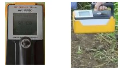
The gamma dose rate was measured at one meter above the ground by means of a portable gamma spectrometer (Model GR-130 Mini Spec, produced by Exploranium Company, Canada). The instrument was calibrated by a secondary standard dosimetry laboratory under the National Nuclear Energy Agency of Indonesia. For statistical purposes, 10 readings were taken at each point of reading and the average was recorded. Further, some environmental parameters such as temperature, pressure, relative humidity and weather conditions at the time of measurement were recorded.
Fig. 1. MiniSpec Exploranium GR 130.
RESULTS AND DISCUSSION
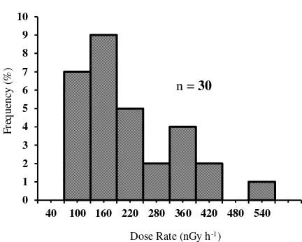
The terrestrial gamma dose rate measurements at one meter above surface soil in Bangka and Belitung islands were found to be varying in different sites. The terrestrial gamma dose rate of Bangka Island ranged from 43.67 to 511.54 nGy h-1 with a mean of 183.45 nGy h-1, while for Belitung island it ranged from15.54 to 416.39 nGy h-1 with a means of 132.60 nGy h-1.
Additionally, the increasing tin mining activities by individuals and illegal mines in Bangka-Belitung islands may also be responsible for the enhanced radioactivity in the area. Generally,
tin mining leaves some natural radionuclides which easily transfers from the mining location to
its surrounding environment which goes up to the land surface [10-12].
All surveyed areas (Bangka-Belitung) showed considerably higher ambient gamma dose rates, compared with the global outdoor natural gamma
dose rate average of 0.058 μGy h-1
[13]. It may be caused by the possible rise in concentration due to the accumulation of mineral sands from various mining activities in Bangka-Belitung
islands. The soil in Bangka-Belitung is severely
Fig. 2. Frequency histogram of dose rate in Bangka
Fig. 3. Frequency histogram of dose rate in Belitung
The results of direct measurements present work have been previously reported [7].
The outdoor air-absorbed dose rates due to terrestrial gamma rays at 1 m above the ground level have been calculated from 226Ra, 232Th and 40K Carlo simulations using mathematical phantoms
[1,19].
Figures 4 and 5 show the correlations found between dose rates obtained from in-situ radiation measurements and dose rates theoretically calculated from radioactive
contents of soils at the same locations. As can be seen in Figs. 4 and 5, the relationship
between dose rates calculated from concentrations
of 226Ra, 232Th and 40K in soil samples of Bangka-Belitung and dose rates obtained using a MiniSpec Exploranium GR 130 gamma ray
spectrometer at the same sites showed high correlation coefficients (r = 0.8526 and
0.8883). A reasonable relationship can be seen.
Plots of the two variables (x = theoretical, y = experimental) used in the study showed that they were linearly related. The intercept
Fig. 4. Relationship between directly measured dose rates and dose rates calculated from concentration of 226Ra, 232Th and 40K in soil samples from Bangka.
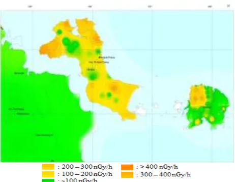
Fig. 5. Relationship between directly measured dose rates and dose rates calculated from concentration of 226Ra, 232Th and 40K in soil samples from Belitung terrestrial gamma absorbed dose rates measured in
various places in the Bangka-Belitung islands. It can be seen from Fig. 6 that the higher gamma dose rates are found in the region of Bangka island and in the western part of Belitung island. It may be influenced by many
factor such as the differences in soil characteristics, geological conditions of the island, and mining adjacent regions. This variation is associated with the distribution of radionuclide activity concentrations of the soil. It has been observed that there was a good correlation between direct measured dose rates and calculated terrestrial dose rates in all sites. Generally, the average and ranges of the terrestrial gamma dose rate the whole Bangka and Belitung islands are higher than the world average.
ACKNOWLEDGMENT
The author would like to thank Mr. Kusdiana, Staff of the Radioecology Division, Center for Technology of Radiation Safety and Metrology,
National Nuclear Energy Agency, Indonesia for his support in preparing the contour map in this study. The author also gratefully
acknowledges all staff of the Environmental Safety group, Radioecology Division, for their technical assistance.
REFERENCES
1.
Anonymous,
Exposures from Natural
Radiation Sources
, in: Sources and Effects
of Ionizing Radiation, United Nations
Scientific Committee on the Effects of
Atomic Radiation (UNSCEAR) Report,
Vol.
I,
Annex
B,
United
Nations
Calculated gamma dose rate (nGy h-1)
y = 0.6927x + 43.332
2. M. O. Schwartz, S. S. Rajah, A. K. Askury,
et al., Earth-Science Reviews 38 (1995) 95.
3. A.M. Arogunjo, V. Hollriegl, A. Giussani,
et al., J. Environ. Radioact. 100 (2009) 232.
4. I.G.E. Ibeanu, J. Environ. Radioact. 64
(2003) 59.
5. N.N. Jibiri, I.P. Farai and S.K. Alausa, J. Environ. Radioact. 94 (2007) 331.
6. I. Bahari, N. Mohsen and P. Abdullah, J. Environ. Radioact. 95 (2007) 61.
7. Syarbaini, Kusdiana and D. Iskandar, International Journal of Sustainable Energy and Environment 3 (2015) 1.
8. Syarbaini, A. Warsona and D. Iskandar, Atom Indonesia 40 (2014) 27.
9.
Anonymous, Climate and Topography
http://www.babelprov.go.id/content/iklim-dan-topografi, Retrived in April 2015.
10. A.M. Arogunjo, V. Hollriegl, A. Giussani,
et al., J. Environ. Radioact. 100 (2009) 232.
11. A.J. Innocent, M.Y. Onimisi and S.A. Jonah, British Journal of Applied Science and Technology 3 (2013) 684.
12. I.R. Ajayi, Iran J. Radiat. Res. 5 (2008) 203.
13. Anonymous, Exposures from Natural Sources
of Radiation, in: Sources, Effects and Risks of
Ionizing Radiation, United Nations Scientific Committee on the Effects of Atomic Radiation (UNSCEAR) Report, Annex A, United Nations publication, New York (1988) 57
14. M. Sidabukke, Illegal Tin Minning at Protection Forest Area (Case Study at Protection Forest Area of Sepang Mountain, Badau, Bangka Belitung), Ph.D. Thesis, University of Indonesia (2011).
15. Anonymous, Exposures from Natural Sources
of Radiation, in: Sources and Effects of
Ionizing Radiation, United Nations Scientific Committee on the Effects of Atomic Radiation (UNSCEAR) Report, Annex A, United Nations publication, New York (1993) 65.
16. D.C. Kocher and A.L. Sjoreen, Health Phys. 48
(1985) 193.
17. S. Singh, A. Rani and R.K. Mahajan, Radiation Measurements 39 (2005) 431.
18. H.A. Al-Sulaiti, Determination of Natural Radioactivity Levels in the State of Qatar Using High-Resolution Gamma-ray Spectrometry, Ph.D. Thesis, Surrey University (2011).
19. Anonymous, Exposure to Natural Radiation
Sources, in: Ionizing Radiation Sources and
Biological Effects, United Nations Scientific Committee on the Effects of Atomic Radiation (USNCEAR) Report, Annex B, United Nations publication, New York (1982) 87.
20. M.A. Saleh, A.T. Ramli, Y. Alajerami, et al., J. Environ. Radioact. 124 (2013) 130.
21. K. Chikasawa, T. Ishii and H. Sugiyama, J. Health Science 47 (2001) 362.