National Strategy and Action Plan
for Sustainable Management
of Peatlands
FINAL DRAFT
(AUGUST 2006)
NATIONAL STRATEGY AND ACTION PLAN
FOR SUSTAINABLE MANAGEMENT OF PEATLANDS
© Departemen Dalam Negeri, 2006
Writing Team: A. Patrons
1. H. Syamsul Arief Rivai Dirjen Bina Bangda, Depdagri Advisor 2. Dra. Masnellyarti Hilman, M.Sc. Deputi Bidang Peningkatan Konservasi Advisor
SDA dan Pengendalian Kerusakan
Lingkungan, KLH
3. Ir. M. Arman Mallolongan, MM Dirjen PHKA, Departemen Kehutanan Advisor 4. DR. Ichwanuddin Mawardi Sahmen PPN Bidang Percepatan Advisor
Pembangunan Kawasan Timur Indonesia dan Kawasan Tertinggal B. Working Group
1. Prof. DR. Tjahya Supriatna, SU Ditjen Bina Bangda, Depdagri Coordinator
2. DR. Agus Prabowo Bappenas Member
3. Drs. Bambang Jasminto, M.Sc. Dit. Anggaran IIDitjen APK, Depkeu Member 4. Ir. Antung Deddy Radiansyah Kementrian Lingkungan Hidup Member 5. Ir. Bambang Sukmananto, M.Sc. Ditjen PHKA, Dephut Member 6. Drs. Dibjo Sartono Wetlands International – IP Member 7. Ir. Listya Kusumawardani, M.Sc. Ditjen BPK, Dephut Member 8. Ir. Warsito Sw, Dipl. HE. Ditjen Sumber Daya Air, Dep. PU Member 9. Ir. Tangkas Pandjaitan, M.Agr.Sc. Ditjen Pengelolaan Lahan dan Air, Deptan Member 10. Ir. Diah Indrajati, M. Sc. Ditjen Bina Bangda, Depdagri Member 11. Bambang Supartanto, ME. Balitbang PU Member 12. DR. Ir. Budi Triadi, Dipl. HE. Balitbang PU Member 13. DR. Ir. Didi A. Suriadikarta, M.Sc. Balitbang Pertanian Member 14. Drs. M. Fakhrudin, M.Si. Pusat Penelitian Limnologi – LIPI Member 15. DR. Sabaruddin W., M.Sc. P3TL- BPPT Member 16. Ir. Nyoto santoso, M.Sc. Yayasan Mangrove Indonesia Member 17. Drs. Wahyunto, M.Sc. Balai Besar Litbang Sumberdaya Lahan Member
Pertanian
18. DR. Ir. Istomo, M.Sc. Fakultas Kehutanan IPB Member C. Working Group Secretariat
1. Ir. Diah Indrajati, M. Sc. Ditjen Bina Bangda, Depdagri Chairman 2. Ir. I Nyoman N. Suryadiputra Wetlands International – IP Deputy Chairman 3. Dra. Heni Agustina, M.Sc. Kementrian Lingkungan Hidup Member
4. Drs. Barkah Sulistiadi Ditjen Bina Bangda, Depdagri Member 5. Ir. Wahyu Rudianto Ditjen PHKA, Dephut. Member D. Editors
1. Dandun Sutaryo Wetlands International – IP 2. I Nyoman N. Suryadiputra Wetlands International – IP
Preface
Indonesia, possessing around 20 million hectares of peatlands, is the country with the world’s largest area of tropical peatlands. Peatlands are of vital significance because they are a system of life support, a source of water and food, they protect a wealth of biodiversity, and they function as a control on global climate. In view of their important roles and functions as one form of wetland, peatlands must be managed in an appropriate and integrated manner.
As the community’s need for land increases, peatlands tend to be evaluated from an economic point of view compared against their ecological functions and value. This can lead to a conflict of interests not just between sectors but also between regions and even between the various interests of different parties. Moreover, peatland management that leans towards economic values will tend to be biased towards the owners of capital, marginalising the community’s rights and ignoring the ecological functions of peatlands.
Although peatlands are included within the framework of the National Wetlands Management Strategy (Strategi Pengelolaan Lahan Basah Nasional, (KLH, 2004)), in view of the large potential and specific factors possessed by Indonesia’s peatlands, it is considered necessary to draw up a special strategy framework for their management. This national strategy document has the title Strategi dan Rencana Tindak Nasional Pengelolaan Lahan Gambut Berkelanjutan (National Strategy and Action Plan for Sustainable Management of Peatlands (NSAPSMP)). It is expected to become an ‘umbrella’ manual for the effective and synergic management of peatlands by all stakeholders, at both central and regional level.
Although this NSAPSMP document is an umbrella for the issuing of peatland management strategies in the regions, it is accommodative in character as, in practice, it can be developed to suit the specific characteristics and priorities of each region in line with the demands of decentralisation and autonomy, provided that ecological functions and values are given as much consideration as economic values and that the community’s interests are the main target.
The National Working Group on Peatland Management who have written this NSAPSMP are fully aware that this document is far from perfect, and we welcome all criticisms or suggestions from readers; these can be made to us either orally or in writing. May we also take this opportunity to thank all those who have directly or indirectly helped in and supported the writing of this document.
Jakarta, August 2006
Table of Contents
Preface ... iii
Glossary of Terms and Abbreviations... vii
1. Introduction...1
2. Peatlands in Indonesia ...6
2.1 Definitions and Characteristics of Peat ... 6
2.2 Distribution and Extent of Peatlands in Indonesia... 8
2.3 Values and Uses of Peatlands in Indonesia... 11
2.4 Policies and Institutions related to Peatland management ... 16
2.5 Problems and Threats ... 32
2.6 The need for a peatland management strategy ... 42
2.7 Regional Cooperation... 43
3. National Strategy and Action Plan for Sustainable Management of Peatlands (NSAPSMP) ...44
3.1 Basic principles... 44
3.2 Challenges for Sustainable Peatland Management in Indonesia... 44
3.3 Rationale for a National Strategy ... 45
3.4 Goals of the National Strategy... 46
3.5 General Objectives ... 47
3.6 Operational Objectives ... 47
3.7. Action Plan... 49
4. Implementation Mechanisms...57
4.1 National/Central Implementation Mechanisms... 57
4.2 Regional (local) Implementation Mechanism ... 60
4.3 Funding Mechanism ... 62
4.3.1 Domestic sources of funding... 62
4.3.2 Foreign aid and cooperation... 63
4.3.3 Alternative sources of funding... 63
4.4 Monitoring and Evaluation Mechanism ... 64
4.4.1 Principles of monitoring and evaluation... 64
ANNEXES
Annex 1. Extent and Distribution of Peatlands in Sumatera in 2002... 67
Annex 2. Extent and Distribution of Peatlands in Kalimantan in 2002 ... 70
Annex 3. Important values and uses of peatlands ... 72
Annex 3. Important values and uses of peatlands ... 73
Annex 4. Policies related to the management of Land and Forest fire in Indonesia ... 75
Annex 5. Names and addresses of institutions/agencies at Central / National level related (directly or indirectly) to peatland management... 76
Annex 6. Names and addresses of agencies in areas related (directly or indirectly) to peatland management * ... 77
Annex 7. Regional Cooperation ... 83
Annex 8. List of publications related to peatland issues ... 88
Annex 9. List of regions possessing peatland potential and their spatial planning status... 96
Annex 10. Copies of documents ... 99
Annex 11. Declaration / Statements related to peat management... 106
TABLES Table 1. Estimated age of peatland at several locations in Kalimantan ... 6
Table 2. Estimated extent and distribution of peatlands in Indonesia according to several sources ... 9
Table 3. UPT Transmigration settlements developed on peatlands ... 14
Table 4. Fish species found in blackwater (peat) rivers, swamps and lakes in and around Sungai Puning, Kab Barito Selatan ... 15
Table 5. Actions by government agencies and Regional Governments related to management of peat lands and forest in Indonesia ... 26
Table 6. Production Volume and Economic Benefit from the Direct Use of Forest Products from Peatlands in Blok Perian in 2000. ... 42
Table 7. Focal areas and operational objectives for peatland management in Indonesia ... 48
PICTURES
Figure 1. Cross section of peat dome ... 8
Figure 2. Species of trees growing in peatlands (Photo: Iwan Tri Cahyo W./Dok. WI-IP) ... 8
Figure 3. Vegetables grown on peatland in Central Kalimantan and Jambi ... 13
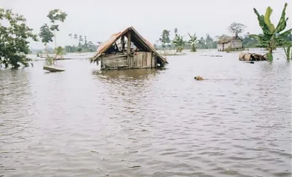
Figure 4. Flooding in peatland village desa Sungai Aur, Jambi. One factor that must be considered in programs to develop agricultural land on peat ... 39
Figure 5. Water management in plantations on peatlands growing pinang in Desa Mendahara Hulu, Jambi (left) and oranges in Desa Basarang, Central Kalimantan (right). How long will these last? Remember, peatlands are prone to subsidence ... 40
Figure 6. Diagram showing the proposed work mechanism for the implementation of the national peatland management strategy at central level ... 58
Figure 7. Flow chart of the monitoring and evaluation process ... 66
BOXES BOX 1 Canal blocking in South Sumatera & Central Kalimantan ... 11
BOX 2 Using blocked ditches/channels for aquaculture ... 16
BOX 3 Succession trends in burnt peatland (Wibisono et al., 2005) ... 33
BOX 4 Training on Fire Fighting in Desa Sungai Aur (Sri Najiyati et al., 2005) ... 34
BOX 5 The fate of illegal loggers in peat swamps in South Sumatera ... 36
BOX 6 Experience of rehabilitating burnt forest in Berbak National Park, Jambi (Wibisono et.al 2005) ... 37
BOX 7 Comparative study by peatland farmers from Central Kalimantan to Jambi and South Sumatra and vice versa ... 38
Glossary of Terms and Abbreviations
Alluvial : An area where sand or clay or similar materials are gradually sedimented by running water.
AMDAL : Environmental Impact Assessment (Analisis Mengenai Dampak Lingkungan)
AMMH : ASEAN Ministerial Meeting on Haze
APBD : Regional Budget (Anggaran Pendapatan dan Belanja Daerah) APBN : National Budget (Anggaran Pendapatan dan Belanja Negara)
APMI : ASEAN Peatland Management Initiative
APMS : ASEAN Peatland Management Strategy
ASCC : ASEAN Socio-Cultural Community ASEAN : Association of South East Asian Nations
ASOEN-HTTF : ASEAN Senior Officials on the Environment - Haze Technical Task Force
Bakornas PBP : National Coordination Agency for Disaster Management and Refugees (Badan Koordinasi Nasional Penanggulangan Bencana dan Penanganan Pengungsi)
Balitbang : Research and Development Agency (Badan Pelitian dan Pengembangan)
BAPPEDA : Regional Development Planning Agency (Badan Perencanaan Pembangunan Daerah)
BAPPENAS : National Development Planning Agency (Badan Perencanaan Pembangunan Nasional)
Base Saturation (BS) : The percentage of base cations in a soil complex. Base saturation is closely related to soil pH. If the pH is high, the base saturation will also be high, and similarly if soil pH is low the base saturation will be low also
Beje : A long rectangular fishpond, commonly dug in the middle of peatswamp forests or peatlands by the rural people in Central Kalimantan. The ‘beje’ ponds are usually not far from a river and are positioned behind the dwellings
BMG : Meteorology and Geophysics Office (Badan Meteorogi dan Geofisika)
BPPT : Agency for the Assessment and Application of Technology (Badan Pengkajian dan Penerapan Teknologi)
Bulk Density : The weight of a volume of undisturbed peat soil expressed in units of gr/cc or kg/m3. Values range between 0.10-0.40 gr/cc, depending on the peat’s level of maturity
Canal blocking : Construction of dams to block canals, ditches and channels CBD : Convention on Biological Diversity.
CCFPI : Climate Change Forests and Peatlands in Indonesia, is a forestry project which is closely related to the issue of climate change, where the forest plays an important role in carbon sequestration. This project is implemented by WI-IP together with Wildlife Habitat Canada (WHC) and funded by grants from the Canadian Goverment (CIDA, Canadian International Development Agency) through the Canada Climate Change Development Fund for a period of four years (August 2001 – September 2005), then extended to December 2006. Activities under this Project involve the participation of community and government in the conservation and rehabilitation of peatlands and peat forests in Indonesia. This Project was specifically designed to support the United Nations Framework Convention on Climate Change (UNFCCC) for Canada and Indonesia.
CC-GAP : Coordinating Committee on Global Action on Peatlands
CDM : Clean Development Mechanism
CEC : Cation Exchange Capacity. The capacity to absorb cations dissolved in soil per weight unit of soil
Cellulose : A polymer (long chain) of carbohydrate molecules produced by a plant. Cellulose is the material from which cell walls are composed, usually in the form of fibres, that form the largest part of plant mass.
CIDA : Canadian International Development Agency
CITES : Convention on International Trade in Endangered Species of Wild flora and fauna
Classification of grain size and rheological characteristics : Used to determine the properties of soil composition. Soil grain size greater than 2.0 millimicrons (loamy skeletal, sandy skeletal) and rheological properties showing shape deformation and flow that forms cohesive force and soil grain cohesion
Decomposition : The breaking down of organic material by living creatures (mainly bacteria and moulds) in the environment, that produces inorganic compounds or simpler organic compounds.
Deptan : Ministry for Agriculture (Departemen Pertanian)
Ditjen. Bina Bangda : Directorate General for Regional Development, Ministry of Home Affairs (Direktoral Jenderal Bina Pembangunan Daerah, Departemen Dalam Negeri)
Ditjen PHKA : Directorate General for Forest Protection and Nature Conservation, Ministry for Forestry (Direktorat Jenderal Perlindungan Hutan dan Konservasi Alam, Departemen Kehutanan)
Endemic : Limted in its distribution to only one specific site or area
Fire Break : A piece of land used to separate, stop, and control the spread of land/forest fire. Fire breaks can be natural, such as river chasms and empty land; or they may be man-made, such as roads, reservoirs, ditches and belts that have been cleared of litter and trees
Floodplain : A plain or basin near a river that experiences flooding/ inundation during the rainy season or at high tide, for example the flood plains in South Sumatera.
GEC : Global Environmental Center, a NGO based in Kuala Lumpur Malaysia
GEF-UNEP : Global Environment Facility -- United Nations Environmental Programme
GHG : Green House Gases: certain gases in the atmosphere that can obstruct/prevent the escape of infrared radiation from the earth, with the result that the average temperature of the earth’s surface is getting warmer. This resembles the trapping of infrared radiation inside a greenhouse, thus raising the temperature. The Kyoto Protocol lists six types of GHG whose emissions must be regulated/reduced: carbon dioxide (CO2), nitrous oxide (N2O), methane (CH4), sulphur hexafluoride (SF6), perfluorocarbon (PFC), and hydrofluorocarbon (HFC).
Giga : 109 (1,000,000,000) E.g. 1 Giga ton = 1,000,000,000 ton HPH : Forestry Licence (Hak Pengusahaan Hutan)
HRGMK : The peatswamp forest of Merang-Kepahiyang (Hutan Rawa Gambut Merang – Kepahiyang) in Kabupaten Musi Banyuasin, South Sumatera
HTI : Industrial Forest (Hutan Tanaman Industri) HTTF : The Haze Technical Task Force
Illegal logging : The illegal extraction of forest timber that disadvantages the nation and tends to ignore environmental regulations
Irreversible : Unable to be restored to its natural/original condition
Irreversible desiccation : A physical property of peat, which after becoming dry is no longer able to absorb water even if inundated
IUCN : International Union for Conservation of Nature and Natural Resources
Keppres : Presidential decree (Keputusan Presiden)
Kpts : Decree/decision (Keputusan)
LAPAN : National Institute for Aeronautics (Lembaga Penerbangan dan Antariksa Nasional )
LIPI : Indonesian Institute of Sciences (Lembaga Ilmu Pengetahuan Indonesia)
LREP : Land Resources Evaluation and Planning Project
LSAPSMP : Local Strategy and Action Plan for Sustainable Management of Peatlands
LSM : Non-governmental organisation (Lembaga Swadaya Masyarakat) Lignin : A chemical compound that forms the biggest component of wood
and forms part of the cell walls. The mass of lignin can reach 1/3 of the entire dry weight of wood. This compund is the second most abundant compound on earth after cellulose.
Mendagri : Minister for Home Affairs (Menteri Dalam Negeri) MenHut : Minister for Forestry (Menteri Kehutanan)
Men LH : Minister for the Environment (Menteri Lingkungan Hidup)
NGO : Non-governmental Organisation. A non-profit organisation managed outside the political structure with the purpose of achieving a particular social aim.
NSAPSMP : National Strategy and Action Plan for Sustainable Management of Peatlands
Parit : Ditch, a small channel (width 0.5 – 3 m; depth 0.6 – 1.5 m length up to 13 km), made in peatland, usually dug by individuals or groups to transport logs and/or other forest products
Peat : (organosol or histosol) soil formed from the accumulation over a long period of time of organic matter such as the remains of plants. Peat soil is generally waterlogged or flooded all year long unless drained. Several experts have defined ‘peat’ in different ways:
• According to Driessen, 1978: peat is soil containing more than 65% organic material (dry weight) and having a peat depth greater than 0.5 m.
• According to “Soil Taxonomy”: peat is soil comprised of organic materials with a thickness exceeding 40cm or 60cm, depending on the bulk density and level of decomposition of the organic matter
Peat dome : The central part of peatland, which rises like a dome. This part is usually less fertile because its nutrients come only from rainwater.
PEMDA : Regional Government (Pemerintah Daerah) PERDA : Regional Regulation (Peraturan Daerah)
PERPRES : Presidential Regulation (Peraturan Presiden) – previously termed Presidential Decree (Keppres= Keputusan Presiden)
PINSE : Yayasan Pinang Sebatang, a local NGO in Jambi
PLG : Proyek Lahan Gambut – the one million hectare peatland project developed in Central Kalimantan in 1995 during the era of President Suharto. The project was officially terminated in 1999 during the term of President Habibi because it was considered to be a failure.
POKJA PLGB : Working Group on Sustainable Peatland Management (Kelompok Kerja Pengelolaan Lahan Gambut Secara Berkelanjutan)
Porosity : A grade that indicates the number of pores in a medium (soil, gravel or stone) through which water or air can pass.
PP : Government Regulation (Peraturan Pemerintah) PU : Public Works (Pekerjaan Umum)
PUS-DALKARHUTNAS : National Forest Fire Control Centre (Pusat Pengendalian Kebakaran Hutan Nasional)
Pyrite : A soil layer containing more than 0.75% iron sulphide (FeS2). If marine soil (also shallow coastal peat soil) containing pyrite is reclaimed (e.g. by opening drainage channels so that the water level falls and the pyrite environment is exposed to an aerobic atmosphere) the pyrite will be oxidized to produce sulphuric acid with the result that the soil reacts by becoming highly acidic and highly dangerous to plants and organism in its waters
Ramsar : An international convention on wetlands. Indonesia ratified this convention in 1992
Red data book : A list of species threatened with extinction.
Reservoir : A body of water (usually constructed) capable of storing large quantities of water
RHAP : Regional Haze Action Plan
RLKT : Land Rehabilitation and Soil Conservation (Rehabilitasi Lahan dan Konservasi Tanah)
RTRWP : Provincial Spatial Planning (Rencana Tata Ruang Wilayah Propinsi)
SK : Decree/decision (Surat Keputusan)
Soil buffer capacity : The force exerted by the soil on a force that is exerted on top of it. The value of this force is required primarily when building irrigation constructions such as dams, water gates, or when establishing plantations.
SRFA : Sub-Regional Firefighting Arrangement
SRTDPLGB : Strategi dan Rencana Tindak Daerah Pengelolaan Lahan Gambut Berkelanjutan (see LSAPSMP)
SRTNPLGB : Strategi dan Rencana Tindak Nasional Pengelolaan Lahan Gambut Berkelanjutan (see NSAPSMP)
Subsidence : In a geological, technical or mapping survey context, subsidence is defined as the downward movement or collapse of a surface (usually the earth’s surface) relative to a certain datum – usually sealevel. The opposite of subsidence is uplift, which raises up the surface. In the context of peatlands, subsidence means the collapse of the peat’s surface, usually as a result of over-drainage or damage to its hydrology and vegetation, oxidation of the peat.
Tabat/tebat : (from the Dayak language) This is a barrier or dam constructed across a drainage channel/ditch in order to reduce the drainage of water and prevent the peat from drying out in the dry season
THR : Grand Forest Park (Taman Hutan Raya) TN : National Park (Taman Nasional)
UNEP : United Nations Environmental Programme
UNFCCC : United Nations Framework Convention on Climate Change
UU : Law (Undang Undang)
UNDP : United Nations Development Programme
WB : World Bank
WBH : Yayasan Wahana Bumi Hijau, a local NGO in Palembang, South Sumatera
WHC : Wildlife Habitat Canada, a NGO in Canada
WI-IP : Wetlands International-Indonesia Programme, an international non-profit organisation active in the field of wetlands conservation
WWF-Indonesia : World Wide Fund for Nature Indonesia
1. Introduction
Background to the creation of the National Strategy and Action Plan for
Sustainable Management of Peatlands
Peatlands have an extremely important role to play in the lives of the humans and other creatures that live on and around them. Peatlands do not only function as a direct life support system (for example, as a source of freshwater fish, a habitat for a diversity of living creatures) but also have a variety of ecological functions like flood control and global climate control. Peatland areas are difficult to restore once they are damaged. Therefore, to preserve the ecological ecosystem of peatlands it is necessary to manage them wisely, paying proper attention to ecological equilibrium, for the interests of current and future generations.
As a part of wetlands, peatlands have in fact been mentioned in the National Wetlands Management Strategy (Strategi Pengelolaan Lahan Basah Nasional). Nevertheless, in view of their specific characteristics and the vast extent of Indonesia’s peatlands (approximately 20 million Ha or 50% of the world’s total tropical peatlands), it is deemed necessary to develop a management strategy specifically for peatlands. The development of the National Strategy and Action Plan for Sustainable Management of Peatlands is also the result of a number of other considerations, including the following:
In order to maintain the functions and benefits of the peatland natural resource, there needs to be a balance between its conservation and sustainable use. This can be achieved based on identification of existing potentials and problems, using an approach that balances the needs for conservation against those of utilisation.
The management of natural resources, including peatlands, cannot be carried out by a single party alone, but requires the efforts and cooperation of a number of parties, such as government, NGOs, institutes of higher education, the private sector, and the community. This requires cooperation to achieve optimal, sustainable use of this natural resource.
Implementing decentralisation at local level requires the assignment of strict, clear management functions, as well as open, continuous communication among stakeholders. For this, a guide is needed which is national in character but which can be described in different regions and adapted to the local conditions.
A number of meetings related to peatlands, at both national and international level, have also prompted the development of this National Strategy and Action Plan for Sustainable Management of Peatlands. Some of these meetings and their recommendations are as follows. The international symposium on tropical peatlands (Annex 11a) entitled "Peatlands for
The workshop on the wise use and sustainable management of peatlands Pemanfaatan Bijaksana serta Praktek-praktek Pengelolaan Lahan Gambut yang Berkelanjutan held in Bogor on 13 – 14 October 2003 (Annex 11b), resulted in a statement urging the government, non-government organisations, private sector and communities to work together to protect, rehabilitate and sustainably manage peatlands for the benefit of present and future generations and for the global environment.
The Riau Declaration (Annex 11c) produced by the international Workshop on Vulnerability of Carbon Pools in Tropical Peatlands” held 23-26 January 2006 in Pekanbaru underlined, among other things, the need to “strengthen policies and institutional arrangements for peatland management and strictly enforce policies and rules for the management and conservation of peatlands”.
During 9-11 April 2003, the Seminar on Wise Use and Sustainable Management of Peatlands was held in Narathiwat, Thailand (Annex 11d). This examined 2 main topics: the rehabilitation and management of peatlands, and the sustainable use of peatlands and community participation. The seminar produced a number of recommendations contained in the Narathiwat Statement on Wise Use and Sustainable Management of Peatlands. This welcomed the establishment of the ASEAN Peatland Management Initiative in March 2003 and the Ramsar Convention Guidelines on Global Action on Peatland. The Seminar also stated that it was important to “urgently stop the loss and degradation of peatlands in SE Asia and promote their sustainable management”. The main points of the action plan recommended by the Narathiwat Statement which urged prompt adoption of the NSAPSMP include: (a) “Establish national inter-agency working groups to develop strategies for peatland protection and sustainable use” (b) “Formulate or update national policies and strategies or action plans for conservation and wise use of peatlands” (c) “Develop overall management plans for each peatland area to include forest, water and fire management as well as community participation and utilization of resources”.
Besides being discussed in a number of national and international level meetings, peatlands have also received attention in several international conventions since the beginning of the present millennium. Such international conventions include: the Convention on Biological Diversity (CBD), the United Nations Framework on Climate Change (UNFCCC) and the Ramsar Convention. In fact, the last of these addressed the issue of peatlands back in 1996 during Ramsar Convention COP 6 in Brisbane, Australia.
The Convention on Biological Diversity (CBD) through its resolution on Biological Diversity and Climate Change encouraged actions to mitigate the degradation and promote the restoration of peatlands as carbon stores and/or to maintain their capacity to absorb carbon. In addition, CBD also supported the studies of peatland biodiversity and climate change carried out by international NGOs (Wetlands International and Global Environment Center). This convention also pointed out the need to combine peatland issues into a work programme on inland water biodiversity.
The Ramsar Convention has acknowledged the need to pay more attention to the conservation and wise use of peatlands and their role in controlling climate change. In 2002, this convention formed a Coordinating Committee to monitor developments in the implementation of Manuals on Global Action on peatlands (CC-GAP, Coordinating Committee on Global Action on Peatlands), and to produce an Action plan as a further step, and to identify action priorities within the framework of promoting the wise use of peatlands.
The Action plan developed by CC-GAP is an important step forwards for the global agenda in promoting the wise use of peatlands. It provides direction/guidance on many conventions and their member countries, related to the peatland issues arising and the main priorities for action.
The following are Ramsar Convention resolutions related to peatlands:
Article 1 of the Ramsar Convention specifically states that peatlands are included within the connotation of the definition of wetlands. This means that peatlands will always form part of the term ‘wetlands’ wherever it appears within the Convention.
Recommendation 6.1 (1996, COP 6) on “peatland conservation” urges stakeholders to inventorise peatlands, develop guidelines for the management of peatlands at regional level, recommend that the Guidelines for the Wise Use of Wetlands published by the Ramsar Convention be fully applied to peatlands, that international mechanisms for coordination and cooperation on peatland conservation initiatives be expanded, and encourage research into the functions of peat and their restoration.
Recommendation 7.1 (1999, COP 7) on “the wise use of peatlands” presents a “Global Action Plan for the management and wise use of peatlands”
Resolution VIII.3 (2002, COP 8) tells relevant countries to minimise the degradation of peatlands and to promote the restoration of degraded peatlands which are of important value as carbon stores.
Resolution VIII.17 (2002 COP 8) adopted the “Guidelines for Global Action on Peatlands” and established the CC-GAP.
The development of a National Strategy and Action Plan for Sustainable Management of Peatlands (NSAPSMP) for Indonesia became urgent due to the pressing need from the local, national, regional and even international communities for wise use and sustainable management of peatlands. The routine incidence of forest and peatland fires together with the associated haze, resulting from the unwise management and use of forests and peatlands, have caused great economic, environmental and health losses for the people of Indonesia (particularly in Sumatra and Kalimantan) and neighbouring countries, and could bring about global climate change. The peatland management strategy for Indonesia has been developed with reference to the framework of the ASEAN Peatland Management Initiative (APMI) and the ASEAN Agreement on Transboundary Haze Pollution contained in the ASEAN Peatland Management Strategy (APMS). It refers also to the stipulations contained in the Ramsar Convention, the Convention on Biological Diversity and the National Wetlands Management Strategy.
The development of a regional strategy, the ASEAN Peatland Management Strategy (APMS), was one item in the work plan of the APMI (2003 – 2005) adopted at the ASOEN-HTTF meeting in the Philippines, 28 February 2003. Besides agreeing on the strategy framework, the meeting also decided that each member country should prepare information and a country paper for discussion at the APMI regional workshop in October 2003 in Bogor, Indonesia.
The First Regional Workshop on the APMI, on 16-17 October 2003 in Bogor, collectively agreed to prepare an ASEAN Peatland Management Strategy (APMS). This regional strategy would be based on information collected from each country attending the meeting and other appropriate materials. A variety of inputs were subsequently collected and synergised into a draft regional strategy document (APMS) prepared by the ASEAN Secretariat with technical support from the Global Environment Centre and Wetlands International, during the period December 2003 to June 2004. As several countries had been unable to attend the regional workshop, this document still required their inputs as well as further polishing. Finally, on 15 November 2005, at the 22nd Meeting of the ASEAN Senior Officials on the Environment Haze Technical Task Force (ASOEN-HTTF) in Bandar Seri Begawan, Brunei Darussalam, the “Strategy and Action Plan for Sustainable Management of Peatlands in ASEAN Member Countries” (APMS) with a duration of 15 years: 2006 – 2020, was officially accepted by the ASEAN member countries.
Characteristics and Systematization of the National Strategy and Action Plan
for Sustainable Management of Peatlands
This NSAPSMP is the master plan for: peatland conservation, peatland utilisation, and the control and handling (rehabilitation) of peatland degradation. This master plan will be the basis for drawing up peatland management programmes that will be further described in the action plan of each relevant Central agency. As peatland conditions vary from place to place, the order of priorities/needs in peatland management will be determined to suit local requirements.
The NSAPSMP is divided into two parts. The first part provides background information on peatlands in Indonesia, including information on definitions, distribution, area, status, utilisation, policies and institutions involved in peatland management, issues and problems that arise, needs and general recommendations for each level of government: provincial, district (kabupaten), municipal.
The second part contains information on the development of the strategy itself, including its background, formulation, reasons/justification for the need for such a strategy at national level, detailed and general objectives accompanied by details of actions, and an initial framework for implementing the strategy.
The strategy focuses primarily upon the following four objectives: Raise awareness and knowledge concerning peatlands Address peatland degradation
Promote the wise, sustainable management of peatlands
The operational objectives of this national strategy (NSAPSMP) are designed to describe the objectives above along general lines only, for use as a guide by District/Municipal and Provincial Governments when drawing up a more detailed Peatland Management Action Plan at District/Municipal or Provincial level, which is adapted to the prevailing local conditions.
Considering that it is increasingly important to have a network or cooperation among district/provincial [even regional and international] levels in order to address the issues of peatland fires and haze, conservation and sustainable management, and enhanced capacity for peatland management and research, this strategy is expected to play an important role as a form of formal cooperation among District, Municipal and Provincial governments [and even the Regional ASEAN level], through the exchange of technology and expertise as well as technical assistance to overcome the various problems of peatlands in each area.
2. Peatlands in Indonesia
This section defines peatlands and provides information on their distribution, extent, values and uses, and on relevant policies and institutions, problems and threats, management and cooperation among District, Municipal and Provincial levels in the management of peatlands in Indonesia. The information given here was obtained from a number of written sources supplied by technical agencies, research institutes, universities, NGOs and other competent sources in the area of peatland studies.
2.1
Definitions and Characteristics of Peat
Peatlands constitute a wetland ecosystem formed from the accumulation of organic matter on the forest floor, originating from the debris of the vegetation above it over a very long period of time (thousands of years). This occurs because the rate of decomposition is slow compared to the rate at which the organic matter accumulates on the wet/inundated forest floor.
Peatland is organosol or histosol soil that is always saturated with water or inundated throughout the year, unless it is drained. Different experts have defined peat in different ways. Two of the definitions commonly used are:
Peat is soil containing more than 65% organic material (dry weight) and having a peat depth greater than 0.5 m (Driessen, 1978)
Peat is soil comprised of organic materials with a thickness exceeding 40cm or 60 cm, depending on the bulk density and level of decomposition of the organic matter (Soil Taxonomy).
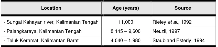
The formation of peat in many coastal areas of Indonesia is thought to have begun during the last glacial age, about 3,000 – 5,000 years ago. The formation process for deep peat is even older, starting around 10,000 years ago (Brady 1997 in Daniel Murdiyarso et al, 2004). Table 1 below shows the age of peatlands at several locations in Kalimantan.
Table 1. Estimated age of peatland at several locations in Kalimantan
Location Age (years) Source
- Sungai Kahayan river, Kalimantan Tengah 11,000 Rieley et al., 1992 - Palangkaraya, Kalimantan Tengah 8,145 – 9,600 Neuzil, 1997
- Teluk Keramat, Kalimantan Barat 4,040 – 1,980 Staub and Esterly, 1994
Like other tropical peat, Indonesia’s peat was formed by the accumulation of tropical vegetation residue rich in Lignin and Cellulose (Andriesse, 1988). Due to the slow process of decomposition, heaps of twigs, branches and roots of large plants are often found preserved in the peat, with their structure still relatively clear to see.
As a wetland ecosystem, peat possesses unique characteristics compared to other ecosystems. These can be seen from its chemical and physical properties. Chemically, its fertility varies but is generally low. This is signalled by the peat soil’s acidity (low pH), low availability of macro (K, Ca, Mg, P) and micro (Cu, Zn, Mn, and Bo) nutrients, the presence of toxic organic acids, and high Cation Exchange Capacity (CEC) but low Base Saturation (BS) .
The physical properties of peat, which are unique and need to be properly understood, include maturity, colour, bulk density, porosity, irreversible desiccation, subsidence, and high combustibility. As regards maturity, peat has a variable level of maturity because of the differences in the materials, environmental conditions and time involved in its formation. Mature peat (sapric type) tends to be finer and more fertile. Conversely, immature peat (fibric type) contains a lot of coarse fibre and is less fertile.
Peat also varies in colour. Although the original materials were grey, brown or red, after decomposition dark coloured compounds appear (Nurhayati et al, 1986) with the result that the peat (also peat water) is generally brown to black in colour. Colour is one indicator of the peat’s maturity. The more mature the peat, the darker its colour. Fibric is brown, haemic is dark brown, and sapric is black (Darmawijaya, 1990). When wet, the peat is usually darker.
Peat has a much lower bulk density than alluvial soil. The more mature the peat, the higher its bulk density. Besides this, peat has a low soil buffer capacity because its large pores result in lightweight soil with low cohesion. Total pores for fibric/haemic materials is 86-91 % (volume) and for haemic/sapric 88-92 %, or around 90 % volume on average (Suhardjo and Dreissen, 1977). As a result, trees that grow on it easily fall over. The low soil buffer capacity is a problem in constructing irrigation channels, roads, housing, plantations and rice-fields.
Peat also possesses rapid horizontal hydraulic conductivity which accelerates the leaching of nutrients into drainage channels. Conversely, its vertical water-conduction capacity (upwards) is extremely slow, with the result that the surface layer of the peat often dries out, even though the layer below is wet. This also impedes the supply of water to the layer where roots are growing. Besides this, peat is also characterised by irreversible desiccation. This means that it will be very difficult for peat that has experienced extreme drought to absorb water again.
Peatlands tend to be easily combustible due to their high content of organic materials, irreversible desiccation, high porosity, and low vertical hydraulic conductivity. Peatland fires are extremely difficult to put out because they can travel underground. Embers thought to have been extinguished lie beneath the surface and, unbeknown, continue to spread the fire to surrounding areas. Embers in deep peat can usually be extinguished only by heavy rainfall. For this reason, peat fires must be prevented by not burning peatlands, not irresponsibly discarding even the tiniest spark of fire such as cigarette stubs, especially during the dry season, and keeping peat soil moist by not constructing excessive drainage.
2.2
Distribution and Extent of Peatlands in Indonesia
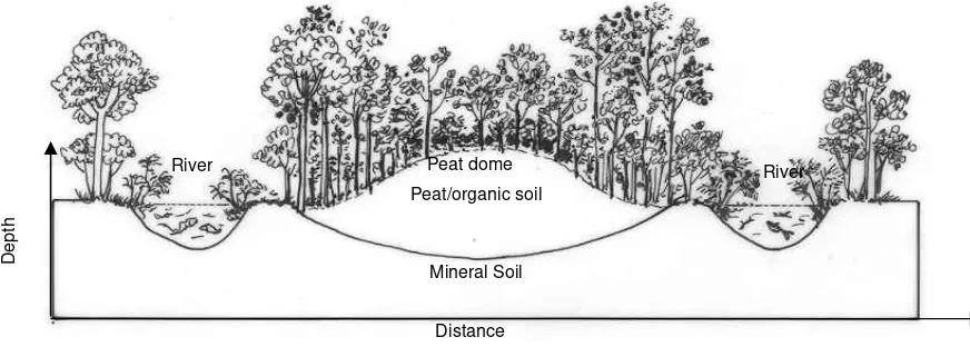
Indonesia’s peatlands are distributed in swampland, that is land situated at the transition between terrestrial and aquatic ecosystems. For all, or most, of the year, this land is continuously waterlogged or inundated. Peat occupies basins, depressions and the lowest parts of valleys, and its distribution ranges from lowland plains to highland plateaux. In Indonesia, most peatlands are found in lowland swamp plains along the coast. The extent of these peatlands is vast, usually occupying depressions between large rivers near the estuaries, where the rise and fall of the groundwater is influenced by the daily ocean tides. The peat dome and plain usually stretch across a wide basin between large rivers, extending upstream from the coastal plain (see Figure 1).
Figure 1. Cross section of peat dome
Indonesia is the country with the world’s fourth largest area of peatlands (Euroconsult, 1984), with about 20 million ha, after Canada (170 million ha), the former Soviet Union (150 million ha), and the USA (40 million ha). However, different reports (see Table 1) give widely different figures for the extent of Indonesia’s peatlands, ranging from 13.5 million to 26.5 million ha (average 20 million ha). If we take 20 million ha as an estimate, this means that around 50% of the world’s tropical peatlands (totalling approximately 40 million ha) are in Indonesia. Note that data on the extent of Indonesia’s peatlands has not been standardised and therefore the range 13.5 – 26.5 million ha is still used.
Distance
Depth
Mineral Soil Peat/organic soil
Table 2. Estimated extent and distribution of peatlands in Indonesia according to several sources
Peat distribution (in millions of hectares) Author/Source
Sumatera Kalimantan Papua Other
Total
* does not include peat associated with saline land or flood plain (2.46 million ha); - (no data available)
This wide variation in figures is due to the fact that a detailed, intensive survey has not yet been carried out specifically focused on peatlands in Indonesia. Nevertheless, it can be seen from Table 2 that the largest areas of peatlands are in, respectively, Sumatera, Kalimantan then Papua. Of these three large islands outside Java, only the swamp lands on the east coast of Sumatera, and some of those in Kalimantan (West, Central and South Kalimantan) have been researched in any detail, which was between 1969 – 1979, during the Proyek Pembukaan Persawahan Pasang Surut (Tidal Rice-field Project) in those areas. Then during 1987-1991 the LREP-I (Land Resources Evaluation and Planning Project) carried out by the Soil Research Centre also mapped the peatlands in the whole of mainland Sumatera at observation level on a scale of 1:250,000.
Later in 2002-2004 Wetlands International - IP specifically carried out the updating and mapping of peatlands in Sumatera and Kalimantan on a scale of 1:250,000 (Annexes 1 and 2). This was followed by a desk study (study of secondary data) of peatlands in Papua in 2006.
The extent of the peatlands (including very shallow peat or peaty mineral soil) in each province of Sumatera, starting with the largest area, is as follows:
i) Riau 4.044 million ha (56.1 % of total peatland area) ii) South Sumatera 1.484 million ha (20.6 %)
iii) Jambi 0.717 million ha ( 9.95 %) iv) North Sumatera 0.325 million ha ( 4.5 %) v) Nanggroe Aceh D. 0.274 million ha ( 3.8 %) vi) West Sumatera 0.210 million ha ( 2.9 %) vii) Lampung 0.088 million ha ( 1.2 %) viii) Bengkulu 0.063 million ha ( 0.88 %)
According to the thickness of the peat layer, in 2002 the composition of peatlands in Sumatera was as follows :
i) Very shallow peat (< 50 cm) 0.682 million ha ( 9.5 %); ii) Shallow peat (50 – 100 cm) 1.241 million ha (17.2 %); iii) Moderate (100 – 200 cm) 2.327 million ha (32.3 % iv) Deep peat (200 – 400 cm) 1.246 million ha (17.3 %). v) Very deep peat (> 400 cm – 800 cm) 1.705 million ha (23.7 %);
On the island of Kalimantan, the peatlands (total area 5,769,246 Ha) are generally distributed on the lowland plains of Central Kalimantan (3,010,640 ha), followed by West Kalimantan (1,729,980 Ha), East Kalimantan (696,997 Ha) and South Kalimantan (331,629 Ha).
These extend up to 50 km inland/upstream from the coastline (Wahyunto et al., 2005). Narrower areas of peatlands are also found on the plateau in the western part of Kalimantan, particularly in the region of Danau Sentarum, Kapuas Hulu, Propinsi Kalimantan Barat.
The extent of the peatlands (including very shallow peat or peaty mineral soil) in each province of Kalimantan, starting with the largest area, is as follows:
i) Central Kalimantan 3.011 million ha (52.2 % dari luas total lahan gambut) ii) West Kalimantan 1.730 million ha (30.0 %).
iii) East Kalimantan 0.697 million ha (12.1 %). iv) South Kalimantan 0.332 million ha ( 5.7 %).
According to the thickness of the peat layer, in 2003, the composition of peatlands in Kalimantan was as follows :
i) Very shallow peat ( < 50 cm) 0.190 million ha ( 3.3 %). ii) Shallow peat (50 – 100cm) 1.741 million ha (30.2 %); iii) Moderate (100- 200 cm) 1.391 million ha (24.1 %); iv) Deep peat (200 – 400 cm) 1.105 million ha (19.1 %). v) Very deep peat (400 – 800 cm) 1.065 million ha (18.5 %); vi) Extremely deep peat (> 800 cm-14m) 0.278 million ha (4.8%)
For other places, such as Papua, Sulawesi and Halmahera, no detailed, comprehensive field study of the extent and distribution of peatlands has yet been carried out.
2.3
Values and Uses of Peatlands in Indonesia
People began to talk a lot about peat ten years ago when the world started to realise that this natural resource did not just function as a hydrological regulator, a habitat for the conservation of biodiversity, a cultivation site and an energy source, but also played an even more significant role in the control of global climate change because of its capacity to sequester and store the world’s carbon reserves.
1. Hydrological Regulator
Peat is highly porous and therefore able to soak up huge quantities of water. When saturated, sapiric, haematic and fibric peat respectively can contain water amounting to as much as 450%, 450 – 850%, and more than 850% of the peat’s dry weight or up to 90% of its volume. Because of this, peat possesses the capacity to function as a large freshwater reservoir, to the extent that it can prevent flooding in the wet season and release water during the dry season, and prevent intrusion of salt water inland.
The peat’s function as a hydrological regulator can be disturbed if it experiences excessive drainage conditions, because this material is characterised by irreversible desiccation, high porosity, and low vertical conductivity. Peat that has dried out to the point of irreversibility will be extremely lightweight and thus easily washed away by rainwater, its structure falls apart like layers of litter, it burns easily, is very poor at reabsorbing water, and is difficult to replant.
BOX 1
Canal blocking in South Sumatera & Central Kalimantan
Many ditches have been constructed illegally by people living in S. Merang-Kepahiyang Kab. Musi Banyuasin, South Sumatra for the purpose of extracting felled timber during the rainy season. Along the Merang river, about 113 ditches were found, of which 83 were in peatlands. The ditches had been constructed using a chainsaw and measured 1.7 – 3 m wide, 1.5-2.5 m deep and 1.5-5 km long. Several of these channels are no longer used and there are indications that they have caused the peat to dry out excessively during the dry season and eventually to catch fire. To avoid the drying/burning of peat in this area, the CCFPI Project and Wetlands International worked together with local NGOs (WBH , Wahana Bumi Hijau) during May – December 2004 to facilitate the blocking of 8 ditches by their owners. Similar action was taken on 18 ditches/channels on peatlands in the discontinued million-hectare PLG Mega rice project in Central Kalimantan. All these canal-blocking activities were carried out with the participation of the community and the support of the local government. As a result of the activities, the peat remained wet during the dry season and the vegetation around the ditches grew well.
Canal blocking at S. Merang-Musi Banyuasin-Sumsel (width 2 meters)
2. Habitat for the conservation of biodiversity
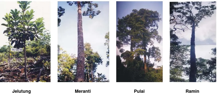
Peat is found on only a small part of the earth’s surface. The world’s peatlands are estimated at just 400 million ha, which is only about 2.5% of the land on the face of the earth. Their limited extent and unique characteristics make peat a unique habitat for a diversity of flora and fauna. Some of these plants can grow well only on peatland, so if these lands are degraded, the world will lose many species of flora as these cannot grow in other habitats. In Sumatera, more than 300 plant/tree species have been found in peat swamp forest (Giesen W, 1991). Examples of species specific to peatland and which have high economic value are jelutung (Dyera custulata), ramin (Gonystylus bancanus), Meranti (Shorea spp), Kempas (Koompassia malaccensis), Punak (Tetramerista glabra), Perepat (Combretocarpus royundatus), Pulai rawa (Alstonia pneumatophora), Terentang (Campnosperma spp), Bungur (Lagestroemia spesiosa), and Nyatoh (Palaquium spp) (Iwan Tricahyo W, Labueni Siboro, and Suryadiputra, 2004). Rare animal species also found in this habitat include the sinyulong crocodile (Tomistoma schlegelii), sumatran tiger (Panthera tigris sumatrae), sun bear (Helarctos malayanus), tapir (Tapirus indicus), white winged wood duck (Cairina scutulata), and the lesser adjutant (Leptoptilos javanicus) a protected species of water fowl listed in Appendix I of CITES and entered in the category of Vulnerable in the IUCN Red Databook .
The biological diversity of species living in peatland habitat is a gene pool resource that can be used to improve the characteristics of commercial varieties or species of flora and fauna in order to produce commodities that are resistant to disease, highly productive, or have other beneficial characteristics.
Jelutung Meranti Pulai Ramin
Figure 2. Species of trees growing in peatlands (Photo: Iwan Tri Cahyo W./Dok. WI-IP)
3. Global climate safeguard
Climate change is a global phenomenon signalled by changes in temperature and rainfall patterns. The biggest contributor to climate change is the increasing concentrations of ‘greenhouse’ gases in the atmosphere, such as carbon dioxide (CO2), methane (CH4), and nitrous oxide (N2O) whose concentrations continue to increase (Daniel Murdiyarso and Suryadiputra, 2004). These gases absorb long wave radiation, which is hot and will cause the earth’s temperature to rise as the quantity of such gases in the atmosphere increases.
A global increase in air temperature will change the world’s climate pattern, altering rainfall distribution, wind direction and wind speeds. All this will impact directly on Earth’s various life forms, such as the development of diseases in animals, humans and plants; changes in plant productivity; drought, flooding, and so on.
Peat has a very big Carbon (C) content. According to calculations by Matby and Immirizi (1993) in Daniel Murdiyarso and Suryadiputra (2004), the world’s peat contains 329-525 Gt or 35% of the world’s total C. The peat in Indonesia stores 46 GT (note: 1 GT = 109 ton) or 8-14% of the carbon present in the world’s peat. Thus, peat plays a significant role as a safeguard on global climate. If this peat burns or is degraded, it emits gases (mainly CO2, N2O, and CH4) to the atmosphere ready to cause global climate change. If this happens, we must be prepared to suffer the consequences.
4. Cultivation
The use of peatlands for the cultivation of plants (including oil palm plantations or HTI), livestock and fish has long been familiar to farmers and businesses in Indonesia. Small-scale traditional farming in peatlands was begun hundreds of years ago by the Dayak, Bugis, Banjar, and Melayu peoples. They selected sites wisely, chose well-tested commodities, and farmed on a scale that nature could support.
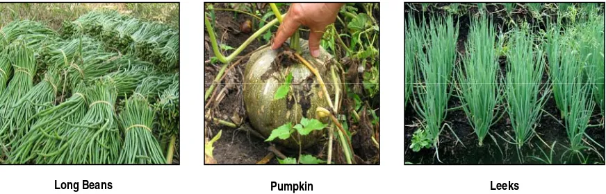
As the demand for agricultural commodities rose due to increasing economic and population growth, there was a rapid expansion in land for agriculture. Sadly, this expansion often paid little or no attention to the soil buffer capacity and characteristics of peatland. Poor planning was accompanied by the use of unsuitable land, inadequate implementation of the principles of land conservation, and the use of technology that tended to be less than appropriate. The result was widespread damage, and repeated failure of agriculture and plantations developed on peatlands. Conversely, however, the use of peatlands for agriculture and orchards on a limited scale, paying due attention to the principles of conservation and employing appropriate technologies, has proven to be productive and prosper the farmer.
Figure 3. Vegetables grown on peatland in Central Kalimantan and Jambi
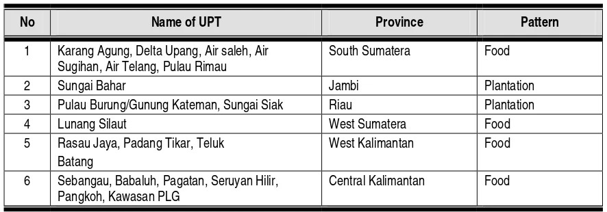
Along with efforts to optimise the potentials of peatlands for agriculture, the government used its transmigration programme to develop a number of transmigration settlements on peatlands. Their pattern of development was generally integrated with that of food crops and plantations. Some of these UPT transmigration sites on peatlands are listed in Table 3 below.
Table 3. UPT Transmigration settlements developed on peatlands
No Name of UPT Province Pattern
1 Karang Agung, Delta Upang, Air saleh, Air
Sugihan, Air Telang, Pulau Rimau
South Sumatera Food
2 Sungai Bahar Jambi Plantation
3 Pulau Burung/Gunung Kateman, Sungai Siak Riau Plantation
4 Lunang Silaut West Sumatera Food
5 Rasau Jaya, Padang Tikar, Teluk
Batang
West Kalimantan Food
6 Sebangau, Babaluh, Pagatan, Seruyan Hilir,
Pangkoh, Kawasan PLG
Central Kalimantan Food
However, the development of transmigration in peatland areas requires mature consideration and needs to be done extra carefully. Some of the limiting factors that cause transmigration on peatlands to fail are:
The transmigrants and their fields are placed on deep peat (> 2 metres) which is generally infertile and vulnerable to flooding in the rainy season and drought in the dry season.
Even if placed on shallow peatland (less than 1 m), much of the peat material will be washed away leaving the underlying mineral soil containing pyrites which, when oxidised, cause the soil to become highly acid and toxic to plants.
The transmigrants come from places where there is no peat (Java and Bali) so they have no knowledge of how to farm peatlands.
As a result of all these limiting factors, many transmigrants abandon the land they have tried to farm; some return to the place they came from, some change ‘profession’ to become illegal loggers in forest that is still relatively intact near the settlement.
5. Fish habitat
Table 4. Fish species found in blackwater (peat) rivers, swamps and lakes in and around Sungai Puning, Kab Barito Selatan
No Local Name Found in No Local Name Found in
GABUS SALUANG
1 Kihung R, L, B 21 Saluang Barik R,L, B
2 Miau R, B 22 S Sapapirang R,L
3 Peyang R 23 S Janah R,L
4 Tahuman R, L, B 24 S Bambayung R,L
25 S Batang R,L
BAUNG 26 S Juar R,L
5 Baung Kopa R 27 S Tengak R,L
6 Baung Langkai R, L 28 Tangkalasa *
7 Baung Gurai R, L 29 Kalabau R,L, B
8 Baung Bangku R, L 30 Tatumbuk Baner R,L, B
9 Baung Karangkam R, L 31 Janjulung R,L, B
32 Papuyu R,L, B
PATIN 33 Kakapar R,L, B
10 Lawang R 34 Pentet/Lele R,L, B
11 Riyu R 35 Puhing R,L
12 Patin Sabun R 36 Sangguringan R,L
37 Junu/Butia R,L
LAIS 38 Pipih R
13 L Banto R, L 39 Barbus R,L
14 L Bamban R 40 Darah manginang R,L
15 L Celeng R,L 41 Jajela R,L
16 L Nipis R, L 42 Pahi/pari R
LAINNYA 43 Patan R,L
17 Tapah R,L, 44 Jalawat R,L
18 Biawan R,L, B 45 Jalawat batu R,L
19 Sasapat R,L, B 46 Belut/lindung L
20 Kalui /Tambakang R 47 Karandang *
Key:
1) R = River (blackwater); L = Lake/swamp (blackwater); B = Blocked ditches/channels 2) * = very rarely found, almost extinct
3
In addition to the five values/uses described above, peatlands also possess other values and uses as detailed in Annex 3.
2.4
Policies and Institutions related to Peatland management
Policies
There has, so far, been little development of policies specifically (directly) governing the management of peatlands in Indonesia. Nevertheless, several policies related to the management of peatland forest fire have been published in the form of laws (Undang-undang), Government regulations (Peraturan Pemerintah), Presidential decrees (Kepres/Perpres), Ministerial decrees (Surat Keputusan Menteri), Director Generals’ decrees (Surat Keputusan Direktur Jenderal), Local regulations (Peraturan Daerah), and the decrees of Governors(Surat Keputusan Gubernur), Regents (Bupati), and Mayors (Walikota).
BOX 2
Using blocked ditches/channels for aquaculture
In Desa Muara Puning (in Kabupaten Barito Selatan-Kalteng), the ditches/channels in the peatland (3 – 11 km long) were usually rented out by the owners to illegal loggers to transport timber. After illegal logging ceased (because the timber resource had run out), these ditches were abandoned by their owners. Subseqently, WI-IP together with the local NGO Yakomsu (Yayasan Komunitas Sungai = river communiy foundation) and the local community took this opportunity to block the ditches/channels in order to prevent the peatland from losing water, drying out and potentially catching fire in the dry season. In fact, the blocking not only caused the water level in the channels to rise thus creating long ponds (similar to the “Beje” ponds generally dug by Dayak communities), but also functioned as fire breaks. Moreover, these ponds were also able to trap fish. The quantity of fish thus caught (mainly betok, gabus, sepat and lele) at the end of the rainy season was reported to reach 100 kg for each 500 m section of the blocked channels (1.2 m wide and about 1 m deep) and even amounted to 2 ton for a 3 km long section.
Left and centre: pictures of blocked ditch, and
The following are some of the policies that relate directly or indirectly to peat issues:
1. Laws (Undang Undang) a. UU No.5 year 1990
Regulation concerning the conservation of natural resources and their ecosystems -- Konservasi Sumber Daya Alam Hayati dan Ekosistemnya (Lembaran Negara tahun 1990 Nomor 49, Tambahan Lembaran Negara Nomor 3419). Contains basic regulations for the conservation of natural resources, covering the protection of life support systems, preservation of plant and animal species biodiversity and their ecosystems, sustainable use of natural resources and their ecosystems, and community participation in conservation activity.
b. UU No 12 year 1992
concerning plantations Perkebunan: emphasizes that plantation systems must be based on sustainable use and prevent environmental degradation and pollution
c. UU No. 24 year 1992
concerning spatial planning Penataan Ruang (Lembar Negara RI tahun 1992 Nomor 115, Tambahan Lembaran Negara RI Nomor 3501): peatland management must be based on spatial planning.
According to the book of peat distribution in Sumatra and Kalimantan (Wahyunto et al., 2004), peatlands in Sumatra and Kalimantan are distributed across 76 districts (Kabupaten) and municipalities (kota). This figure may change in line with regional developments. Based on data from Dirjen Bina Bangda, as per January 2005, of these 76 districts/municipalities, 27 are recorded as possessing regional regulations on spatial planning (Perda Tata Ruang). As only 36% of regions possess Perda Tata Ruang, increased effort needs to be made to encourage the regions to include peatland management promptly into their spatial planning.
d. Undang-undang No.5 year 1994
This law makes the United Nations Convention on Biological Diversity part of the policy governing biodiversity in Indonesia. This convention contains 42 articles concerning general efforts for the conservation and sustainable utilisation of biological diversity, raising the community’s level of concern, technological developments, and funding.
e. Undang-undang No.6 year 1994
f. Undang-undang No.23 year 1997
This law on management of the environment Pengelolaan Lingkungan Hidup (Lembaran Negara RI tahun 1997 Nomor 68, Tambahan Lembaran Negara RI nomor 3839) consists of 52 articles concerning terms related to environmental management; principles, aims and goals of environmental management in Indonesia; the community’s rights and obligations in managing the environment; provisions on environmental planning and conservation; enquiry, resolution of conflicts and sanctions for infringement of the environmental management regulations.
g. Undang-undang No.41 year 1999
Law on forestry Kehutanan as amended by government regulation Peraturan Pemerintah Pengganti Undang-undang Nomor 1 tahun 2004 tentang Perubahan atas UU Nomor 41/1999 tentang Kehutanan (Lembar Negara RI tahun 2004 Nomor 29, Tambahan Lembaran Negara Nomor 4374).
As stated in the section menimbang, UU no 41 1999 states that law Undang-undang No 5 year 1967 on Ketentuan-ketentuan Pokok Kehutanan (Lembaran Negara Tahun 1967 Nomor 8) is no longer in line with the principle of forest administration and authority, and the demands of changing circumstances, so needs to be replaced. The new law consists of 17 chapters, 84 articles. Important points in this law include :
• In chapter V, it is explained that rehabilitation, forest protection and nature conservation are all part of forest management in Indonesia.
• The fourth part of chapter V regulates on types of rehabilitation activity, location, implementation methods and the implementers of rehabilitation activities.
• The fifth part of chapter V regulates on provisions for forest protection and nature conservation, where forest fire prevention is part of forest protection.
• Article 48 paragraph 1 explains that the government regulates all aspects of forest protection, both within and outside the forest area
• Responsibility for fires is regulated in article 49 with the provision that the holders of forest management rights or licences are responsible for the occurrence of forest fire in their work territory.
• Forest protection efforts (including fire) are carried out with the involvement of the community (article 48 paragraph 5)
• Basically, everybody is prohibited from burning forest and from discarding objects that could cause fire (article 50 paragraph 3d,l)
• Criminal sanctions for violators of the regulations are given in article 78 paragraphs 3,4 and 11. Persons intentionally setting fire to forest face a maximum prison sentence of 15 years and a maximum fine of 5 billion rupiah and may also be subject to additional criminal charges. If done unintentionally (due to negligence), the punishment is a maximum 5 years in prison and a maximum fine of 1.5 billion rupiah. A person who discards an object that then causes a fire faces up to 3 years in prison and a maximum 1 billion rupiah fine.
h. UU No. 4 Year 2001
i. UU No. 7 Year 2004 Tentang Sumber Daya Air
This law on Water Resources emphasizes the need for amendment to law UU No 11 of 1974 on water Pengairan which was considered no longer relevant. This law regulates the rights to water, through regulations on the right to obtain and use water for various needs, including business. Water use rights do not confer ownership of the water, but are restricted to the right to obtain and use or do business with a quantity (quota) of water in accordance with the allocation determined by the government to the users, both those requiring a licence and those who do not.
This law protects the interests of the economically weak members of the community by applying the water resource management principle of harmony among social, environmental and economic interests. This law also stipulates that the Government or Regional Government guarantees the allocation of water to fulfil primary daily requirements for the individual and also for farming, while still paying attention to the condition of the water supply in the area of the river concerned and maintaining order.
The principle adhered to in this law with regard to water resources management is that water is a single resource extending from the river source all the way down to the estuary in a single water resource management pattern, unaffected by the administrative boundaries through which it passes. The water resource management plan is a master plan for water resources conservation and utilisation, and control of water damage, prepared in a coordinated manner and based on the river area.
j. UU No. 17/2004 concerning Ratification of the Kyoto Protocol
One implication of Indonesia’s ratification of the Kyoto Protocol is that it opens the possibility for investment in Indonesia within the framework of meeting greenhouse gas emission reduction targets by industrial nations via the Kyoto Protocol mechanism. Sectors that can reduce emissions include energy, industry, transportation, forestry, agriculture and domestic waste.
k. UU No. 18 Year 2004
concerning food crop farming Perkebunan pangan which stipulates that every stakeholder is prohibited from using fire to clear/prepare land because this will cause pollution and degradation of environmental quality.
l. UU No. 32 Year 2004
concerning Regional Government Pemerintahan Daerah (Lembaran Negara RI tahun 2004 No 125, Tambahan Lembaran Negara No 4437).
The main provisions in this law are that what is meant by Regional Government “Pemerintah Daerah” is: 1) government of a provincial region comprising the provincial government (pemerintah daerah provinsi) and the provincial house of representatives (DPRD); and 2) government of a district (kabupaten) or municipality comprising the district/municipal government (pemerintah daerah kabupaten/kota) and the district/municipal house of representatives (DPRD kabupaten/kota).